District of Alaska - v14.1 [2015-25-05] pg16 [QUENCHED]
Moderator: Cartographers
Forum rules
Please read the Community Guidelines before posting.
Please read the Community Guidelines before posting.

Re: District of Alaska - v11.7 [2013-09-26] pg15 XML
this one looks like it will be fun... now update your sig 
Highest Rank: 26 Highest Score: 3480


Re: District of Alaska - v11.7 [2013-09-26] pg15 XML
Yeah, yeah.Bruceswar wrote:this one looks like it will be fun... now update your sig
Has anyone been able to verify the xml for this yet? Thanks.
Re: District of Alaska - v11.7 [2013-09-08] pg15
Ok, so now it's your turn to kick someone in the butt. This should only be a 5-10 minute check.koontz1973 wrote:Kick V.J. Seamus.Seamus76 wrote:Thanks guys!! We should have the xml wrapped up in the next couple of days and posted for stamping. Hopefully not too much longer.DearCyrus wrote:Amen, brother!BuckNasty00 wrote:map looks good and looks like it have a nice gameplay. hope it makes it throughThe xml should of only taken 30-40 minutes to write.
Re: District of Alaska - v11.7 [2013-09-08] pg15
I did a ninja move on the person responsible for this, so he probably won't be available to check for a very long time! LOL!!Seamus76 wrote:Ok, so now it's your turn to kick someone in the butt. This should only be a 5-10 minute check.koontz1973 wrote:Kick V.J. Seamus.Seamus76 wrote:Thanks guys!! We should have the xml wrapped up in the next couple of days and posted for stamping. Hopefully not too much longer.DearCyrus wrote:Amen, brother!BuckNasty00 wrote:map looks good and looks like it have a nice gameplay. hope it makes it through

Re: District of Alaska - v11.7 [2013-09-26] pg15 XML
Hey, I talked to Seamus already. 
Expect to hear something tonight.
Expect to hear something tonight.

Re: District of Alaska - v11.7 [2013-09-26] pg15 XML
Seamus and VJ,
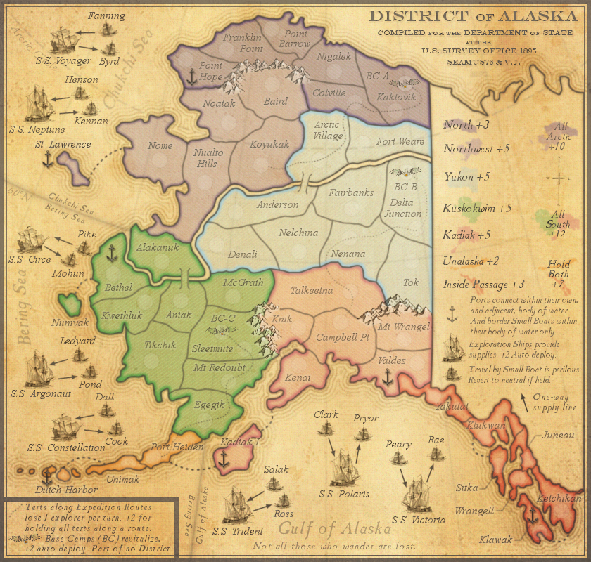
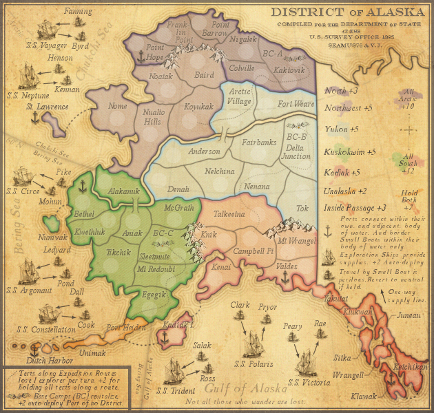
"Colville" on map, "Coleville" in XML.
Point Barrow, Fort Weare, and Franklin Point need to be adjusted to make room for 888. This is a graphical issue, not an XML fix. Kwethluk, Colville and Knik could be moved so that the number doesn't overlap the border. St Lawrence and Dutch Harbor could use a bit of a graphical adjustment to better show the anchor there. (small map)
Are there two territories named Kennan?
Bethel needs to border Dutch Harbor
Sitka-Juneau border on small is unclear (large and small)
Where does it say that boats pointing towards Alaska can attack ports? The "ports" bonus is a bit grammatically incorrect (starts a sentence with And)
Neutrals, starting positions, borders and all but that 1 border is okay
Just to be sure, this is an 8 player max game, right? It could hold more but you won't get the autodeploy ships
Re: District of Alaska - v11.7 [2013-09-26] pg15 XML
Should be Colville, as on the map. We'll update the xml.Gilligan wrote:Seamus and VJ,
"Colville" on map, "Coleville" in XML.
Ok. This brings up a question I had with those. First, the posted 888 version shows all of those overlaps on the small map, so they were technically stamped, but my question is, and my thought process was this: The only part of the 888 that is over lapping will only overlap when players on those terts have 100 or more troops. Obviously the vast majority of games will never reach that point, and the ones that do will have played at least enough rounds to know what the terts are. Is that not right?Gilligan wrote:Point Barrow, Fort Weare, and Franklin Point need to be adjusted to make room for 888. This is a graphical issue, not an XML fix. Kwethluk, Colville and Knik could be moved so that the number doesn't overlap the border.
St Law seems pretty good to me, but I can try moving the Dutch Harbor anchor to the left side.Gilligan wrote:St Lawrence and Dutch Harbor could use a bit of a graphical adjustment to better show the anchor there. (small map)
Good catch. I'll change one and we'll update the xml.Gilligan wrote:Are there two territories named Kennan?
We'll update the xml.Gilligan wrote:Bethel needs to border Dutch Harbor
They do not/should not border each other. If they do in the xml then that is incorrect.Gilligan wrote:Sitka-Juneau border on small is unclear (large and small)
The ports should be able to attack both inbound and outbound small boats. Does the xml show only one of them? If so that is an xml fix we'll take care of.Gilligan wrote:Where does it say that boats pointing towards Alaska can attack ports? The "ports" bonus is a bit grammatically incorrect (starts a sentence with And)
Actually the use of conjunctions is a stylistic preference rather than a grammatical ‘rule’. It also helps to add weight and emphasize the second sentence.Gilligan wrote:The "ports" bonus is a bit grammatically incorrect (starts a sentence with And)
ExcellentGilligan wrote:Neutrals, starting positions, borders and all but that 1 border is okay
Yes, correct. 8 players max.Gilligan wrote:Just to be sure, this is an 8 player max game, right? It could hold more but you won't get the autodeploy ships
Re: District of Alaska - v11.7 [2013-09-26] pg15 XML
Thanks Gilligan.
Should be Colville, as on the map. We'll update the xml.Gilligan wrote:Seamus and VJ,
"Colville" on map, "Coleville" in XML.
Ok. This brings up a question I had with those. First, the posted 888 version shows all of those overlaps on the small map, so they were technically stamped, but my question is, and my thought process was this: The only part of the 888 that is over lapping will only overlap when players on those terts have 100 or more troops. Obviously the vast majority of games will never reach that point, and the ones that do will have played at least enough rounds to know what the terts are. Is that not right?Gilligan wrote:Point Barrow, Fort Weare, and Franklin Point need to be adjusted to make room for 888. This is a graphical issue, not an XML fix. Kwethluk, Colville and Knik could be moved so that the number doesn't overlap the border.
St Law seems pretty good to me, but I can try moving the Dutch Harbor anchor to the left side.Gilligan wrote:St Lawrence and Dutch Harbor could use a bit of a graphical adjustment to better show the anchor there. (small map)
Good catch. I'll change one and we'll update the xml.Gilligan wrote:Are there two territories named Kennan?
We'll update the xml.Gilligan wrote:Bethel needs to border Dutch Harbor
They do not/should not border each other. If they do in the xml then that is incorrect.Gilligan wrote:Sitka-Juneau border on small is unclear (large and small)
The ports should be able to attack both inbound and outbound small boats. Does the xml show only one of them? If so that is an xml fix we'll take care of.Gilligan wrote:Where does it say that boats pointing towards Alaska can attack ports? The "ports" bonus is a bit grammatically incorrect (starts a sentence with And)
Actually the use of conjunctions is a stylistic preference rather than a grammatical ‘rule’. It also helps to add weight and emphasize the second sentence.Gilligan wrote:The "ports" bonus is a bit grammatically incorrect (starts a sentence with And)
ExcellentGilligan wrote:Neutrals, starting positions, borders and all but that 1 border is okay
Yes, correct. 8 players max.Gilligan wrote:Just to be sure, this is an 8 player max game, right? It could hold more but you won't get the autodeploy ships
Re: District of Alaska - v11.7 [2013-09-26] pg15 XML
Gilligan wrote:Point Barrow, Fort Weare, and Franklin Point need to be adjusted to make room for 888. This is a graphical issue, not an XML fix. Kwethluk, Colville and Knik could be moved so that the number doesn't overlap the border.
The only map I see in the first post with 888 are starting positions. The territories that I am talking about have starting neutrals so there's only a single digit on it. If there's another version with all 888s somewhere, I guess link me to that so we can see. Although I can't speak for the graphic CA, I do think it needs to be changed. I will post an 888 here to speed up the process of looking.Seamus76 wrote:Ok. This brings up a question I had with those. First, the posted 888 version shows all of those overlaps on the small map, so they were technically stamped, but my question is, and my thought process was this: The only part of the 888 that is over lapping will only overlap when players on those terts have 100 or more troops. Obviously the vast majority of games will never reach that point, and the ones that do will have played at least enough rounds to know what the terts are. Is that not right?
You also have to remember that many people use color codes (myself included) so anything in double-digit range will obscure this vision (happens quite often). p88 = 888

As you can see, those territories that I mentioned -
Point Barrow, Fort Weare, and Franklin Point overlap names
Kwethluk, Colville and Knik overlap borders
Gilligan wrote:St Lawrence and Dutch Harbor could use a bit of a graphical adjustment to better show the anchor there. (small map)
Look at my above image, I think moving it to the left of the island would be ideal (St Lawrence) and perhaps right before "Dutch" for the other to eliminate confusion with UnimakSeamus76 wrote:St Law seems pretty good to me, but I can try moving the Dutch Harbor anchor to the left side.
Gilligan wrote:Are there two territories named Kennan?
A second territory needs to be added, I'm sure when VJ was doing the XML it yelled at him for having two territories of the same name. It would be easier to change the Kennan by SS Constellation (Need to add an L, I just noticed?) because the Kennan the XML already recognizes is the SS Neptune one. In this case you also need to eliminate the Kennan/Dutch Harbor and Kennan/Bethel borders.Seamus76 wrote:Good catch. I'll change one and we'll update the xml.
Gilligan wrote:Sitka-Juneau border on small is unclear (large and small)
It's good in the XML, but if you look at my small map again it is hard to tell. The large is a bit easier to tell, but taking only a few seconds to move the Sitka troop to the left a little bit will make it that much better.They do not/should not border each other. If they do in the xml then that is incorrect.
Gilligan wrote:Where does it say that boats pointing towards Alaska can attack ports? The "ports" bonus is a bit grammatically incorrect (starts a sentence with And)
Yes, the ports can attack small boats...but can small boats attack ports? It's a big vague in that statement.Seamus76 wrote:The ports should be able to attack both inbound and outbound small boats. Does the xml show only one of them? If so that is an xml fix we'll take care of.
As it is now, outgoing boats can attack ports, but ingoing boats cannot.
I hope this helps.
Re: District of Alaska - v12.0 [2013-09-26] pg16
CURRENT UPDATE INFO - 2013-10-13:
Based on Gilligan's great work finding issues, here are the fixes:
- Point Barrow, Fort Weare, and Franklin Point overlapping names - Fixed (small map)
- Kwethluk, Colville and Knik overlap borders - Fixed (small map)
- Moved St Lawrence and Dutch Harbor anchors (both maps)
- Fixed Constellation misspelling (both maps)
- Changed the duplicate Constellation small boat Kennan to Dall (both maps)
- Rearranged the Sitka army circle and 888 to show the island better (both maps)
- I also posted all new versions of the small and large with 888's & starting neutrals, and a small version with only 888's to show how the 3 digits look for all terts.
We'll get the xml updated asap.
CURRENT MAP VERSION
v12.0 - Large (840x800)
v12.0 - Small (630x600)
Based on Gilligan's great work finding issues, here are the fixes:
- Point Barrow, Fort Weare, and Franklin Point overlapping names - Fixed (small map)
- Kwethluk, Colville and Knik overlap borders - Fixed (small map)
- Moved St Lawrence and Dutch Harbor anchors (both maps)
- Fixed Constellation misspelling (both maps)
- Changed the duplicate Constellation small boat Kennan to Dall (both maps)
- Rearranged the Sitka army circle and 888 to show the island better (both maps)
- I also posted all new versions of the small and large with 888's & starting neutrals, and a small version with only 888's to show how the 3 digits look for all terts.
We'll get the xml updated asap.
CURRENT MAP VERSION
v12.0 - Large (840x800)
- Click image to enlarge.
- Click image to enlarge.
Re: District of Alaska - v12.0 [2013-09-26] pg16
I hate to bring up another issue, but I was curious to see if I'm the only one thinking this.
Even with 88, it can be hard to tell the small boat is ACTUALLY a small boat. Per the legend, it specifically shows small boat text and an image - but on the map, the army number pretty much completely covers the image of the small boat.
Even with 88, it can be hard to tell the small boat is ACTUALLY a small boat. Per the legend, it specifically shows small boat text and an image - but on the map, the army number pretty much completely covers the image of the small boat.
Re: District of Alaska - v12.0 [2013-09-26] pg16
This is an easy fix, just move the numbers next to the boat.Gilligan wrote:I hate to bring up another issue, but I was curious to see if I'm the only one thinking this.
Even with 88, it can be hard to tell the small boat is ACTUALLY a small boat. Per the legend, it specifically shows small boat text and an image - but on the map, the army number pretty much completely covers the image of the small boat.

Re: District of Alaska - v12.0 [2013-09-26] pg16
Agreed...isaiah40 wrote: This is an easy fix, just move the numbers next to the boat.
Re: District of Alaska - v12.0 [2013-09-26] pg16
Unfortunately Pike and Mohun aren't going to work for that. The others would.isaiah40 wrote:This is an easy fix, just move the numbers next to the boat.Gilligan wrote:I hate to bring up another issue, but I was curious to see if I'm the only one thinking this.
Even with 88, it can be hard to tell the small boat is ACTUALLY a small boat. Per the legend, it specifically shows small boat text and an image - but on the map, the army number pretty much completely covers the image of the small boat.
Re: District of Alaska - v12.0 [2013-09-26] pg16
I actually think that Pond would have the biggest issue.
Re: District of Alaska - v12.0 [2013-09-26] pg16
I just tried Pond, and it would be fine. The others however would not. I can try making the small boats larger, but even then there is a limit which may not actually translate into much of a difference.Gilligan wrote:I actually think that Pond would have the biggest issue.
Re: District of Alaska - v12.0 [2013-09-26] pg16
I found a better, and easier fix.Seamus76 wrote:Unfortunately Pike and Mohun aren't going to work for that. The others would.isaiah40 wrote:This is an easy fix, just move the numbers next to the boat.Gilligan wrote:I hate to bring up another issue, but I was curious to see if I'm the only one thinking this.
Even with 88, it can be hard to tell the small boat is ACTUALLY a small boat. Per the legend, it specifically shows small boat text and an image - but on the map, the army number pretty much completely covers the image of the small boat.
- I'm going to use the S.L. prefix for the small boats. So Pond will be, S.L. Pond, and Pike will be S.L. Pike, etc., etc.
I will then put "(S.S.)" on top of the large boat icon in the legend, and "(S.L.)" on top of the small icon. That should do it, no?
Re: District of Alaska - v12.0 [2013-09-26] pg16
That could work too. Just be sure to amend the legend to say "Small Boats (S.L.)" so it's clear what the reference is.Seamus76 wrote:I found a better, and easier fix.Seamus76 wrote:Unfortunately Pike and Mohun aren't going to work for that. The others would.isaiah40 wrote:This is an easy fix, just move the numbers next to the boat.Gilligan wrote:I hate to bring up another issue, but I was curious to see if I'm the only one thinking this.
Even with 88, it can be hard to tell the small boat is ACTUALLY a small boat. Per the legend, it specifically shows small boat text and an image - but on the map, the army number pretty much completely covers the image of the small boat.
- I'm going to use the S.L. prefix for the small boats. So Pond will be, S.L. Pond, and Pike will be S.L. Pike, etc., etc.
I will then put "(S.S.)" on top of the large boat icon in the legend, and "(S.L.)" on top of the small icon. That should do it, no?
When I get home I'll try to see if it's possible to fit all of the numbers in a clear fashion to still show the boats cause they're pretty.
Re: District of Alaska - v12.0 [2013-09-26] pg16
Gilligan wrote:That could work too. Just be sure to amend the legend to say "Small Boats (S.L.)" so it's clear what the reference is.Seamus76 wrote:I found a better, and easier fix.Seamus76 wrote:Unfortunately Pike and Mohun aren't going to work for that. The others would.isaiah40 wrote:This is an easy fix, just move the numbers next to the boat.Gilligan wrote:I hate to bring up another issue, but I was curious to see if I'm the only one thinking this.
Even with 88, it can be hard to tell the small boat is ACTUALLY a small boat. Per the legend, it specifically shows small boat text and an image - but on the map, the army number pretty much completely covers the image of the small boat.
- I'm going to use the S.L. prefix for the small boats. So Pond will be, S.L. Pond, and Pike will be S.L. Pike, etc., etc.
I will then put "(S.S.)" on top of the large boat icon in the legend, and "(S.L.)" on top of the small icon. That should do it, no?
When I get home I'll try to see if it's possible to fit all of the numbers in a clear fashion to still show the boats cause they're pretty.
I didn't leave myself much room to work with, do you think putting the (S.L.) and (S.S.) on the icon rather than in the wording is acceptable?
-
dolomite13

- Posts: 1379
- Joined: Mon Aug 18, 2008 5:54 pm
Re: District of Alaska - v12.0 [2013-09-26] pg16
With such a beautiful map you should really put the numbers above, below or to the side of the boats. It doesn't do justice to the map otherwise.
You probably also already know that your example above was missing a number on the small boat Kennan.
=D13=
You probably also already know that your example above was missing a number on the small boat Kennan.
=D13=
Where Have I Been? ... Testing a prototype board game that I co-designed called Alien Overrun!
Re: District of Alaska - v12.0 [2013-09-26] pg16
How about this?
Here are the coordinates, in order of the ships from north to south.

The rest of the coordinates are not the updated version, so only pay attention to the small boat coordinates. That's why Dall isn't there cause it isn't a territory yet. The large map you should have plenty of room so I won't go there. The only change on Small would have to be the "Chuchi Sea" name. Bering Sea could perhaps go a pixel or two left. Like this you can actually see the small boat images.
Here are the coordinates, in order of the ships from north to south.
Code: Select all
			<smallx>143</smallx>
			<smally>39</smally>

			<smallx>134</smallx>
			<smally>73</smally>

			<smallx>114</smallx>
			<smally>109</smally>

			<smallx>112</smallx>
			<smally>134</smally>

			<smallx>59</smallx>
			<smally>267</smally>

			<smallx>35</smallx>
			<smally>319</smally>

			<smallx>41</smallx>
			<smally>385</smally>

			<smallx>107</smallx>
			<smally>408</smally>

			<smallx>129</smallx>
			<smally>453</smally>

			<smallx>140</smallx>
			<smally>479</smally>

			<smallx>301</smallx>
			<smally>510</smally>

			<smallx>319</smallx>
			<smally>567</smally>

			<smallx>316</smallx>
			<smally>482</smally>

			<smallx>379</smallx>
			<smally>453</smally>

			<smallx>419</smallx>
			<smally>484</smally>

			<smallx>450</smallx>
			<smally>478</smally>
The rest of the coordinates are not the updated version, so only pay attention to the small boat coordinates. That's why Dall isn't there cause it isn't a territory yet. The large map you should have plenty of room so I won't go there. The only change on Small would have to be the "Chuchi Sea" name. Bering Sea could perhaps go a pixel or two left. Like this you can actually see the small boat images.
Re: District of Alaska - v12.0 [2013-09-26] pg16
I think you could fit it in the text. "Travel by Small Boat (S.L.) is perilous. Revert to neutral if held." There seems to be more room after "held" than there is above the small boat image in the legend. Of course I can't do graphics so I will take your word for it. Perhaps we could see both, though, if it is not too much trouble?I didn't leave myself much room to work with, do you think putting the (S.L.) and (S.S.) on the icon rather than in the wording is acceptable?
Re: District of Alaska - v12.0 [2013-09-26] pg16
I've been looking at it all night and unfortunately I can't see a way to make them work except for just adding the S.L. naming convention to the small boats. There is just not enough room for all of them to be moved to the sides, etc.dolomite13 wrote:With such a beautiful map you should really put the numbers above, below or to the side of the boats. It doesn't do justice to the map otherwise.
=D13=
Re: District of Alaska - v12.0 [2013-09-26] pg16
Sorry, I totally missed your posts until after I responded.Gilligan wrote:you don't like the version I posted?
I do like them in the fact that you can see the small boats, and the only graphics change would be reworking the Chukchi Sea label, but the 888's certainly don't look pretty. Does everyone think their positioning is easy to tell what they go to? If that works, then it works for me.