Moderator: Cartographers
OK.Seamus76 wrote:Insert cricket noise here...

Oh koontz, common. Rimmon purple is even brighter than the rivers, and so is Shiloh red. I really think you're grabbing at straws that are imaginery.koontz1973 wrote:... the colours for the impassable rivers. They seem very bright compared to the rest of the colours.

cairnswk wrote:Oh koontz, common. Rimmon purple is even brighter than the rivers, and so is Shiloh red. I really think you're grabbing at straws that are imaginery.koontz1973 wrote:... the colours for the impassable rivers. They seem very bright compared to the rest of the colours.
Seamus, i have no prob wih the colours but up to you if you beleive this koontz guy.


by a river's width, u mean a blue inner glow for the med, which ought to be the same colour as the impassable rivers and not as the dead sea territories?koontz1973 wrote:adding a rivers width to the Med will make it look impassable and not another territ.
Correct. Right now, the Med is the same colour as the dead sea. Make it the same colour as the impassables.iancanton wrote:by a river's width, u mean a blue inner glow for the med, which ought to be the same colour as the impassable rivers and not as the dead sea territories?koontz1973 wrote:adding a rivers width to the Med will make it look impassable and not another territ.
ian.


V.J. sorry to say...but you can complete xml, but the checking process and waiting game for BETA load will wear you even thinner.V.J. wrote:Is there any thoughts on this last update so we can finally get to XML and finish this masterpiece?

Yes, they connect to each other, as indicated by the arrows (I thought), and yes Dead Sea 1 borders both of those. Ein-gedi borders both 1 and 2.ManBungalow wrote:I don't understand the borders on the dead sea regions.
Do they connect to each other?
Does dead sea 1 border Ein-gedi and/or Heshbon?
Upon review, I feel that the Hesbon/Dead sea 1 border is the only one which isn't clear enough.Seamus76 wrote:Yes, they connect to each other, as indicated by the arrows (I thought), and yes Dead Sea 1 borders both of those. Ein-gedi borders both 1 and 2.ManBungalow wrote:I don't understand the borders on the dead sea regions.
Do they connect to each other?
Does dead sea 1 border Ein-gedi and/or Heshbon?
Ok, cool. I'll move the Dead Sea lines and arrows down just a bit, and turn that border line upwards so that there is more space to indicate it does not attack Dead Sea 2. Thanks MB.ManBungalow wrote:Upon review, I feel that the Hesbon/Dead sea 1 border is the only one which isn't clear enough.Seamus76 wrote:Yes, they connect to each other, as indicated by the arrows (I thought), and yes Dead Sea 1 borders both of those. Ein-gedi borders both 1 and 2.ManBungalow wrote:I don't understand the borders on the dead sea regions.
Do they connect to each other?
Does dead sea 1 border Ein-gedi and/or Heshbon?
Ok, I understand now. I think most, if not all players, will recognize that impassables, as listed in the legend are not "playable" parts of any tert, including a water tert, etc. If you don't think that will be intuitively clear then one option would be to put a blue tert line at that river mouth, like there is at the top and bottom of the Dead Sea terts. I think that might look a little odd, but if anyone else see's this as an issue I'll work on a solution.ManBungalow wrote:Sorry, what I mean is this:
Heshbon - a part of the Simeon bonus on the right of the sea - is touched by the river, which goes directly into Dead Sea 1.
Does Dead Sea 1 therefore border Heshbon?
I know a river isn't the same as a sea, but the river/sea outline is one.


The very bottom layer should be the same color as the CC gray so that it blends in and only the map parchment is visible. This is same thing I used for Tribal War - Florida, but it looks like somewhere along the line it became a little lighter. I'll make sure it's changed to what it should be.
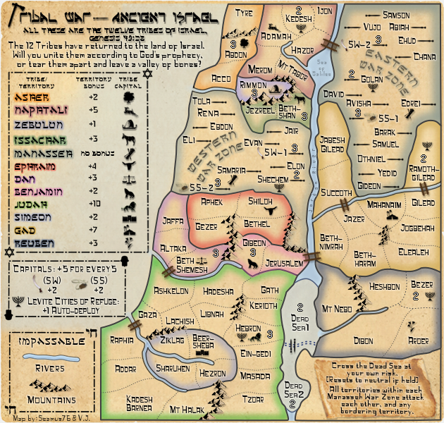
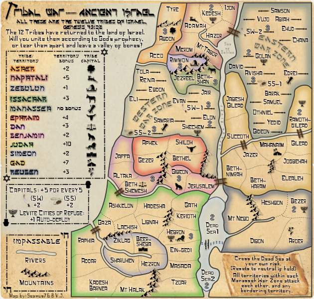
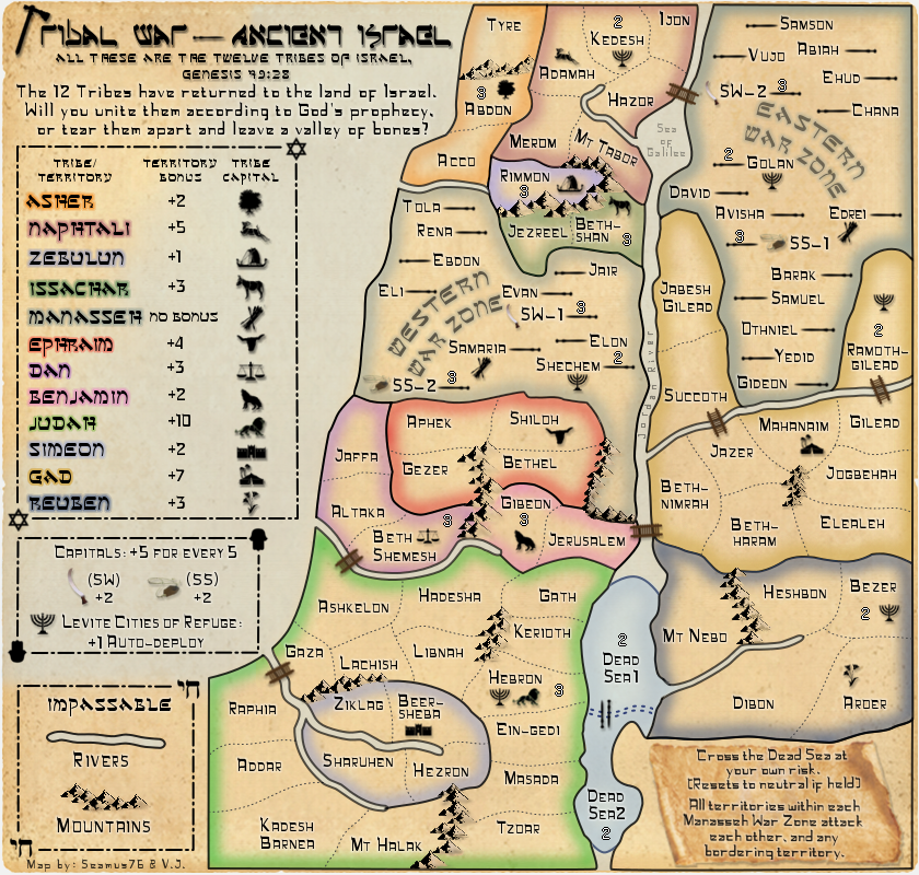
RedBaron0 wrote:The only major thing that bothers me here is the frame around the map, and the white layer that's a part of it. Make that bottom layer be transparent and you should be good.
On that note... the regions that are adjacent to the edge of the map, why are they framed? I think that's what bugging me the most as I think about it, the whole map is extremely boxy and regimented. The frames interrupt the flow of the entire map.
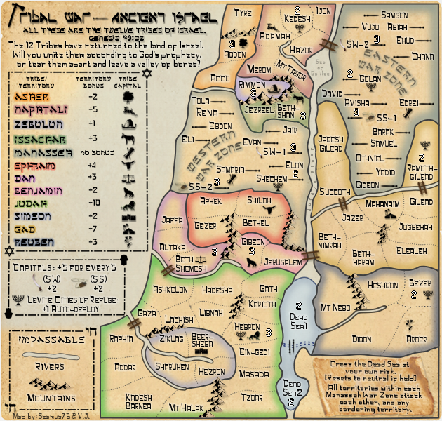