360 view.
http://panoramas.dk/mars/greeley-haven.html
Curiosity Rover on Mars
Moderator: Community Team
Forum rules
Please read the Community Guidelines before posting.
Please read the Community Guidelines before posting.
-
Nola_Lifer

- Posts: 819
- Joined: Mon Oct 13, 2008 4:46 pm
- Location: 雪山
- Contact:

-
KoolBak

- Posts: 7414
- Joined: Fri Feb 03, 2006 1:03 pm
- Gender: Male
- Location: The beautiful Pacific Northwest
Re: Curiosity Rover Lands on Mars
Very cool....some day, that's an entire new planet we can colonize.....it would be very helpful.
Baron, I was referring to this article:
http://www.newsmax.com/SciTech/rocket-russia-telecom-failure/2012/08/07/id/447764
Baron, I was referring to this article:
http://www.newsmax.com/SciTech/rocket-russia-telecom-failure/2012/08/07/id/447764
"Gypsy told my fortune...she said that nothin showed...."
Neil Young....Like An Inca
AND:
Neil Young....Like An Inca
AND:
riskllama wrote:Koolbak wins this thread.
-
AndyDufresne

- Posts: 24935
- Joined: Fri Mar 03, 2006 8:22 pm
- Location: A Banana Palm in Zihuatanejo
- Contact:
Re: Curiosity Rover Lands on Mars
Some new images. All images of course are NASA/JPL.
Check 'em out!
Also, News update:
[spoiler=New update] Meanwhile, Curiosity has finished a four-day process transitioning both of its redundant main computers to flight software for driving and using tools on the rover's arm. During the latter part of the Mars Science Laboratory spacecraft's 36-week flight to Mars and its complicated descent to deliver Curiosity to the Martian surface on Aug. 5, PDT (Aug. 6, EDT and Universal Time), the rover's computers used a version of flight software with many capabilities no longer needed. The new version expands capabilities for work the rover will do now that it is on Mars.
"We have successfully completed the brain transplant," said Curiosity Mission Manager Mike Watkins of NASA's Jet Propulsion Laboratory, Pasadena, Calif. "Now we are moving on to a new phase of functional checkouts of the science instruments and preparations for a short test drive."
The first drive, possibly within a week or so, will likely include short forward and reverse segments and a turn. Curiosity has a separate drive motor on each of its six wheels and steering motors on the four corner wheels. Preparation and testing of the motor controllers will precede the first drive.
After the test drive, the planning schedule has an "intermission" before a second testing phase focused on use of the rover's robotic arm. For the intermission, the 400-member science team will have the opportunity to pick a location for Curiosity to drive to before the arm-testing weeks.
During a prime mission of nearly two years, researchers will use Curiosity to investigate whether the selected area of Mars has ever offered chemical ingredients for life and other environmental conditions favorable for supporting microbial life. Curiosity carries 10 science instruments with a total mass 15 times as large as the science payloads on NASA's Mars rovers Spirit and Opportunity. [/spoiler]
[spoiler=Color Enhanced, from Above]This color-enhanced view of NASA's Curiosity rover on the surface of Mars was taken by the High Resolution Imaging Science Experiment (HiRISE) on NASA's Mars Reconnaissance Orbiter as the satellite flew overhead. Image credit: NASNASA/JPL-Caltech/University of Arizona.
 [/spoiler]
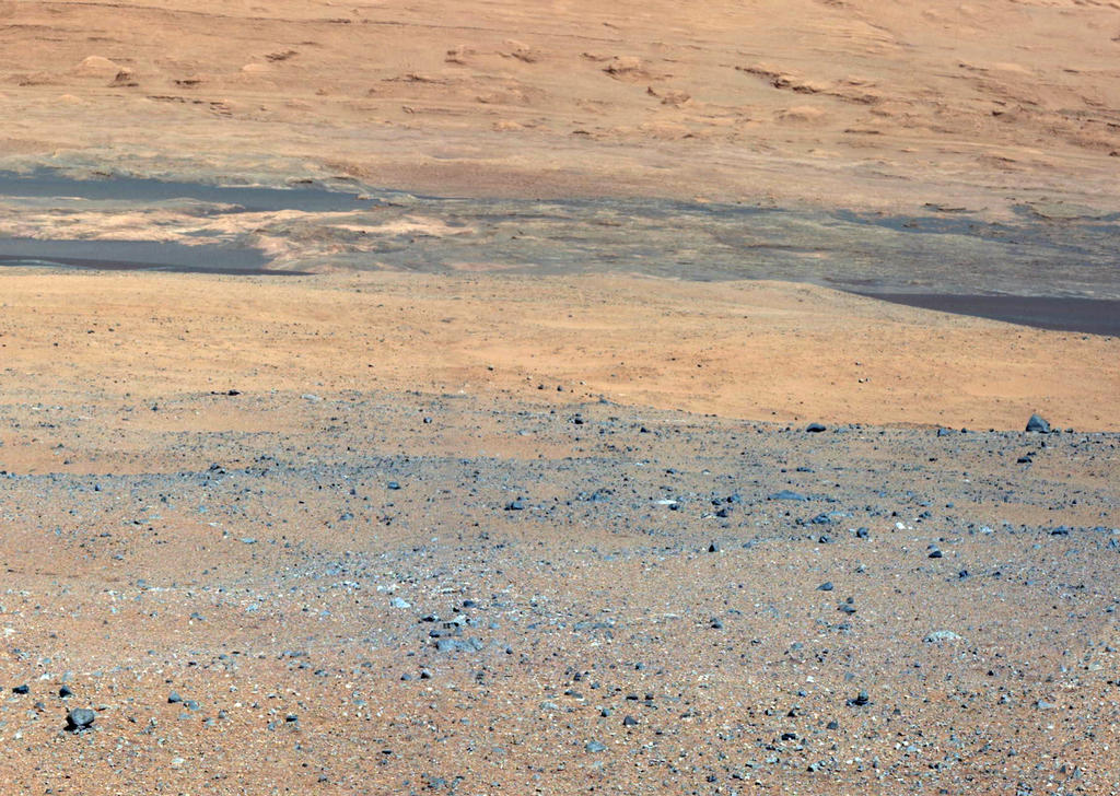
[spoiler=Color, Mastcam Mega Horizon]This image is the first high-resolution color mosaic from NASA's Curiosity rover, showing the geological environment around the rover's landing site in Gale Crater on Mars. The images show a landscape that closely resembles portions of the southwestern United States in its morphology, adding to the impression gained from the lower-resolution thumbnail mosaic released early in the week.
The colors in the main image are unmodified from those returned by the camera. While it is difficult to say whether this is what a human eye would see, it is what a cell phone or camcorder would record since the Mastcam takes color pictures in the exact same manner that consumer cameras acquire color images.

To see a giant image suitable for outside of forum viewing, check out: http://mars.jpl.nasa.gov/msl/images/pia ... er-br2.jpg[/spoiler]
[spoiler=Color Modified, Mount Sharp]This image from NASA's Curiosity rover looks south of the rover's landing site on Mars towards Mount Sharp. This is part of a larger,high-resolution color mosaic made from images obtained by Curiosity's Mast Camera.
In this version of the image, colors have been modified as if the scene were transported to Earth and illuminated by terrestrial sunlight. This processing, called "white balancing," is useful for scientists to be able to recognize and distinguish rocks by color in more familiar lighting.
The image provides an overview of the eventual geological targets Curiosity will explore over the next two years, starting with the rock-strewn, gravelly surface close by, and extending towards the dark dunefield. Beyond that lie the layered buttes and mesas of the sedimentary rock of Mount Sharp.
 [/spoiler]
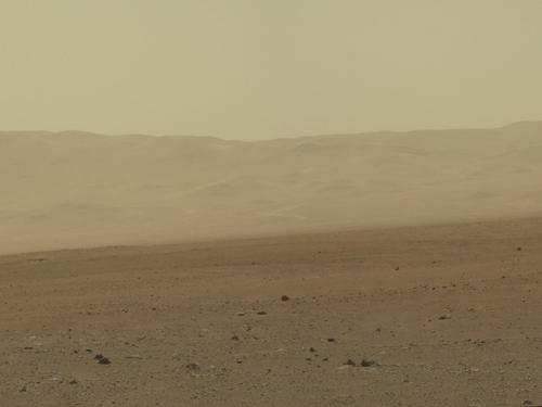
[spoiler=Color, Wall of Gale Crater]This color image from NASA's Curiosity rover shows part of the wall of Gale Crater, the location on Mars where the rover landed on Aug. 5, 2012 PDT (Aug. 6, 2012 EDT). This is part of a larger, high-resolution color mosaic made from images obtained by Curiosity's Mast Camera.
This image of the crater wall is north of the landing site, or behind the rover. Here, a network of valleys believed to have formed by water erosion enters Gale Crater from the outside. This is the first view scientists have had of a fluvial system - one relating to a river or stream -- from the surface of Mars. Known and studied since the 1970s beginning with NASA's Viking missions, such networks date from a period in Martian history when water flowed freely across the surface. The main channel deposit seen here resembles a dirt road ascending into the mountains, which are actually the north wall and rim of Gale Crater.
Although Curiosity is about 11 miles (18 kilometers) away from this area and the view is obscured somewhat by dust and haze, the image provides new insights into the style of sediment transport within this system. Curiosity has no current plans to visit this valley system, since the primary objective of the rover is south of the landing site. But images taken later and with the 100-millimeter Mastcam are likely to allow scientists to study the area in significantly more detail.
 [/spoiler]
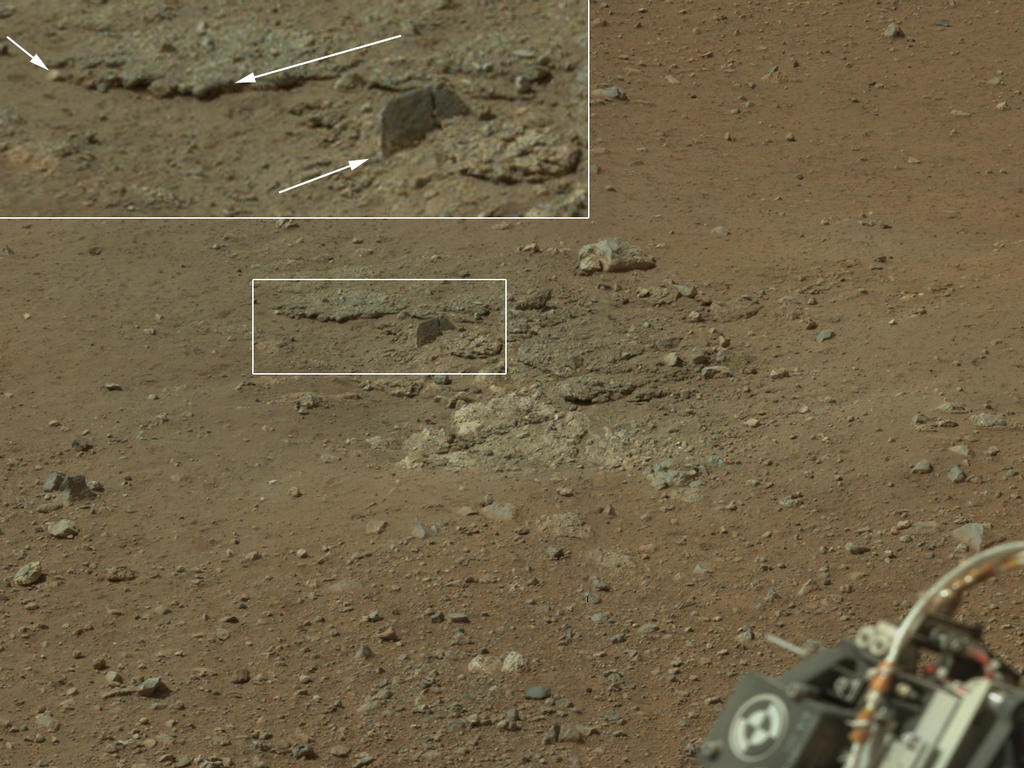
[spoiler=Color, Rock Uncovered by Rockets]This color image from NASA's Curiosity rover shows an area excavated by the blast of the Mars Science Laboratory’s descent stage rocket engines. This is part of a larger, high-resolution color mosaic made from images obtained by Curiosity's Mast Camera.
With the loose debris blasted away by the rockets, details of the underlying materials are clearly seen. Of particular note is a well-defined, topmost layer that contains fragments of rock embedded in a matix of finer material. Shown in the inset in the figure are pebbles up to 1.25 inches (about 3 centimeters) across (upper two arrows) and a larger clast 4 inches (11.5 centimeters) long protruding up by about 2 inches (10 centimeters) from the layer in which it is embedded. Clast-rich sedimentary layers can form in a number of ways. Their mechanisms of formation can be distinguished by the size, shape, surface textures and positioning with respect to each other of the fragments in the layers.
 [/spoiler]
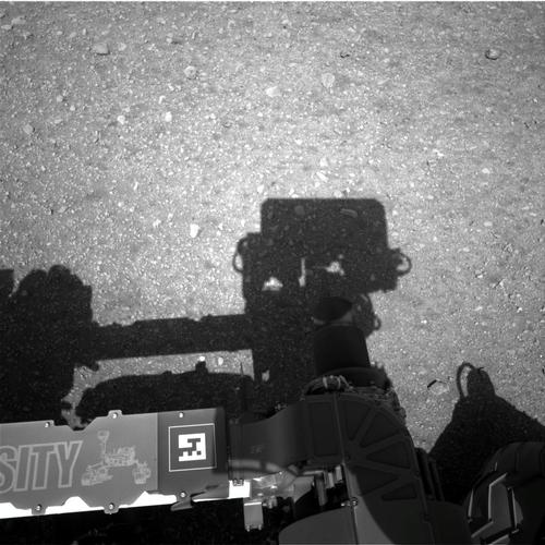
[spoiler=BW, Mastcam Shadow]This is the first image taken by the Navigation cameras on NASA's Curiosity rover. It shows the shadow of the rover's now-upright mast in the center, and the arm's shadow at left. The arm itself can be seen in the foreground.
The navigation camera is used to help find the sun -- information that is needed for locating, and communicating, with Earth. After the camera pointed at the sun, it turned in the opposite direction and took this picture. The position of the shadow helps confirm the sun's location.
The "augmented reality" or AR tag seen in the foreground can be used in the future with smart phones to obtain more information about the mission.
 [/spoiler]
--Andy
Check 'em out!
Also, News update:
[spoiler=New update] Meanwhile, Curiosity has finished a four-day process transitioning both of its redundant main computers to flight software for driving and using tools on the rover's arm. During the latter part of the Mars Science Laboratory spacecraft's 36-week flight to Mars and its complicated descent to deliver Curiosity to the Martian surface on Aug. 5, PDT (Aug. 6, EDT and Universal Time), the rover's computers used a version of flight software with many capabilities no longer needed. The new version expands capabilities for work the rover will do now that it is on Mars.
"We have successfully completed the brain transplant," said Curiosity Mission Manager Mike Watkins of NASA's Jet Propulsion Laboratory, Pasadena, Calif. "Now we are moving on to a new phase of functional checkouts of the science instruments and preparations for a short test drive."
The first drive, possibly within a week or so, will likely include short forward and reverse segments and a turn. Curiosity has a separate drive motor on each of its six wheels and steering motors on the four corner wheels. Preparation and testing of the motor controllers will precede the first drive.
After the test drive, the planning schedule has an "intermission" before a second testing phase focused on use of the rover's robotic arm. For the intermission, the 400-member science team will have the opportunity to pick a location for Curiosity to drive to before the arm-testing weeks.
During a prime mission of nearly two years, researchers will use Curiosity to investigate whether the selected area of Mars has ever offered chemical ingredients for life and other environmental conditions favorable for supporting microbial life. Curiosity carries 10 science instruments with a total mass 15 times as large as the science payloads on NASA's Mars rovers Spirit and Opportunity. [/spoiler]
[spoiler=Color Enhanced, from Above]This color-enhanced view of NASA's Curiosity rover on the surface of Mars was taken by the High Resolution Imaging Science Experiment (HiRISE) on NASA's Mars Reconnaissance Orbiter as the satellite flew overhead. Image credit: NASNASA/JPL-Caltech/University of Arizona.
[/spoiler][spoiler=Color, Mastcam Mega Horizon]This image is the first high-resolution color mosaic from NASA's Curiosity rover, showing the geological environment around the rover's landing site in Gale Crater on Mars. The images show a landscape that closely resembles portions of the southwestern United States in its morphology, adding to the impression gained from the lower-resolution thumbnail mosaic released early in the week.
The colors in the main image are unmodified from those returned by the camera. While it is difficult to say whether this is what a human eye would see, it is what a cell phone or camcorder would record since the Mastcam takes color pictures in the exact same manner that consumer cameras acquire color images.
To see a giant image suitable for outside of forum viewing, check out: http://mars.jpl.nasa.gov/msl/images/pia ... er-br2.jpg[/spoiler]
[spoiler=Color Modified, Mount Sharp]This image from NASA's Curiosity rover looks south of the rover's landing site on Mars towards Mount Sharp. This is part of a larger,high-resolution color mosaic made from images obtained by Curiosity's Mast Camera.
In this version of the image, colors have been modified as if the scene were transported to Earth and illuminated by terrestrial sunlight. This processing, called "white balancing," is useful for scientists to be able to recognize and distinguish rocks by color in more familiar lighting.
The image provides an overview of the eventual geological targets Curiosity will explore over the next two years, starting with the rock-strewn, gravelly surface close by, and extending towards the dark dunefield. Beyond that lie the layered buttes and mesas of the sedimentary rock of Mount Sharp.
[/spoiler][spoiler=Color, Wall of Gale Crater]This color image from NASA's Curiosity rover shows part of the wall of Gale Crater, the location on Mars where the rover landed on Aug. 5, 2012 PDT (Aug. 6, 2012 EDT). This is part of a larger, high-resolution color mosaic made from images obtained by Curiosity's Mast Camera.
This image of the crater wall is north of the landing site, or behind the rover. Here, a network of valleys believed to have formed by water erosion enters Gale Crater from the outside. This is the first view scientists have had of a fluvial system - one relating to a river or stream -- from the surface of Mars. Known and studied since the 1970s beginning with NASA's Viking missions, such networks date from a period in Martian history when water flowed freely across the surface. The main channel deposit seen here resembles a dirt road ascending into the mountains, which are actually the north wall and rim of Gale Crater.
Although Curiosity is about 11 miles (18 kilometers) away from this area and the view is obscured somewhat by dust and haze, the image provides new insights into the style of sediment transport within this system. Curiosity has no current plans to visit this valley system, since the primary objective of the rover is south of the landing site. But images taken later and with the 100-millimeter Mastcam are likely to allow scientists to study the area in significantly more detail.
[/spoiler][spoiler=Color, Rock Uncovered by Rockets]This color image from NASA's Curiosity rover shows an area excavated by the blast of the Mars Science Laboratory’s descent stage rocket engines. This is part of a larger, high-resolution color mosaic made from images obtained by Curiosity's Mast Camera.
With the loose debris blasted away by the rockets, details of the underlying materials are clearly seen. Of particular note is a well-defined, topmost layer that contains fragments of rock embedded in a matix of finer material. Shown in the inset in the figure are pebbles up to 1.25 inches (about 3 centimeters) across (upper two arrows) and a larger clast 4 inches (11.5 centimeters) long protruding up by about 2 inches (10 centimeters) from the layer in which it is embedded. Clast-rich sedimentary layers can form in a number of ways. Their mechanisms of formation can be distinguished by the size, shape, surface textures and positioning with respect to each other of the fragments in the layers.
[/spoiler][spoiler=BW, Mastcam Shadow]This is the first image taken by the Navigation cameras on NASA's Curiosity rover. It shows the shadow of the rover's now-upright mast in the center, and the arm's shadow at left. The arm itself can be seen in the foreground.
The navigation camera is used to help find the sun -- information that is needed for locating, and communicating, with Earth. After the camera pointed at the sun, it turned in the opposite direction and took this picture. The position of the shadow helps confirm the sun's location.
The "augmented reality" or AR tag seen in the foreground can be used in the future with smart phones to obtain more information about the mission.
[/spoiler]--Andy
-
KoolBak
- Posts: 7414
- Joined: Fri Feb 03, 2006 1:03 pm
- Gender: Male
- Location: The beautiful Pacific Northwest
Re: Curiosity Rover Lands on Mars
Thanks!
"Gypsy told my fortune...she said that nothin showed...."
Neil Young....Like An Inca
AND:
Neil Young....Like An Inca
AND:
riskllama wrote:Koolbak wins this thread.


Re: Curiosity Rover Lands on Mars
AndyDufresne wrote:puppydog85 wrote:Andy (or anyone else),
Pardon my ignorance but why black and white? How much did they spend on those things? What about an auto-focus? Or is there some reason that makes that really hard to get on mars (like costing 3B instead of 1B or whatever they spent)?
The images you've been seeing initially aren't from the main color imaging camera and video. They are primarily from 'Hazard Cams' which are more geared for simply keeping the Rover safe and evaluating where it is in the environment. Think of them kind of like the rear view and side mirrors in a car, and not the windshield which gives you a bigger and more detailed view. The main camera I think is (or will be soon) up an running, and at the point color photos with high resolution will be made available by the Rover.
Additionally, the Rover first usually sends small thumbnails (since they are small in data size and can be sent more quickly), and then slightly better resolution, and then full resolution big photos.
I'll post some more photo and video updates perhaps later today after this afternoon's news conference!
--Andy
that, and they need to airbrush out all evidence of life
[bigimg]http://sense4seo.nl/signatures/sig-zimmah.jpg[/bigimg]
-
AndyDufresne
- Posts: 24935
- Joined: Fri Mar 03, 2006 8:22 pm
- Location: A Banana Palm in Zihuatanejo
- Contact:
Re: Curiosity Rover Lands on Mars
Shhh, it's our secret!
--Andy
--Andy
Re: Curiosity Rover Lands on Mars
don't worry, FBI will kill anyone who read it before their hackers delete it and all trace of it.
[bigimg]http://sense4seo.nl/signatures/sig-zimmah.jpg[/bigimg]
-
thegreekdog

- Posts: 7246
- Joined: Thu Jul 17, 2008 6:55 am
- Gender: Male
- Location: Philadelphia
Re: Curiosity Rover Lands on Mars
Are the NASA folks convinced that the smudge from the first picture was just a smudge?
thegreekdog crosses his fingers and hopes it's more than a smudge
thegreekdog crosses his fingers and hopes it's more than a smudge

-
BigBallinStalin

- Posts: 5151
- Joined: Sun Oct 26, 2008 10:23 pm
- Location: crying into the dregs of an empty bottle of own-brand scotch on the toilet having a dump in Dagenham
- Contact:
Re: Curiosity Rover Lands on Mars

Water Has Been Discovered on Mars


Re: Curiosity Rover Lands on Mars
I hope that Curiosity can extend itself beyond its planned two year (668 sols, to be exact, or essentially one Martian solar year) mission as successfully as Spirit did (21.6 times as long as its original 90-sol plan) and Opportunity is doing (over thirty times and counting). [A Sol is a Martian solar day, which is 24 hours, 39 minutes, and 35.244 seconds in length, on average.]
-
AndyDufresne
- Posts: 24935
- Joined: Fri Mar 03, 2006 8:22 pm
- Location: A Banana Palm in Zihuatanejo
- Contact:
Re: Curiosity Rover Lands on Mars
ender516 wrote:I hope that Curiosity can extend itself beyond its planned two year (668 sols, to be exact, or essentially one Martian solar year) mission as successfully as Spirit did (21.6 times as long as its original 90-sol plan) and Opportunity is doing (over thirty times and counting). [A Sol is a Martian solar day, which is 24 hours, 39 minutes, and 35.244 seconds in length, on average.]
I hope so too! The return on investment from Spirit and Opportunity has been pretty tremendous, and it would be great to see something similar with the MSL.
========
On August 19th, NASA's Mars rover Curiosity fired its laser for the first time on Mars, using the beam from a science instrument to interrogate a fist-size rock called "Coronation."
The mission's Chemistry and Camera instrument, or ChemCam, hit the fist-sized rock with 30 pulses of its laser during a 10-second period. Each pulse delivers more than a million watts of power for about five one-billionths of a second.
The energy from the laser excites atoms in the rock into an ionized, glowing plasma. ChemCam catches the light from that spark with a telescope and analyzes it with three spectrometers for information about what elements are in the target.
[spoiler=BW photo showing the readying of the Chem cam]This image shows the calibration target for the Chemistry and Camera (ChemCam) instrument on NASA's Curiosity rover. The calibration target is one square and a group of nine circles that look dark in the black-and-white image. The calibration target set can be seen in the middle left in this image, to the right of the rover's power source. The materials used in these circles are the types of materials scientists anticipated they might encounter on Mars. The square is a titanium alloy with a painted edge.
 [/spoiler]
[spoiler=BW photo of ChemCam laser test]This composite image, with magnified insets, depicts the first laser test by the Chemistry and Camera, or ChemCam, instrument aboard NASA's Curiosity Mars rover. The composite incorporates a Navigation Camera image taken prior to the test, with insets taken by the camera in ChemCam. The circular insert highlights the rock before the laser test. The square inset is further magnified and processed to show the difference between images taken before and after the laser interrogation of the rock.
ChemCam recorded spectra from the laser-induced spark at each of the 30 pulses. The goal of this initial use of the laser on Mars was to serve as target practice for characterizing the instrument, but the activity may provide additional value. Researchers will check whether the composition changed as the pulses progressed. If it did change, that could indicate dust or other surface material being penetrated to reveal different composition beneath the surface. The spectrometers record intensity at 6,144 different wavelengths of ultraviolet, visible and infrared light.
The technique used by ChemCam, called laser-induced breakdown spectroscopy, has been used to determine composition of targets in other extreme environments, such as inside nuclear reactors and on the sea floor, and has had experimental applications in environmental monitoring and cancer detection. Today's investigation of Coronation is the first use of the technique in interplanetary exploration.
 [/spoiler]
--Andy
-
Nola_Lifer
- Posts: 819
- Joined: Mon Oct 13, 2008 4:46 pm
- Location: 雪山
- Contact:
-
AndyDufresne
- Posts: 24935
- Joined: Fri Mar 03, 2006 8:22 pm
- Location: A Banana Palm in Zihuatanejo
- Contact:
Re: Curiosity Rover Lands on Mars
Nola_Lifer wrote:That is actually pretty bad ass.
It is a pretty intense laser. Spirit and Opportunity had to touch rock specimens to determine their composition, and could take a couple of days doing all of this.
ChemCam's laser removes the need to actually touch the rock specimen. And it can shoot the laser from a distance of up to 7m (~25 ft)! The ChemCam team expects to take approximately one dozen compositional measurements of rocks per day on average I think.
--Andy
-
BigBallinStalin
- Posts: 5151
- Joined: Sun Oct 26, 2008 10:23 pm
- Location: crying into the dregs of an empty bottle of own-brand scotch on the toilet having a dump in Dagenham
- Contact:
Re: Curiosity Rover Lands on Mars
Will the Martians be compensated for the damages to their rocks?
Re: Curiosity Rover Lands on Mars
Only if they present themselves in person in court.
-
BigBallinStalin
- Posts: 5151
- Joined: Sun Oct 26, 2008 10:23 pm
- Location: crying into the dregs of an empty bottle of own-brand scotch on the toilet having a dump in Dagenham
- Contact:
Re: Curiosity Rover Lands on Mars
Where's Martian Marx when you need him?
-
AndyDufresne
- Posts: 24935
- Joined: Fri Mar 03, 2006 8:22 pm
- Location: A Banana Palm in Zihuatanejo
- Contact:
Re: Curiosity Rover Lands on Mars
BigBallinStalin wrote:Where's Martian Marx when you need him?
He's rooming with Marvin the Martian I think, and probably hung over.
--Andy
-
thegreekdog
- Posts: 7246
- Joined: Thu Jul 17, 2008 6:55 am
- Gender: Male
- Location: Philadelphia
Re: Curiosity Rover Lands on Mars
Ironically (because I didn't start reading it because of the Mars mission), I'm reading Stranger in a Strange Land. I was skeptical (I liked Starship Troopers, but not that much), but the book is fantastic.
Re: Curiosity Rover Lands on Mars
thegreekdog wrote:Ironically (because I didn't start reading it because of the Mars mission), I'm reading Stranger in a Strange Land. I was skeptical (I liked Starship Troopers, but not that much), but the book is fantastic.
grokked.

-
BigBallinStalin
- Posts: 5151
- Joined: Sun Oct 26, 2008 10:23 pm
- Location: crying into the dregs of an empty bottle of own-brand scotch on the toilet having a dump in Dagenham
- Contact:
Re: Curiosity Rover Lands on Mars
thegreekdog wrote:Ironically (because I didn't start reading it because of the Mars mission), I'm reading Stranger in a Strange Land. I was skeptical (I liked Starship Troopers, but not that much), but the book is fantastic.
That's good to hear. Three pages in, it seemed too prosaic, but maybe I'll give it whirl sometime.
-
thegreekdog
- Posts: 7246
- Joined: Thu Jul 17, 2008 6:55 am
- Gender: Male
- Location: Philadelphia
Re: Curiosity Rover Lands on Mars
BigBallinStalin wrote:thegreekdog wrote:Ironically (because I didn't start reading it because of the Mars mission), I'm reading Stranger in a Strange Land. I was skeptical (I liked Starship Troopers, but not that much), but the book is fantastic.
That's good to hear. Three pages in, it seemed too prosaic, but maybe I'll give it whirl sometime.
I was highly skeptical a few years ago (when I went on a science fiction binge) because of the cover (which is not science fictiony at all - more like romance novel). It's good. Lots of Libertarian stuff in there too for your reading pleasure.
-
AndyDufresne
- Posts: 24935
- Joined: Fri Mar 03, 2006 8:22 pm
- Location: A Banana Palm in Zihuatanejo
- Contact:
Re: Curiosity Rover Lands on Mars
NASA's Mars rover Curiosity has been investigating the Martian weather around it and the soil beneath it, as its controllers prepare for the car-size vehicle's first drive on Mars.
An instrument provided by Russia is checking for water bound into minerals in the top three feet (one meter) of soil beneath the rover. It employs a technology that is used in oil prospecting on Earth, but had never before been sent to another planet.
"Curiosity has begun shooting neutrons into the ground," said Igor Mitrofanov of Space Research Institute, Moscow, principal investigator for this instrument, called the Dynamic Albedo of Neutrons, or DAN. "We measure the amount of hydrogen in the soil by observing how the neutrons are scattered, and hydrogen on Mars is an indicator of water."
The most likely hydrogen to be found in shallow ground of Gale Crater, near the Martian equator, is in hydrated minerals. These are minerals with water molecules, or related ions, bound into the crystalline structure of rocks. They can tenaciously retain water from a wetter past after all free water has gone.
Curiosity will soon have a different patch of ground beneath it.
[spoiler=BW Composite Photo, Self Portrait of the Curiosity Rover] [/spoiler]
Today, the six-wheeled rover wiggled its four corner wheels side to side for the first time on Mars, as a test of the steering actuators on those wheels. This was critical preparation for Curiosity's first drive on Mars.
[spoiler=BW Photo-Video GIF, Wheel Test]This set of images shows the movement of the rear right wheel of NASA's Curiosity as rover drivers turned the wheels in place at the landing site on Mars. Engineers wiggled the wheels as a test of the rover's steering and anticipate embarking on Curiosity's first drive in the next couple of days. This image was taken by one of Curiosity's Navigation cameras on Aug. 21.
 [/spoiler]
The rover's weather station, provided by Spain, checks air temperature, ground temperature, air pressure, wind and other variables every hour at the landing site in Gale Crater.
One of the two sets of REMS wind sensors is not providing data. "One possibility is that pebbles lofted during the landing hit the delicate circuit boards on one of the two REMS booms," said Curiosity Deputy Project Scientist Ashwin Vasavada of NASA's Jet Propulsion Laboratory, Pasadena, Calif. "We will have to be more clever about using the remaining wind sensor to get wind speed and direction."
[spoiler=Temperature Data Chart]This graph shows the rise and fall of air and ground temperatures on Mars obtained by NASA's Curiosity rover. The data cover Aug. 16 to Aug. 17, 2012 and were taken by the Rover Environmental Monitoring Station. Ground temperatures vary from as high as 37 degrees Fahrenheit (3 degrees Celsius) to as low as minus 131.8 degrees Fahrenheit (minus 91 degrees Celsius), showing large temperature oscillations from day to night. Air temperatures vary from as high as 28 degrees Fahrenheit (minus 2 degrees Celsius) to as low as minus 103 degrees Fahrenheit (minus 75 degrees Celsius), indicating, as expected, variations in air temperatures are less extreme than ground temperature variations.
 [/spoiler]
--Andy
An instrument provided by Russia is checking for water bound into minerals in the top three feet (one meter) of soil beneath the rover. It employs a technology that is used in oil prospecting on Earth, but had never before been sent to another planet.
"Curiosity has begun shooting neutrons into the ground," said Igor Mitrofanov of Space Research Institute, Moscow, principal investigator for this instrument, called the Dynamic Albedo of Neutrons, or DAN. "We measure the amount of hydrogen in the soil by observing how the neutrons are scattered, and hydrogen on Mars is an indicator of water."
The most likely hydrogen to be found in shallow ground of Gale Crater, near the Martian equator, is in hydrated minerals. These are minerals with water molecules, or related ions, bound into the crystalline structure of rocks. They can tenaciously retain water from a wetter past after all free water has gone.
Curiosity will soon have a different patch of ground beneath it.
[spoiler=BW Composite Photo, Self Portrait of the Curiosity Rover]
[/spoiler]Today, the six-wheeled rover wiggled its four corner wheels side to side for the first time on Mars, as a test of the steering actuators on those wheels. This was critical preparation for Curiosity's first drive on Mars.
[spoiler=BW Photo-Video GIF, Wheel Test]This set of images shows the movement of the rear right wheel of NASA's Curiosity as rover drivers turned the wheels in place at the landing site on Mars. Engineers wiggled the wheels as a test of the rover's steering and anticipate embarking on Curiosity's first drive in the next couple of days. This image was taken by one of Curiosity's Navigation cameras on Aug. 21.
[/spoiler]The rover's weather station, provided by Spain, checks air temperature, ground temperature, air pressure, wind and other variables every hour at the landing site in Gale Crater.
One of the two sets of REMS wind sensors is not providing data. "One possibility is that pebbles lofted during the landing hit the delicate circuit boards on one of the two REMS booms," said Curiosity Deputy Project Scientist Ashwin Vasavada of NASA's Jet Propulsion Laboratory, Pasadena, Calif. "We will have to be more clever about using the remaining wind sensor to get wind speed and direction."
[spoiler=Temperature Data Chart]This graph shows the rise and fall of air and ground temperatures on Mars obtained by NASA's Curiosity rover. The data cover Aug. 16 to Aug. 17, 2012 and were taken by the Rover Environmental Monitoring Station. Ground temperatures vary from as high as 37 degrees Fahrenheit (3 degrees Celsius) to as low as minus 131.8 degrees Fahrenheit (minus 91 degrees Celsius), showing large temperature oscillations from day to night. Air temperatures vary from as high as 28 degrees Fahrenheit (minus 2 degrees Celsius) to as low as minus 103 degrees Fahrenheit (minus 75 degrees Celsius), indicating, as expected, variations in air temperatures are less extreme than ground temperature variations.
[/spoiler] --Andy
-
thegreekdog
- Posts: 7246
- Joined: Thu Jul 17, 2008 6:55 am
- Gender: Male
- Location: Philadelphia
-
IcePack

- Multi Hunter

- Posts: 16849
- Joined: Wed Aug 04, 2010 6:42 pm
- Gender: Male
- Location: California
Re: Curiosity Rover Lands on Mars
Will the title remain "lands on mars" for the whole 2 year mission, or periodically updated as new things develop? 
IcePack
IcePack

fac vitam incredibilem memento vivere
Knowledge Weighs Nothing, Carry All You Can