
[bigimg]http://i141.photobucket.com/albums/r76/ron_parodi/Indian%20Empire/india20L.jpg[/bigimg]
Basics:
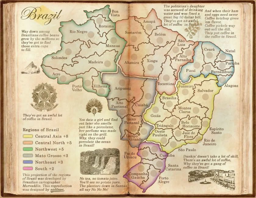
42 territories.
Six traditional bonus regions, plus three sub bonuses for holding rail line between cities... the two southern lines cross multiple regions, and the Calcutta-Delhi line runs through the heart of a huge region that will be all but impossible to hold - thus the mini-bonuses to encourage activity in the center.
Nepal and Bhotan are NOT in play - there was discussion about having them as non-region territories, but that was a bad idea on my part.
Background:
With the Brazil revamp competition over, I wanted to recycle the look of my Brazil entry. My first idea was to try Japan (clicky), and I do believe that a japan map can work if the mapmaker were less ambitious about squeezing in territories than in the past attempts. But ultimately I don't feel that Japan is the right map for this background, so I've secured InkLosed's permission to pick up where he left off on the Indian Subcontinent map. This isn't a redux of InkLosed's map, but since he was the last to work on this I thought it would be polite to ask.
India has been attempted at least five times that I can find, but has proved as elusive catch. I'm not basing this map on any of the previous attempts, but I have looked over them to try to avoid the problems faced by the other mapmakers. I'm setting this in the 19th century, about 1870ish, after the British had brought the country under British rule and put down the mid-century rebellions. Territory and region names conform to 19th century conventions - yes, some spellings are funny, and Calcutta isn't Calcutta anymore, but as far as I can tell the names are historically accurate.
The past efforts are as follows, with links to the old threads:
InkLosed's Indian Subcontinent map. clicky
Reverand Kyles's India. clicky
Contrickster's Jewell of the Empire. clicky
ConformOrDie's Indian Presidencies. clicky
Gavin's Indian Subcontinent. clicky
Indian Empire [Quenched]
Moderator: Cartographers
Forum rules
Please read the Community Guidelines before posting.
Please read the Community Guidelines before posting.
Indian Empire [Quenched]
Last edited by thenobodies80 on Wed Sep 30, 2009 12:36 pm, edited 11 times in total.
Reason: Removed poll
Reason: Removed poll

Re: Indian Subcontinent - rising from the ashes?
Awesome, I'm glad the Brazil book background is getting some use.
If you went by old British colonial divisions of land would it give you more territories?
If you went by old British colonial divisions of land would it give you more territories?
-
Incandenza

- Posts: 4949
- Joined: Thu Oct 19, 2006 5:34 pm
- Gender: Male
- Location: Playing Eschaton with a bucket of old tennis balls
Re: Indian Subcontinent - rising from the ashes?
If you're thinking about a Sepoy Rebellion concept, then perhaps a couple of the major terits that figured in the war (dunno off the top of my head what those would be), could feature castles or forts which have either iraq-style loyalty squares or bamboo jack-style submaps. Given the overall look you're going for, I'd probably recommend the latter, as that would totally work in a book context.
THOTA: dingdingdingdingdingdingBOOM
Te Occidere Possunt Sed Te Edere Non Possunt Nefas Est
Te Occidere Possunt Sed Te Edere Non Possunt Nefas Est

Re: Indian Subcontinent - rising from the ashes?
very cool. I do hope you at least try to get it up to the 38-42 territory range

Re: Indian Subcontinent - rising from the ashes?
Personally i think if you are going to do an india map you should base it on this map, (which i always preferred) 


Re: Indian Subcontinent - rising from the ashes?
I'm a little sad because I always did tell myself I'd see this through. However, it is cool that you're picking this up.
When I was still going for the graphics makeover, I came across several territories that could have been made by splitting with Assam in Eastern India.
http://bhagya.files.wordpress.com/2007/10/india-map.gif
You could also add those islands I was so against at the time (I believe they're called the Andaman Islands).
-
whitestazn88
- Posts: 3128
- Joined: Mon Feb 05, 2007 2:59 pm
- Gender: Male
- Location: behind you
- Contact:
Re: Indian Subcontinent - rising from the ashes?
an indian subcontinent map would be cool with the same style as the brazil map
all your little rhymes could end with, there's a lot of curry in india, or they don't eat cows in india, or they have a lot of tech support in india lol
all your little rhymes could end with, there's a lot of curry in india, or they don't eat cows in india, or they have a lot of tech support in india lol
-
whitestazn88
- Posts: 3128
- Joined: Mon Feb 05, 2007 2:59 pm
- Gender: Male
- Location: behind you
- Contact:
Re: Indian Subcontinent - rising from the ashes?
Telvannia wrote:Personally i think if you are going to do an india map you should base it on this map, (which i always preferred)
where is this map from?
Re: Indian Subcontinent - rising from the ashes?
huh, I immediately thought it was the old Indian Presidencies map, which I really liked, but that's this one...
[bigimg]http://i135.photobucket.com/albums/q129/robsgolem/IndianPresidencies-Large06-11-27.gif[/bigimg]
[bigimg]http://i135.photobucket.com/albums/q129/robsgolem/IndianPresidencies-Large06-11-27.gif[/bigimg]
Re: Indian Subcontinent - rising from the ashes?
The one above is from the "Jewel of the Empire" thread, which I don't even remember.
And here's yet another attempt, this time by reverand_kyle... that makes four! Given all of the false starts, maybe I should just start from scratch and do it the way I want.
viewtopic.php?f=242&t=35267&hilit=+india
[bigimg]http://i12.tinypic.com/4m7y3cp.jpg[/bigimg]
And here's yet another attempt, this time by reverand_kyle... that makes four! Given all of the false starts, maybe I should just start from scratch and do it the way I want.
viewtopic.php?f=242&t=35267&hilit=+india
[bigimg]http://i12.tinypic.com/4m7y3cp.jpg[/bigimg]
Re: Indian Subcontinent - rising from the ashes?
I'd say that's a good idea. You really only have three maps there though since Kyle just copied the one Telvannia posted. I forget the name of the guy who did it.
my fav of those is the one you posted (with the capitals (though I would do an Italy like way of the capitals instead)). Since you might be using the book idea like your brazil revamp, it makes sense that it'd be an 'older' india.
my fav of those is the one you posted (with the capitals (though I would do an Italy like way of the capitals instead)). Since you might be using the book idea like your brazil revamp, it makes sense that it'd be an 'older' india.
Re: Indian Subcontinent - rising from the ashes?
edbeard wrote:I'd say that's a good idea. You really only have three maps there though since Kyle just copied the one Telvannia posted. I forget the name of the guy who did it.
Ah, you're right - two have the same terits.
Still, India seems to have a bigger jinx on it than Japan.
Re: Indian Subcontinent - rising from the ashes?
whitestazn88 wrote:Telvannia wrote:Personally i think if you are going to do an india map you should base it on this map, (which i always preferred)
where is this map from?
It was made by Contrickster, in this thread
oaktown wrote:huh, I immediately thought it was the old Indian Presidencies map, which I really liked, but that's this one...
[bigimg]http://i135.photobucket.com/albums/q129/robsgolem/IndianPresidencies-Large06-11-27.gif[/bigimg]
Though funnily enough, this was the map i was looking for when i found Jewel of the Empire. But i think they are equally as good.
Re: Indian Subcontinent - rising from the ashes?
Mine doesn't count, and neither does this. Those past attempts were India - mine was Indian Subcontinent. There is a difference! 
Re: Indian Subcontinent - rising from the ashes?
look forward to your rendition oaktown, was always a fan of the old "indian presidencies" version (with the map and ship background), good luck.
Re: Indian Subcontinent - rising from the ashes?
I'm working on it, really I am... in going through historical maps of India it's next to impossible to find two that use the same region names and border divisions during the 18th century, but I think I've come up with a nice gameplay twist that the old attempts didn't have.
Re: Indian Subcontinent - rising from the ashes?
I think Oak's on vacation right now 
Re: Indian Subcontinent - rising from the ashes?
ZeakCytho wrote:I think Oak's on vacation right now
No, that's gimil...
EDIT: wait, oaktown's apparently on vacation too...
Re: Indian Subcontinent - first draft (finally) pg 2
[bigimg]http://i141.photobucket.com/albums/r76/ron_parodi/india01.jpg[/bigimg]
Well, I finally found some time to get this together. I still haven't figured out where the bonus regions will be, but I wanted to get something posted.
The basics so far:
43 territories (unless I counted wrong)
Haven't sorted out what the regions will be yet; as independent states, Nepal and Bhotan will be territories, but not a part of a bonus region.
I would like to include bonuses for connecting cities via the rail lines - my hope is that this will encourage players to go after some of the central territories early rather than scuffling for the corners as on most maps.
Re: Indian Subcontinent - first draft (finally) pg 2
Mountains that don't look like veins!
I think it's a great first draft. I'm a bit hesitant to support rail-lines and city bonuses. For geographical maps like this, I think classic gameplay really works best. The whole thing might be less confusing if the rail lines looked like rail lines instead of just plain lines. Right now it's a bit hard to tell them apart from the territory borders. I think you also need to define "connect by rail" - do you mean "hold X cities and the territories between them that the rail goes over" (which I think you mean), or just "hold X cities"?
Re: Indian Subcontinent - first draft (finally) pg 2
ZeakCytho wrote:I think it's a great first draft.
shukriya
ZeakCytho wrote:I'm a bit hesitant to support rail-lines and city bonuses. For geographical maps like this, I think classic gameplay really works best. The whole thing might be less confusing if the rail lines looked like rail lines instead of just plain lines. Right now it's a bit hard to tell them apart from the territory borders. I think you also need to define "connect by rail" - do you mean "hold X cities and the territories between them that the rail goes over" (which I think you mean), or just "hold X cities"?
Hmm, needs more explanation I see... the red lines are simply representing where rail lines will fall - didn't want to spend the time drawing them unless I thought it would be supported. The idea is that the territories along a line connecting two cities is a bonus region - it's still "classic" in that it's just territories and regions, but the twist is that some bonus regions share territories with other bonus regions.
Re: Indian Subcontinent - new draft pg 2
[bigimg]http://i141.photobucket.com/albums/r76/ron_parodi/india02.jpg[/bigimg]
A lot of pieces of the map so far are just there to provide material for discussion - I am aware that I need either a mini-map or region titles.
There are five traditional bonus regions, plus three sub bonuses for holding rail line between cities... the two southern lines cross multiple regions, and the Calcutta-Delhi line runs through the heart of a huge region that will be all but impossible to hold - thus the mini-bonuses to encourage activity in the center.
Note that I have not yet colored in the big central region (Bengal Presidency) because I'm not yet sold on whether or not I should break it up.
Two territories - Nepal and Bhotan - are NOT a part of a region.

Re: Indian Subcontinent - new draft pg 2
I think the gameplay will be better if you leave it as a large continent rather than breaking it up. It'll provide a sticky point for players after taking the smaller side continents.
Any particular reason those regions are not part of a continent? Asking out of interest.
I have no particular feeling as to the rail bonus. Could be cool with or without it.
Any particular reason those regions are not part of a continent? Asking out of interest.
I have no particular feeling as to the rail bonus. Could be cool with or without it.
-
Juan_Bottom

- Posts: 1110
- Joined: Mon May 19, 2008 4:59 pm
- Location: USA RULES! WHOOO!!!!
Re: Indian Subcontinent - new draft pg 2
I have no opinion one way or the other about the rails either.
The red bonus doesn't seem dark enough, compared to the green... And it almost looks like there are too many yellow territories.....
And I would split the middle up...probably a couple of times... Which is why you're the mapmaker...
The book crease seems to disappear in the middle of the map too... there It looks more like a gentle fold.
Other than those small quibbles, this map is beautiful. She looks ready to go...
The red bonus doesn't seem dark enough, compared to the green... And it almost looks like there are too many yellow territories.....
And I would split the middle up...probably a couple of times...
The book crease seems to disappear in the middle of the map too... there It looks more like a gentle fold.
Other than those small quibbles, this map is beautiful. She looks ready to go...