Canada map: Revealed! [Done]

Care to peruse completed maps? Take a stroll through the Atlas.

Moderator: Cartographers

Forum rules
Please read the Community Guidelines before posting.
User avatar
supermarcol
Posts: 153
Joined: Mon Jan 30, 2006 7:19 pm
Location: Montreal, Qc

Canada map: Revealed! [Done]

Post by supermarcol »

Ok, so there it is, the final (I hope) version of my Canada risk board. I made a couple of changes here and there like severing one of the maritimes connections and adding a huuuuuge river to make Ontario and the Prairies more defendable. I rotated it and enlarged it a bit. Its in your hands now Lackattack. If you want a bigger map, or the names rearranged, or the color changed, or anything else, just ask me.

Image

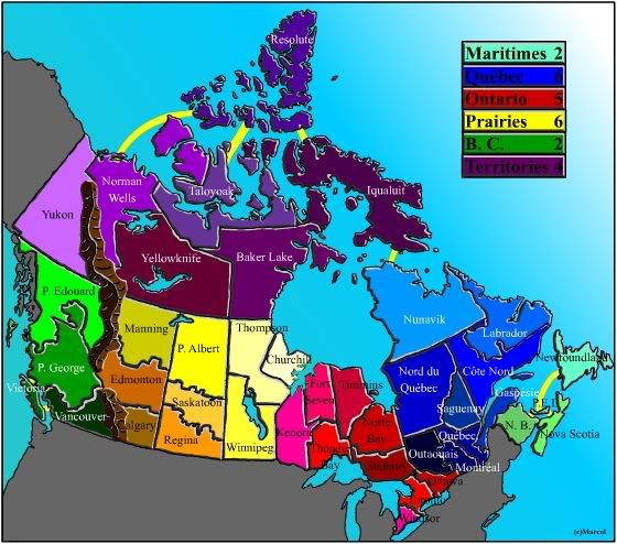
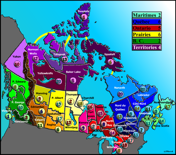
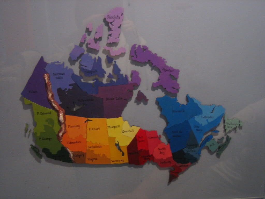
On another note, I also built a map to play with my friends. It is not completely finished, its still missing the background. You can go see it here:

http://i45.photobucket.com/albums/f80/supermarcol/risk1.jpg

http://i45.photobucket.com/albums/f80/supermarcol/risk2.jpg

Thanks for all of your suggestions; thanks to all my friends who played with me on it; and a very, very special thanks to my girlfriend who helped (as in did 90% of) building my board.

Lack, I'm waiting to hear from you :mrgreen: !
Last edited by supermarcol on Thu Mar 02, 2006 12:22 am, edited 1 time in total.
-SuperMarcol
User avatar
Marvaddin
Posts: 2545
Joined: Thu Feb 09, 2006 5:06 pm
Location: Belo Horizonte, Brazil

Post by Marvaddin »

I can only see a red "X".
User avatar
Risk_06
Posts: 159
Joined: Wed Jan 18, 2006 8:33 pm
Location: BC, Canada.
Contact:

Post by Risk_06 »

Yeah, same with me...the website links don't work. :?
Currently on vacation. Sorry.

Proud xiGAMES member!
http://xigames.net/forum
Click it! NOW!
User avatar
supermarcol
Posts: 153
Joined: Mon Jan 30, 2006 7:19 pm
Location: Montreal, Qc

Post by supermarcol »

huh, I think i went over the maximum upload limit for a day, its very small... ill try something else.
-SuperMarcol
User avatar
Risk_06
Posts: 159
Joined: Wed Jan 18, 2006 8:33 pm
Location: BC, Canada.
Contact:

Post by Risk_06 »

Oh, never mind, the links work now, and I can see the picture. Awesome map! :mrgreen:
Currently on vacation. Sorry.

Proud xiGAMES member!
http://xigames.net/forum
Click it! NOW!
User avatar
Marvaddin
Posts: 2545
Joined: Thu Feb 09, 2006 5:06 pm
Location: Belo Horizonte, Brazil

Post by Marvaddin »

Yeah, good map...
Hmmm... Are there only one route between Maritimes and Quebec?
The territories colors arent good. The two islands seems to form another continent...
Oh, and the Pacific waters are green!!
User avatar
supermarcol
Posts: 153
Joined: Mon Jan 30, 2006 7:19 pm
Location: Montreal, Qc

Post by supermarcol »

if you refresh it should be better. And yes, no more 2 entries to the maritimes. Well I should go to bed now, its rather early in this part of the world :P
-SuperMarcol
User avatar
lackattack
Posts: 6097
Joined: Sun Jan 01, 2006 10:34 pm
Location: Montreal, QC

Post by lackattack »

I love it!
supermarcol, this weekend I will open a map maker's forum with instructions on map sizes and how to specify the borders. So please hang on a few more days...
User avatar
supermarcol
Posts: 153
Joined: Mon Jan 30, 2006 7:19 pm
Location: Montreal, Qc

Post by supermarcol »

WOOT
-SuperMarcol
User avatar
thegrimsleeper
Posts: 984
Joined: Thu Jan 26, 2006 10:40 am
Location: Seattle
Contact:

Post by thegrimsleeper »

lackattack wrote:this weekend I will open a map maker's forum with instructions on map sizes and how to specify the borders.


:shock: :D :shock: :D :shock: :D :shock: :D :shock: :D :shock:

SO ready for this one....

My Europe map is very near completion!!!

lack = teh b0mbz0r
User avatar
Marvaddin
Posts: 2545
Joined: Thu Feb 09, 2006 5:06 pm
Location: Belo Horizonte, Brazil

Post by Marvaddin »

My Brazil map is also almost done.
User avatar
kingwaffles
Posts: 718
Joined: Mon Jan 23, 2006 9:05 am
Location: Pseudopolis Yard, Ankh Morpork, Discworld

Post by kingwaffles »

sweetness! I can't wait to play on it :)
Image
User avatar
hockeycapn
Posts: 95
Joined: Tue Jan 31, 2006 11:57 pm
Location: New Hampshire

All the new maps

Post by hockeycapn »

Hell I can't wait to play on any of the new ones. And the quality of the maps you guys are creating is great.
User avatar
Romber
Posts: 193
Joined: Sat Feb 25, 2006 10:52 pm
Gender: Male
Location: Michigan

Post by Romber »

Wait one question about the map. Why is it that Ontario and Quebec are worth the same troops but have the same amount of territories?
I AM TEH RUST
User avatar
max is gr8
Posts: 3720
Joined: Sat Jan 21, 2006 6:44 am
Location: In a big ball of light sent from the future

Post by max is gr8 »

Can you make it easier to see the red country names
User avatar
supermarcol
Posts: 153
Joined: Mon Jan 30, 2006 7:19 pm
Location: Montreal, Qc

Post by supermarcol »

I could change some of the ontario's regions name in white, or move them around a little. And to answer the question about points, its not just the number of region that counts, Ontario has less entry points than quebec, touches only 2 other provinces as opposed to 3 for quebec, and is way more linear which means its easier to conquer. The difference in troops is not that great. I had problems with nobody wanting to get ontario, but with the big ugly river it should fix that. Anyway, if after a couple of weeks of playing people find that its not well balanced, i can modify it. But I am more concerned about the territories than ontario. We'll see how it goes.
-SuperMarcol
User avatar
supermarcol
Posts: 153
Joined: Mon Jan 30, 2006 7:19 pm
Location: Montreal, Qc

Post by supermarcol »

Ok folks, the Canada map is taking shape! This is where I am at now. I still need to do the large version. I know it gets a bit crazy in the southeast with all those places, but I think the large map will show it better. Anyway. Tell me what you think about it!
Image
-SuperMarcol
User avatar
kingwaffles
Posts: 718
Joined: Mon Jan 23, 2006 9:05 am
Location: Pseudopolis Yard, Ankh Morpork, Discworld

Post by kingwaffles »

Beautiful! I can't wait to play!
Image
User avatar
Marvaddin
Posts: 2545
Joined: Thu Feb 09, 2006 5:06 pm
Location: Belo Horizonte, Brazil

Post by Marvaddin »

Yeah, it seems good. Is this the small version?? :shock:

Hmm, the names of North Bay and Outaouais seem be only one.
User avatar
Spiegelprime
Posts: 33
Joined: Sat Feb 04, 2006 4:59 pm

Post by Spiegelprime »

This map is sweet, I'm so excited for all these new maps!
User avatar
thegrimsleeper
Posts: 984
Joined: Thu Jan 26, 2006 10:40 am
Location: Seattle
Contact:

Post by thegrimsleeper »

I love what you've done with the number-dots. They really help to define the character of the map itself. I think this map has come a long way, and it's so close to completion.

If I could make one suggestion: The name sof the continents are still a little hard to read, and it's not very aesthetically pleasing to have different colors.

Are you using a program like Photoshop, where you can blur the text/layer? If so, I think you might do well to create a shadow onto which you could drop the white text. This would allow the names of all the countries to be easily read, as well as keeping them all nice and uniform.

Just my thoughts, other than that I can't wait to play on this map again.
User avatar
supermarcol
Posts: 153
Joined: Mon Jan 30, 2006 7:19 pm
Location: Montreal, Qc

Post by supermarcol »

Yeah I'm having troubles with the names, I had to make them even smaller to fit the numbers in. I sadly can't add shadows to the names unless I do it manually :? and I already did the border of each country manually... it takes a while. I'll try to figure out a way to fix this, I'm thinking something along black edge and white filled names, that way you can see them on any country. I'm having a lot of midterms these days so I can't spend as much time as I want on this. Its not final yet. Still need to do the large one.
-SuperMarcol
User avatar
elebdae
Posts: 43
Joined: Mon Jan 30, 2006 7:42 pm
Location: Montréal, Québec, Canada

Post by elebdae »

Do you still have the intenetion of puting a river between North Bay and Outaouais? It would be easier to hold Ontario, and the map would be a little more balanced...8)

GOOD JOB! And for the record, marcol did a plastic real version of this map ans we played it two weeks ago and it was awesome (and I won too :lol: )
User avatar
supermarcol
Posts: 153
Joined: Mon Jan 30, 2006 7:19 pm
Location: Montreal, Qc

Post by supermarcol »

no river between ontario and quebec, that would make quebec easier to hold. There is a river between the prairies and ontario though. So much sleeping to do and so little time to work on conquerclub map.
-SuperMarcol
User avatar
fishfleas
Posts: 140
Joined: Wed Feb 22, 2006 12:29 pm
Location: Indiana
Contact:

Post by fishfleas »

I like the map.... however.... the colors on the computer screen are a bit bright.... any way to tone it down? make the colors a bit more dull.... that way after hours of staring at what to do you dont' have headaches....


Also, my other suggestion would be, keep the territories within the "countries" the same color or at least alot closer in color than they are right now. As of right now it seems a bit too busy but I think you'll find if you take those color suggestions you'll be really happy with the results. :)
Post Reply

Return to “The Atlas”