Re: [Official] British Isles REVAMP - P1+39[I, GP] [Final Forge]
Posted: Mon Apr 14, 2008 4:07 pm
One small nitpick: the compass in the large version looks a bit blurry. Could you sharpen it a bit?
 Other than that, great job!
Conquer Club, a free online multiplayer variation of a popular world domination board game.
http://www.tools.conquerclub.com/forum2/
http://www.tools.conquerclub.com/forum2/viewtopic.php?t=35649
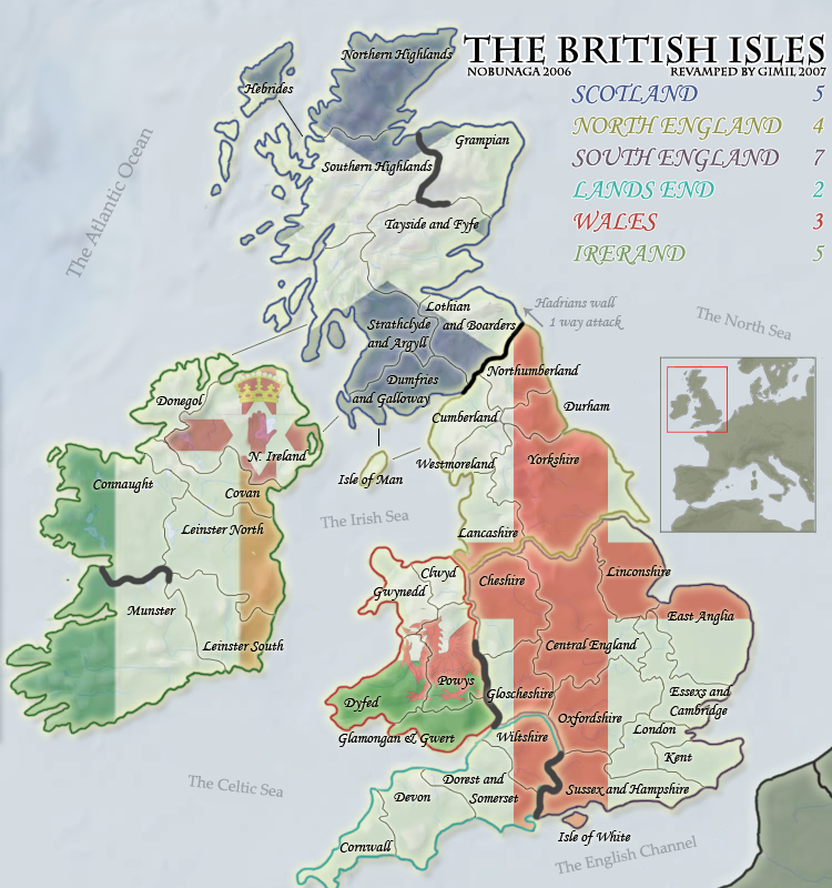
MrBenn wrote:'Gloucester' needs to be 'Gloucestershire'
MrBenn wrote:How about adding a tag to the current map in play to let people know that it is about to be revamped:
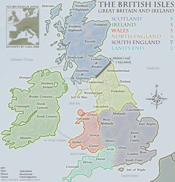
[bigimg]http://www.twogoodpaws.co.uk/conquerclub/britrev.png[/bigimg]
Ruben Cassar wrote:An excellent idea that has been totally ignored. I'm bringing it up again.
gimil wrote:Ruben Cassar wrote:An excellent idea that has been totally ignored. I'm bringing it up again.
Thats a little harsh. If you had read the full thread you would of known that oaktown already brought attention to it backstage
Ruben Cassar wrote:gimil wrote:Ruben Cassar wrote:An excellent idea that has been totally ignored. I'm bringing it up again.
Thats a little harsh. If you had read the full thread you would of known that oaktown already brought attention to it backstage
Ouch my fault then I did not read all the thread.

Still it's a good idea.
Ruben Cassar wrote:MrBenn wrote:How about adding a tag to the current map in play to let people know that it is about to be revamped:
[bigimg]http://www.twogoodpaws.co.uk/conquerclub/britrev.png[/bigimg]
An excellent idea that has been totally ignored. I'm bringing it up again. This should become the de facto standard for every map that is being revamped. It would definitely avoid us the problems created by Classic.
I don't think that British Isles will be a problem because the new version is much more superior to the old one, but it helps to let people who do not visit the foundry know that a revamp is in progress. This might even add more input to the foundry process.
I'd say this one looks even better. Why not use it? Sorry if it's a stupid question, but I haven't been in the map foundry very much.gimil wrote:
CaptainMoo wrote:please dont f*ck up this map like you did on the original
why do u guys keep ruining the flagship maps of this site......if you think its a super new map then release a 2nd version and let people have the choice.......over designing and constant re-thinking are destroying the playability and fun on this sites best maps.
if it aint broke then leave it the f*ck alone.....
apologies for language but after the orginal map was destroyed its been highlighted we have to scour the foundry for future crap and post opinion before its enforced
LEAVE IT ALONE FFS PLEASE
Code: Select all
<?xml version="1.0" ?>
<map>
<title>British Isles</title>
<smallwidth>577</smallwidth>
<smallheight>600</smallheight>
<largewidth>750</largewidth>
<largeheight>780</largeheight>
<filetype>png</filetype>
<continent>
<name>Scotland</name>
<bonus>5</bonus>
<components>
<component>Lothian & Borders</component>
<component>Dumfries & Galloway</component>
<component>Grampian</component>
<component>Hebrides</component>
<component>Northern Highlands</component>
<component>Southern Highlands</component>
<component>Strathclyde</component>
<component>Tayside</component>
</components>
</continent>
<continent>
<name>Ireland</name>
<bonus>5</bonus>
<components>
<component>Munster</component>
<component>South Leinster</component>
<component>North Leinster</component>
<component>Connaught</component>
<component>Border Counties</component>
<component>Northern Ireland</component>
<component>Donegal</component>
</components>
</continent>
<continent>
<name>Wales</name>
<bonus>3</bonus>
<components>
<component>Clwyd</component>
<component>Dyfed</component>
<component>Gwent</component>
<component>Gwynedd</component>
<component>Powys</component>
</components>
</continent>
<continent>
<name>North England</name>
<bonus>4</bonus>
<components>
<component>Cumberland</component>
<component>Durham</component>
<component>Isle Of Man</component>
<component>Lancashire</component>
<component>Northumberland</component>
<component>Westmorland</component>
<component>Yorkshire</component>
</components>
</continent>
<continent>
<name>South England</name>
<bonus>7</bonus>
<components>
<component>West Midlands</component>
<component>Midlands</component>
<component>Lincolnshire</component>
<component>Oxfordshire</component>
<component>Essex & Cambridgeshire</component>
<component>East Anglia</component>
<component>South Coast</component>
<component>London</component>
<component>Kent</component>
<component>Isle of Wight</component>
<component>Glouchester</component>
</components>
</continent>
<continent>
<name>Land's End</name>
<bonus>2</bonus>
<components>
<component>Cornwall</component>
<component>Devon</component>
<component>Dorset</component>
<component>Avon</component>
</components>
</continent>
<territory>
<name>Lothian & Borders</name>
<borders>
<border>Dumfries & Galloway</border>
<border>Strathclyde</border>
<border>Tayside</border>
</borders>
<coordinates>
<smallx>337</smallx>
<smally>230</smally>
<largex>436</largex>
<largey>293</largey>
</coordinates>
</territory>
<territory>
<name>Dumfries & Galloway</name>
<borders>
<border>Lothian & Borders</border>
<border>Isle Of Man</border>
<border>Strathclyde</border>
<border>Northern Ireland</border>
</borders>
<coordinates>
<smallx>297</smallx>
<smally>266</smally>
<largex>387</largex>
<largey>339</largey>
</coordinates>
</territory>
<territory>
<name>Grampian</name>
<borders>
<border>Tayside</border>
</borders>
<coordinates>
<smallx>322</smallx>
<smally>126</smally>
<largex>420</largex>
<largey>157</largey>
</coordinates>
</territory>
<territory>
<name>Hebrides</name>
<borders>
<border>Southern Highlands</border>
</borders>
<coordinates>
<smallx>178</smallx>
<smally>61</smally>
<largex>231</largex>
<largey>75</largey>
</coordinates>
</territory>
<territory>
<name>Northern Highlands</name>
<borders>
<border>Southern Highlands</border>
</borders>
<coordinates>
<smallx>249</smallx>
<smally>79</smally>
<largex>329</largex>
<largey>90</largey>
</coordinates>
</territory>
<territory>
<name>Southern Highlands</name>
<borders>
<border>Hebrides</border>
<border>Northern Highlands</border>
<border>Strathclyde</border>
<border>Tayside</border>
</borders>
<coordinates>
<smallx>238</smallx>
<smally>143</smally>
<largex>314</largex>
<largey>180</largey>
</coordinates>
</territory>
<territory>
<name>Strathclyde</name>
<borders>
<border>Lothian & Borders</border>
<border>Donegal</border>
<border>Dumfries & Galloway</border>
<border>Southern Highlands</border>
<border>Tayside</border>
</borders>
<coordinates>
<smallx>271</smallx>
<smally>231</smally>
<largex>353</largex>
<largey>294</largey>
</coordinates>
</territory>
<territory>
<name>Tayside</name>
<borders>
<border>Lothian & Borders</border>
<border>Grampian</border>
<border>Southern Highlands</border>
<border>Strathclyde</border>
</borders>
<coordinates>
<smallx>281</smallx>
<smally>183</smally>
<largex>369</largex>
<largey>228</largey>
</coordinates>
</territory>
<territory>
<name>South Leinster</name>
<borders>
<border>Dyfed</border>
<border>Munster</border>
<border>North Leinster</border>
</borders>
<coordinates>
<smallx>155</smallx>
<smally>438</smally>
<largex>203</largex>
<largey>563</largey>
</coordinates>
</territory>
<territory>
<name>Donegal</name>
<borders>
<border>Northern Ireland</border>
<border>Strathclyde</border>
<border>Border Counties</border>
</borders>
<coordinates>
<smallx>115</smallx>
<smally>283</smally>
<largex>148</largex>
<largey>364</largey>
</coordinates>
</territory>
<territory>
<name>Connaught</name>
<borders>
<border>Border Counties</border>
<border>North Leinster</border>
</borders>
<coordinates>
<smallx>65</smallx>
<smally>354</smally>
<largex>85</largex>
<largey>455</largey>
</coordinates>
</territory>
<territory>
<name>Northern Ireland</name>
<borders>
<border>Donegal</border>
<border>Dumfries & Galloway</border>
<border>Border Counties</border>
</borders>
<coordinates>
<smallx>171</smallx>
<smally>278</smally>
<largex>223</largex>
<largey>355</largey>
</coordinates>
</territory>
<territory>
<name>Munster</name>
<borders>
<border>South Leinster</border>
</borders>
<coordinates>
<smallx>83</smallx>
<smally>460</smally>
<largex>113</largex>
<largey>581</largey>
</coordinates>
</territory>
<territory>
<name>Border Counties</name>
<borders>
<border>Connaught</border>
<border>North Leinster</border>
<border>Donegal</border>
<border>Northern Ireland</border>
</borders>
<coordinates>
<smallx>107</smallx>
<smally>326</smally>
<largex>140</largex>
<largey>417</largey>
</coordinates>
</territory>
<territory>
<name>North Leinster</name>
<borders>
<border>South Leinster</border>
<border>Border counties</border>
<border>Connaught</border>
</borders>
<coordinates>
<smallx>169</smallx>
<smally>374</smally>
<largex>221</largex>
<largey>480</largey>
</coordinates>
</territory>
<territory>
<name>Clwyd</name>
<borders>
<border>West Midlands</border>
<border>Gwynedd</border>
<border>Lancashire</border>
<border>Powys</border>
</borders>
<coordinates>
<smallx>306</smallx>
<smally>413</smally>
<largex>399</largex>
<largey>530</largey>
</coordinates>
</territory>
<territory>
<name>Dyfed</name>
<borders>
<border>South Leinster</border>
<border>Gwent</border>
<border>Gwynedd</border>
<border>Powys</border>
</borders>
<coordinates>
<smallx>275</smallx>
<smally>483</smally>
<largex>353</largex>
<largey>621</largey>
</coordinates>
</territory>
<territory>
<name>Gwent</name>
<borders>
<border>Dyfed</border>
<border>Powys</border>
</borders>
<coordinates>
<smallx>303</smallx>
<smally>515</smally>
<largex>395</largex>
<largey>663</largey>
</coordinates>
</territory>
<territory>
<name>Gwynedd</name>
<borders>
<border>Clwyd</border>
<border>Dyfed</border>
<border>Powys</border>
</borders>
<coordinates>
<smallx>284</smallx>
<smally>428</smally>
<largex>370</largex>
<largey>550</largey>
</coordinates>
</territory>
<territory>
<name>Powys</name>
<borders>
<border>West Midlands</border>
<border>Clwyd</border>
<border>Dyfed</border>
<border>Gwent</border>
<border>Gwynedd</border>
</borders>
<coordinates>
<smallx>306</smallx>
<smally>447</smally>
<largex>401</largex>
<largey>580</largey>
</coordinates>
</territory>
<territory>
<name>Cumberland</name>
<borders>
<border>Durham</border>
<border>Dumfries & Galloway</border>
<border>Isle Of Man</border>
<border>Northumberland</border>
<border>Westmorland</border>
<border>Lothian & Borders</border>
</borders>
<coordinates>
<smallx>306</smallx>
<smally>306</smally>
<largex>398</largex>
<largey>394</largey>
</coordinates>
</territory>
<territory>
<name>Durham</name>
<borders>
<border>Cumberland</border>
<border>Northumberland</border>
<border>Westmorland</border>
<border>Yorkshire</border>
</borders>
<coordinates>
<smallx>372</smallx>
<smally>294</smally>
<largex>482</largex>
<largey>377</largey>
</coordinates>
</territory>
<territory>
<name>Isle Of Man</name>
<borders>
<border>Dumfries & Galloway</border>
<border>Cumberland</border>
</borders>
<coordinates>
<smallx>256</smallx>
<smally>326</smally>
<largex>336</largex>
<largey>415</largey>
</coordinates>
</territory>
<territory>
<name>Lancashire</name>
<borders>
<border>West Midlands</border>
<border>Clwyd</border>
<border>Midlands</border>
<border>Westmorland</border>
<border>Yorkshire</border>
</borders>
<coordinates>
<smallx>328</smallx>
<smally>358</smally>
<largex>428</largex>
<largey>458</largey>
</coordinates>
</territory>
<territory>
<name>Northumberland</name>
<borders>
<border>Lothian & Borders</border>
<border>Cumberland</border>
<border>Durham</border>
</borders>
<coordinates>
<smallx>349</smallx>
<smally>274</smally>
<largex>455</largex>
<largey>350</largey>
</coordinates>
</territory>
<territory>
<name>Westmorland</name>
<borders>
<border>Cumberland</border>
<border>Durham</border>
<border>Lancashire</border>
<border>Yorkshire</border>
</borders>
<coordinates>
<smallx>327</smallx>
<smally>316</smally>
<largex>426</largex>
<largey>402</largey>
</coordinates>
</territory>
<territory>
<name>Yorkshire</name>
<borders>
<border>Durham</border>
<border>Lancashire</border>
<border>Lincolnshire</border>
<border>Midlands</border>
<border>Westmorland</border>
</borders>
<coordinates>
<smallx>385</smallx>
<smally>354</smally>
<largex>502</largex>
<largey>454</largey>
</coordinates>
</territory>
<territory>
<name>West Midlands</name>
<borders>
<border>Clwyd</border>
<border>Lancashire</border>
<border>Midlands</border>
<border>Powys</border>
<border>Glouchester</border>
</borders>
<coordinates>
<smallx>342</smallx>
<smally>399</smally>
<largex>446</largex>
<largey>512</largey>
</coordinates>
</territory>
<territory>
<name>East Anglia</name>
<borders>
<border>Essex & Cambridgeshire</border>
<border>Lincolnshire</border>
</borders>
<coordinates>
<smallx>487</smallx>
<smally>455</smally>
<largex>634</largex>
<largey>585</largey>
</coordinates>
</territory>
<territory>
<name>Essex & Cambridgeshire</name>
<borders>
<border>East Anglia</border>
<border>Oxfordshire</border>
<border>Lincolnshire</border>
<border>London</border>
<border>Midlands</border>
</borders>
<coordinates>
<smallx>467</smallx>
<smally>484</smally>
<largex>608</largex>
<largey>623</largey>
</coordinates>
</territory>
<territory>
<name>Oxfordshire</name>
<borders>
<border>Essex & Cambridgeshire</border>
<border>London</border>
<border>Midlands</border>
<border>Glouchester</border>
<border>Avon</border>
<border>South Coast</border>
</borders>
<coordinates>
<smallx>400</smallx>
<smally>484</smally>
<largex>521</largex>
<largey>623</largey>
</coordinates>
</territory>
<territory>
<name>Isle of Wight</name>
<borders>
<border>South Coast</border>
</borders>
<coordinates>
<smallx>395</smallx>
<smally>580</smally>
<largex>515</largex>
<largey>747</largey>
</coordinates>
</territory>
<territory>
<name>Kent</name>
<borders>
<border>London</border>
<border>South Coast</border>
</borders>
<coordinates>
<smallx>490</smallx>
<smally>530</smally>
<largex>638</largex>
<largey>682</largey>
</coordinates>
</territory>
<territory>
<name>Lincolnshire</name>
<borders>
<border>East Anglia</border>
<border>Essex & Cambridgeshire</border>
<border>Midlands</border>
<border>Yorkshire</border>
</borders>
<coordinates>
<smallx>430</smallx>
<smally>409</smally>
<largex>560</largex>
<largey>525</largey>
</coordinates>
</territory>
<territory>
<name>London</name>
<borders>
<border>Essex & Cambridgeshire</border>
<border>Oxfordshire</border>
<border>Kent</border>
<border>South Coast</border>
</borders>
<coordinates>
<smallx>440</smallx>
<smally>513</smally>
<largex>569</largex>
<largey>662</largey>
</coordinates>
</territory>
<territory>
<name>Midlands</name>
<borders>
<border>West Midlands</border>
<border>Essex & Cambridgeshire</border>
<border>Oxfordshire</border>
<border>Lancashire</border>
<border>Lincolnshire</border>
<border>Glouchester</border>
<border>Yorkshire</border>
</borders>
<coordinates>
<smallx>393</smallx>
<smally>426</smally>
<largex>512</largex>
<largey>547</largey>
</coordinates>
</territory>
<territory>
<name>Glouchester</name>
<borders>
<border>West Midlands</border>
<border>Midlands</border>
<border>Oxforshire</border>
<border>Avon</border>
</borders>
<coordinates>
<smallx>350</smallx>
<smally>467</smally>
<largex>456</largex>
<largey>601</largey>
</coordinates>
</territory>
<territory>
<name>South Coast</name>
<borders>
<border>Oxfordshire</border>
<border>Isle of Wight</border>
<border>Kent</border>
<border>London</border>
</borders>
<coordinates>
<smallx>398</smallx>
<smally>547</smally>
<largex>519</largex>
<largey>704</largey>
</coordinates>
</territory>
<territory>
<name>Cornwall</name>
<borders>
<border>Devon</border>
</borders>
<coordinates>
<smallx>253</smallx>
<smally>587</smally>
<largex>330</largex>
<largey>757</largey>
</coordinates>
</territory>
<territory>
<name>Devon</name>
<borders>
<border>Cornwall</border>
<border>Dorset</border>
</borders>
<coordinates>
<smallx>282</smallx>
<smally>577</smally>
<largex>368</largex>
<largey>744</largey>
</coordinates>
</territory>
<territory>
<name>Dorset</name>
<borders>
<border>Devon</border>
<border>Avon</border>
</borders>
<coordinates>
<smallx>344</smallx>
<smally>563</smally>
<largex>448</largex>
<largey>725</largey>
</coordinates>
</territory>
<territory>
<name>Avon</name>
<borders>
<border>Dorset</border>
<border>Glouchester</border>
<border>Oxforshire</border>
</borders>
<coordinates>
<smallx>362</smallx>
<smally>531</smally>
<largex>470</largex>
<largey>680</largey>
</coordinates>
</territory>
</map>