Page 22 of 39
Posted: Fri Jan 25, 2008 8:01 am
by Ogrecrusher
New colours rule over old ones.
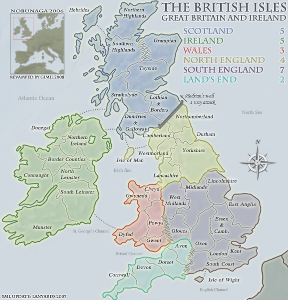
Also, being born in Wales and living there for most of my life, I know that Dyfed doesn't exist anymore. Maybe you don't mind about this, it's historical and includes Hadrian's wall after all, but it seems a little weird to me.
I'd suggest Pembrokeshire or Carmarthenshire.

Edit number 2:
I think the impassables should be replaced where possible with real or exaggerated geograpical features. You've already done this with the Shannon in Ireland, but I believe someone else suggested the new forest for the Land's end impassable, and what about the River Severn for the Wales one?
Finally, you really could make the river Shannon look more like a river and less like a careless dragging of the mouse

Looking good!
Posted: Fri Jan 25, 2008 10:47 am
by iancanton
of the current welsh territories, only powys covers the same area as the current councils. the others mostly follow the boundaries as they were from 1975-1995, which is also the case for scotland. the advantage of using the 1975 areas is that the number of regions in wales and scotland is roughly equal to the number of welsh and scottish territories on this map, so that fewer places are left out.
the welsh impassable could be offa's dyke. i think it's unnamed on the original map because it's not a one-way attack route or anything else unusual.
http://www.cpat.org.uk/offa/what.htm
ian.

Posted: Fri Jan 25, 2008 4:49 pm
by pepperonibread
Can Cumberland attack Lothian & Borders? You might want to change the borders slightly to clarify this.
Posted: Fri Jan 25, 2008 6:58 pm
by wrightfan123
I checked the XML. They don't.
Posted: Tue Feb 05, 2008 2:58 am
by t.e.c
i'm sure this has been said, but i like the colors on the current map a lot more than this version.
Posted: Tue Feb 05, 2008 7:39 am
by MrBenn
<poke>
Gimil, have you got another update for us yet? It's been over a month!

Posted: Tue Feb 05, 2008 11:07 am
by gimil
MrBenn wrote:<poke>
Gimil, have you got another update for us yet? It's been over a month!
Ive put this one on hold for now
WM is going to make me some impassables at some point, then ill restart it
Posted: Mon Feb 11, 2008 9:00 am
by Wisse
not sure if already said (sorry if it is)
but the unplayable land seems to have to much attention, you can better tone the borders a bit down to make them gray (and maybe even remove the border between the two country's there)
Posted: Mon Feb 11, 2008 12:18 pm
by McStick
Should that not be "Cavan" instead of Covan?!
Posted: Mon Feb 11, 2008 7:39 pm
by sfhbballnut
I like this a lot, I thought this map was pretty good, but seeing it now it was well worth the effort to re do it
Posted: Mon Feb 11, 2008 10:26 pm
by jako
gimil, u need to check the hadrien's wall borders. it looks like there is a four ways thing going on cause im not sure of northumberland can attack gallows or cumberland can attack borders.
Posted: Thu Feb 21, 2008 12:09 pm
by emma_juli
love ths map!!!
Posted: Sun Feb 24, 2008 3:49 pm
by gimil
oK I went thorught te thread and addressed every issues except the unpassables, those this be addressed eventually

I just want to know if there is any further concerns before I restart the large version.
Posted: Sun Feb 24, 2008 3:58 pm
by pepperonibread
One quick thing.
I don't think Northumberland can attack Dumfries & Galloway, and if it doesn't, maybe you could scoot the Northumberland-Cumberland border right a pixel or two to clarify this.
Posted: Sun Feb 24, 2008 4:12 pm
by gimil
pepperonibread wrote:One quick thing.
I don't think Northumberland can attack Dumfries & Galloway, and if it doesn't, maybe you could scoot the Northumberland-Cumberland border right a pixel or two to clarify this.
I plan to counter this issue with one way attack arrows over hadrians wall from Northumberland to Lothian and Boarders and Cumberland to Dumfries and galloway.
Posted: Sun Feb 24, 2008 6:05 pm
by Lone.prophet
no need for the arrows i think just make the borders clearens a bit more
Posted: Sun Feb 24, 2008 6:10 pm
by pepperonibread
That wouldn't really work, because then someone might think Cumberland can attack Lothian & Borders.
Posted: Sun Feb 24, 2008 7:16 pm
by gimil
Lone.prophet wrote:no need for the arrows i think just make the borders clearens a bit more
With a 4 way border?
Posted: Mon Feb 25, 2008 6:03 pm
by Risktaker17
I like the map without the flags
Posted: Wed Feb 27, 2008 8:33 am
by iancanton
gimil
u have tried very hard, largely successfully, to keep the territory boundaries consistent with actual county boundaries (not the easiest job when ur hands are tied by keeping the same gameplay). the only boundary issue remaining here is location of the west midlands: the whole of the west midlands territory needs to be moved down by one county.
http://www.advantagewm.co.uk/the-west-midlands-region/
west midlands just now: shropshire, staffordshire and cheshire excluding wirral
west midlands proposed: official definition, being shropshire, staffordshire, herefordshire, worcestershire and warwickshire, with impassable hills (cotswolds) between warwickshire and oxon
lancashire just now: lancashire and wirral
lancashire proposed: lancashire and whole of cheshire (because cheshire is a north of england county – ever watched hollyoaks?)
midlands just now: contains warwickshire, which makes territory a very odd shape
midlands proposed: remove warwickshire
gloucs just now: gloucs, herefordshire and worcestershire
gloucs proposed: gloucs
unstick the isle of anglesey from gwynedd.
key for abbreviations of long names like gloucestershire, oxfordshire and possibly dumfries & galloway.
is land’s end to keep the same name or be renamed west of england, wessex or something else? i don’t think this was ever resolved. land’s end is the name of only a tiny part of one of the territories in the continent, though it is one of the original author’s idiosyncrasies that some players might like to retain as a homage to the old map.
ian.
Posted: Wed Feb 27, 2008 1:15 pm
by gimil
f*ck me ian, what a way t okeep me busy
Posted: Tue Mar 25, 2008 10:00 pm
by WidowMakers
Why is this map not done yet. This image looks great. What were the issues with it?
It is easy to read, good colors, nice style. What is the trouble?

Posted: Wed Mar 26, 2008 12:49 am
by hulmey
my only issue with this map, is that i think hadrian's wall could look alot sweeter!
Posted: Wed Mar 26, 2008 12:54 am
by lord voldemort
i think hadrians wall + the territories around it could be done better
ie
is it possible to attack cumberland ----> lothian & borders
and Northumberland ----> dumfries & Galloway
plus the wall could be more prominent perhaps
Posted: Wed Mar 26, 2008 12:56 am
by edbeard
I agree with the last two posts
yes the last TWO
I'd be in favour of giving the wall a bit more depth to get more detail in there.