Scandinavia Map

Have an idea for a map? Discuss ideas and concepts here.

Moderator: Cartographers

Forum rules
Please read the Community Guidelines before posting.
User avatar
happysadfun
Posts: 1251
Joined: Mon Jul 10, 2006 9:06 pm
Location: Haundin at DotSco, Being Sad that Mark Green Lost in Suburban Wisconsin

Post by happysadfun »

gavin_sidhu wrote:Cant u come up with better names than north and south of countries?

I used my trusty atlas to come up with names.
ImageChildren, this is what happens to hockey players, druggies, and Hillary Clinton.

Rope. Tree. Hillary. Some assembly required.
User avatar
Marvaddin
Posts: 2545
Joined: Thu Feb 09, 2006 5:06 pm
Location: Belo Horizonte, Brazil

Post by Marvaddin »

RexRegis, you are the best for doing this map, please dont quit.

In fact, I would say, about mountains, the following:

1) The region like it is would need unpassable borders, or North Norway and North Sweden would have many borders. If there are no mountains, you can use rivers, or can use nothing, simply a barricade, like I used in Brazil map. I didnt want add mountains and rivers that doesnt exist, so I added simple non-crossable borders.
2) Another option would be having a region that is no part of any country, like merging North region of those countries. Maybe this could be a non actual map, but a map of viking kingdoms, I really dont know, but maybe there is another time in History easier to create the map.

Beyond that, maybe we could have more options for continents, looks like we have an excess of medium ones... almost all have 6 countries.
Image
User avatar
Master Bush
Posts: 2387
Joined: Thu Mar 02, 2006 10:50 pm
Gender: Male

Post by Master Bush »

I'm digging this map. Cant wait to play it.
"You know what they say about Love and War...."
"Yeah, one involves a lot of physical and psychological pain, and the other one's War."
User avatar
RexRegis
Posts: 92
Joined: Thu Aug 17, 2006 12:43 am
Location: Sweden

Post by RexRegis »

Ohh. and for mountains that doesn't exist...
I know that my map didn't copy this realistic, but norway is mountains... :p
and the border between sweden and norway are mountains
Image
coup
Posts: 27
Joined: Sat Jun 10, 2006 2:49 am
Location: Norway

Post by coup »

happysadfun wrote:Image
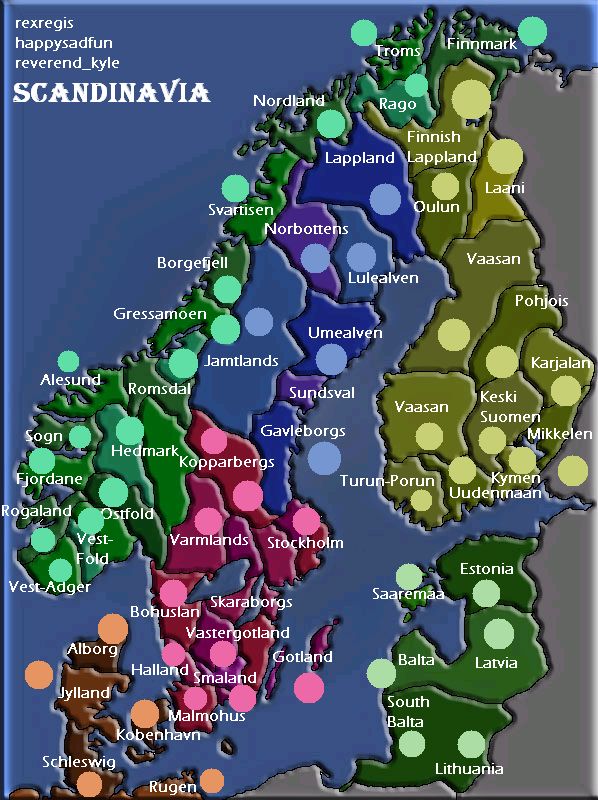
the circles are different sizes, i know, this is just preliminary to verify that these are good colours and positions. if i put a name over a few borders, that means that these countries should be merged.


Hi guys,

sorry that I haven't had the time to drop by, this map is really comming along. About the Norwegian map: the regions is very wrong how they are now. And the names are also wrong on alot of them. Since I could have corrected you guys earlier, I feel the blame are a bit on me. This weekend there are 4 birthday parties to attend to :(, so I'll try to use all my sparetime to help you guys. You've done a lot of good work!
User avatar
RexRegis
Posts: 92
Joined: Thu Aug 17, 2006 12:43 am
Location: Sweden

Post by RexRegis »

Ive done everything on the map in layers so it isn't that hard to fix the regions.

and the map have changed a bit since the one you quoted... didn't I post a updated one?
User avatar
RexRegis
Posts: 92
Joined: Thu Aug 17, 2006 12:43 am
Location: Sweden

Post by RexRegis »

sorry for the double post, but I'm ready to make some changes if I just get some ideas on what to do.
User avatar
Marvaddin
Posts: 2545
Joined: Thu Feb 09, 2006 5:06 pm
Location: Belo Horizonte, Brazil

Post by Marvaddin »

Whats the current map we are talking about?
Image
User avatar
RexRegis
Posts: 92
Joined: Thu Aug 17, 2006 12:43 am
Location: Sweden

Post by RexRegis »

I am talking about this map
Image

but with less mountains, I removed the mountains at the russian border.
and I can easely remove some at the border Sweden/Norway

and the names are the names that happysadfun posted
User avatar
AndyDufresne
Posts: 24935
Joined: Fri Mar 03, 2006 8:22 pm
Location: A Banana Palm in Zihuatanejo
Contact:

Post by AndyDufresne »

One thing you should look into... Continent names other than the simple 'Directional Area' continents. (North Norway, South Sweden, etc). Perhaps you can find some regional names for the areas that you are using as continents.


--Andy
User avatar
RexRegis
Posts: 92
Joined: Thu Aug 17, 2006 12:43 am
Location: Sweden

Post by RexRegis »

Of course...
the names I wrote is just to point out what part is what...
and make some text to know how large the text is.

N.Sweden is Norrland (?)
but I'm very bad at geo... so please help me with the names.
User avatar
happysadfun
Posts: 1251
Joined: Mon Jul 10, 2006 9:06 pm
Location: Haundin at DotSco, Being Sad that Mark Green Lost in Suburban Wisconsin

Post by happysadfun »

N. Norway is Norrland. I'll try to get the names and dots on a layer for you.
ImageChildren, this is what happens to hockey players, druggies, and Hillary Clinton.

Rope. Tree. Hillary. Some assembly required.
User avatar
RexRegis
Posts: 92
Joined: Thu Aug 17, 2006 12:43 am
Location: Sweden

Post by RexRegis »

I know that Norrland is Norrland in swedish wasn't sure about the english term for it.

Thanks for the help with the names...

what do you guys think of the map? is it done? what should be fixed?
mountains? colors? regions? anything... ?
User avatar
Marvaddin
Posts: 2545
Joined: Thu Feb 09, 2006 5:06 pm
Location: Belo Horizonte, Brazil

Post by Marvaddin »

Well, of course its not done... but almost :)

First, why Denmark has some regions that doesnt belong to it in real life?
2nd, would be possible add Iceland? Doing this, maybe we could reposit the legend too, if with that we have a great wasted space.
3rd, if Finland - Russia mountains are not real, remove them, since they are not needed.
4th, I think almost all continents are pretty balanced, we could have some different options. Like, I think you could merge some countries and make Finland a big continent. On other hand, South Norway looks crowded, maybe we can have a smaller continent there...
5th, we need the sea routes.

Think about this, and later we can talk about some more changes, if needed.
Image
User avatar
RexRegis
Posts: 92
Joined: Thu Aug 17, 2006 12:43 am
Location: Sweden

Post by RexRegis »

First, why Denmark has some regions that doesnt belong to it in real life?
2nd, would be possible add Iceland? Doing this, maybe we could reposit the legend too, if with that we have a great wasted space.
3rd, if Finland - Russia mountains are not real, remove them, since they are not needed.
4th, I think almost all continents are pretty balanced, we could have some different options. Like, I think you could merge some countries and make Finland a big continent. On other hand, South Norway looks crowded, maybe we can have a smaller continent there...
5th, we need the sea routes.

1. removed one region
2. iceland added. ( the whole map looks better now IMO, but the scale isn't correct hope you can live with that. )
3. mountains gone.
4. merged some in norway, added iceland.. anymore needed?
5. I made a first draft of where the routes can be.

Image
Oops... forgot the sea routes in danmark...

I hope this doesn't cause to much trouble with the name layer... it shouldn't... it should be just to add the iceland names...
User avatar
onbekende
Posts: 1530
Joined: Fri Apr 14, 2006 10:19 am
Location: Belgium

Post by onbekende »

Looks nice, but since when is Iceland that big?
Emperor of the Benelux
Founder of the Commonwealth of Planets
Founder and CEO of JF
User avatar
reverend_kyle
Posts: 9250
Joined: Tue Mar 21, 2006 4:08 pm
Location: 1000 post club
Contact:

Post by reverend_kyle »

I cant live with iceland not being to scale.
DANCING MUSTARD FOR POOP IN '08!
User avatar
RexRegis
Posts: 92
Joined: Thu Aug 17, 2006 12:43 am
Location: Sweden

Post by RexRegis »

ok ok, when I look at it I see that I can scale it down a little bit more...
but it is still gonna be a bit larger then the real size...
Or... I can make the famouse cut in... place it in a box to show that it isn't real size and place for it.
User avatar
reverend_kyle
Posts: 9250
Joined: Tue Mar 21, 2006 4:08 pm
Location: 1000 post club
Contact:

Post by reverend_kyle »

nah just shrink it a little.. so its not too noticeable.
DANCING MUSTARD FOR POOP IN '08!
User avatar
RexRegis
Posts: 92
Joined: Thu Aug 17, 2006 12:43 am
Location: Sweden

Post by RexRegis »

I made Iceland a bit smaller and I made Finland one continent.

Image
User avatar
AndrewLC
Posts: 661
Joined: Mon Mar 20, 2006 11:19 pm
Location: Richland WA (But Originally from England)
Contact:

Post by AndrewLC »

On the key, Iceland is spelt "Island", just wanted to point it out :D
Sexy party

Free Norse!
Free Norse!
Free Norse!
User avatar
RexRegis
Posts: 92
Joined: Thu Aug 17, 2006 12:43 am
Location: Sweden

Post by RexRegis »

the legend is still in development, but thanks for pointing it out...
spelled it the swedish way.
User avatar
reverend_kyle
Posts: 9250
Joined: Tue Mar 21, 2006 4:08 pm
Location: 1000 post club
Contact:

Post by reverend_kyle »

all of the continents having the same bonus is ghey.... create some diversity.
DANCING MUSTARD FOR POOP IN '08!
User avatar
Marvaddin
Posts: 2545
Joined: Thu Feb 09, 2006 5:06 pm
Location: Belo Horizonte, Brazil

Post by Marvaddin »

He said, the legend is in development...
Anyway, some things...
Did you try Iceland in its natural size? Would it be much smaller? Because if it wouldnt, maybe its not necessary make it bigger.
I was the one that suggested Finland as a single continent, but I was not suggesting it missing that much territories... In fact, I think all map should have at least one big continent, and with 8 continents, at least one could be a gigantic one... this brings more possibilities in strategies, I think. In this map, the country dispersion, if I didnt miscounted, is 5, 5, 5, 5, 6, 6, 7, 8 (hmm, 47?). Maybe we could have some continents with even less countries (the classical continent with 4 countries and 2 borders - Denmark looks perfect!), or more, like 10-11... hmmm, a single Norway, maybe??
And, maybe we are forgeting some countries... the thin island near S. Sweden east coast, that island in Baltics...arent these countries? When will we have the names?
Image
User avatar
RexRegis
Posts: 92
Joined: Thu Aug 17, 2006 12:43 am
Location: Sweden

Post by RexRegis »

Ahh. ok...
I can add the borders to finland again, I just painted over them so they are actually still there.
I'm not sure of how small iceland actually is, but I can shrink it a little more and remove one part of it so it is a 4 land isle.

I can add lines so Öland(small swedish island) and the baltic island is own parts.
and I'll remove one border in danmark so we get fewer parts there.

I don't really like the idea of a single norway, to many border, to long and the only continent that border Iceland

*edit*
here are the changes
Image
the legend now shows the number of regions in the "continent" this is NOT gonna be the bonuses later.

Ohh. and what are you thinking about the baltics being part of scandinavia?
for me it doesn't matter it makes the map more playable for me, but I could remove the baltics and draw a sea route from danmark to finland instead.
Post Reply

Return to “Melting Pot: Map Ideas”