i have not read all these posts so i dont know if these comments have been brought up, and you may be currently working on some of these ideas,
1. Are wales, Scotland, and some of the other larger territories going to be split up into more then one territory?
2. What is with the weird water? I think you can do something much better then that.
3. This may be a stupid question but what is the "green and pleasant land" under England mean?
4. is the land in the bottom right corner going to be played on? If not i think it should be more of a different color then the rest of the map, like gray or something
This is all for now, i will diffidently be back later, i think this could come to be a great map and start a bunch of new themed tournaments
sorry if some of these questions are stupid
England Map [Quenched]
Moderator: Cartographers
Forum rules
Please read the Community Guidelines before posting.
Please read the Community Guidelines before posting.
-
the.killing.44

- Posts: 4724
- Joined: Thu Oct 23, 2008 7:43 pm
- Gender: Male
- Location: now tell me what got two gums and knows how to spit rhymes
- Contact:
Re: England Map - Update p3
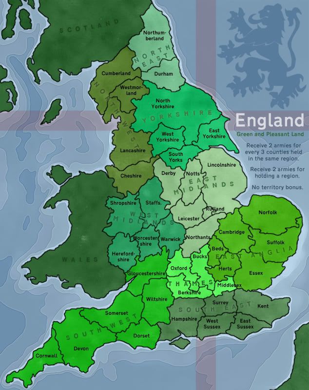
Wales, Scotland, and Calais (the area across the English Channel) are not playable … and Green and Pleasant Land is some sort of motto, no?
Water looks sweet, IMHO Honestly, I'd give this Adv. Draft as it is.
.44
Water looks sweet, IMHO
.44
-
Pedronicus
- Posts: 2080
- Joined: Tue Jan 24, 2006 2:42 pm
- Gender: Male
- Location: Busy not shitting you....
Re: England Map - Update p3
no greater london?


Re: England Map - Update p3
This looks great ben 
1) Love how u did the waters (would love a tutorial on how ), but is there any chance you could lower the opacity of the flag or whatever behind it?its kinda distracting and makes the water seem off IMO
2) Some terit names run into their borders (rutland, worcester, northants, middlesex) and just annoys me... dont need to fix if u dont want to, small thing
3) Is there room for armies on Rutland and Middlesex?
4) What do u mean by 'No Territory Bonus'? It makes me think that I only get +3 for terits no matter what, but Im not sure. Could be explained a bit more, or made clearer
I seem to have run out of things to comment on.. . This looks great
1) Love how u did the waters (would love a tutorial on how
2) Some terit names run into their borders (rutland, worcester, northants, middlesex) and just annoys me... dont need to fix if u dont want to, small thing
3) Is there room for armies on Rutland and Middlesex?
4) What do u mean by 'No Territory Bonus'? It makes me think that I only get +3 for terits no matter what, but Im not sure. Could be explained a bit more, or made clearer
I seem to have run out of things to comment on.. . This looks great
-
sailorseal

- Posts: 2735
- Joined: Sun May 25, 2008 1:49 pm
- Gender: Male
- Location: conquerclub.com
Re: England Map - Update p3
the.killing.44 wrote:Wales, Scotland, and Calais (the area across the English Channel) are not playable … and Green and Pleasant Land is some sort of motto, no?
Water looks sweet, IMHO
.44
I agree I think its ready
-
SuicidalSnowman

- Posts: 1022
- Joined: Fri Aug 22, 2008 7:40 am
- Gender: Male
Re: England Map - Update p3
I think the bonus amounts sound about right.
When I think back to the history of England, most early wars were simply marched across it, as much of England is rolling fields. Heck, the Romans had to build a wall to try and have some sort of fortifications. So I think the openness works very well.
Also, upon closer inspection, the flag background is most distracting (to me) in the lower left, under the water detail. My guess would be either
1) take out the water detail or
2) only have the flag in the upper right
but I am not a cartographer!
Cheers!

Re: England Map - Update p3
Thanks for the feedback and comments
Here's my response to comments so far...
lostatlimbo: Maybe some of England's major rivers to break up the territories a bit?
MrBenn: The problem with our rivers is that they tend to go through the middle of counties, and the region groupings don't fit neatly into areas bordered by rivers. The more I think about it, the more I'm inclined to leave the map wide open... The bonus structure I'm working towards is fairly fluid and should open up a heap of strategies (hopefully).
tlane: Are wales, Scotland, and some of the other larger territories going to be split up into more then one territory?
Pedronicus: no greater london?
MrBenn: The named territories are the traditional English Counties. I've already split Yorkshire up into it's administrative regions, and I envisage the rest staying how they are. Wales, Scotland, and France are not playable areas. London covers much of Middlesex, and overlaps Surrey, Herts, Kent and Essex... The primary focus I'm going for is the English Counties... is Greater London goes on, what about Greater Manchester, or West Midlands? I'm inclined to leave them off, and stick with something simple.
tlane: What is with the weird water? I think you can do something much better then that.
the.killing.44: Water looks sweet, IMHO
bryguy: Love how u did the waters (would love a tutorial on how )
MrBenn: The darker blue is deeper water than the lighter blue... In general I like the effect, although I do think it could be tidied up a bit in the Irish Sea.
bryguy: Is there any chance you could lower the opacity of the flag or whatever behind it?its kinda distracting and makes the water seem off IMO
MrBenn: Are you referring to the red lions or the 'Lion Rampant'? The main problem with the red lines is that they lose their colour if I make them too transparent.... I'll see if I can tweak them a little bit. As for the lion, I've already changed the sea beneath it...
tlane: This may be a stupid question but what is the "green and pleasant land" under England mean?
MrBenn: Jerusalem, by William Blake (1804), is a poem/song that is now an iconic English Anthem (albeit with strange theology). The last verse of it goes "I will not cease from mental fight / Nor shall my sword sleep in my hand / Till we have built Jerusalem / In England's green and pleasant land."
tlane: is the land in the bottom right corner going to be played on? If not i think it should be more of a different color then the rest of the map, like gray or something
MrBenn: That's France.... a historical English adversary that is not a playable area.
bryguy: Some terit names run into their borders (rutland, worcester, northants, middlesex) and just annoys me... dont need to fix if u dont want to, small thing Is there room for armies on Rutland and Middlesex?
MrBenn: The names are there as placeholders - I think the biggest job will be to get all the names to fit properly - and to explain any abbreviations where I've used them. (ie Northants=Northamptonshire)
bryguy: What do u mean by 'No Territory Bonus'? It makes me think that I only get +3 for terits no matter what, but Im not sure. Could be explained a bit more, or made clearer
MrBenn: You're right - 'No territory bonus' means that you won't get more armies for holding more territories (unless they make up bonuses). The minimum deployment will be set and fixed, probably at 2 or 3 armies.
Here's my response to comments so far...
lostatlimbo: Maybe some of England's major rivers to break up the territories a bit?
MrBenn: The problem with our rivers is that they tend to go through the middle of counties, and the region groupings don't fit neatly into areas bordered by rivers. The more I think about it, the more I'm inclined to leave the map wide open... The bonus structure I'm working towards is fairly fluid and should open up a heap of strategies (hopefully).
tlane: Are wales, Scotland, and some of the other larger territories going to be split up into more then one territory?
Pedronicus: no greater london?
MrBenn: The named territories are the traditional English Counties. I've already split Yorkshire up into it's administrative regions, and I envisage the rest staying how they are. Wales, Scotland, and France are not playable areas. London covers much of Middlesex, and overlaps Surrey, Herts, Kent and Essex... The primary focus I'm going for is the English Counties... is Greater London goes on, what about Greater Manchester, or West Midlands? I'm inclined to leave them off, and stick with something simple.
tlane: What is with the weird water? I think you can do something much better then that.
the.killing.44: Water looks sweet, IMHO
bryguy: Love how u did the waters (would love a tutorial on how
MrBenn: The darker blue is deeper water than the lighter blue... In general I like the effect, although I do think it could be tidied up a bit in the Irish Sea.
bryguy: Is there any chance you could lower the opacity of the flag or whatever behind it?its kinda distracting and makes the water seem off IMO
MrBenn: Are you referring to the red lions or the 'Lion Rampant'? The main problem with the red lines is that they lose their colour if I make them too transparent.... I'll see if I can tweak them a little bit. As for the lion, I've already changed the sea beneath it...
tlane: This may be a stupid question but what is the "green and pleasant land" under England mean?
MrBenn: Jerusalem, by William Blake (1804), is a poem/song that is now an iconic English Anthem (albeit with strange theology). The last verse of it goes "I will not cease from mental fight / Nor shall my sword sleep in my hand / Till we have built Jerusalem / In England's green and pleasant land."
tlane: is the land in the bottom right corner going to be played on? If not i think it should be more of a different color then the rest of the map, like gray or something
MrBenn: That's France.... a historical English adversary that is not a playable area.
bryguy: Some terit names run into their borders (rutland, worcester, northants, middlesex) and just annoys me... dont need to fix if u dont want to, small thing
MrBenn: The names are there as placeholders - I think the biggest job will be to get all the names to fit properly - and to explain any abbreviations where I've used them. (ie Northants=Northamptonshire)
bryguy: What do u mean by 'No Territory Bonus'? It makes me think that I only get +3 for terits no matter what, but Im not sure. Could be explained a bit more, or made clearer
MrBenn: You're right - 'No territory bonus' means that you won't get more armies for holding more territories (unless they make up bonuses). The minimum deployment will be set and fixed, probably at 2 or 3 armies.

PB: 2661 | He's blue... If he were green he would die | No mod would be stupid enough to do that

England Map
wow looks good i think the fisst one looks the best
Re: England Map - Update p3
$t0kA wrote:wow looks good i think the fisst one looks the best
Thanks
Which draft are you referring to exactly?
PB: 2661 | He's blue... If he were green he would die | No mod would be stupid enough to do that
Re: England Map - Update p3
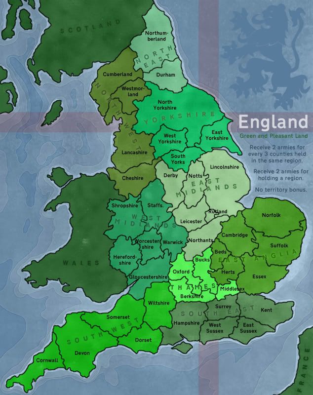
MrBenn wrote:Version 4
Either you skipped V3, or you decided its an unneeded version
thats on p1 btw
Re: England Map - Update p3
v3 is about the 3rd post down on page 2... I never added it to the first post... and I was never that sold on breaking up the regions...
PB: 2661 | He's blue... If he were green he would die | No mod would be stupid enough to do that
-
Merciless Wong
- Posts: 199
- Joined: Wed Feb 06, 2008 8:12 pm
Re: England Map - Update p3
Just a thought. What made Classic so good was that it was:
1) Balanced bonuses size varies with how hard it was to take a continent
2) Had bottlenecks that caused conflict and not static play. E.g. Ukraine and Middle East were a natural defensive position for Europe causing a potential conflict between Europe and Asia.
3) Had niche positions with +2 bonus to start from versus +5 bonus, so you could make the decision between small and easy or large and hard region to target
This is pretty but has none of those features.
-
sailorseal
- Posts: 2735
- Joined: Sun May 25, 2008 1:49 pm
- Gender: Male
- Location: conquerclub.com
Re: England Map - Update p3
So here is what I think. Mostly they are orginizational suggestions but I still feel they are important. Nice map can't wait to play it
I made a list for easy navigation:
1. North East should be excluded from the "+2 for holding a region" because
A. it is easy to start out with
B. It is only two territories and not worth a +2
2. Change the color in East Angelia
3. Move the word Middlesex up and to the left so you have room for a army count and to make it easier to read
4. Move the word Devon to above South West to leave space for a srmy count
5. Move Oxford up for the same reasons
6. Think about eliminating Rutland for it is making things crowded over there and there seems so be no room for it
7. Move Notts and East Midland up to leave room for a army count
8. The Island below Hampshire bothers me, I would make it a territory or eliminate it or just move it further down
-
LED ZEPPELINER
- Posts: 1088
- Joined: Tue Nov 25, 2008 10:09 pm
Re: England Map - Update p3
the problem with moving the names of regions, is that they are placed now so that none of the letters rest on a border/line, if moved, it will be harder to read
sailorseal wrote:My big boy banana was out the whole time
AndyDufresne wrote:Forever linked at the hip's-banana! (That sounds strange, don't quote me.)AndyDufresne wrote:Many Happy Bananas to everyone, lets party...with Bananas.
--Andy
Re: England Map - Update p3 - Gameplay discussion
Merciless Wong, thanks for the comment. Classic gameplay is going to be hard to emulate, as I think I'm deliberately going for an open and exposed map... There's a possibility that I may restrict movement a bit, but for now I'd like to try and keep it open.
sailorseal, the County names will be shifted around a lot to accommodate army numbers and consistent naming, and I can easily tweak the colours a bit if required; but I'm not too worried about that right now - I'd rather get some feedback about the bonus structure
edit: bumping the image to the end:
PB: 2661 | He's blue... If he were green he would die | No mod would be stupid enough to do that

Re: England Map - Gameplay discussion p5
i was sure isle of man or isle of wight was part of england (which ever the south one is and possibly west one as well but unsure bout that) am i right in assuming this ad have you decided to leave them out on purpose as i'd just like to clear this issue up.

Re: England Map - Gameplay discussion p5
Very nice looking map MrBenn, I do have a question about the bonus....
Seems to me that holding south west would be unbalanced if it was an equal bonus as other regions.
- East Midland
- 6 territories = +4
- Region = +2
- Total = +6
- Territories to defend = 5
- East Anglia
- 6 territories = +4
- Region = +2
- Total = +6
- Territories to defend = 5
- South West
- 6 territories = +4
- Region = +2
- Total = +6
- Territories to defend = 3
Seems to me that holding south west would be unbalanced if it was an equal bonus as other regions.

Re: England Map - Gameplay discussion p5
Would moving Gloucestershire into the West Midlands region help balance it out a bit... This would have the effect of bumping West Mids to +6, and knocking South West down to +5...
PB: 2661 | He's blue... If he were green he would die | No mod would be stupid enough to do that
Re: England Map - Gameplay discussion p5
And here's an update with that change...
PB: 2661 | He's blue... If he were green he would die | No mod would be stupid enough to do that
-
LED ZEPPELINER
- Posts: 1088
- Joined: Tue Nov 25, 2008 10:09 pm
Re: England Map - Gameplay discussion p5
i was just wondering how you did the water...i love it 


Re: England Map - Gameplay discussion p5
although it has been mentioned that the british isles is a well-represented area of cc, a typical english county like kent appears on only one other map (british isles, where only half of the territories are part of the area shown on this map), so the requirement for uniqueness is satisfied, especially in conjunction with the "build ur own bonuses" gameplay.
decent feedback has been received from a fair number of people so far and, having had the europa map quenched, u have shown that u have the perseverance to complete a project of this type, though i expect this one to be not nearly so contentious and frustrating.

after u finalise the number of bonus regions that u want, i anticipate that a further quality update will enable the map to be moved to the main foundry.
ian.
decent feedback has been received from a fair number of people so far and, having had the europa map quenched, u have shown that u have the perseverance to complete a project of this type, though i expect this one to be not nearly so contentious and frustrating.
after u finalise the number of bonus regions that u want, i anticipate that a further quality update will enable the map to be moved to the main foundry.
ian.
Re: England Map - Gameplay discussion p5
miniwally wrote:i was sure isle of man or isle of wight was part of england (which ever the south one is and possibly west one as well but unsure bout that) am i right in assuming this ad have you decided to leave them out on purpose as i'd just like to clear this issue up.
Re: England Map - Gameplay discussion p5
The Isle of Man (nearish Cumberland) is a Crown Dependancy. The Queen is the head of state, but the Isle of Man is not part of the UK, nor is it a member of the EU.
I always thought that the Isle of Wight was part of Hampshire, although a quick bit of research indicates that it may in fact be a county in its own right... in which case, it will be named when I next produce an update
I always thought that the Isle of Wight was part of Hampshire, although a quick bit of research indicates that it may in fact be a county in its own right... in which case, it will be named when I next produce an update
PB: 2661 | He's blue... If he were green he would die | No mod would be stupid enough to do that
Re: England Map - Gameplay discussion p5
iancanton wrote:
after u finalise the number of bonus regions that u want, i anticipate that a further quality update will enable the map to be moved to the main foundry.
ian.
Thank you very much, kind sir
PB: 2661 | He's blue... If he were green he would die | No mod would be stupid enough to do that