High Seas [Quenched]
Moderator: Cartographers
Forum rules
Please read the Community Guidelines before posting.
Please read the Community Guidelines before posting.
-
benny profane

- Posts: 248
- Joined: Sat Jun 16, 2007 4:00 pm
- Gender: Male
- Location: Brooklyn, NY


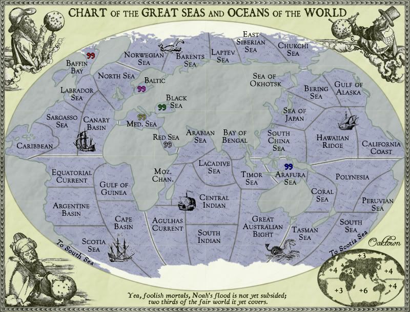
lacadive sea ought to be laccadive sea.
http://www.laccadive.in/
is there such a thing as the philippine sea? south china sea is much better known and the area is very well-defined, bounded by china to the north, the philippines to the east, viet nam and malaysia to the west and malaysia to the south.
http://vm.nthu.edu.tw/southsea/english.index1.htm
timor sea doesn't go north of the equator (that part belongs to south china sea).
it'll be interesting to see how u colour the map!
ian.
-
AndyDufresne

- Posts: 24935
- Joined: Fri Mar 03, 2006 8:22 pm
- Location: A Banana Palm in Zihuatanejo
- Contact:

No big changes... I just wanted to get this started again, now that I've had a bit more time to devote to CC. Calculated bonuses for the regions, and made an inset map that I like better than the old one.
Next on my to do list: play with the overall look of the main map, and make some borders more clear.


jako wrote:edbeard wrote:where on the map do you plan to 'name' the continents?
i dont think he needs to now that he has added the glowing borders to separate the different continents.
I think you have to have names for your continents (and show them to us on the map not just in the XML). Tell them the name of the area they are holding. every map has this.
-
Sir. Ricco

- Posts: 4555
- Joined: Tue Oct 02, 2007 2:33 pm
- Gender: Male
- Location: Making kingdoms burn and bloodshed start.
- Contact:


edbeard wrote:where on the map do you plan to 'name' the continents?
I was wondering how many versions I could produce before somebody called me on this!
The alternative is, of course, no region titles. Other maps haven't done this, but it's not like it would matter much. Over the course of the game as long as you know where the region is and what bonus you stand to pick up by holding it, who gives a damn what it's called really.
The regions will be:
North Atlantic
South Atlantic
Indian Ocean
Arctic Ocean
North Pacific
South Pacific
and I honestly don't know what to call the small region around and including the Med... "The Seas" ?
But honestly, what does the player gain by knowing this?


Unit_2 wrote:How about adding some lakes, like the great lakes and stuff so you can cross the conts.?
Well, if you were a 19th century sailor you couldn't actually cross continents via the great lakes... nor can you do it now.
I have been toying with adding a few rivers to bring the territory count up to closer to 50 - the rivers wouldn't be a part of bonuses, but would make it more challenging to hold a bonus - since each river would border only one ocean/sea territory, they would be like de-facto parts of the regions.
I'd be looking at having the Nile feed into Med, Amazon into Equatorial Current, Mississippi into Caribbean, The Yellow or Yang Tze into S. China Sea, Indus into Arabian Sea, and maybe the Niger into the Gulf of Guinea? That's be 48 terits. ??
RE: the continent labels
I've noticed it for a while but it just felt like the right time to do it.
I just wonder what type of precedent it sets. If it happens then other mapmakers will have an excuse not to do it on their maps. And, no offense to anyone out there, I suspect this will happen quite a bit.
Do you think it would look horrible if there was a 'Middle East' type of labeling?


-
benny profane
- Posts: 248
- Joined: Sat Jun 16, 2007 4:00 pm
- Gender: Male
- Location: Brooklyn, NY
-
Ogrecrusher
- Posts: 250
- Joined: Thu Aug 16, 2007 2:55 pm
FreeMan10 wrote:
Do the two northern seas wrap around the globe to connect on the back side?
(Sorry, don't remember the names, and the pic doesn't show in the topic review.)
if you mean Baffin Bay and Chukchi Sea, i think the ice cap prevents a connection.
Not anymore! The Northwest Passage opened this year I believe ;D
benny profane wrote:FreeMan10 wrote:Do the two northern seas wrap around the globe to connect on the back side?
(Sorry, don't remember the names, and the pic doesn't show in the topic review.)
if you mean Baffin Bay and Chukchi Sea, i think the ice cap prevents a connection.
Right, no 19th century connection. I can make that more clear.
If this were a contemporary map, there'd be almost no ice cap at all - just swimming polar bears.
benny profane wrote:if you mean Baffin Bay and Chukchi Sea, i think the ice cap prevents a connection.
Yup, those are the ones I meant. It doesn't seem that they connect, and there's no "To..." text, like there is at the Antarctic, but I thought I'd ask. May want to make that a bit more clear.
I'm liking the look of this map!

You could add in the Eerie Canal to connect to the Great Lakes.
http://en.wikipedia.org/wiki/Erie_Canal
http://en.wikipedia.org/wiki/Erie_Canal
some little things:
• added region names, with the exception of the seas - not sure what to call it, or where to fit it in. Great Seas? Inner Seas? Or just the Seas?
• color changes.
• added army circles, since it can't hurt given the new colors... already noticed I forgot at least three.
• probably some other things I've forgotten.
-
Incandenza

- Posts: 4949
- Joined: Thu Oct 19, 2006 5:34 pm
- Gender: Male
- Location: Playing Eschaton with a bucket of old tennis balls
Lurves me the graphics on this one, oaktown.
However, the graphics set up a couple of internal contradictions with the map, especially in keeping with the whole "keep it 19th century" concept.
The first problem I have is that there was no Suez Canal back then, and thus no Med-Red connection. Oddly enough, this could work in your favor. Conceptually the three Great Seas (which I think would work fine as a continent name) are all part of the same trading axis, especially given the age of empires that this map suggests. So you could keep Red as part of the continent, but cut off the connection and make the continent non-contiguous (and prolly bump the bonus up one), nicely simulating the whole "shit, we have to sail around half the goddamn world to get these trinkets from genoa to djibouti."
Also the borders are perhaps too crisp for a period map. More to the point, Antarctica is waaaay too crisp. Seems like a perfect point to indulge in some creative license and have either a large "here be dragons" bit (perhaps a bit too old-timey for this map), or an speculative blob labeled Terra Australis (given the fact that the continent was still largely unmapped as late as the mid 20th century).
Sorry, this is me in "pain-in-the-ass historical stickler" mode, which I'm sure you'll remember from berlin.
(of course, if it's an abject choice between gameplay and historical authenticity, I'll always opt for the former, but I think that creative solutions can be found, especially this early in a map's development, that satisfy both)
Speaking of pure gameplay, I don't recall how the previous mapmaker used the 'doldrums' concept, but if we're talking 19th century here, the doldrums could be used as unpassables, given that the doldrums are areas of weak, intermittent winds notorious for impeding the progress of sailors. I noticed that you abandoned the concept early on, but to be honest I think you might have given it short shrift.
THOTA: dingdingdingdingdingdingBOOM
Te Occidere Possunt Sed Te Edere Non Possunt Nefas Est
Te Occidere Possunt Sed Te Edere Non Possunt Nefas Est
-
gimil

- Posts: 8599
- Joined: Sat Mar 03, 2007 12:42 pm
- Gender: Male
- Location: United Kingdom (Scotland)
edbeard wrote:I like pretty much all the changes you've made.
The only thing that I have a problem with is the land itself. For some reason, I feel like the land is sticking out too much. That's the part that jumps out to my eye instead of the ocean.
I dont think this will be a problem once numbers are placed on the map, theres also not much i feel can be done.
What do you know about map making, bitch?
Top Score:2403
natty_dread wrote:I was wrong
Top Score:2403