The mountains look sloppy the patterns arent the great looking the water look mostly like wrinkled blue paper the country backgrounds also do not look that pretty, and most of this map is not appealing to the eye
i'd like to see one or two of the complex issues afflicting the period to appear on the map. as an example, milan was spanish habsburg territory outside the empire. if milan is moved to the spanish habsburg continent, then spanish habsburg can be a non-contiguous continent (like extreme global warming's africa). i have in mind that milan is necessary for the spanish habsburg bonus, but not for the hre bonuses (spanish habsburg excluding milan will qualify for the hre bonuses). do u think this will work?
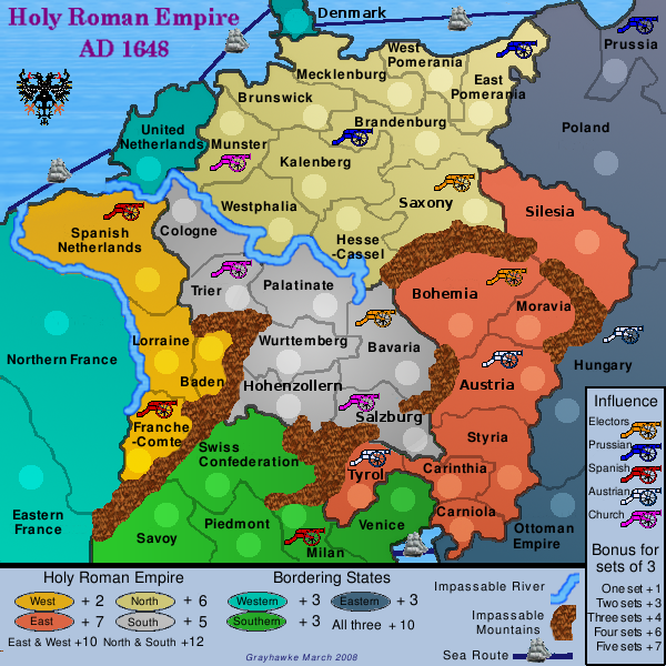
change the title to "holy roman empire AD 1648". AD is supposed to appear before the year (unlike BC). incidentally, it's considered rather old-fashioned to use dots in such abbreviations unless a lack of dots causes confusion. the bit about bordering states in the title is not needed because u clearly state this on the legend as one of the gameplay features.
iancanton wrote:good attempt at a difficult subject!
i'd like to see one or two of the complex issues afflicting the period to appear on the map. as an example, milan was spanish habsburg territory outside the empire. ...
change the title to "holy roman empire AD 1648". ... ian.
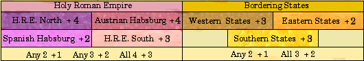
Thx for the suggestions. I admit I may be guilty of over-simplyfying a complex political scenario. I'm now thinking of having a map of 42 territories in 8 continents with extra cross-continent bonus for:
Spanish Habsburg (+Milan) Austrian Habsburg (+Hungary) Bradenburg-Prussia (+Pomerania+Ansbach) Electors (Bohemia-Saxony-Bavaria-Brandenburg)
as well as the existing complete/partial HRE and Border bonuses.
grayhawke wrote:I'm now thinking of having a map of 42 territories in 8 continents with extra cross-continent bonus for:
Spanish Habsburg (+Milan) Austrian Habsburg (+Hungary) Bradenburg-Prussia (+Pomerania+Ansbach) Electors (Bohemia-Saxony-Bavaria-Brandenburg)
as well as the existing complete/partial HRE and Border bonuses.
Or am I now over-complicating?
this concept is excellent. 42 territories (maybe including catholic church lands such as salzburg and cologne) will give a lot more scope to put in gameplay features, like the ones u mention, that are characteristic of the hre. the only way to see if it's too complicated is to try drawing it, then remove features that are difficult to do well.
if u're going to overhaul the map completely instead of doing small changes to v14, then perhaps it's advisable to do each revision on a small 600 x 600 map, then make a large version only after u're in the main foundry. this is to avoid such problems as names or army counts obscuring borders when u downsize from a large map to a small one.
iancanton wrote:...if u're going to overhaul the map completely instead of doing small changes to v14, then perhaps it's advisable to do each revision on a small 600 x 600 map, then make a large version only after u're in the main foundry. this is to avoid such problems as names or army counts obscuring borders when u downsize from a large map to a small one.
ian.
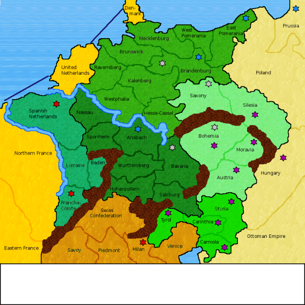
Here's the current state of v15 - obviously still a work in progress, but I thought early feedback would be useful.
Coleman wrote:I missed something, what's going on with the stars you put everywhere?
The stars are related to the political landscape, representing areas of influence of various Powers and confering bonus.
My current thinking is to have 5 sets of 3 stars for Prussian, Church, Austrian, Spanish amd Elector control. Bonus would be awarded for the number of sets held.
This is a complete overhaul of the graphics with more territories (increased from 36 to 42) and with "areas of influence" (from an idea suggested by iancanton)
Last edited by grayhawke on Sat Mar 01, 2008 9:37 pm, edited 1 time in total.
I think this is a really good idea, but in its present state not visually appealing.
-The mountains need a lot of work. They're too dark and don't much resemble mts.
-The colors are way to bright and need to be toned down.
-The stars are kind-of confusing and look too much like a Star of David, (which would be great if the theme dealt with Judaism.) Try to use a different symbol, stars have been used on several maps. Be unique!
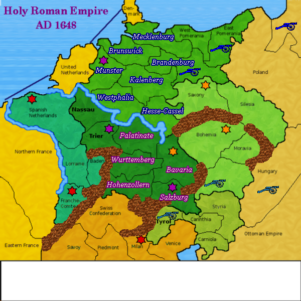
This is the current work-in-progress state of version 16. I am posting this now as I'll be away for the next 10 or so days.
So far I have:
- muted the colours slightly - started changing the names to use a light-coloured font with darker surround - fiddled with the mountains - started to replace the stars with cannons
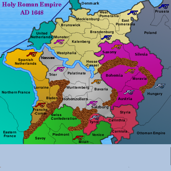
This is the current work-in-progress state of version 17.
The graphics have been revised and I would appreciate peoples' views particularly in comparison with version 16 (see preceeding post).
In version 17 I have:
- changed the colours and removed the overlays - standardized the name font - used cannons for the areas of influence
the cannons look much better than the stars of david. although necessarily much-simplified from the actual situation, the map with cannons and 42 territories appears to be capable of incorporating into the gameplay some recognisable themes of the holy roman empire.
it appears that we have drawn nassau where the electorate of cologne ought to be, between muenster and the spanish netherlands.
iancanton wrote:...it appears that we have drawn nassau where the electorate of cologne ought to be, between muenster and the spanish netherlands. ... it's possible to combine the east and south empire, calling it austria (qualifying for hre bonus), at the same time giving saxony to the north empire. ian.
Version 18 adopts both suggestions, renaming Nassau to Cologne and reducing the divisions to 7.
Two extra sea routes have also been added - Venice-OttomanEmpire and Denmark-Poland