
Bamboo Jack (Thai POW Railway) [Quenched]
Moderator: Cartographers
Forum rules
Please read the Community Guidelines before posting.
Please read the Community Guidelines before posting.
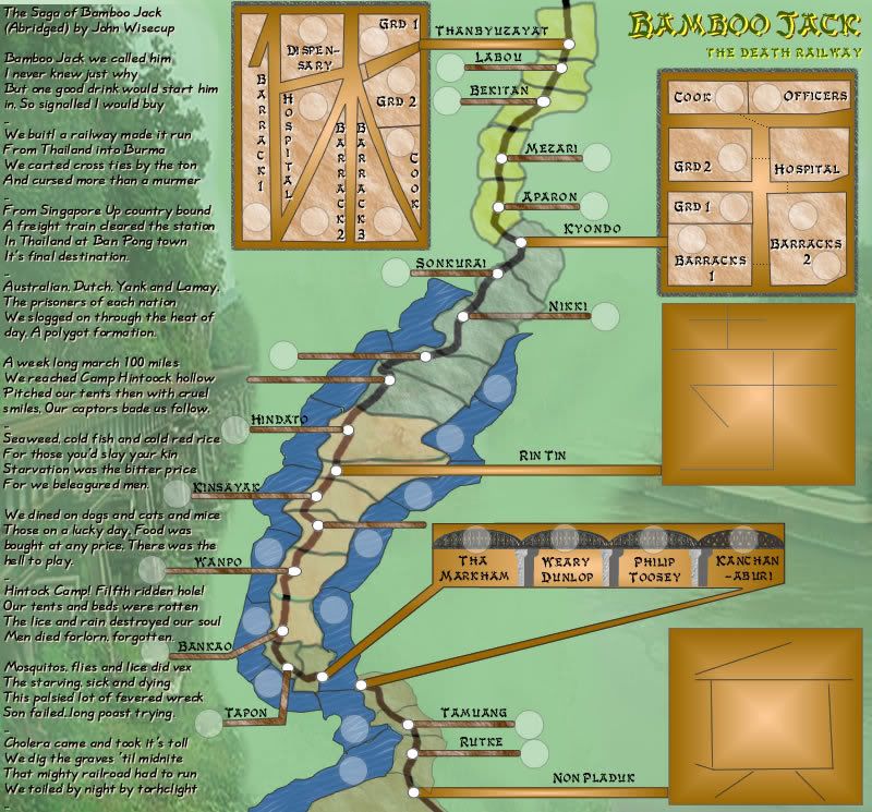
V4 Large and Small
OK Here is the worked version 4.
Legend - only has number of terts in it yet.
Camp maps - created from the Japanese Kanji characters meaning rest, king and soldier in that order from top to bottom
It is very lineal, i'll agree, but i guess that what comes with the railwaym however the rivers each side of most of the line do assist for some diversion.
There will be bonuses for the bridge etc, just javen't worked it wll out yet.
But this is the general idea.
Oh and yes, still a little messy in places design-wise, but those are time issues.
V4 Small

V4 Large
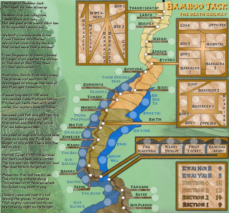
Legend - only has number of terts in it yet.
Camp maps - created from the Japanese Kanji characters meaning rest, king and soldier in that order from top to bottom
It is very lineal, i'll agree, but i guess that what comes with the railwaym however the rivers each side of most of the line do assist for some diversion.
There will be bonuses for the bridge etc, just javen't worked it wll out yet.
But this is the general idea.
Oh and yes, still a little messy in places design-wise, but those are time issues.
V4 Small
V4 Large

* Pearl Harbour * Waterloo * Forbidden City * Jamaica * Pot Mosbi
-
jako

- Posts: 1022
- Joined: Sun Jun 03, 2007 4:50 am
- Gender: Male
- Location: A lost soul with no-one to stalk.
sorry cairns, ive always been a fan of ur maps, but this one just doesnt appeal to me visually or gameplay-wise. the terrs look really weird, and the overall shape of it, and in the middle where its liek the bottleneck effect really disturbs me.
honesty and no offense but this would fall in with my list of maps i wouldnt play.
ps my reasons for y i dislike it are a bit shaky, but i cant quiet explain y.
honesty and no offense but this would fall in with my list of maps i wouldnt play.
ps my reasons for y i dislike it are a bit shaky, but i cant quiet explain y.

Time to retire this much loved sig of mine with a new clan.

I like it so far myself. The problems for me are the routes in the, bleh don't even know what they are called. Boxes that represent something bases? on the map.
Bleh without knowing what they are it's hard to say, the stuff with Cook's and officers and whatever in them don't have very clear routes with the exception of Kyondo.
I also have trouble reading the story. The font you used is too hard on my eyes.
Bleh without knowing what they are it's hard to say, the stuff with Cook's and officers and whatever in them don't have very clear routes with the exception of Kyondo.
I also have trouble reading the story. The font you used is too hard on my eyes.
Warning: You may be reading a really old topic.
jako wrote:sorry cairns, ive always been a fan of ur maps, but this one just doesnt appeal to me visually or gameplay-wise. the terrs look really weird, and the overall shape of it, and in the middle where its liek the bottleneck effect really disturbs me.
would it assist if there were some more LAND terts to ease that bottleneck?
honesty and no offense but this would fall in with my list of maps i wouldnt play.
ps my reasons for y i dislike it are a bit shaky, but i cant quiet explain y.[/quote]
Thanks jako...your honesty is appreciated.
Last edited by cairnswk on Tue Aug 21, 2007 2:13 pm, edited 1 time in total.
* Pearl Harbour * Waterloo * Forbidden City * Jamaica * Pot Mosbi
Coleman wrote:I like it so far myself. The problems for me are the routes in the, bleh don't even know what they are called. Boxes that represent something bases? on the map.
Bleh without knowing what they are it's hard to say, the stuff with Cook's and officers and whatever in them don't have very clear routes with the exception of Kyondo.
I also have trouble reading the story. The font you used is too hard on my eyes.
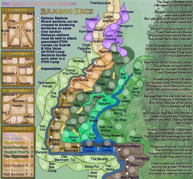
Thanks Coleman...i realise this map is very linear i.e. up and down.
The boxes, apart from the obvious bridge, are the shapes of japanese kanji characters meaning rest, king and soldier.
THE BOXES ARE MEANT TO BE PRISONER OF WAR CAMPS.
This is what this map is about. POW camps and the building of this railway. As you can appreciate it is hard to get all this into one small size map, but i am trying.
I will tidy up the routes into the POW camps, and post this in next version, along with new font for the story.
However, I think this map might get sunk basically the way the votes are going at the top.
* Pearl Harbour * Waterloo * Forbidden City * Jamaica * Pot Mosbi
Okay the POW camps don't have very clear routes inside them is what I was trying to say. Example: I have no clue what Barrack 2 in THANBYUZAYAT can attack.
I have no problems with this map of any kind except for that. IN KYONDO it is done very well as there are dashed lines to help show how the areas interconnect.
I have no problems with this map of any kind except for that. IN KYONDO it is done very well as there are dashed lines to help show how the areas interconnect.
Warning: You may be reading a really old topic.
Coleman wrote:Okay the POW camps don't have very clear routes inside them is what I was trying to say. Example: I have no clue what Barrack 2 in THANBYUZAYAT can attack.
I have no problems with this map of any kind except for that. IN KYONDO it is done very well as there are dashed lines to help show how the areas interconnect.
yes coleman...thanks...i apologise for my taudriness....i will amend this aspect this evening...it's almost time to go to work in an hour.
* Pearl Harbour * Waterloo * Forbidden City * Jamaica * Pot Mosbi
V5 New Design
Well...here we go with V5.
Hopefully this will be more appealing to the audiences.
New design
This is re-designed to include the bridge in the map rather than have it in an outside section like the POW Camps.
Therefore artistic liberty has been taken with the length of the bridge and those closeby sections of the river.
It was very hard to find names of towns etc so I had to fill with some names of Doctors who actually worked in the POW Camps.
Not completed yet
* The Bonuses are not yet calculated.
* I think because of the lineation of the map, there will be a few more terts and impassables to be added to bulk out certain sections, and I may even re-work the railway lines yet to interweave them with other sections on the map, particularly the highlands.
Anyway, it is a start, and hopefully better suited than the last few efforts I created for this map.
Let me know what you think anyway.
V5 Small

V5 Large

Hopefully this will be more appealing to the audiences.
New design
This is re-designed to include the bridge in the map rather than have it in an outside section like the POW Camps.
Therefore artistic liberty has been taken with the length of the bridge and those closeby sections of the river.
It was very hard to find names of towns etc so I had to fill with some names of Doctors who actually worked in the POW Camps.
Not completed yet
* The Bonuses are not yet calculated.
* I think because of the lineation of the map, there will be a few more terts and impassables to be added to bulk out certain sections, and I may even re-work the railway lines yet to interweave them with other sections on the map, particularly the highlands.
Anyway, it is a start, and hopefully better suited than the last few efforts I created for this map.
Let me know what you think anyway.
V5 Small
V5 Large
* Pearl Harbour * Waterloo * Forbidden City * Jamaica * Pot Mosbi
-
gimil

- Posts: 8599
- Joined: Sat Mar 03, 2007 12:42 pm
- Gender: Male
- Location: United Kingdom (Scotland)
how do you get from the terrs down the left hand side to the terrs in the main map.
I only ask this because i do not understand any of the legends.
I do not understand the legends because i have been out drinking.
I apologies in advance cairns if i upset you because of this
I only ask this because i do not understand any of the legends.
I do not understand the legends because i have been out drinking.
I apologies in advance cairns if i upset you because of this
What do you know about map making, bitch?
Top Score:2403
natty_dread wrote:I was wrong
Top Score:2403
gimil wrote:how do you get from the terrs down the left hand side to the terrs in the main map.
I only ask this because i do not understand any of the legends.
I do not understand the legends because i have been out drinking.
I apologies in advance cairns if i upset you because of this
Gimil...I hope you had a very good time.
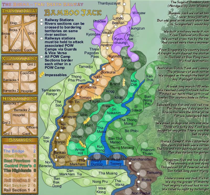
In the "destructions" it says
River sections can be crossed to bordering territories on the same river section
This means that because Rin Tin borders two river sections, you can cross from Thong Pha Phum and Tha Sao to Rin Tin.
Rather than have the river as an impassable, i made it so that it is in sections but provides a border between east and west terrs.
Hope this explains it Gimil.
* Pearl Harbour * Waterloo * Forbidden City * Jamaica * Pot Mosbi
Bamboo Jack V6 Update
OK, so soon after V5 was posted, here is the update for V6.
This version:
* adds terrs to Burma, some to the western province, and some to the eastern province.
* small design issue updates
* Bonuses are still not calculated, but I am working on these today.
With Regard to the Bonuses
The POW camps will be calculated inclusive for the Rail Section they belong to.
V6 Small
V6 Large
* Pearl Harbour * Waterloo * Forbidden City * Jamaica * Pot Mosbi
-
gimil
- Posts: 8599
- Joined: Sat Mar 03, 2007 12:42 pm
- Gender: Male
- Location: United Kingdom (Scotland)
cairnswk wrote:gimil wrote:how do you get from the terrs down the left hand side to the terrs in the main map.
I only ask this because i do not understand any of the legends.
I do not understand the legends because i have been out drinking.
I apologies in advance cairns if i upset you because of this
Gimil...I hope you had a very good time.No apologies needed.
In the "destructions" it saysRiver sections can be crossed to bordering territories on the same river section
This means that because Rin Tin borders two river sections, you can cross from Thong Pha Phum and Tha Sao to Rin Tin.
Rather than have the river as an impassable, i made it so that it is in sections but provides a border between east and west terrs.
Hope this explains it Gimil.
The river wasn't my concern although i do NOW understand that there more to the river than an impassable boarder.
What i meant was how to get from the main map to the (HUTS?) like Kyondo camp.
P.s. i did have a good time. I also found a pub in Glasgow called cairns
I took a pic and then proceeded to break my phone
What do you know about map making, bitch?
Top Score:2403
natty_dread wrote:I was wrong
Top Score:2403
gimil wrote:
The river wasn't my concern although i do NOW understand that there more to the river than an impassable boarder.
What i meant was how to get from the main map to the (HUTS?) like Kyondo camp.
P.s. i did have a good time. I also found a pub in Glasgow called cairns
I took a pic and then proceeded to break my phone
Bugger gimil...i was looking forward to that photo of cairns pub.
About the railway terrs to the POW camps, you will be able to attack Hin Tok Railway to Hin Tok POW Camp Grd 1 or Grd 2 and Vice Versa, and the "destruction" tell you that (at least I think they do)
Railways stations must be held to attack associated POW Camps via Guards & Vice Versa
Do you think it would be necessary to have "graphic routes" between them? I would prefer not to have them, however some further/better wording might be necessary.
* Pearl Harbour * Waterloo * Forbidden City * Jamaica * Pot Mosbi
-
gimil
- Posts: 8599
- Joined: Sat Mar 03, 2007 12:42 pm
- Gender: Male
- Location: United Kingdom (Scotland)
I see where your coming from now.
However i feel that that more recognition is needed. Maybe make each POW camp for distinct and have some kind of relationship between hte station and the camp.
p.s. Ill has the cairns pub pic up ASAP (once the phone is fixed)
However i feel that that more recognition is needed. Maybe make each POW camp for distinct and have some kind of relationship between hte station and the camp.
p.s. Ill has the cairns pub pic up ASAP (once the phone is fixed)
What do you know about map making, bitch?
Top Score:2403
natty_dread wrote:I was wrong
Top Score:2403
gimil wrote:I see where your coming from now.
However i feel that that more recognition is needed. Maybe make each POW camp for distinct and have some kind of relationship between hte station and the camp.
Do mean like a pathway of some sort, or a series of dashed lines to join them?
* Pearl Harbour * Waterloo * Forbidden City * Jamaica * Pot Mosbi
-
gimil
- Posts: 8599
- Joined: Sat Mar 03, 2007 12:42 pm
- Gender: Male
- Location: United Kingdom (Scotland)
cairnswk wrote:gimil wrote:I see where your coming from now.
However i feel that that more recognition is needed. Maybe make each POW camp for distinct and have some kind of relationship between hte station and the camp.
Do mean like a pathway of some sort, or a series of dashed lines to join them?
maybe not a path way but like a symbol or color scheme if your looking to NOT have a direct path between them.
What do you know about map making, bitch?
Top Score:2403
natty_dread wrote:I was wrong
Top Score:2403
Coleman wrote:I think you could do something like a black red or blue dot (colors could be different) for the camps and a corresponding dot in the camps themselves. If that makes any sense.
OK, thanks for the suggestion Coleman...I was just thinking that perhaps also the names be the same colours.
* Pearl Harbour * Waterloo * Forbidden City * Jamaica * Pot Mosbi
-
gimil
- Posts: 8599
- Joined: Sat Mar 03, 2007 12:42 pm
- Gender: Male
- Location: United Kingdom (Scotland)
Coleman wrote:I think you could do something like a black red or blue dot (colors could be different) for the camps and a corresponding dot in the camps themselves. If that makes any sense.
makes no sense at all. Thats either because:
A) alcohol is affecting my sense of interpretation.
B) Colemans drug intact from his broken knee cap is affect his sense of description.
Either or, we make a useless team at this point in time
What do you know about map making, bitch?
Top Score:2403
natty_dread wrote:I was wrong
Top Score:2403
gimil wrote:Coleman wrote:I think you could do something like a black red or blue dot (colors could be different) for the camps and a corresponding dot in the camps themselves. If that makes any sense.
makes no sense at all. Thats either because:
A) alcohol is affecting my sense of interpretation.
B) Colemans drug intact from his broken knee cap is affect his sense of description.
Either or, we make a useless team at this point in time
LOL...well, gimil, i think it does make some sense....perhaps wou need to see it to recognise what it might look like. I'll post a version in a couple of mins.
* Pearl Harbour * Waterloo * Forbidden City * Jamaica * Pot Mosbi