Page 12 of 19
Posted: Mon Dec 03, 2007 6:33 pm
by iancanton
if we are not to consider 33, then i prefer 36 or possibly 37 (maximum of two neutrals) or 40 (maximum of one neutral unless 6 are playing).
if 40, then the obvious one is named territories for the four cities that are completely separate from the counties in which they are currently situated. this works for three of the cities, but not for edinburgh, which will look messy when squashed into the northern part of midlothian.
if 40, then my alternative is (assuming separate cities don't work well visually):
• split uist into north and south (for 36 and 37 as well as 40) and re-draw it as two islands, then move mull from the western isles to strathclyde;
• split lanarkshire into north and south (gimil's suggestion);
• add dunbartonshire (or is it dumbartonshire - gimil, being the west-coaster, can u tell us?), made much bigger than "real" size by cannibalising a bit of argyll;
• add bute (the island to the left of renfrew) or, if too small, then east ayrshire.
ian.

Posted: Mon Dec 03, 2007 8:45 pm
by oaktown
iancanton wrote:if we are not to consider 33, then i prefer 36 or possibly 37 (maximum of two neutrals) or 40 (maximum of one neutral unless 6 are playing).
we can certainly consider 33 - everything is still on the table unless Balsie doesn't go for it. 37 or 38 don't solve the first turn advantage problem.
Posted: Mon Dec 03, 2007 8:52 pm
by iancanton
yes, now that u mention it, i see why 37 isn't an improvement on 36.
ian.
Re: SCOTLAND map(OV2.4graphic:pg1/17)(GV1.9gameplay:pg1/17)N
Posted: Mon Dec 03, 2007 9:17 pm
by rgbubba
Balsiefen wrote:CURRENT MAPScotlandOaktown V2.4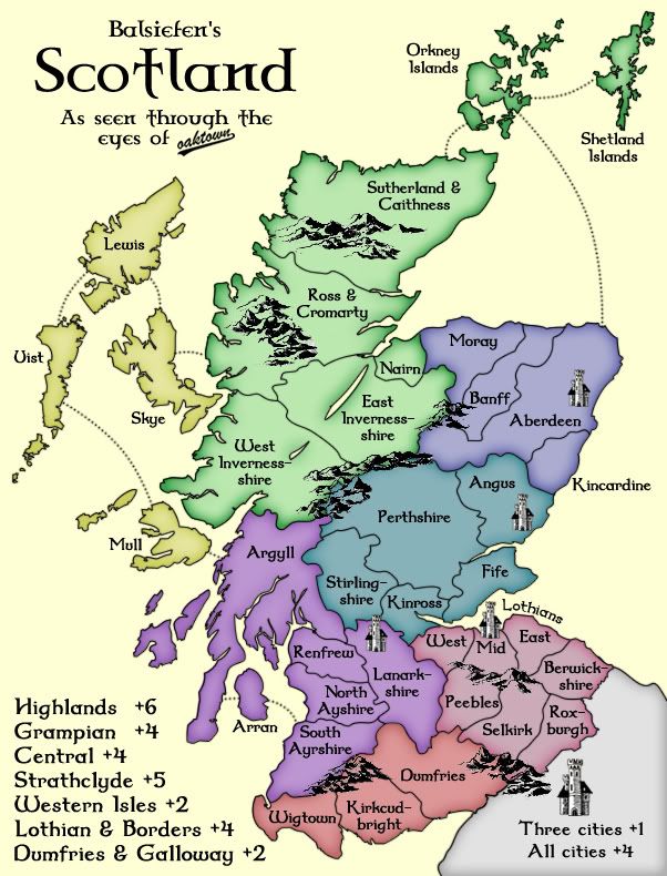
I like the layout of this map. I have friends that live there. Thinking about using boats for exrta points. Keep it up.
_____________________________________________________________
HOWDY!!!
Posted: Mon Dec 03, 2007 10:25 pm
by Blitzaholic
oaktown wrote:small map, 457x600:

Large map, 602x790:
So, I've changed up the colors a bit... as a colorblind user I find this color scheme to be more friendly.
Also, first stab at small map. It'll take some work fitting in army counts, but it's doable.
iancanton wrote:here's another idea: rather than adding three territories, how does deleting three compare (i think the natural mergers are reuniting ayrshire, reuniting inverness-shire and combining argyll with mull, as mull was always part of argyll and not part of the western isles)?
You would only have to delete one territory to avoid the first turn advantage, but fewer than 36 territory makes for thin starts in larger games. It's worthy of further discussion.
looks well crafted, nice job oaktown
now can you do a las vegas casino map for me

Posted: Tue Dec 04, 2007 6:28 am
by Balsiefen
Sorry i havn't looked for a bit but i've been having an awful few days.
Anyway, i'm afraid i'm a litytle out of touch. How do certain amounts of territories delete first turn advantage? Personally, i'm with oaktown for size. I would prefer a medium sized map to a small one.
Anyway, glad to see people have taken an inerest and i'll try to make more useful desisions once i have more time and have got my bearings
Posted: Tue Dec 04, 2007 10:38 am
by gimil
Balsiefen wrote:Sorry i havn't looked for a bit but i've been having an awful few days.
Anyway, i'm afraid i'm a litytle out of touch. How do certain amounts of territories delete first turn advantage? Personally, i'm with oaktown for size. I would prefer a medium sized map to a small one.
Anyway, glad to see people have taken an inerest and i'll try to make more useful desisions once i have more time and have got my bearings
well with 36 terrs in a three player game and 1v1 games each palyer starts with 12 terrs. this means a deploy of 4. However if you go 1st you can simply take 1 of your enemeys terrs to reduce there deploy to 3 rather than 4.
Posted: Tue Dec 04, 2007 8:28 pm
by oaktown
Right: there was a recent discussion about what is really the best method for coming up with a starting territory count: minimizing neutrals, or minimizing a first turn advantage. By making a 36 territory map we are making for lousy game play in two and three player games, where the player who goes first gets an automatic advantage over an opponent if he's able to take just one territory on that first turn. Plus the closer we get the the classic 42 the more street cred the map has!
Thanks to Ian and Gimil for the following suggestions:
1. split uist into north and south and re-draw it as two islands, then move mull from the western isles to strathclyde;
2. split lanarkshire into north and south;
3. add dunbartonshire, made much bigger than "real" size by cannibalising a bit of argyll;
4. add bute (the island to the left of renfrew) or,
5. add East Ayrshire.
Graphically I can do #1, #2 and #5 pretty easily. I actually tried fitting it Dumbartonshire when I moved Stirling to Central, but it was really messy because there's so much going on right there. Bute would have the same issue.
I'd like to add some suggestions which are from a gameplay and graphics point of view only:
6. Split Sutherland and Caithness up again, as per Balsie's original (which I talked him into changing... sorry!). Plenty of space up there, and with the new Aberdeen attack route it would make for an interesting circular attack path.
7. Split the Dumfries territory in half. I'm not sure this makes any sense geo-politically, but it would make the region a four territory +4 with two borders, bringing it in line with the Western Isles.
8. Further split up Perthshire. It would be nice to have a second territory in that region that isn't a border territory because right now it's a bitch to hold.
9. Leave the other three cities alone, but make Aberdeen it's own territory. Politically it seems to have been a different council area than Aberdeenshire anyway, and putting another territory in that region would make it warrant the higher bonus (which I see is in error on my map - should be +3 I think).
In other news, would anybody be opposed to calling Stirlingshire simply Stirling? It seems to be the name of the larger council area that includes Stirlingshire and part of Perthshire, and would eliminate one hyphen.
Posted: Tue Dec 04, 2007 10:36 pm
by iancanton
6. provides more visual balance, though highlands will be even harder to hold and we already have the circular route through orkney;
7. splitting dumfries doesn't make much sense to me, unless three-territory continents are considered to be undesirable;
8. this is a good idea that balsie has also mentioned and there is a way to do it in accordance with historic county boundaries -
8.1 expand stirling eastward (i think no-one will object to dropping the shire here) to cut off kinross from west lothian, giving central only three border territories;
8.2 expand kinross northward and rename it clackmannan;
8.3 carve out south-east perthshire and call it kinross, bordering perthshire, fife and clackmannan (it doesn't matter if the border isn't accurate, as long as kinross borders these three territories and clackmannan borders four);
9. aberdeen, like the other three cities, had its own council that was separate from its county, so isn't a special case, but i prefer it over adding caithness because it helps to solve the bonus army question.
oaktown, i'm another one who'd like to add my appreciation for ur superb contribution to the graphics on this map.
ian.
Posted: Tue Dec 04, 2007 11:53 pm
by oaktown
Thanks ian. I'm going to wait on Bals to weigh in on how he'd like to change this up, or if he thinks it is fine as is.
I think I can fit in three more territories pretty easily... four may be possible, but getting us up to the "classic" 42 would be a stretch.
Posted: Wed Dec 05, 2007 11:29 am
by Balsiefen
Ideally i would like to up the territory count to 38 or 40
As for playability:
Split sutherland/caithness-Actually, i'm quite for this, it will give the highlands more reason to be a 6 with 4 boarders
split uist-could be good but it leads to having a 2 bonus for 5 terrs while dumfries has 2 bonus for 3 terr so we would have to change that somehow (islands boosted to 3 bonus?)
Split lanark- again, a good idea. it will make strathclyde harder to hold but that can be compencated for.
Adding aberdeen-Actually, i like that as well. it wouldnt make grampian that much harder to hold and it is correct. problem is, what would we call the two new terrs
As for clackmanann, i would like to see it as a sort of test but i cant visualise it all when i'm thinking about bonus' as well.
Anyway, Oaktown could you produce a test map with caithness and sutherland split, aberdeen split, the kinross/clackmannan idea and splitting uist. that way we can add 4 territories and drop a couple if needs be.
As for bonuses, with those changes, Islands goes up to 3
Posted: Wed Dec 05, 2007 5:47 pm
by iancanton
Balsiefen wrote:split uist-could be good but it leads to having a 2 bonus for 5 terrs while dumfries has 2 bonus for 3 terr so we would have to change that somehow (islands boosted to 3 bonus?)
we can reduce western isles to 4 territories again by moving mull to strathclyde. mull was never part of the western isles, but was (and is) administered from argyll, so strathclyde is its natural home.
irrespective of whether we split uist as a territory, it will be good to have uist drawn as two islands rather than one.
i recall someone (i had a look - it was neoni) asking for the big island in the western isles to be called "lewis and harris". i suppose neoni must come from the harris part of this island!
ian.
Posted: Thu Dec 06, 2007 1:20 am
by oaktown

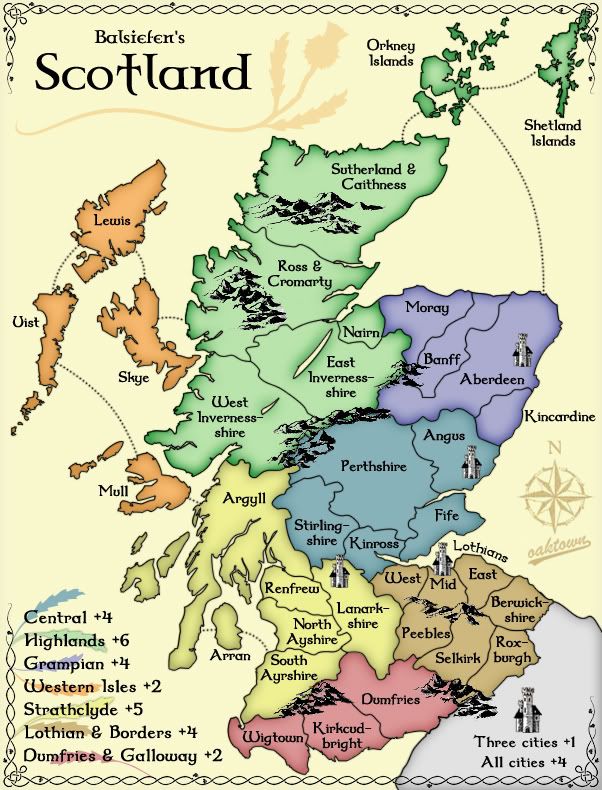
Alright, we're up to 41 territories. Added Clackmanshire, East Ayshire, City of Aberdeen, Caithness, and split Uist.
42 would be ideal, but things are already looking pretty cramped - and this is the large map. I'd think I'd rather drop one of the smaller territories to put us at a nice even 40 than add a 42nd.
I also took the liberty to recalculate the bonuses.
Posted: Thu Dec 06, 2007 3:01 am
by Balsiefen
I agree. Looking at it, i think clack looks about the most cramped, especially as the name doesn't fit. I think we could lose it quite happily from a gameplay point of view but from the maps i've seen, i've never seen kinross there. Does anyone know if it is still correct?
Posted: Thu Dec 06, 2007 9:17 am
by oaktown
Balsiefen wrote:I agree. Looking at it, i think clack looks about the most cramped, especially as the name doesn't fit. I think we could lose it quite happily from a gameplay point of view but from the maps i've seen, i've never seen kinross there. Does anyone know if it is still correct?
Every map of Scotland is different. Really, you all should try to keep your surveying teams out of the pubs during their lunch breaks, because it's got to be hell on local administration efforts.

Here's a map showing Kinross as Ian suggested it should be... in fact this map is shockingly close to what we have right now.

And Google has Kinross in about the same place:
But I agree that it makes Central quite muddled. Clackmanshire seems to me to be the most obvious drop, leaving us with a nice round 40.
Posted: Thu Dec 06, 2007 10:57 am
by Balsiefen
Thats convenient. I've found the map i had been using to be innacurate in many other places. I still think our best bet is to drop clack for now as thats the most cramped. I'll have a look to see if one of the uists is called somthing else as well
Edit: Looks as if north and south uist is correct:

Does anyone think we should take strahclyde up to 7 or keep it at 6? For referance, classic map asia has 12 terrs with 4 boarders, Strathclyde has only 8 terrs but 5 boarders and is in a bottleneck between north and south
Posted: Thu Dec 06, 2007 1:14 pm
by iancanton
oaktown wrote:Clackmanshire seems to me to be the most obvious drop, leaving us with a nice round 40.
Balsiefen wrote:I still think our best bet is to drop clack for now as thats the most cramped.
we have consensus. after it absorbs clackmannan, kinross will have enough room for its name!
Balsiefen wrote:Does anyone think we should take strahclyde up to 7 or keep it at 6? For referance, classic map asia has 12 terrs with 4 boarders, Strathclyde has only 8 terrs but 5 boarders and is in a bottleneck between north and south
agreed, since lanarkshire's pivotal location means that it'll be the victim of more than its fair share of attacks. same with argyll.
oaktown wrote:finalize bonuses... are we upping the cities to +5?
this looks necessary to keep the cities relevant. now that the city of aberdeen is no longer adjacent to angus, a player needs to conquer four extra territories to gain the cities bonus if he doesn't want his forces to be isolated.
finally, swap the names of east ayrshire and south ayrshire with each other!
ian.
Posted: Thu Dec 06, 2007 2:08 pm
by Balsiefen
iancanton wrote:oaktown wrote:finalize bonuses... are we upping the cities to +5?
this looks necessary to keep the cities relevant. now that the city of aberdeen is no longer adjacent to angus, a player needs to conquer four extra territories to gain the cities bonus if he doesn't want his forces to be isolated.
finally, swap the names of east ayrshire and south ayrshire with each other!
ian.
Good, i agree, cities up to 5 please.
And of course, i was wondering why east ayrshire was looking strange. I should have caught on sooner seeing that half my family comes from there
Looks like gameplay is sorting itself out

Posted: Thu Dec 06, 2007 8:54 pm
by oaktown
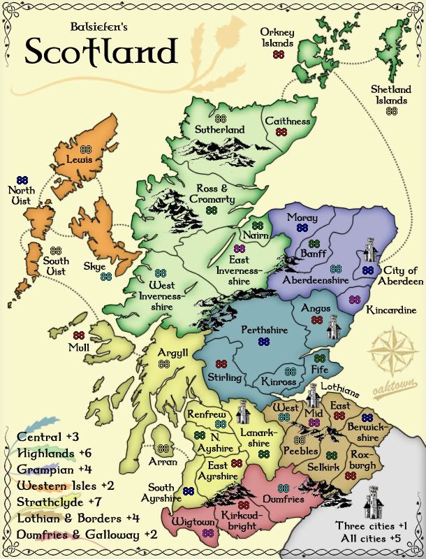
Clack is gone, and we now have a nice and tidy 40 territory map. I'm not saying it's done in terms of territory arrangement, but this is definitely the most playable set-up we've had so far.
Bonuses: I've increased the Cities and Strath bonuses as suggested, and I also took the liberty of dropping Central to +3... with only three borders and five territories it is now smaller than Africa in the Classic map, so in my opinion not worthy of a +4.
Army counts: they aren't in perfect spots or anything, and the XML doesn't exist yet, but does anybody feel that army shadows are necessary? Personally I feel that the numbers are very readable against the soft colors of this map, and I have every intention of keeping them away from borders, mountains and text so there shouldn't be any clutter.
iancanton wrote:finally, swap the names of east ayrshire and south ayrshire with each other!
Some kind of cartographer I am - don't know my east from south!
Posted: Thu Dec 06, 2007 10:55 pm
by edbeard
could you maybe switch the orange with one of the blues just to avoid any confusion?
I know there's a few clues since the name of one of the continents is central, but unless there's a good reason for the two blues (I know that one is more purple and the other more grey/teal) to be right next to each other, idiot proofing the map is almost never a bad idea.
Posted: Thu Dec 06, 2007 11:23 pm
by oaktown
edbeard wrote:could you maybe switch the orange with one of the blues just to avoid any confusion?
I know there's a few clues since the name of one of the continents is central, but unless there's a good reason for the two blues (I know that one is more purple and the other more grey/teal) to be right next to each other, idiot proofing the map is almost never a bad idea.
Funny, I spent so much time trying to figure out how to keep the orange and tan apart I missed the blues... and to my whacked eyes they are very different, but I know I don't quite see right.

What if the purple-blue was a bit more purple?
Posted: Thu Dec 06, 2007 11:24 pm
by edbeard
that would probably work. My problem is on the legend mostly. The blues aren't as distinguishable to me there.
Posted: Fri Dec 07, 2007 12:10 am
by oaktown
edbeard wrote:that would probably work. My problem is on the legend mostly. The blues aren't as distinguishable to me there.
Right - the beauty of making the Western Isles one of the blues is that it would be hard to think that any other region was Western Isles.
Posted: Fri Dec 07, 2007 6:43 am
by iancanton
oaktown wrote:I also took the liberty of dropping Central to +3... with only three borders and five territories it is now smaller than Africa in the Classic map, so in my opinion not worthy of a +4.
that's a strong argument!
this 1892 (!) map from the national library of scotland website shows the kincardine-aberdeen border following the river dee exactly. the city of aberdeen is located on the north bank of river dee where it meets the sea. shall we make kincardine adjacent to the city of aberdeen, as implied by the 1892 map, if only to make the shape of aberdeenshire look less contrived?
http://www.nls.uk/maps/early/scotland.cfm?id=780
there's a missing r in north ayrshire.
the sea routes look ace compared with numerous attempts on other maps that i've seen.
ian.
Posted: Fri Dec 07, 2007 7:49 am
by Balsiefen
iancanton wrote:oaktown wrote:I also took the liberty of dropping Central to +3... with only three borders and five territories it is now smaller than Africa in the Classic map, so in my opinion not worthy of a +4.
that's a strong argument!
this 1892 (!) map from the national library of scotland website shows the kincardine-aberdeen border following the river dee exactly. the city of aberdeen is located on the north bank of river dee where it meets the sea. shall we make kincardine adjacent to the city of aberdeen, as implied by the 1892 map, if only to make the shape of aberdeenshire look less contrived?
http://www.nls.uk/maps/early/scotland.cfm?id=780there's a missing r in north ayrshire.
the sea routes look ace compared with numerous attempts on other maps that i've seen.
ian.
Okay, good. I agree with oaktowns bonus change and, looking at the map, moving aberdeen down looks correct also. And the r in ayr