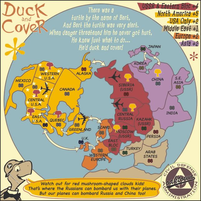
I think because the continental color choice allowed Oaktown not to need army shadows.
--Andy
Duck & Cover [Quenched]
Moderator: Cartographers
Forum rules
Please read the Community Guidelines before posting.
Please read the Community Guidelines before posting.
-
AndyDufresne

- Posts: 24935
- Joined: Fri Mar 03, 2006 8:22 pm
- Location: A Banana Palm in Zihuatanejo
- Contact:
-
Herakilla

- Posts: 4283
- Joined: Fri Jun 09, 2006 8:33 pm
- Location: Wandering the world, spreading Conquerism
oaktown wrote::) Nice. I'm bracing myself for the flood of activity that Forge status may bring, if Puget and Civil War are any indication of how busy the Forge is these days.
By the way, the Final Forge announcement could stand some updating... "revived" suggests the map thread was dead, "discussion" can't make a conclusion but the participants in the discussion can, and I'm not sure what the hell "exmined" means but I bet it hurts.
it also needs a picture. final forge could have like a sword in the final stages of being forged
and quench needs a stamp to make it notarized lol
but now back to your map. i like it! a bit small for my tastes but that never stopped me from playing doodle. also i really dont think you had to bother with triple digits lol, this is another doodle basically and i doubt armies will reach 100 or more unless there is an agreed upon build game
Come join us in Live Chat!
-
Incandenza

- Posts: 4949
- Joined: Thu Oct 19, 2006 5:34 pm
- Gender: Male
- Location: Playing Eschaton with a bucket of old tennis balls
Congrats on the ff, oaktown. Somehow I doubt that you'll have the same problems as Tisha and Elijah. They made geographical maps that some consider to be graphically deficient. Your map is cartoony on purpose and graphically damn tight.
Though I must confess that I might never play it, since I'm down about 100 points on your maps (0-2 on berlin, 1-4 in checkers).
Though I must confess that I might never play it, since I'm down about 100 points on your maps (0-2 on berlin, 1-4 in checkers).
THOTA: dingdingdingdingdingdingBOOM
Te Occidere Possunt Sed Te Edere Non Possunt Nefas Est
Te Occidere Possunt Sed Te Edere Non Possunt Nefas Est


Oakey - vicious XML structure - not heard of white space or comments!!!
(Not that it really matters - it looks good to me!!)
Except...
C.
(Not that it really matters - it looks good to me!!)
Except...
Code: Select all
<name>Midle East</name> C.

Highest score : 2297

yeti_c wrote:Oakey - vicious XML structure - not heard of white space or comments!!!
(Not that it really matters - it looks good to me!!)
Except...Code: Select all
<name>Midle East</name>
C.
Wow, good catch... territory name typos will get caught by the XML checker as inconsistencies, but continent name typos just float on through!
As for XML structure, other than my initial experience of imitating the code of other maps and later figuring out how the XML updates work, I really don't know the first thing about writing code. I could probably still put together a Lynx-compatible web site if I was pressed, but I don't suppose anybody is playing CC on a VT100 terminal. Anyway, the Midkemia map's XML was held up because gnome did something illegal in his comments, and we never figured out exactly what it was - we ended up deleted all of the comments and it worked fine. The experience left me a bit weary of anything that doesn't absolutely have to be there.

oaktown wrote:yeti_c wrote:Oakey - vicious XML structure - not heard of white space or comments!!!
(Not that it really matters - it looks good to me!!)
Except...Code: Select all
<name>Midle East</name>
C.
Wow, good catch... territory name typos will get caught by the XML checker as inconsistencies, but continent name typos just float on through!
As for XML structure, other than my initial experience of imitating the code of other maps and later figuring out how the XML updates work, I really don't know the first thing about writing code. I could probably still put together a Lynx-compatible web site if I was pressed, but I don't suppose anybody is playing CC on a VT100 terminal. Anyway, the Midkemia map's XML was held up because gnome did something illegal in his comments, and we never figured out exactly what it was - we ended up deleted all of the comments and it worked fine. The experience left me a bit weary of anything that doesn't absolutely have to be there.
Fair enough...
FFR - comments look like this...
Code: Select all
<!-- COMMENT -->or
Code: Select all
<!-- Comment
Over
More
than
one line-->
C.
Highest score : 2297

Chirondom wrote:Great map. One minor graphical thing, though-the stars look like snow-flakes. Maybe you ought to just put the US flag stars on it?
 Dude, where were you 12 pages ago when I had proper stars and everybody told me to change them? In retrospect, I liked them better than the asterisks.
Old image alert!


-
The Weird One

- Posts: 7059
- Joined: Fri May 11, 2007 8:21 pm
- Location: cursing the spiteful dice gods
Unit_2 wrote:Good job Oak, sorry for nit-picking
, but is there anyway you can put the army numbers below these territorys: Every USA territory, Greenland, Every Russian territory(but Kazahk and Siberia) , Western Europe , India and Persia .
If not please explain why.
...i mean under the names, not on top or beside.
P.S. I also see that Japan, the UK and Turkey have the army numbers beside the names. I also see there is still a green line around the Black Sea, a little into the Medditerainien , the top of Turkey, around the Red sea and the top borders of Persia.
While it would be great to have everything uniform, they are where they fit. I don't think there's a map on this site that has every count int he same exact place relative to the territory title... hell, in Classic some of the counts are actually sitting on the titles themselves. Japan and Korea are funny shapes so there's no way I can put the title and army count in the territory, let alone put the count below it. So unless there is any objection I would like to classify this as an unusual and unreasonable request.
As for the 'green lines,' I'll recheck all of the territories this weekend to make sure the borders and the background colors mesh.
-
Night Strike

- Posts: 8512
- Joined: Wed Apr 18, 2007 2:52 pm
- Gender: Male

-
unriggable

- Posts: 8037
- Joined: Thu Feb 08, 2007 9:49 pm

oaktown wrote:Unit_2 wrote:Good job Oak
If not please explain why.
...i mean under the names, not on top or beside.
P.S. I also see that Japan, the UK and Turkey have the army numbers beside the names. I also see there is still a green line around the Black Sea, a little into the Medditerainien , the top of Turkey, around the Red sea and the top borders of Persia.
While it would be great to have everything uniform, they are where they fit. I don't think there's a map on this site that has every count int he same exact place relative to the territory title... hell, in Classic some of the counts are actually sitting on the titles themselves. Japan and Korea are funny shapes so there's no way I can put the title and army count in the territory, let alone put the count below it. So unless there is any objection I would like to classify this as an unusual and unreasonable request.
As for the 'green lines,' I'll recheck all of the territories this weekend to make sure the borders and the background colors mesh.
I concur on the numbers - they're fine where they are.
C>
Highest score : 2297

oaktown wrote:unriggable wrote:I know I'm being a hardass but in the poem replace 'threaten' with 'came by' or another two syllable synonym that goes like that since right now it sounds jagged and retardedly fucked up.
You're looking at an old version of the map.
Hey, maybe an ice cap or something in the middle?

The Pro-Tip®, SkyDaddy® and
 are registered trademarks of Backglass Heavy Industries.
Unit_2 wrote:I also see there is still a green line around the Black Sea, a little into the Medditerainien , the top of Turkey, around the Red sea and the top borders of Persia.
I've never hid the fact that I am CC's premier color blind mapmaker
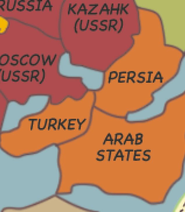
oaktown wrote:Unit_2 wrote:I also see there is still a green line around the Black Sea, a little into the Medditerainien , the top of Turkey, around the Red sea and the top borders of Persia.
I've never hid the fact that I am CC's premier color blind mapmakerso I need a bit of help... is everybody else seeing these green lines? Because all I'm seeing is the occasional blend from the border color to the regional background color.
Green?
The only green line I see is in the lower right hand corner between the ocean and the white w/black spots area.
The Pro-Tip®, SkyDaddy® and
are registered trademarks of Backglass Heavy Industries.I think it's an optical illusion with the convergence of the 3 colours there... the red on one side - the blue on the other... and the "black" line in the middle - if you're eyesight's a bit off - then I suspect it will bleed the colours into one another and turn the black green...
C.
C.
Highest score : 2297
