Page 2 of 21
Posted: Wed Oct 03, 2007 7:22 pm
by Unit_2
a update is here!!!!
bnow, there are two things that i need you to know. yes there is small dots around the island but if i make the background white its too hard to on your eyes.
 http://i20.tinypic.com/2ibiyjq.jpg
EDIT: there are 41 territorys and 7 conts.
Posted: Thu Oct 04, 2007 12:22 am
by oaktown
I suggest you decide if this is going to be a vertical or horizontal map - going 45° may not be the best use of space. Like the Italy map, you don't have to make your map align perfectly north-south.
Posted: Thu Oct 04, 2007 5:12 pm
by Unit_2
that is the only way it fits

Posted: Thu Oct 04, 2007 8:15 pm
by unriggable
Unit_2 wrote:that is the only way it fits
That's what she said. Make it smaller.
Posted: Thu Oct 04, 2007 8:54 pm
by t.e.c
and you're missing hokkaido from the top
Posted: Thu Oct 04, 2007 10:40 pm
by gimil
for the size restrictions you need to take at the very least 5px off the height. But if you can manged id bring it down to 600x600. Also unit please included terr names and a working legends before ill be able to give proper feedback on this one
Posted: Thu Oct 04, 2007 11:19 pm
by oaktown
Unit_2 wrote:that is the only way it fits
Hmm... let's see...
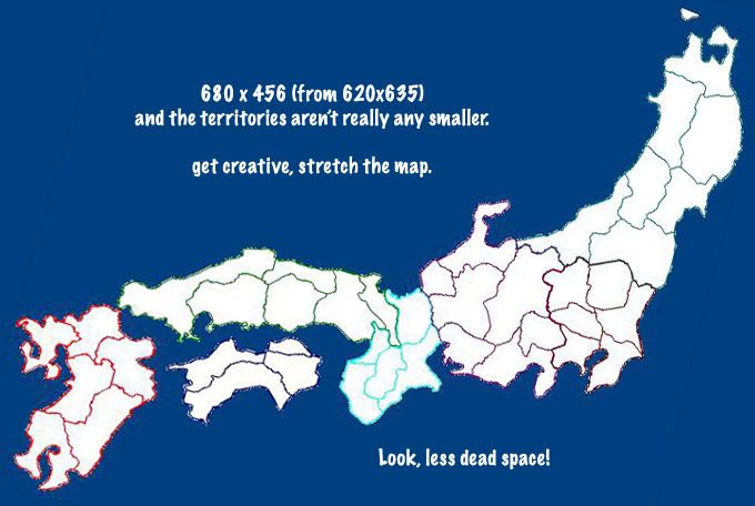
I'm not saying this is better, I'm just saying you can play with it. Move north, stretch it out a touch, etc.
Posted: Thu Oct 04, 2007 11:34 pm
by Unit_2
gilmil i will get that good so you can fix it for me.
Posted: Thu Oct 04, 2007 11:37 pm
by gimil
oaktown wrote:Unit_2 wrote:that is the only way it fits
Hmm... let's see...
I'm not saying this is better, I'm just saying you can play with it. Move north, stretch it out a touch, etc.
good attemp oaktown but it would seem that your 80px or the restriction

Posted: Thu Oct 04, 2007 11:37 pm
by t.e.c
but you're still missing hokkaido

Posted: Thu Oct 04, 2007 11:54 pm
by Som General
reminds me of italy map wich has already become one of my faverites.
I think you should add some islands like you mentioned and maybey if you still had hella extra space you could add south korea
like the japan risk map in warcraft 3 if anyone knows what I'm takin about
Posted: Thu Oct 04, 2007 11:59 pm
by oaktown
gimil wrote:good attemp oaktown but it would seem that your 80px or the restriction
Actually, I'm 120 pix UNDER the limit. The max for the large map is 600 H x 800 W... there would obviously have to be a smaller version.
And yes, still missing hokaido... I was only suggesting a possible orientation of Unit's latest map, not presenting a map for discussion.
Posted: Fri Oct 05, 2007 12:24 am
by gimil
KEYOGI wrote:Any map in development must stick to the following map size criteria:
* You must design two versions of the map:
o A small (up to 600px wide), and
o A large (up to 800px wide).
* Height is flexible, but it is recommended that you do not exceed:
o 350px on small maps, and
o 600px on large maps.
* Height must not be any greater than:
o 600px on small maps, and
o 800px on large maps.
Now, Andy and myself have been and will continue to be a little lenient with width. A map should be designed to fit the width of 600px for the small map, and 800px for the large map. However, if the space is really needed we will allow a small map width of 630px, and a large map width of 840px. This really is only to be used for a desperate scenario though, so please don't abuse our kindness and generosity. Very Happy
I was under the impression this was a small image. which basically means a maximum of 600x600
if this is a large version its gonig to be pushing for space on a small map.
Posted: Fri Oct 05, 2007 5:53 pm
by Unit_2
here is a update, hows it look?

Posted: Fri Oct 05, 2007 10:09 pm
by t.e.c
you could move the legend to the bottom and put hokkaido in the top right corner.
also there are some problems with the prefectures:
- aomora should be aomori
- niigate should be niigata
- toyama should be chiba
- most of chiba should be kanagawa (tokyo's a small sliver between saitama and kanagawa)
- tokyo should be shizuoka
- kanagawa should be yamanashi
- yamanashi should be gifu
- osake should be osaka
- saga could be split in two, with the right side being saga, the left being nagasaki
i think that's all, but i could have made a mistake good luck!

Posted: Fri Oct 05, 2007 10:25 pm
by Unit_2
t.e.c wrote:you could move the legend to the bottom and put hokkaido in the top right corner.
also there are some problems with the prefectures:
- aomora should be aomori
- niigate should be niigata
- toyama should be chiba
- most of chiba should be kanagawa (tokyo's a small sliver between saitama and kanagawa)
- tokyo should be shizuoka
- kanagawa should be yamanashi
- yamanashi should be gifu
- osake should be osaka
- saga could be split in two, with the right side being saga, the left being nagasaki
i think that's all, but i could have made a mistake good luck!
thanks... very reassurring...

lol
i'll try to change it
Posted: Fri Oct 05, 2007 10:33 pm
by t.e.c
it's best to be accurate early on, because someone down the line is going to complain.

Posted: Sat Oct 06, 2007 10:09 pm
by Unit_2
ok, here it is(is this good tec?)

Updates:
-Fixed the names
Posted: Sat Oct 06, 2007 10:24 pm
by gimil
Unit i think you might be onto something here for a change.
P.s. im not sizing it for you
thats an easy think to do yourself.
Edit: If you get this far enought ill work on the XML. I need to brush up on my coding skills after the portugal disastar:P
Posted: Sat Oct 06, 2007 10:28 pm
by muy_thaiguy
I like it, but please fill in the colors in the territories.

Posted: Sat Oct 06, 2007 10:29 pm
by gimil
muy_thaiguy wrote:I like it, but please fill in the colors in the territories.
i think units jsut trying to sort gameplay before the graphics part starts
Posted: Sun Oct 07, 2007 3:24 am
by t.e.c
Unit_2 wrote:ok, here it is(is this good tec?)
Updates:
-Fixed the names
yep that's good, except i made a mistake: ibaragi should be ibaraki. and you should really put tokyo in somehow, it's kind of important. you could cut kanagawa in half and put tokyo in there.
Posted: Sun Oct 07, 2007 12:40 pm
by AndyDufresne
Long long ago, when the original japan map was being worked on, there was a problem with bottlenecking due to the size and shape of Japan. Haydena added some ports to help alleviate this problem, and increase flow around the map. It's something to consider.
--Andy
Posted: Sun Oct 07, 2007 12:44 pm
by Unit_2
AndyDufresne wrote:Long long ago, when the original japan map was being worked on, there was a problem with bottlenecking due to the size and shape of Japan. Haydena added some ports to help alleviate this problem, and increase flow around the map. It's something to consider.
--Andy
what exactly are you saying?
Posted: Sun Oct 07, 2007 8:32 pm
by d.gishman
Basically, allow territories that are not physically adjacent to each other to be able to attack and fortify between each other.