[phpBB Debug] PHP Warning: in file [ROOT]/viewtopic.php on line 1091: Undefined array key 0
[phpBB Debug] PHP Warning: in file [ROOT]/viewtopic.php on line 1091: Trying to access array offset on null
[phpBB Debug] PHP Warning: in file [ROOT]/viewtopic.php on line 1098: Undefined array key 0
[phpBB Debug] PHP Warning: in file [ROOT]/viewtopic.php on line 1098: Trying to access array offset on null
[phpBB Debug] PHP Warning: in file [ROOT]/viewtopic.php on line 1098: Undefined array key 0
[phpBB Debug] PHP Warning: in file [ROOT]/viewtopic.php on line 1098: Trying to access array offset on null
Conquer Club • [Abandoned] - WW1 Empires Map - Page 2
Page 2 of 3

Posted: Sun Jan 21, 2007 2:53 pm
by Guiscard
Image

Posted: Sun Jan 21, 2007 3:07 pm
by Telvannia
ah thank you very much i will get down to work at once

Posted: Sun Jan 21, 2007 3:08 pm
by Guiscard
No problem. Can I ask if you were planning on including the countries which were not part of an Empire as playable?

Posted: Sun Jan 21, 2007 3:21 pm
by happysadfun
Wikipedia:
1898
Image

1936
Image

1920
Image

Posted: Sun Jan 21, 2007 3:32 pm
by Telvannia
those are quite big maps :shock:

only thing im finding with the map provided Guiscard is that SA is very empty

do i leave that completely empty or add extra territories in there?

Posted: Sun Jan 21, 2007 3:51 pm
by Telvannia
Updated the map with the WW1 map

(see first post)

Posted: Sun Jan 21, 2007 3:52 pm
by Lone.prophet
add the dutch empire

Posted: Sun Jan 21, 2007 3:56 pm
by Telvannia
i knew i had forgotten to add something

although only thing is that will make quite a few low territories empires
which would really change the game play style

Posted: Sun Jan 21, 2007 5:06 pm
by Qwert
Let see i work in ww1 europe and i can help you in europe part of map,ofcourse if you want.
But If you want to create map in age of 1914 like currently present empires, you must have independent terittory.


Telvannia wrote
i think i might change it away from WWI to a time when the empires were at their biggest.

These will be you bigest problem. :-k

Posted: Sun Jan 21, 2007 5:12 pm
by Qwert
I see you vote qwestion and these not good.
Its imposible to create map when the Empires where at their bigest borders. :-k

Posted: Sun Jan 21, 2007 6:08 pm
by MarVal
Lone.prophet wrote:the dutch had indonesia and suriname (South africa) and u sure all those countries in SA are spanish and not some portugese?


Suriname lies not in South- Africa but in South- America (between Guyana and France Guiana and above Brazil).

Grtz
MarVal

Posted: Sun Jan 21, 2007 6:09 pm
by MarVal
Below I have set a little history of the Dutch Empire. I hope the timesettings are correct.

The Dutch Empire is the name given to the various territories controlled by the Kingdom of the Netherlands from the 17th to the 20th century:

- the Netherlands (present),
- the Netherlands Antilles* (1620-present, five insular territories: Bonaire, Curaçao, Saba, Sint Eustatius and Sint Maarten),
- Aruba (1620-present).
- Suriname (1674-1975),
- Dutch East Indies (1605-1945, presentday called Indonesia),
- Luxembourgh (1815-1890),
- Deshima (1641-1853, an artificial island off the coast of Nagasaki, Japan)
- Belgium (1815-1839),
- Malacca (1641-1824, on the west coast of West Malaysia),
- Guyana (until 1814),
- South Africa (1652-1805),
- Ceylon (1602-1796, presentday called Sri Lanka),
- New Holland (1644-1794, presentday called Western Australia),
- Nieuw-Walcheren (1628-1677), presentday part of Trinidad and Tobago),
- Virgin Islands (1648-1672),
- New Amsterdam (1625-1671, presentday called New York),
- Formosa in Taiwan (1624-1662),
- New Netherland (1614-1655, comprised the areas of the north east Atlantic seaboard of the present-day United States),
- Brazil Coast (1630-1654, a long stretch of the coast from Sergipe to Maranhão, so called New Holland and until 1624 Salvador).
- Parts of West Africa, (between 1600-1900):
* Mauritanië: Arguin
* Senegal: Portudal, Rufisque, Joal and Goree/Goeree eiland
* Sierra Leone: Tasso eiland
* Liberia: Kaap Mount
* Ghana: Cape Apollonia (Benyin), Abacqua (Duma of Egwira), Monding van Ankobra, Axim, Poquefoe of Pokesu (Princess Town), Dixcove, Butri, Takorad, Sekondi, Shama, Komenda, Elmina, Cape Coast, Cong, Mouri, Cormantin, Anomabu, Egya, Apam, Senya Beraku, Kpone, Keta, Kumase, Petit Popo of Popo, Great Popo, Ouidah, Jaquim of Jakri (Godomey), Offra,
Appa of Ekpé, Savi and Allada of Ardra
* Togo: Klein-Popo
* Benin: Groot Popo, Ouidah, Jaquim of Jakri, Offra, Appa, Savi and Allada
* Nigeria: Benin, Badagri and Epe
* Kongo: Loango (Boary) and Ngoyo or G'oy
* Equatoriaal-Guinee: Annobon and Corsico
* Gabon: Mayumba
* Angola: Sao Paulo de Luanda (Luanda)

the map of the Dutch Empire:
Image
(Click to enlarge to mapsize 1357x628)

Hopefully this will be helpfull to make you're Empires Map.

Grtz
MarVal

Posted: Sun Jan 21, 2007 10:50 pm
by Marvaddin
Maaaan, the playability of this map looks simply terrible! The idea is interesting, but I dont imagine it working.

Posted: Mon Jan 22, 2007 2:27 am
by Telvannia
qwert wrote:I see you vote qwestion and these not good.
Its imposible to create map when the Empires where at their bigest borders. :-k

not impossible (look at the link to the map that is sent when the empires where pretty much at their biggest)

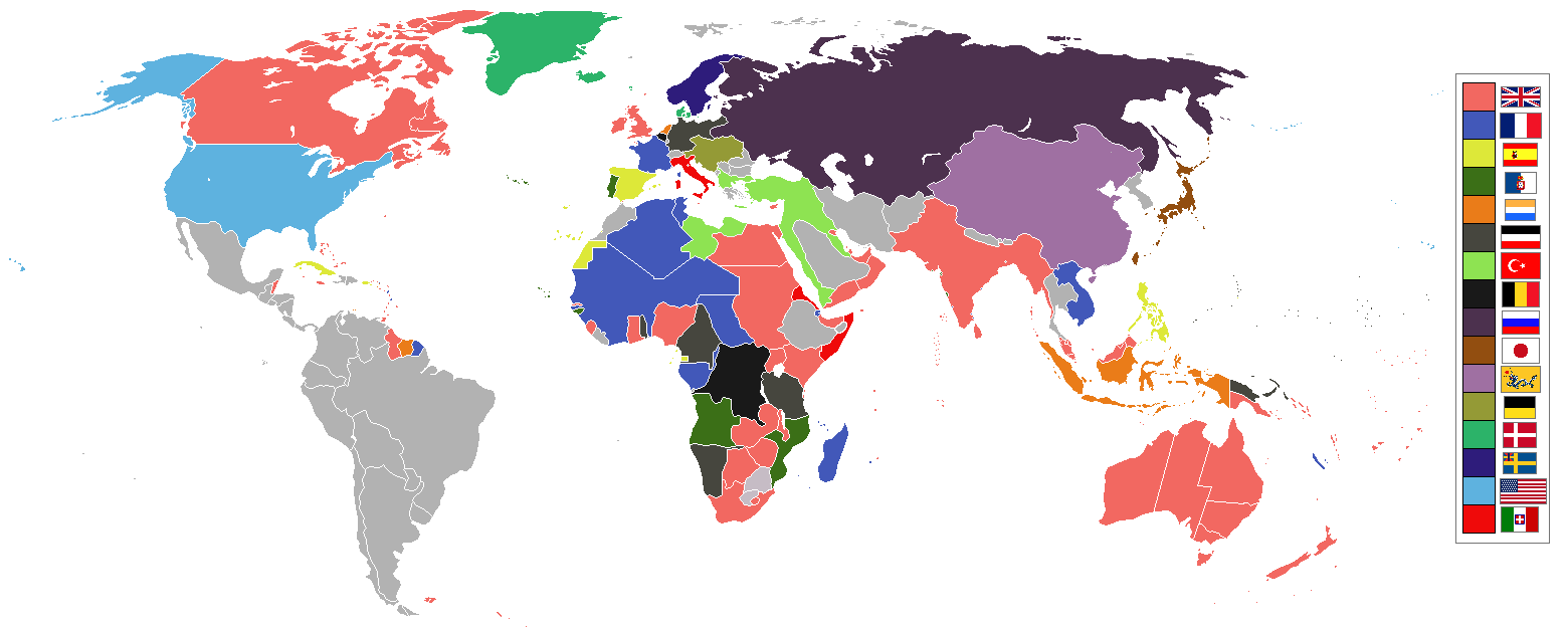
MarVal wrote:Below I have set a little history of the Dutch Empire. I hope the timesettings are correct.

i have a map im planning to use already but thanks anyway i can make sure they both show the same places

Marvaddin wrote:Maaaan, the playability of this map looks simply terrible!

it playability is different
maybe not the type you like but maybe other people would like to play on this map for a change of how you have to play

Posted: Mon Jan 22, 2007 7:41 am
by Qwert
I dont want to tell nothing of rest world only europe.
If you want to create map of empires in age 1914,you got several mistake in europe,Mistake like German empire Austo hungaru empire, Spanis empire, Italian empire,Russian empire, in her acurate borders, and you must have Ottoman empire.

I say for yours qwestion"when the empires where at their biggest" if you mean terittory ,its definitly can done becouse these Empires have to many overlap,example Balkan change empires several times from austro hungary to ottoman empire,and if you put these terittory to ottoman empire you aply these qwestion for these empires,but you dont aply for austro hungary and then these empire will not be in here biggest borders,these i say.

Posted: Mon Jan 22, 2007 8:24 am
by yeti_c
I reckon it should be Empires at what ever state throughout the years...

Some will overlap of course...

Remember that Spain was part of France at one point...

And France was part of Germany of course!!

Are you going to add the Roman empire?

C.

Posted: Mon Jan 22, 2007 12:49 pm
by Telvannia
qwert wrote:I dont want to tell nothing of rest world only europe.
If you want to create map of empires in age 1914,you got several mistake in europe,Mistake like German empire Austo hungaru empire, Spanis empire, Italian empire,Russian empire, in her acurate borders, and you must have Ottoman empire.

area it is really hard to work that bit out


qwert wrote:I say for yours qwestion"when the empires where at their biggest" if you mean terittory ,its definitly can done becouse these Empires have to many overlap,example Balkan change empires several times from austro hungary to ottoman empire,and if you put these terittory to ottoman empire you aply these qwestion for these empires,but you dont aply for austro hungary and then these empire will not be in here biggest borders,these i say.

I would give the countries under dispute to the smaller of the empires who have a claim over it


yeti_c wrote:Are you going to add the Roman empire?

i have decded not to partly because it is at the wrong time for this map
and partly because the roman empire was around when their where nearly no other empires thereby making the map not work

Posted: Mon Jan 22, 2007 3:21 pm
by Qwert
in time 1914 several country become independent of Ottoman empire and dont belong to Austro hungary like you present in yours map.
Serbia -Albania-Montenegro-Romania.
Spain hold northerh Moroco.
Russia hold Large part of Poland,not Germany.
Finland its Russian hold all Finland.

Posted: Mon Jan 22, 2007 3:46 pm
by Telvannia
qwert wrote:in time 1914 several country become independent of Ottoman empire and dont belong to Austro hungary like you present in yours map.
Serbia -Albania-Montenegro-Romania.
Spain hold northerh Moroco.
Russia hold Large part of Poland,not Germany.
Finland its Russian hold all Finland.


I hope you like the updated i have had a go at sorting out europe

Re: WW1 Empires Map **updated 22nd Jan (see 1st post)**

Posted: Mon Jan 22, 2007 4:30 pm
by AndrewB
Telvannia wrote:WW1 Map


How comes that in WW1 Map countries have modern boundaries?

Re: WW1 Empires Map **updated 22nd Jan (see 1st post)**

Posted: Mon Jan 22, 2007 4:53 pm
by Telvannia
AndrewB wrote:
Telvannia wrote:WW1 Map


How comes that in WW1 Map countries have modern boundaries?


because i could not find a WW1 map very quickly
i really should change to a WW1 map then i would be easier

Posted: Mon Jan 22, 2007 5:30 pm
by Telvannia
WW1 map

Image

This is using a the map from WW1 with the right countries shown
only thing is, it groups up empires for example Russia is now one country only rather than many ruled by one leader
do you think i should use the modern map with the empires on or use the WW1 map and break up the countries?

Posted: Mon Jan 22, 2007 5:34 pm
by Guiscard
Use the WWI map and find a map form the period with the correct country markings.

Posted: Mon Jan 22, 2007 7:20 pm
by Qwert
These much beter, I tell only europe.
Still you got 1 mistake, Bulgaria was independent state.

I think Libya was Italian colony,and Egypt was England protectorate.
Do you have neutral country and aly contry and central power too.

Posted: Tue Jan 23, 2007 2:47 am
by Telvannia
Guiscard wrote:Use the WWI map and find a map form the period with the correct country markings.

That map is from the period so i think i will stay with that
but do you think should split russia up or leave it as one country?


qwert wrote:Bulgaria was independent state.

I was not too sure about that i will change it as soon as i have some spare time

qwert wrote:I think Libya was Italian colony,and Egypt was England protectorate.

libya was independant and egypt was a half under british control but i have decided britain is big enough without giving them protectorates

qwert wrote:Do you have neutral country and aly contry and central power too.

i think i might delete neutral countries of the map
and i think that as for making the allies and central powers bonus as well i think it would really make the map odd
so i think i will leave that bit off