Page 10 of 14
Re: High Seas, latest pg. 1 & 13 [I, GP, Gr]
Posted: Sat May 10, 2008 10:48 am
by oaktown
bryguy wrote:I have a question
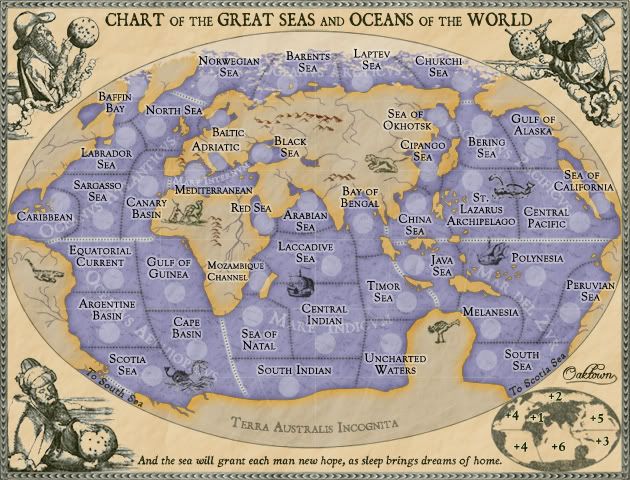
why do the south and scotia sea connect, but not baffin bay and chukchi sea?
Because there was no Northwest Passage in the 16th Century.
Pack ice prevented ships from getting through until an ice breaker did it in the 20th century, and even that took the crew three years. It is navigable now, as a result of climate change.
Re: High Seas, latest pg. 1 & 13 [I, GP, Gr]
Posted: Sat May 10, 2008 11:49 am
by oaktown
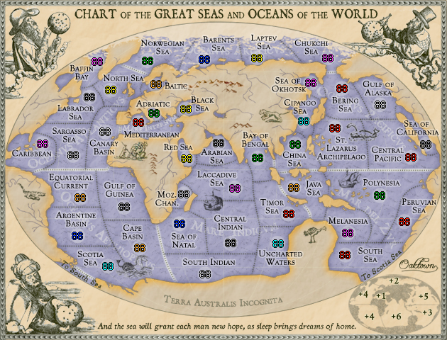
Here are two examples of the large map with army coordinates... small map needs larger circles, so I'll have that up shortly. Note that these are screenshots, and I don't know why the 88s happened to come out look like mud on the first one no matter though as these are for the purpose of centering only. Please tell me what you see off.
88s
[bigimg]http://i141.photobucket.com/albums/r76/ron_parodi/Picture1.png[/bigimg]
888s
[bigimg]http://i141.photobucket.com/albums/r76/ron_parodi/Picture2.png[/bigimg]
Re: High Seas, latest pg. 1 & 13 [I, GP, Gr]
Posted: Sat May 10, 2008 12:43 pm
by TaCktiX
They all look centered to me. Nice work on that oaktown.
Re: High Seas, latest pg. 1 & 13 [I, GP, Gr]
Posted: Sat May 10, 2008 2:04 pm
by oaktown
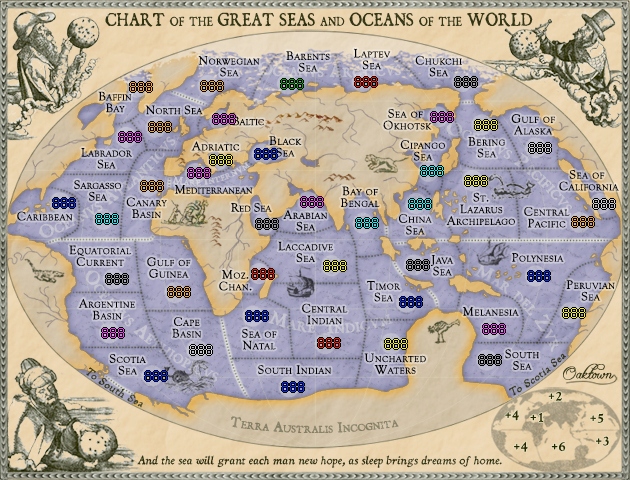
OK, small coordinates... there are a few territories that ain't perfect, kept looking a bit too far to the left or the right, so I went with what looked better to me. If anything looks way off I can recreate individual circles.
To do:
• move the Baltic and Black Sea titles a bit on the small map to get them out from behind the numbers.
• I'll see about darkening up the small map a bit, as Andy suggested.
88s
888s
Re: High Seas, latest pg. 1 & 13 [I, GP, Gr]
Posted: Sat May 10, 2008 2:47 pm
by ZeakCytho
bryguy wrote:I have a question
why do the south and scotia sea connect, but not baffin bay and chukchi sea?
My guess is because of the ice up there. Not exactly easy to sail C16 ships in that area

Re: High Seas, latest pg. 1 & 13 [I, GP, Gr]
Posted: Sat May 10, 2008 3:57 pm
by AndyDufresne
I'm not too fond of the name Moz. Chan. ...mostly because I don't see any other abbreviations...but I do realize that it extended out is probably too big to fit the space. Perhaps if you put Mozambique roofing the army shadow, and Channel along the left side of it---that may work. But it'd look oddly arrange compared to the position of all other names, so it may not be worth it.
A tiny thing, "Sea of California" ... the final "A" is a little off the "world" if that makes sense...perhaps a slight nudge left.
--Andy
Re: High Seas, latest pg. 1 & 13 [I, GP, Gr]
Posted: Sat May 10, 2008 5:41 pm
by oaktown
large map redux
[bigimg]http://i141.photobucket.com/albums/r76/ron_parodi/highseas30.jpg[/bigimg]
small map redux
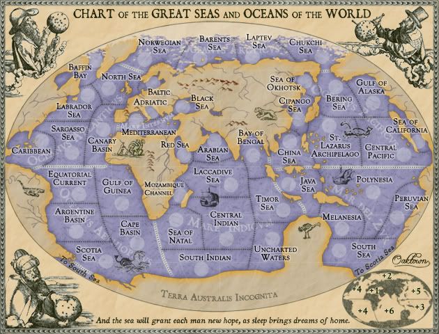
In this version:
• darkened inset map... any darker and it weighs down that corner
• Moz. Chan. is now spelled out; solution was to use a smaller type size
• Sea of California nudged back into map
• Titles that bumped into army counts readjusted
To do: adjust coordinates to match changes.
Re: High Seas, latest pg. 1 & 13 [I, GP, Gr]
Posted: Sat May 10, 2008 5:44 pm
by ZeakCytho
I don't like the new Mozambique Channel, but I guess there isn't really a better way to do it. The rest of the changes look good/
Re: High Seas, latest pg. 1 & 13 [I, GP, Gr]
Posted: Sat May 10, 2008 5:50 pm
by oaktown
Is it time for a code check??
Code: Select all
<?xml version="1.0"?>
<map>
   <title>High Seas</title>
   <smallwidth>630</smallwidth>
   <smallheight>480</smallheight>
   <largewidth>800</largewidth>
   <largeheight>610</largeheight>
   <filetype>jpg</filetype>

   <continent>
      <name>Mar del Zur</name>
      <bonus>3</bonus>
      <components>
         <territory>Polynesia</territory>
         <territory>Peruvian Sea</territory>
         <territory>Melanesia</territory>
         <territory>Java Sea</territory>
         <territory>South Sea</territory>
      </components>
   </continent>

   <continent>
      <name>Oceanus Pacificus</name>
      <bonus>5</bonus>
      <components>
         <territory>Sea of California</territory>
         <territory>Gulf of Alaska</territory>
         <territory>Bering Sea</territory>
         <territory>Cipango Sea</territory>
         <territory>China Sea</territory>
         <territory>St. Lazarus Archipelago</territory>
         <territory>Sea of Okhotsk</territory>
         <territory>Central Pacific</territory>
         </components>
   </continent>

   <continent>
      <name>Oceanus Arcticus</name>
      <bonus>2</bonus>
      <components>
         <territory>Chukchi Sea</territory>
         <territory>Laptev Sea</territory>
         <territory>Barents Sea</territory>
         <territory>Norwegian Sea</territory>
      </components>
   </continent>

   <continent>
      <name>Mare Indicum</name>
      <bonus>6</bonus>
      <components>
         <territory>Timor Sea</territory>
         <territory>Bay of Bengal</territory>
         <territory>Arabian Sea</territory>
         <territory>Laccadive Sea</territory>
         <territory>Mozambique Channel</territory>
         <territory>Sea of Natal</territory>
         <territory>Central Indian Ocean</territory>
         <territory>South Indian Ocean</territory>
         <territory>Uncharted Waters</territory>
         <territory>Red Sea</territory>
      </components>
   </continent>

   <continent>
      <name>Mare Internum</name>
      <bonus>1</bonus>
      <components>
         <territory>Mediterranean</territory>
         <territory>Black Sea</territory>
         <territory>Adriatic</territory>
      </components>
   </continent>

   <continent>
      <name>Oceanus Aethiopicus</name>
      <bonus>4</bonus>
      <components>
         <territory>Scotia Sea</territory>
         <territory>Cape Basin</territory>
         <territory>Gulf of Guinea</territory>
         <territory>Equatorial Current</territory>
         <territory>Argentine Basin</territory>
      </components>
   </continent>

   <continent>
      <name>Oceanus Atlanticus</name>
      <bonus>4</bonus>
      <components>
         <territory>Canary Basin</territory>
         <territory>Baltic</territory>
         <territory>North Sea</territory>
         <territory>Baffin Bay</territory>
         <territory>Labrador Sea</territory>
         <territory>Sargasso Sea</territory>
         <territory>Caribbean</territory>
      </components>
   </continent>

   <territory>
      <name>Baffin Bay</name>
      <borders>
         <border>Labrador Sea</border>
         <border>North Sea</border>
      </borders>
      <coordinates>
         <smallx>133</smallx>
         <smally>109</smally>
         <largex>170</largex>
         <largey>133</largey>

      </coordinates>
   </territory>
   <territory>
      <name>North Sea</name>
      <borders>
         <border>Labrador Sea</border>
         <border>Canary Basin</border>
         <border>Norwegian Sea</border>
         <border>Baltic</border>
         <border>Baffin Bay</border>
      </borders>
      <coordinates>
         <smallx>152</smallx>
         <smally>149</smally>
         <largex>194</largex>
         <largey>184</largey>

      </coordinates>
   </territory>
   <territory>
      <name>Baltic</name>
      <borders>
         <border>North Sea</border>
      </borders>
      <coordinates>
         <smallx>216</smallx>
         <smally>141</smally>
         <largex>275</largex>
         <largey>174</largey>
      </coordinates>
   </territory>
   <territory>
      <name>Labrador Sea</name>
      <borders>
         <border>Baffin Bay</border>
         <border>North Sea</border>
         <border>Canary Basin</border>
         <border>Sargasso Sea</border>
      </borders>
      <coordinates>
         <smallx>122</smallx>
         <smally>159</smally>
         <largex>156</largex>
         <largey>197</largey>
</coordinates>
   </territory>
   <territory>
      <name>Sargasso Sea</name>
      <borders>
         <border>Caribbean</border>
         <border>Labrador Sea</border>
         <border>Canary Basin</border>
         <border>Equatorial Current</border>
      </borders>
      <coordinates>
         <smallx>99</smallx>
         <smally>241</smally>
         <largex>127</largex>
         <largey>301</largey>
      </coordinates>
   </territory>
   <territory>
      <name>Canary Basin</name>
      <borders>
         <border>Sargasso Sea</border>
         <border>Labrador Sea</border>
         <border>Mediterranean</border>
         <border>North Sea</border>
         <border>Equatorial Current</border>
         <border>Gulf of Guinea</border>
      </borders>
      <coordinates>
         <smallx>144</smallx>
         <smally>208</smally>
         <largex>184</largex>
         <largey>259</largey>
      </coordinates>
   </territory>
   <territory>
      <name>Caribbean</name>
      <borders>
         <border>Sargasso Sea</border>
         <border>Equatorial Current</border>
      </borders>
      <coordinates>
         <smallx>56</smallx>
         <smally>225</smally>
         <largex>72</largex>
         <largey>280</largey>
      </coordinates>
   </territory>

   <territory>
      <name>Equatorial Current</name>
      <borders>
         <border>Caribbean</border>
         <border>Sargasso Sea</border>
         <border>Canary Basin</border>
         <border>Gulf of Guinea</border>
         <border>Argentine Basin</border>
      </borders>
      <coordinates>
         <smallx>109</smallx>
         <smally>301</smally>
         <largex>140</largex>
         <largey>377</largey>
      </coordinates>
   </territory>
   <territory>
      <name>Gulf of Guinea</name>
      <borders>
         <border>Equatorial Current</border>
         <border>Argentine Basin</border>
         <border>Canary Basin</border>
         <border>Cape Basin</border>
      </borders>
      <coordinates>
         <smallx>171</smallx>
         <smally>314</smally>
         <largex>218</largex>
         <largey>393</largey>
      </coordinates>
   </territory>
   <territory>
      <name>Cape Basin</name>
      <borders>
         <border>Gulf of Guinea</border>
         <border>Argentine Basin</border>
         <border>Scotia Sea</border>
         <border>Sea of Natal</border>
         <border>South Indian Ocean</border>
      </borders>
      <coordinates>
         <smallx>193</smallx>
         <smally>372</smally>
         <largex>246</largex>
         <largey>467</largey>
      </coordinates>
   </territory>
   <territory>
      <name>Argentine Basin</name>
      <borders>
         <border>Scotia Sea</border>
         <border>Cape Basin</border>
         <border>Gulf of Guinea</border>
         <border>Equatorial Current</border>
      </borders>
      <coordinates>
         <smallx>105</smallx>
         <smally>355</smally>
         <largex>135</largex>
         <largey>445</largey>
      </coordinates>
   </territory>
   <territory>
      <name>Scotia Sea</name>
      <borders>
         <border>Argentine Basin</border>
         <border>Cape Basin</border>
         <border>South Sea</border>
      </borders>
      <coordinates>
         <smallx>148</smallx>
         <smally>398</smally>
         <largex>189</largex>
         <largey>500</largey>
      </coordinates>
   </territory>

   <territory>
      <name>Mediterranean</name>
      <borders>
         <border>Black Sea</border>
         <border>Adriatic</border>
         <border>Canary Basin</border>
      </borders>
      <coordinates>
         <smallx>191</smallx>
         <smally>195</smally>
         <largex>244</largex>
         <largey>243</largey>
      </coordinates>
   </territory>
   <territory>
      <name>Black Sea</name>
      <borders>
         <border>Mediterranean</border>
      </borders>
      <coordinates>
         <smallx>258</smallx>
         <smally>176</smally>
         <largex>329</largex>
         <largey>218</largey>
      </coordinates>
   </territory>
   <territory>
      <name>Adriatic</name>
      <borders>
         <border>Mediterranean</border>
      </borders>
      <coordinates>
         <smallx>213</smallx>
         <smally>182</smally>
         <largex>272</largex>
         <largey>226</largey>
      </coordinates>
   </territory>

   <territory>
      <name>Norwegian Sea</name>
      <borders>
         <border>North Sea</border>
         <border>Barents Sea</border>
      </borders>
      <coordinates>
         <smallx>204</smallx>
         <smally>108</smally>
         <largex>260</largex>
         <largey>131</largey>
      </coordinates>
   </territory>
   <territory>
      <name>Barents Sea</name>
      <borders>
         <border>Norwegian Sea</border>
         <border>Laptev Sea</border>
      </borders>
      <coordinates>
         <smallx>284</smallx>
         <smally>106</smally>
         <largex>361</largex>
         <largey>129</largey>
      </coordinates>
   </territory>
   <territory>
      <name>Laptev Sea</name>
      <borders>
         <border>Barents Sea</border>
         <border>Chukchi Sea</border>
      </borders>
      <coordinates>
         <smallx>358</smallx>
         <smally>104</smally>
         <largex>456</largex>
         <largey>126</largey>
      </coordinates>
   </territory>
   <territory>
      <name>Chukchi Sea</name>
      <borders>
         <border>Bering Sea</border>
         <border>Laptev Sea</border>
      </borders>
      <coordinates>
         <smallx>458</smallx>
         <smally>104</smally>
         <largex>583</largex>
         <largey>126</largey>
      </coordinates>
   </territory>

   <territory>
      <name>Bering Sea</name>
      <borders>
         <border>Chukchi Sea</border>
         <border>Gulf of Alaska</border>
         <border>Sea of Okhotsk</border>
         <border>St. Lazarus Archipelago</border>
         <border>Central Pacific</border>
      </borders>
      <coordinates>
         <smallx>478</smallx>
         <smally>147</smally>
         <largex>608</largex>
         <largey>181</largey>
      </coordinates>
   </territory>
   <territory>
      <name>Sea of Okhotsk</name>
      <borders>
         <border>Cipango Sea</border>
         <border>Bering Sea</border>
      </borders>
      <coordinates>
         <smallx>434</smallx>
         <smally>139</smally>
         <largex>552</largex>
         <largey>171</largey>
      </coordinates>
   </territory>
   <territory>
      <name>Gulf of Alaska</name>
      <borders>
         <border>Bering Sea</border>
         <border>Sea of California</border>
         <border>Central Pacific</border>
      </borders>
      <coordinates>
         <smallx>532</smallx>
         <smally>170</smally>
         <largex>676</largex>
         <largey>210</largey>
      </coordinates>
   </territory>
   <territory>
      <name>Cipango Sea</name>
      <borders>
         <border>Sea of Okhotsk</border>
         <border>St. Lazarus Archipelago</border>
         <border>China Sea</border>
      </borders>
      <coordinates>
         <smallx>424</smallx>
         <smally>193</smally>
         <largex>540</largex>
         <largey>240</largey>
      </coordinates>
   </territory>
   <territory>
      <name>Central Pacific</name>
      <borders>
         <border>Sea of California</border>
         <border>Bering Sea</border>
         <border>Gulf of Alaska</border>
         <border>St. Lazarus Archipelago</border>
         <border>Polynesia</border>
      </borders>
      <coordinates>
         <smallx>575</smallx>
         <smally>244</smally>
         <largex>732</largex>
         <largey>305</largey>
      </coordinates>
   </territory>
   <territory>
      <name>St. Lazarus Archipelago</name>
      <borders>
         <border>Central Pacific</border>
         <border>Bering Sea</border>
         <border>Cipango Sea</border>
         <border>China Sea</border>
         <border>Polynesia</border>
      </borders>
      <coordinates>
         <smallx>468</smallx>
         <smally>203</smally>
         <largex>596</largex>
         <largey>252</largey>
      </coordinates>
   </territory>
   <territory>
      <name>China Sea</name>
      <borders>
         <border>Bay of Bengal</border>
         <border>Java Sea</border>
         <border>St. Lazarus Archipelago</border>
         <border>Cipango Sea</border>
      </borders>
      <coordinates>
         <smallx>412</smallx>
         <smally>226</smally>
         <largex>524</largex>
         <largey>281</largey>
      </coordinates>
   </territory>
   <territory>
      <name>Sea of California</name>
      <borders>
         <border>Gulf of Alaska</border>
         <border>Central Pacific</border>
      </borders>
      <coordinates>
         <smallx>596</smallx>
         <smally>226</smally>
         <largex>758</largex>
         <largey>281</largey>
      </coordinates>
   </territory>

   <territory>
      <name>Polynesia</name>
      <borders>
         <border>Central Pacific</border>
         <border>St. Lazarus Archipelago</border>
         <border>Melanesia</border>
         <border>Peruvian Sea</border>
         <border>South Sea</border>
         <border>Java Sea</border>
      </borders>
      <coordinates>
         <smallx>531</smallx>
         <smally>298</smally>
         <largex>676</largex>
         <largey>373</largey>
      </coordinates>
   </territory>
   <territory>
      <name>Melanesia</name>
      <borders>
         <border>Java Sea</border>
         <border>Polynesia</border>
         <border>South Sea</border>
      </borders>
      <coordinates>
         <smallx>486</smallx>
         <smally>351</smally>
         <largex>619</largex>
         <largey>440</largey>
      </coordinates>
   </territory>
   <territory>
      <name>Java Sea</name>
      <borders>
         <border>China Sea</border>
         <border>Polynesia</border>
         <border>Melanesia</border>
         <border>Timor Sea</border>
      </borders>
      <coordinates>
         <smallx>410</smallx>
         <smally>287</smally>
         <largex>522</largex>
         <largey>359</largey>
      </coordinates>
   </territory>
   <territory>
      <name>South Sea</name>
      <borders>
         <border>Scotia Sea</border>
         <border>Peruvian Sea</border>
         <border>Polynesia</border>
         <border>Melanesia</border>
      </borders>
      <coordinates>
         <smallx>482</smallx>
         <smally>382</smally>
         <largex>614</largex>
         <largey>480</largey>
      </coordinates>
   </territory>
   <territory>
      <name>Peruvian Sea</name>
      <borders>
         <border>Polynesia</border>
         <border>South Sea</border>
      </borders>
      <coordinates>
         <smallx>566</smallx>
         <smally>335</smally>
         <largex>720</largex>
         <largey>420</largey>
      </coordinates>
   </territory>

   <territory>
      <name>Bay of Bengal</name>
      <borders>
         <border>Timor Sea</border>
         <border>Laccadive Sea</border>
         <border>China Sea</border>
      </borders>
      <coordinates>
         <smallx>359</smallx>
         <smally>245</smally>
         <largex>457</largex>
         <largey>306</largey>
      </coordinates>
   </territory>
   <territory>
      <name>Arabian Sea</name>
      <borders>
         <border>Red Sea</border>
         <border>Laccadive Sea</border>
      </borders>
      <coordinates>
         <smallx>304</smallx>
         <smally>224</smally>
         <largex>387</largex>
         <largey>279</largey>
      </coordinates>
   </territory>
   <territory>
      <name>Mozambique Channel</name>
      <borders>
         <border>Laccadive Sea</border>
         <border>Sea of Natal</border>
      </borders>
      <coordinates>
         <smallx>255</smallx>
         <smally>303</smally>
         <largex>323</largex>
         <largey>380</largey>
      </coordinates>
   </territory>
   <territory>
      <name>Sea of Natal</name>
      <borders>
         <border>Cape Basin</border>
         <border>Mozambique Channel</border>
         <border>Central Indian Ocean</border>
         <border>South Indian Ocean</border>
      </borders>
      <coordinates>
         <smallx>249</smallx>
         <smally>338</smally>
         <largex>317</largex>
         <largey>424</largey>
      </coordinates>
   </territory>
   <territory>
      <name>South Indian Ocean</name>
      <borders>
         <border>Sea of Natal</border>
         <border>Central Indian Ocean</border>
         <border>Uncharted Waters</border>
         <border>Cape Basin</border>
      </borders>
      <coordinates>
         <smallx>285</smallx>
         <smally>409</smally>
         <largex>363</largex>
         <largey>514</largey>
      </coordinates>
   </territory>
   <territory>
      <name>Uncharted Waters</name>
      <borders>
         <border>South Indian Ocean</border>
         <border>Central Indian Ocean</border>
         <border>Timor Sea</border>
      </borders>
      <coordinates>
         <smallx>388</smallx>
         <smally>366</smally>
         <largex>493</largex>
         <largey>459</largey>
      </coordinates>
   </territory>
   <territory>
      <name>Timor Sea</name>
      <borders>
         <border>Java Sea</border>
         <border>Uncharted Waters</border>
         <border>Bay of Bengal</border>
         <border>Laccadive Sea</border>
         <border>Central Indian Ocean</border>
      </borders>
      <coordinates>
         <smallx>403</smallx>
         <smally>324</smally>
         <largex>512</largex>
         <largey>406</largey>
      </coordinates>
   </territory>
   <territory>
      <name>Central Indian Ocean</name>
      <borders>
         <border>Laccadive Sea</border>
         <border>Timor Sea</border>
         <border>Uncharted Waters</border>
         <border>South Indian Ocean</border>
         <border>Sea of Natal</border>
      </borders>
      <coordinates>
         <smallx>321</smallx>
         <smally>365</smally>
         <largex>409</largex>
         <largey>459</largey>
      </coordinates>
   </territory>
   <territory>
      <name>Laccadive Sea</name>
      <borders>
         <border>Arabian Sea</border>
         <border>Bay of Bengal</border>
         <border>Red Sea</border>
         <border>Timor Sea</border>
         <border>Central Indian Ocean</border>
         <border>Mozambique Channel</border>
      </borders>
      <coordinates>
         <smallx>327</smallx>
         <smally>288</smally>
         <largex>417</largex>
         <largey>360</largey>
      </coordinates>
   </territory>
   <territory>
      <name>Red Sea</name>
      <borders>
         <border>Arabian Sea</border>
         <border>Laccadive Sea</border>
      </borders>
      <coordinates>
         <smallx>259</smallx>
         <smally>246</smally>
         <largex>331</largex>
         <largey>307</largey>
      </coordinates>
   </territory>
</map>
Re: High Seas, latest pg. 1 & 13 [I, GP, Gr]
Posted: Sat May 10, 2008 5:59 pm
by oaktown
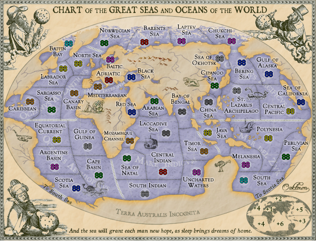
updates with 88s.
[bigimg]http://i141.photobucket.com/albums/r76/ron_parodi/Picture6.png[/bigimg]
Re: High Seas, code and counts pg 16 [I, GP, Gr]
Posted: Sun May 11, 2008 5:35 am
by Forza AZ
No mistakes found in the XML.
Re: High Seas, latest pg. 1 & 13 [I, GP, Gr]
Posted: Sun May 11, 2008 3:49 pm
by yeti_c
bryguy wrote:I have a question
why do the south and scotia sea connect, but not baffin bay and chukchi sea?
Probably cos of the big bit of ice in the way?!
C.
Re: High Seas, code and counts pg 16 [I, GP, Gr]
Posted: Sun May 11, 2008 8:23 pm
by gimil
Oaktown there is always something about your maps that feel more complete than other maps. I live it.
But whatever is going on in north africa looks to busy to me, would it be to much to do something with it (even thou im not sure what)

Re: High Seas, code and counts pg 16 [I, GP, Gr]
Posted: Sun May 11, 2008 10:56 pm
by oaktown
gimil wrote:But whatever is going on in north africa looks to busy to me, would it be to much to do something with it (even thou im not sure what)
I'd love to do something about whatever it is that is bothering you, gim. I'm trying to read your mind to figure out what that is, but there must be something between us that is keeping me from picking up your thoughts... what could it be... Oceanus Atlanticus perhaps?
Re: High Seas, code and counts pg 16 [I, GP, Gr]
Posted: Mon May 12, 2008 8:11 pm
by gimil
Maybe jsut remove the river you got running through the picture of people (is that what they are?). I think ill be satisfied

Re: High Seas, code and counts pg 16 [I, GP, Gr]
Posted: Mon May 12, 2008 9:34 pm
by oaktown
gimil wrote:Maybe jsut remove the river you got running through the picture of people (is that what they are?). I think ill be satisfied
Hmm... are people having trouble making out the camels? If so I should swap out that image for something completely different.
Re: High Seas, code and counts pg 16 [I, GP, Gr]
Posted: Mon May 12, 2008 9:35 pm
by ZeakCytho
oaktown wrote:gimil wrote:Maybe jsut remove the river you got running through the picture of people (is that what they are?). I think ill be satisfied
Hmm... are people having trouble making out the camels? If so I should swap out that image for something completely different.
Those things are camels!? The whole picture makes a lot more sense now
Seriously, I had no idea what they were. I guess another image would be good, though I kind of like this one now that I know what it is.
Re: High Seas, code and counts pg 16 [I, GP, Gr]
Posted: Mon May 12, 2008 9:42 pm
by oaktown
ZeakCytho wrote:Those things are camels!? The whole picture makes a lot more sense now
Man, you send 'em to school, you buy 'em books...

Tell ya what I'll do - I'll lose the second camel and make it easier to make out.
Re: High Seas, code and counts pg 16 [I, GP, Gr]
Posted: Mon May 12, 2008 11:54 pm
by oaktown
All right... how d'you like them camels?
[bigimg]http://i141.photobucket.com/albums/r76/ron_parodi/highseas31.jpg[/bigimg]
Re: High Seas, code and counts pg 16 [I, GP, Gr]
Posted: Mon May 12, 2008 11:57 pm
by ZeakCytho
That is one damned fine camel, Oaktown

See, I can be taught

.
Re: High Seas, code and counts pg 16 [I, GP, Gr]
Posted: Tue May 13, 2008 12:02 am
by AndyDufresne
If we are going to change various images on the map, what about adding a Kraken?
(There's no room really, I just like the old sea creature.
)
--Andy
Re: High Seas, code and counts pg 16 [I, GP, Gr]
Posted: Tue May 13, 2008 12:04 am
by ZeakCytho
AndyDufresne wrote:If we are going to change various images on the map, what about adding a Kraken?
(There's no room really, I just like the old sea creature.
)
--Andy
That thing between the Scotia Sea and Cape Basin looks vaguely Kraken-ish. It could pass for one
Re: High Seas, code and counts pg 16 [I, GP, Gr]
Posted: Tue May 13, 2008 12:06 am
by AndyDufresne
It in no way resembles a Kraken. Pretty sure it's a 'seahorse.'
--Andy
Re: High Seas, code and counts pg 16 [I, GP, Gr]
Posted: Tue May 13, 2008 12:08 am
by ZeakCytho
AndyDufresne wrote:It in no way resembles a Kraken. Pretty sure it's a 'seahorse.'
--Andy
Hmm...now that you mention it, I didn't notice the right/bottom line on that thing's neck, making me think that it's whole right half was tentacles, hence the Kraken.
I think this proves that either I have worse eyesight than I thought, a more overactive imagination than I thought, or that Oaktown doesn't draw very clear mythical creatures.
Re: High Seas, code and counts pg 16 [I, GP, Gr]
Posted: Tue May 13, 2008 12:18 am
by oaktown
Any more jokes about my drawings and I'll tell you all what you can stick up your krakens...