Page 8 of 39
umm
Posted: Thu Dec 06, 2007 5:42 pm
by WL_southerner
umm wiltshire in an inland county and has no coast
Re: umm
Posted: Thu Dec 06, 2007 5:44 pm
by gimil
WL_southerner wrote:umm wiltshire in an inland county and has no coast
That requirered a slight boarder tweek to keep gameplay the sameme.
umm
Posted: Thu Dec 06, 2007 5:47 pm
by WL_southerner
could make it somerset & wiltshire, seeing that somerset is a bigger country than wiltshire
Re: umm
Posted: Thu Dec 06, 2007 5:49 pm
by gimil
WL_southerner wrote:could make it somerset & wiltshire
were trying to get away from the doubles terr names.
umm
Posted: Thu Dec 06, 2007 5:53 pm
by WL_southerner
i can see your point but the there are real double name in life,like hampshire & isles of wrigt is refered to has one isle wrigt is a sub council of hampshire
Re: umm
Posted: Thu Dec 06, 2007 5:54 pm
by gimil
WL_southerner wrote:i can see your point but the there are real double name in life,like hampshire & isles of wrigt is refered to has one isle wrigt is a sub council of hampshire
Im aware but if possible im trying to keep the doubles names to a minimum.
because wicked likes to complain because shes female
Posted: Thu Dec 06, 2007 6:00 pm
by wicked

Well only dumb people call one location two names.

Besides, this isn't real life and double names don't work well on drop down menus.
Posted: Thu Dec 06, 2007 6:05 pm
by gimil
wicked wrote::twisted:
Well only dumb people call one location two names.
Besides, this isn't real life and double names don't work well on drop down menus.
stor with your drop down fettish . . . .
Im sorted the doubles name thing out anyway.
Posted: Thu Dec 06, 2007 6:39 pm
by reverend_kyle
gimil wrote: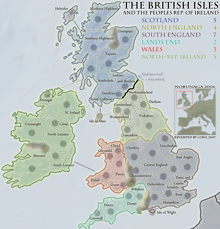
todo
-Final Froge
-Rework south england
-Dont politcally offend rebelman

-WML tweeks
-Make Wicked happy
-Call humley a very very bad word
My suggestions.
1. No double names.
2. New title and legend and drop the peoples republic business as that typically denotes a communist government and Ireland is far from a communist state.
3. Change the name of Ireland in the legend to just "Ireland". As far as I know that is what the Island itself is called and the country is just named after the island. Simliarly to how North Ireland is called north ireland, because it's on the north side of the island and also to differentiate it from the country of Ireland. So I believe if you just call that continent "Ireland" it can be geographically accurate and not offend anyone(I think)
Posted: Thu Dec 06, 2007 6:48 pm
by MeDeFe
Better, although I still miss Cork and Kerry, leaving out the flags was a huge improvement. Now, please change those mountains because they don't just look bad, they're fugly.
Posted: Thu Dec 06, 2007 6:50 pm
by yeti_c
I'm still more concerned with Glos and Chesire bordering each other...
That makes me far too close to Manchester for my liking!
C.
Posted: Thu Dec 06, 2007 6:54 pm
by benjikat
and whilst Central England is used to refer to The Midlands, the latter is much ore widely used. Please use East and West Midlands as sugested by a few people now...
Posted: Thu Dec 06, 2007 7:34 pm
by iancanton
reverend_kyle wrote:I believe if you just call that continent "Ireland" it can be geographically accurate and not offend anyone(I think)
i agree. i can see three ways to solve the irish question. i favour the first of those listed below, though can accept the second or third.
1. use purely geographical terms in the map's title: "great britain and ireland" - "great britain" is the island of great britain and "ireland" is the whole of the island of ireland, both with their offshore islands.
2. use purely political terms in the map's title: "united kingdom and irish republic" - "united kingdom" is great britain (as defined above) plus northern ireland and "irish republic" is the republic of ireland; we must not use "united kingdom and ireland", as northern ireland unionists will feel that we've shoved them into the republic of ireland.
3. set the map at a particular point in history: "british isles AD 1900" - at that time, all of the "british isles" really were british; not only that, but it was (and still is today, except in the irish republic) also a geographical term covering great britain and ireland, both with their offshore islands, plus the isle of man.
all three of the above are correct, whereas "british isles and ireland" includes ireland twice. on the map, we ought to avoid using eire for ireland, since this is an irish gaelic name and, by analogy, we are not using alba for scotland or cymru for wales.
ian.

Posted: Thu Dec 06, 2007 7:51 pm
by rebelman
hulmey wrote:Northern Ireland is not part of Ireland and should not ahve a bonus for being part of Ireland. You should try and be as accurate as possible with this map as espically as you are now having the chance to do just that!
hulmey yes it is part ot the island of Ireland / Éire
Posted: Thu Dec 06, 2007 7:52 pm
by rebelman
iancanton wrote:
1. use purely geographical terms in the map's title: "great britain and ireland" - "great britain" is the island of great britain and "ireland" is the whole of the island of ireland, both with their offshore islands.
pick of the 3 IMHO
Posted: Thu Dec 06, 2007 7:54 pm
by rebelman
hulmey wrote:i dont like the current passables you have at the moment..What can you come up with!
Maybe regards the NI issue you could put the NI flag there or hjust highight that region!
hiulmey 2 flags have legal status in NI the union jack and the tricolour - the flag Gimil used has no legal status in NI since 1973.
Posted: Thu Dec 06, 2007 7:57 pm
by rebelman
hulmey wrote:this map is now being revamped and it hsa unique chance to be revamped correctly. Having NI as part of EIRE is like having Canada as part of the USA!!
It should either be done correctly or not at all!
Now im not saying dont include with the bonus of EIRE. Im just asking for it to be shown in some capacity that is part of England!
It is not part of England

NI is part of Éire as Éire is the name of the island or to use the English form Ireland.
Posted: Thu Dec 06, 2007 8:03 pm
by rebelman
hulmey wrote:
So lets move ona nd get to work. First thing is that Northern Irealnd is not and will never be part of EIRE! if this map is goingt o be accurate, as i think you wish it to be then you need to make the changes it that area! You could also try and imagine a unique bonus scheme for that highly specal provinve of Great Britiain!
Northern Ireland is not a province - it constitutes a portion of the province of Ulster. It is now and always will be part of Éire, as Éire is the name of the island as a whole. If you are referring to what the future holds for this politically sensitive region you must have no knowledge of what was contained in the 1997 good Friday Agreement and the latest population and ethnicity projections for the region.
Posted: Thu Dec 06, 2007 8:08 pm
by reverend_kyle
rebelman wrote:iancanton wrote:
1. use purely geographical terms in the map's title: "great britain and ireland" - "great britain" is the island of great britain and "ireland" is the whole of the island of ireland, both with their offshore islands.
pick of the 3 IMHO
My pick too.. and also I believe British Isles is a shorter term encompassing great britain and Ireland.
Posted: Thu Dec 06, 2007 9:44 pm
by soundout9
I dont like the way the mountains look...should make that brown or something so it stands out more.
Posted: Thu Dec 06, 2007 9:45 pm
by gimil
yeti_c wrote:I'm still more concerned with Glos and Chesire bordering each other...
That makes me far too close to Manchester for my liking!
C.
Polution,
gun crime,
grand theft auto. . .
whats not to like.
Posted: Thu Dec 06, 2007 9:45 pm
by gimil
benjikat wrote:and whilst Central England is used to refer to The Midlands, the latter is much ore widely used. Please use East and West Midlands as sugested by a few people now...
southern englands getting a rework
Posted: Thu Dec 06, 2007 9:48 pm
by gimil
Great Britian and Ireland will do, I wanted british isles to try and keep the map in the same place in game finder. But nevermind.
As for the montains ive changed them.
Posted: Thu Dec 06, 2007 10:24 pm
by I GOT SERVED
I know this has been said before, but rework the mountains. They're down right hideous.
Also, I'd like to see a wall graphic for where Hadrain's Wall is. That'd be cool.
Posted: Thu Dec 06, 2007 10:31 pm
by gimil
I GOT SERVED wrote:I know this has been said before, but rework the mountains. They're down right hideous.
Also, I'd like to see a wall graphic for where Hadrain's Wall is. That'd be cool.
ive already mentioned that ill reork the mountains, and ill put a nice little wall graphics in at some point.