Page 6 of 39
Posted: Wed Dec 05, 2007 5:32 pm
by Blitzaholic
gimil wrote:Blitzaholic wrote:are those the color of the lands you are using?
yes do you like? dislike?
is it flags of their countries? it is creative, i didn't have much issue with the old one and thought it was playable, but this looks neat, may take some awhile to get used to is all. I was hoping for some more color? but thats your choice.
Flags
Posted: Wed Dec 05, 2007 5:41 pm
by Keredrex
If there is still any chance... I liked the Flags in the Territs... They were just too Opaque..... I think if they were Lighter it would perfect
Posted: Wed Dec 05, 2007 7:27 pm
by Nobunaga
... Hi, Guys.
... I gave Gimil the go-ahead with this map revamp for a few reasons.
1: I got more than a few PMs over the years (has it been years? Maybe about a year and a half), people moaning at me about map mistakes.
2: Gimil seems a competent artist. When I made the thing there were only a handful of maps available. Compared to the Middle East map we had back then, mine was a work of art. But now a lot of people have come to CC and there's a lot of talent available, so I figured, why not spruce it up?
3: Gimil agreed to maintain borders and boundaries, which means actual play will not be affected.
4: I really wanted to do it myself, but I just don't have the time.
It's funny. I slapped that map together using any old map I could dig up on the internet for sampling (place names, regions, etc..). I didn't give much thought to playability and balance then. Just dumb luck it turned out OK. I'm very happy enough folks like it enough to talk about the thing here.
... Anyway, that's the scoop. Sure, I'm a bit nostalgic about the thing, too (but I have the original Photoshop files anyway, so I can see it any time I want! )

...
Posted: Wed Dec 05, 2007 8:35 pm
by Incandenza
Like many others, I've grown to like the old-school map. But I understand why nobunaga wants to go through a revamp process.
I'm firmly concur with wicked that the multiple names are a really bad idea. There's geographic accuracy, and then there's clutter. If geographic accuracy in naming makes the map look substantially poorer (as it does now), then accuracy needs to be sacrificed. It's a game board, not a real map. Besides, on Classic, Central America isn't called "Mexico and Central America", even though that would be more accurate than the current name. Similarly, Siam encompasses more than just Thailand. Please pick just one name.
I also greatly prefer the version without flags, especially since, as noted before, they don't correspond to the continents, which is the whole point of the flags on great lakes. Coloring each continent seems to work way better.
Perhaps the problem that people are having with this revamp is that it doesn't seem to be very much in the style of nobunaga's map. Yes, I understand that the gameplay will be exactly the same, but there is a sense of something being lost, especially when we're talking about one of the top five most played maps on the site. This isn't a revamp, it's a complete graphic rebuild.
Posted: Wed Dec 05, 2007 8:57 pm
by jako
but isnt what gimil is doing to the brit ilse map the same as what WM did to the canada map?
they are doing the same radical revamp so y should gimil be forced to stick to the old style?
i am one of the few that like it with flags, but thats just me.
Posted: Thu Dec 06, 2007 4:03 am
by yeti_c
Incandenza wrote:I also greatly prefer the version without flags, especially since, as noted before, they don't correspond to the continents, which is the whole point of the flags on great lakes.
Er... I don't understand this comment...
The flags correspond to the countries that make up the British Isles (and Ireland)...
The English country is split into 3 "continents" but apart from that this works perfectly?!
C.
Posted: Thu Dec 06, 2007 10:15 am
by reverend_kyle
yeti_c wrote:Incandenza wrote:I also greatly prefer the version without flags, especially since, as noted before, they don't correspond to the continents, which is the whole point of the flags on great lakes.
Er... I don't understand this comment...
The flags correspond to the countries that make up the British Isles (and Ireland)...
The English country is split into 3 "continents" but apart from that this works perfectly?!
C.
I think he was talking about that with england being split into 3 continents, and then ireland being one continent and having 2 flags. It gets confusing.
Posted: Thu Dec 06, 2007 11:35 am
by hulmey
Nob, why try and revamp/fix the map when it aint broken. Ok so there are a few geographical mistakes regards this map. But people still love it and it is one of the most used and loved maps on CC. Don't fix what isnt broken!
Posted: Thu Dec 06, 2007 11:58 am
by gimil
hulmey wrote:Nob, why try and revamp/fix the map when it aint broken. Ok so there are a few geographical mistakes regards this map. But people still love it and it is one of the most used and loved maps on CC. Don't fix what isnt broken!
Evidently there has been high numbers of complains about the graphics and geographic inaccuracy. MAKING it broke, ever the British Isles carto said he had recieved large volumes of PM complaining about it over hte years. Now that he had accepted a revamp so you wither have to live with it or not play the new mao once reliesesd.
But with the number of complaints that he has recieved its a surprise that he never pulled the map from the site.
Posted: Thu Dec 06, 2007 12:04 pm
by wicked
Guys, gimmie isn't going to get anywhere if he keeps having to answer "why fix it?" every other post. Nobu (the original mapmaker) has come on here and said he'd like it fixed, ergo it'll be fixed. So instead of complaining that it shouldn't be done, how about offering suggestions on what should be done so that everyone is happy with the final product?
I think it's obvious now that I'm not the only one who disagrees with the double names. Someone mentioned you could possibly just slide some borders around to make it a bit more accurate w/o changing the gameplay? Am I remembering that correctly?
Another point brought up by a couple people is the font of the ocean names. Can you look at some different options there?
Posted: Thu Dec 06, 2007 12:07 pm
by gimil
wicked wrote:Guys, gimmie isn't going to get anywhere if he keeps having to answer "why fix it?" every other post. Nobu (the original mapmaker) has come on here and said he'd like it fixed, ergo it'll be fixed. So instead of complaining that it shouldn't be done, how about offering suggestions on what should be done so that everyone is happy with the final product?
I think it's obvious now that I'm not the only one who disagrees with the double names. Someone mentioned you could possibly just slide some borders around to make it a bit more accurate w/o changing the gameplay? Am I remembering that correctly?
Another point brought up by a couple people is the font of the ocean names. Can you look at some different options there?
Im going o take a look at some of the doubles names, some will be kept thou because they are commonly refered to by those names e.g. lothian and boarders, dumfries and gallowway etc. Would abrev names be an option you guys?
Posted: Thu Dec 06, 2007 12:08 pm
by gimil
p.s i like it when wicked calls me gimmie

Posted: Thu Dec 06, 2007 12:14 pm
by rebelman
If you got rid of the inaccurate / offensive map title and sorted out the Irish geography as per my ealier posts I for one would be happy.
Posted: Thu Dec 06, 2007 12:14 pm
by wicked
gimil wrote:Im going o take a look at some of the doubles names, some will be kept thou because they are commonly refered to by those names e.g. lothian and boarders, dumfries and gallowway etc. Would abrev names be an option you guys?
Are they really called that IRL? Surely not everyone runs around calling them both names?
Posted: Thu Dec 06, 2007 12:31 pm
by gimil
wicked wrote:gimil wrote:Im going o take a look at some of the doubles names, some will be kept thou because they are commonly refered to by those names e.g. lothian and boarders, dumfries and gallowway etc. Would abrev names be an option you guys?
Are they really called that IRL? Surely not everyone runs around calling them both names?
Honestly dumfries and gallowy and lothian and boarders tend to stich by those names (Check continent names in scotland map)
Posted: Thu Dec 06, 2007 12:32 pm
by gimil
rebelman wrote:If you got rid of the inaccurate / offensive map title and sorted out the Irish geography as per my ealier posts I for one would be happy.
Ive changed the title on the map to include the people rep. of ireland.
Posted: Thu Dec 06, 2007 12:35 pm
by gimil
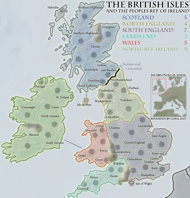
iancanton wrote:below is my concept of where to draw the borders in southern england (plus lancashire) to produce identical gameplay together with geographical accuracy and the least strange-shaped territories. thanks to yeti_c for the political map on page 8. gimil, is this list of any help to u?
kent
isle of wight
home counties south (currently "sussex and hampshire"): surrey, sussex and hampshire
home counties north (currently "oxfordshire"): oxfordshire, berkshire, buckinghamshire, hertfordshire, middlesex and bedfordshire
london and essex (currently "london")
cambridgeshire and suffolk (currently "essex and cambridgeshire")
norfolk (currently "east anglia")
lincolnshire
east midlands (currently "central england"): derbyshire, nottinghamshire, leicestershire, rutland and northamptonshire
west midlands or west mercia (currently "cheshire"): shropshire, staffordshire, warwickshire, herefordshire and worcestershire
gloucestershire
lancashire and cheshire (currently "lancashire")
ian.

This i will do
Posted: Thu Dec 06, 2007 12:48 pm
by benjikat
iancanton wrote:below is my concept of where to draw the borders in southern england (plus lancashire) to produce identical gameplay together with geographical accuracy and the least strange-shaped territories. thanks to yeti_c for the political map on page 8. gimil, is this list of any help to u?
kent
isle of wight
home counties south (currently "sussex and hampshire"): surrey, sussex and hampshire
home counties north (currently "oxfordshire"): oxfordshire, berkshire, buckinghamshire, hertfordshire, middlesex and bedfordshire
london and essex (currently "london")
cambridgeshire and suffolk (currently "essex and cambridgeshire")
norfolk (currently "east anglia")
lincolnshire
east midlands (currently "central england"): derbyshire, nottinghamshire, leicestershire, rutland and northamptonshire
west midlands or west mercia (currently "cheshire"): shropshire, staffordshire, warwickshire, herefordshire and worcestershire
gloucestershire
lancashire and cheshire (currently "lancashire")
ian.
These I like - but stick to West Midlands.
Posted: Thu Dec 06, 2007 12:55 pm
by Ogrecrusher
I have a suggestion. Could you use the river Shannon as the Impassable in Ireland?
Posted: Thu Dec 06, 2007 1:00 pm
by gimil
Ogrecrusher wrote:I have a suggestion. Could you use the river Shannon as the Impassable in Ireland?
Where is it located?
Posted: Thu Dec 06, 2007 1:06 pm
by rebelman
gimil wrote:Ogrecrusher wrote:I have a suggestion. Could you use the river Shannon as the Impassable in Ireland?
Where is it located?

you could always shorten it a bit

Posted: Thu Dec 06, 2007 1:14 pm
by gimil
todo
-Final Froge
-Rework south england
-Dont politcally offend rebelman
-WML tweeks
-Make Wicked happy
-Call humley a very very bad word
Posted: Thu Dec 06, 2007 1:14 pm
by gimil
rebelman wrote:gimil wrote:Ogrecrusher wrote:I have a suggestion. Could you use the river Shannon as the Impassable in Ireland?
Where is it located?
you could always shorten it a bit
I will use hte river to replace the montain
Posted: Thu Dec 06, 2007 1:20 pm
by rebelman
despite what my profile location says its just the "Republic of Ireland" or what might look much neater and tidier is "Éire"
As mentioned previously can you please change Cavan to Cavan/Monaghan
Posted: Thu Dec 06, 2007 1:22 pm
by gimil
rebelman wrote:despite what my profile location says its just the "Republic of Ireland" or what might look much neater and tidier is "Éire"
Im aware but hte people reuplic of ireland dounded and looked good. would you prefer Éire? of just hte republic of ireland?