Posted: Sun Jan 06, 2008 11:09 am
Lone.prophet wrote:The colors are chosen with a reason, and if people can read blue armies on the classic map they can read this.
you just dont listen do you?
Conquer Club, a free online multiplayer variation of a popular world domination board game.
http://www.tools.conquerclub.com/forum2/
http://www.tools.conquerclub.com/forum2/viewtopic.php?t=10397
Lone.prophet wrote:The colors are chosen with a reason, and if people can read blue armies on the classic map they can read this.
Lone.prophet wrote:The colors are chosen with a reason, and if people can read blue armies on the classic map they can read this.
Lone.prophet wrote:Now noboady can whine anymore
rebelman wrote:Lone.prophet wrote:Now noboady can whine anymore
issue resolved but it would take a lot more than that to end whineing in general
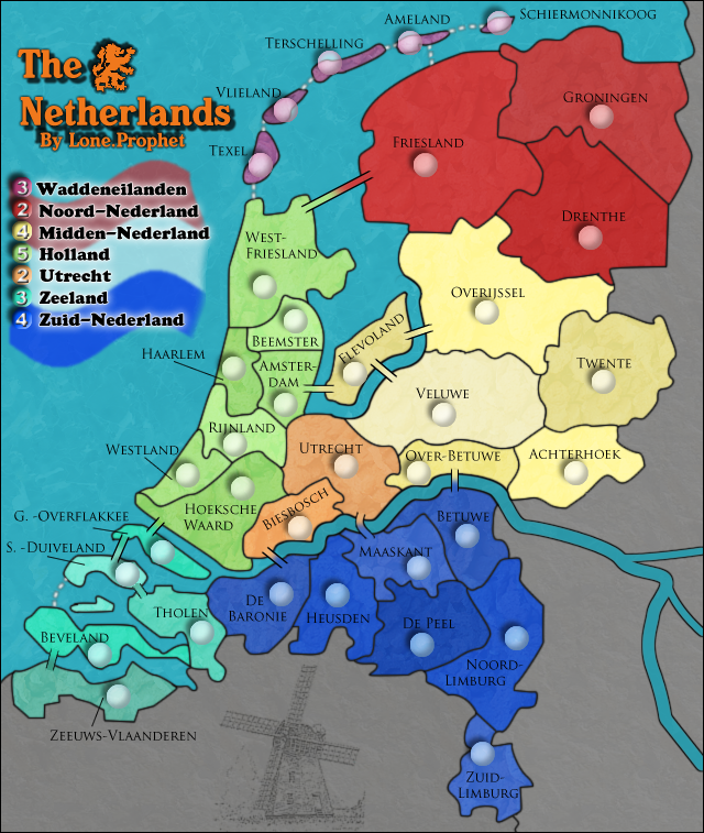
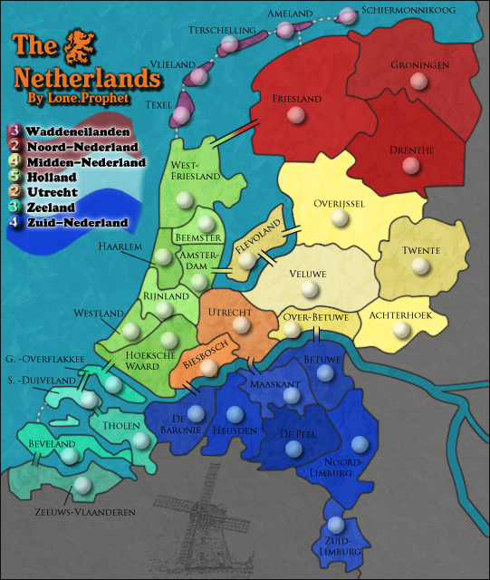
The neutral color is going to change soon to a darker gray, so it should be fine. To worry about the white player might be worth while though. (Yes, there will be a white player.)rebelman wrote:one final clashing colours issue - i think it should be ok but could you post a neutral 88 on all terrs. should be fine but needs a look.
pepperonibread wrote:Sorry, I have to whine some more: On the large map, the shadows of the army circles are going in the opposite direction of the bevel. Also on the large map, the bevel and shadow of the numbers on the on the legend are going in the opposite direction in relation to the small map. And in the title the shadows are going in a few different directions. I think there's a global light option on Photoshop that will make all the light go in the same direction. I'm sorry I even had to mention this; I know how bad you want this quenched.
Coleman wrote:Perfect, thank you lone. Could we see text links to those images and the xml?
lanyards wrote:When comparing the legend on your large and small map, I found that the circles with the value of the the continent bonus have a different shadow angle. On the large map, the shadow is on the north-west side on the circle, and on the small it is on the south-east side.
Code: Select all
 <?xml version="1.0" ?>
- <map>
  <title>The Netherlands</title>
  <smallwidth>541</smallwidth>
  <smallheight>640</smallheight>
  <largewidth>640</largewidth>
  <largeheight>757</largeheight>
  <filetype>png</filetype>
- <continent>
  <name>Wadden Eilanden</name>
  <bonus>3</bonus>
- <components>
  <component>Texel</component>
  <component>Vlieland</component>
  <component>Terschelling</component>
  <component>Ameland</component>
  <component>Schiermonnikoog</component>
  </components>
  </continent>
- <continent>
  <name>Noord Nederland</name>
  <bonus>2</bonus>
- <components>
  <component>Friesland</component>
  <component>Groningen</component>
  <component>Drenthe</component>
  </components>
  </continent>
- <continent>
  <name>Midden Nederland</name>
  <bonus>4</bonus>
- <components>
  <component>Flevoland</component>
  <component>Overijsel</component>
  <component>Twente</component>
  <component>Veluwe</component>
  <component>Over Betuwe</component>
  <component>Achterhoek</component>
  </components>
  </continent>
- <continent>
  <name>Holland</name>
  <bonus>5</bonus>
- <components>
  <component>West Friesland</component>
  <component>Beemster</component>
  <component>Haarlem</component>
  <component>Amsterdam</component>
  <component>Rijnland</component>
  <component>Hoekse Waard</component>
  <component>Westland</component>
  </components>
  </continent>
- <continent>
  <name>Utrecht</name>
  <bonus>2</bonus>
- <components>
  <component>Utrecht</component>
  <component>Biesbosch</component>
  </components>
  </continent>
- <continent>
  <name>Zeeland</name>
  <bonus>3</bonus>
- <components>
  <component>S. Duiveland</component>
  <component>G. Overflakkee</component>
  <component>Tholen</component>
  <component>Beveland</component>
  <component>Zeeuws Vlaanderen</component>
  </components>
  </continent>
- <continent>
  <name>Zuid Nederland</name>
  <bonus>4</bonus>
- <components>
  <component>Zuid-Limburg</component>
  <component>Noord-Limburg</component>
  <component>Betuwe</component>
  <component>De Peel</component>
  <component>Maaskant</component>
  <component>Heusden</component>
  <component>De Baronie</component>
  </components>
  </continent>
- <territory>
  <name>Schiermonnikoog</name>
- <borders>
  <border>Ameland</border>
  </borders>
- <coordinates>
  <smallx>380</smallx>
  <smally>40</smally>
  <largex>450</largex>
  <largey>43</largey>
  </coordinates>
  </territory>
- <territory>
  <name>Ameland</name>
- <borders>
  <border>Friesland</border>
  <border>Terschelling</border>
  <border>Schiermonnikoog</border>
  </borders>
- <coordinates>
  <smallx>311</smallx>
  <smally>55</smally>
  <largex>369</largex>
  <largey>61</largey>
  </coordinates>
  </territory>
- <territory>
  <name>Terschelling</name>
- <borders>
  <border>Ameland</border>
  <border>Vlieland</border>
  </borders>
- <coordinates>
  <smallx>250</smallx>
  <smally>71</smally>
  <largex>297</largex>
  <largey>80</largey>
  </coordinates>
  </territory>
- <territory>
  <name>Vlieland</name>
- <borders>
  <border>Terschelling</border>
  <border>Texel</border>
  </borders>
- <coordinates>
  <smallx>216</smallx>
  <smally>107</smally>
  <largex>256</largex>
  <largey>122</largey>
  </coordinates>
  </territory>
- <territory>
  <name>Texel</name>
- <borders>
  <border>Vlieland</border>
  <border>West Friesland</border>
  </borders>
- <coordinates>
  <smallx>196</smallx>
  <smally>148</smally>
  <largex>233</largex>
  <largey>171</largey>
  </coordinates>
  </territory>
- <territory>
  <name>Friesland</name>
- <borders>
  <border>Ameland</border>
  <border>West Friesland</border>
  <border>Groningen</border>
  <border>Drenthe</border>
  <border>Overijsel</border>
  </borders>
- <coordinates>
  <smallx>323</smallx>
  <smally>149</smally>
  <largex>383</largex>
  <largey>172</largey>
  </coordinates>
  </territory>
- <territory>
  <name>Groningen</name>
- <borders>
  <border>Friesland</border>
  <border>Drenthe</border>
  </borders>
- <coordinates>
  <smallx>458</smallx>
  <smally>112</smally>
  <largex>543</largex>
  <largey>128</largey>
  </coordinates>
  </territory>
- <territory>
  <name>Drenthe</name>
- <borders>
  <border>Friesland</border>
  <border>Groningen</border>
  <border>Overijsel</border>
  </borders>
- <coordinates>
  <smallx>450</smallx>
  <smally>205</smally>
  <largex>533</largex>
  <largey>238</largey>
  </coordinates>
  </territory>
- <territory>
  <name>Overijsel</name>
- <borders>
  <border>Friesland</border>
  <border>Drenthe</border>
  <border>Flevoland</border>
  <border>Veluwe</border>
  <border>Twente</border>
  </borders>
- <coordinates>
  <smallx>371</smallx>
  <smally>262</smally>
  <largex>440</largex>
  <largey>306</largey>
  </coordinates>
  </territory>
- <territory>
  <name>Twente</name>
- <borders>
  <border>Overijsel</border>
  <border>Veluwe</border>
  <border>Achterhoek</border>
  </borders>
- <coordinates>
  <smallx>460</smallx>
  <smally>315</smally>
  <largex>545</largex>
  <largey>369</largey>
  </coordinates>
  </territory>
- <territory>
  <name>Achterhoek</name>
- <borders>
  <border>Twente</border>
  <border>Over Betuwe</border>
  <border>Veluwe</border>
  </borders>
- <coordinates>
  <smallx>440</smallx>
  <smally>386</smally>
  <largex>521</largex>
  <largey>452</largey>
  </coordinates>
  </territory>
- <territory>
  <name>Veluwe</name>
- <borders>
  <border>Overijsel</border>
  <border>Twente</border>
  <border>Achterhoek</border>
  <border>Flevoland</border>
  <border>Over Betuwe</border>
  <border>Utrecht</border>
  </borders>
- <coordinates>
  <smallx>338</smallx>
  <smally>342</smally>
  <largex>400</largex>
  <largey>400</largey>
  </coordinates>
  </territory>
- <territory>
  <name>Over Betuwe</name>
- <borders>
  <border>Betuwe</border>
  <border>Veluwe</border>
  <border>Achterhoek</border>
  <border>Utrecht</border>
  </borders>
- <coordinates>
  <smallx>318</smallx>
  <smally>386</smally>
  <largex>377</largex>
  <largey>453</largey>
  </coordinates>
  </territory>
- <territory>
  <name>Flevoland</name>
- <borders>
  <border>Overijsel</border>
  <border>Amsterdam</border>
  <border>Veluwe</border>
  </borders>
- <coordinates>
  <smallx>269</smallx>
  <smally>309</smally>
  <largex>319</largex>
  <largey>362</largey>
  </coordinates>
  </territory>
- <territory>
  <name>West Friesland</name>
- <borders>
  <border>Friesland</border>
  <border>Texel</border>
  <border>Beemster</border>
  <border>Haarlem</border>
  </borders>
- <coordinates>
  <smallx>200</smallx>
  <smally>243</smally>
  <largex>237</largex>
  <largey>283</largey>
  </coordinates>
  </territory>
- <territory>
  <name>Beemster</name>
- <borders>
  <border>West Friesland</border>
  <border>Haarlem</border>
  <border>Amsterdam</border>
  </borders>
- <coordinates>
  <smallx>224</smallx>
  <smally>269</smally>
  <largex>266</largex>
  <largey>314</largey>
  </coordinates>
  </territory>
- <territory>
  <name>Haarlem</name>
- <borders>
  <border>Amsterdam</border>
  <border>Beemster</border>
  <border>West Friesland</border>
  <border>Rijnland</border>
  </borders>
- <coordinates>
  <smallx>176</smallx>
  <smally>305</smally>
  <largex>209</largex>
  <largey>357</largey>
  </coordinates>
  </territory>
- <territory>
  <name>Amsterdam</name>
- <borders>
  <border>Beemster</border>
  <border>Haarlem</border>
  <border>Rijnland</border>
  <border>Utrecht</border>
  <border>Flevoland</border>
  </borders>
- <coordinates>
  <smallx>216</smallx>
  <smally>333</smally>
  <largex>256</largex>
  <largey>390</largey>
  </coordinates>
  </territory>
- <territory>
  <name>Rijnland</name>
- <borders>
  <border>Haarlem</border>
  <border>Amsterdam</border>
  <border>Utrecht</border>
  <border>Westland</border>
  <border>Hoekse Waard</border>
  </borders>
- <coordinates>
  <smallx>178</smallx>
  <smally>364</smally>
  <largex>211</largex>
  <largey>426</largey>
  </coordinates>
  </territory>
- <territory>
  <name>Westland</name>
- <borders>
  <border>Rijnland</border>
  <border>Hoekse Waard</border>
  </borders>
- <coordinates>
  <smallx>141</smallx>
  <smally>387</smally>
  <largex>167</largex>
  <largey>454</largey>
  </coordinates>
  </territory>
- <territory>
  <name>Hoekse Waard</name>
- <borders>
  <border>Westland</border>
  <border>Utrecht</border>
  <border>Biesbosch</border>
  <border>G. Overflakkee</border>
  <border>Rijnland</border>
  </borders>
- <coordinates>
  <smallx>184</smallx>
  <smally>397</smally>
  <largex>218</largex>
  <largey>466</largey>
  </coordinates>
  </territory>
- <territory>
  <name>Utrecht</name>
- <borders>
  <border>Amsterdam</border>
  <border>Rijnland</border>
  <border>Hoekse Waard</border>
  <border>Over Betuwe</border>
  <border>Biesbosch</border>
  <border>Maaskant</border>
  <border>Veluwe</border>
  </borders>
- <coordinates>
  <smallx>262</smallx>
  <smally>380</smally>
  <largex>311</largex>
  <largey>446</largey>
  </coordinates>
  </territory>
- <territory>
  <name>Biesbosch</name>
- <borders>
  <border>Utrecht</border>
  <border>Hoekse Waard</border>
  <border>De Baronie</border>
  </borders>
- <coordinates>
  <smallx>227</smallx>
  <smally>428</smally>
  <largex>269</largex>
  <largey>502</largey>
  </coordinates>
  </territory>
- <territory>
  <name>G. Overflakkee</name>
- <borders>
  <border>Hoekse Waard</border>
  <border>S. Duiveland</border>
  </borders>
- <coordinates>
  <smallx>121</smallx>
  <smally>447</smally>
  <largex>144</largex>
  <largey>525</largey>
  </coordinates>
  </territory>
- <territory>
  <name>S. Duiveland</name>
- <borders>
  <border>G. Overflakkee</border>
  <border>Tholen</border>
  <border>Beveland</border>
  </borders>
- <coordinates>
  <smallx>94</smallx>
  <smally>464</smally>
  <largex>112</largex>
  <largey>545</largey>
  </coordinates>
  </territory>
- <territory>
  <name>Beveland</name>
- <borders>
  <border>S. Duiveland</border>
  <border>Zeeuws Vlaanderen</border>
  <border>Tholen</border>
  </borders>
- <coordinates>
  <smallx>73</smallx>
  <smally>526</smally>
  <largex>87</largex>
  <largey>618</largey>
  </coordinates>
  </territory>
- <territory>
  <name>Zeeuws Vlaanderen</name>
- <borders>
  <border>Beveland</border>
  </borders>
- <coordinates>
  <smallx>87</smallx>
  <smally>557</smally>
  <largex>104</largex>
  <largey>655</largey>
  </coordinates>
  </territory>
- <territory>
  <name>Tholen</name>
- <borders>
  <border>S. Duiveland</border>
  <border>Beveland</border>
  <border>De Baronie</border>
  </borders>
- <coordinates>
  <smallx>152</smallx>
  <smally>508</smally>
  <largex>180</largex>
  <largey>597</largey>
  </coordinates>
  </territory>
- <territory>
  <name>De Baronie</name>
- <borders>
  <border>Tholen</border>
  <border>Biesbosch</border>
  <border>Heusden</border>
  </borders>
- <coordinates>
  <smallx>212</smallx>
  <smally>479</smally>
  <largex>252</largex>
  <largey>562</largey>
  </coordinates>
  </territory>
- <territory>
  <name>Heusden</name>
- <borders>
  <border>De Baronie</border>
  <border>Maaskant</border>
  <border>De Peel</border>
  </borders>
- <coordinates>
  <smallx>256</smallx>
  <smally>479</smally>
  <largex>303</largex>
  <largey>563</largey>
  </coordinates>
  </territory>
- <territory>
  <name>Maaskant</name>
- <borders>
  <border>Utrecht</border>
  <border>Heusden</border>
  <border>De Peel</border>
  <border>Betuwe</border>
  </borders>
- <coordinates>
  <smallx>319</smallx>
  <smally>458</smally>
  <largex>378</largex>
  <largey>538</largey>
  </coordinates>
  </territory>
- <territory>
  <name>Betuwe</name>
- <borders>
  <border>Noord-Limburg</border>
  <border>Maaskant</border>
  <border>De Peel</border>
  <border>Over Betuwe</border>
  </borders>
- <coordinates>
  <smallx>356</smallx>
  <smally>434</smally>
  <largex>422</largex>
  <largey>509</largey>
  </coordinates>
  </territory>
- <territory>
  <name>De Peel</name>
- <borders>
  <border>Noord-Limburg</border>
  <border>Maaskant</border>
  <border>Heusden</border>
  <border>Betuwe</border>
  </borders>
- <coordinates>
  <smallx>321</smallx>
  <smally>517</smally>
  <largex>380</largex>
  <largey>608</largey>
  </coordinates>
  </territory>
- <territory>
  <name>Noord-Limburg</name>
- <borders>
  <border>De Peel</border>
  <border>Betuwe</border>
  <border>Zuid-Limburg</border>
  </borders>
- <coordinates>
  <smallx>394</smallx>
  <smally>512</smally>
  <largex>467</largex>
  <largey>601</largey>
  </coordinates>
  </territory>
- <territory>
  <name>Zuid-Limburg</name>
- <borders>
  <border>Noord-Limburg</border>
  </borders>
- <coordinates>
  <smallx>367</smallx>
  <smally>601</smally>
  <largex>435</largex>
  <largey>707</largey>
  </coordinates>
  </territory>
</map>Code: Select all
http://i150.photobucket.com/albums/s113/prophetlone/NLfinalcopy-5.pngCode: Select all
http://i150.photobucket.com/albums/s113/prophetlone/NLfinalsmallcopy-4.png
Lone.prophet wrote:NO
Lone.prophet wrote::p lol laynard is working on the XML
gimil wrote:lanyards wrote:When comparing the legend on your large and small map, I found that the circles with the value of the the continent bonus have a different shadow angle. On the large map, the shadow is on the north-west side on the circle, and on the small it is on the south-east side.
small/large consistancy isnt an issues on such trivial issues
yeti_c wrote:gimil wrote:lanyards wrote:When comparing the legend on your large and small map, I found that the circles with the value of the the continent bonus have a different shadow angle. On the large map, the shadow is on the north-west side on the circle, and on the small it is on the south-east side.
small/large consistancy isnt an issues on such trivial issues
Really?!
They do look completely different - the Light source has been completely flipped for both Army circles and Bonus Circles...
C.