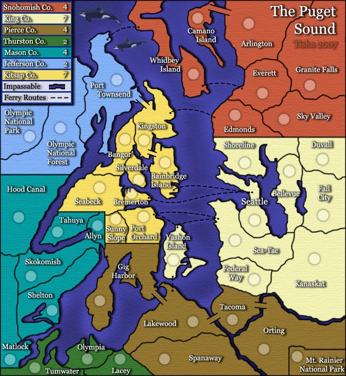
A bigger concern for me is that many of the borders don't match the meeting of the land/water. The edge of Shelton sticks out under the border, as does Tahuya, Gig Harbor, Lakewood, Seattle, Port Townsend... well, most of the shorelines really. This may or may not be an easy fix depending on how the borders were drawn to begin with, but if it were my map I'd want to get it right.
i'm a little confused on what you mean by this, but everything you said was right on topic and very helpful. thanks!
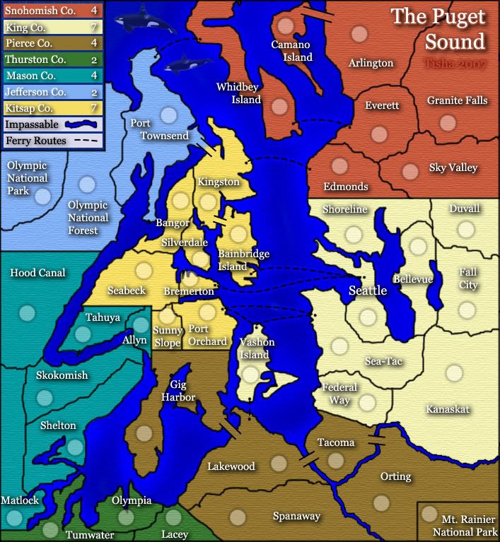
The Puget Sound [Quenched]
Moderator: Cartographers
Forum rules
Please read the Community Guidelines before posting.
Please read the Community Guidelines before posting.
-
Risky_Stud

- Posts: 297
- Joined: Sun Dec 24, 2006 12:04 am
- Gender: Male
- Location: Recliner Surfing in my living room

oaktown wrote:The Mt Rainier border is so square it looks like legend info... I seem to recall this being discussed earlier so if this is old news you can tell me where to stick it.
It is square, because in reality...it is square.

The Pro-Tip®, SkyDaddy® and
 are registered trademarks of Backglass Heavy Industries.
Re: border problems.
What I mean is that the black line that serves as the border between a region and the water should actually be between the region and the water. In many places they are not. Note all of the little bits of color sticking out past the border into the water; it's not something you notice right away, but once you are aware of them it is very annoying...
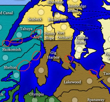
If it were my map it would mean tweaking the paths of the borders just a bit and re-stroking them, but I don't know how this file was set up. Easiest fix may be following all of the borders and just deleting any pixels of color that have no business being in the water.
Risky_Stud wrote:i'm a little confused on what you mean by this, but everything you said was right on topic and very helpful. thanks!
What I mean is that the black line that serves as the border between a region and the water should actually be between the region and the water. In many places they are not. Note all of the little bits of color sticking out past the border into the water; it's not something you notice right away, but once you are aware of them it is very annoying...
If it were my map it would mean tweaking the paths of the borders just a bit and re-stroking them, but I don't know how this file was set up. Easiest fix may be following all of the borders and just deleting any pixels of color that have no business being in the water.

Backglass wrote:oaktown wrote:The Mt Rainier border is so square it looks like legend info... I seem to recall this being discussed earlier so if this is old news you can tell me where to stick it.
It is square, because in reality...it is square.
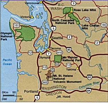
Sure it is... as seen from space! The North West corner of the actual park is not at right angles.


yeti_c wrote:Wow - Mibi what else did you do - for me that really makes the map - the slight drop in tone makes the colours so much nicer - and they blend better for it...
C.
uh... I added an inner bevel to the water with the following settings,
Inner bevel
Chisel soft
Depth:31
Direction: down
size: 6
soften: 8
adn an Inner shadow with the following
opacity: 75 although in retrospect, this should be lower
angle: 120
distance 5
cholse 0
size 5
I thought the water needed some depth or something.
-
rebelman

- Posts: 2968
- Joined: Thu Aug 02, 2007 5:24 pm
- Gender: Male
- Location: People's Republic of Cork
- Contact:
yeti_c wrote:Wow - Mibi what else did you do - for me that really makes the map - the slight drop in tone makes the colours so much nicer - and they blend better for it...
C.
i agree, nice work mibi it makes a big difference
Don't now why people on here don't like being cooks, remember under siege: A former SEAL, now cook, is the only person who can stop a gang of terrorists when they sieze control of a US Navy battleship.
oaktown wrote:Backglass wrote:oaktown wrote:The Mt Rainier border is so square it looks like legend info... I seem to recall this being discussed earlier so if this is old news you can tell me where to stick it.
It is square, because in reality...it is square.
Sure it is... as seen from space!
...and where are all the CC maps seen from. A very tall ladder?
I like it. QUENCH! QUENCH! QUENCH!
The Pro-Tip®, SkyDaddy® and
are registered trademarks of Backglass Heavy Industries.Backglass wrote:I like it. QUENCH! QUENCH! QUENCH!
Thank you for the thoughtful feedback Backglass. Constructive posts like this will definitely get this quenched faster.
Mibi's suggestion is a good one - the lighter color is more in keeping witht he map, and it's very Seattle Seahawks. The bevel should be brought down a notch, as it should look like the land is casting a shadow and not like the land is floating above the water. The inner shadow is indeed a bit too much, and there probably shouldn't be shadow around the attack routes.
Can I ask why the light source is north-west of the map? When would the sun be north of Seattle?
yeti_c wrote:oaktown wrote:Can I ask why the light source is north-west of the map? When would the sun be north of Seattle?
Do they get 24 hour days in Seattle?
If so - then the middle of the night.
C.
No 24 hour days... it's a similar latitude to London I believe, so probably about eight hours of daylight in December. (??) But I guess at sunset the sun would appear north on the horizon, so I'll leave it alone... this was just a nitpicky thing anyway.
oaktown wrote:Backglass wrote:I like it. QUENCH! QUENCH! QUENCH!
Thank you for the thoughtful feedback Backglass. Constructive posts like this will definitely get this quenched faster.
Mibi's suggestion is a good one - the lighter color is more in keeping witht he map, and it's very Seattle Seahawks. The bevel should be brought down a notch, as it should look like the land is casting a shadow and not like the land is floating above the water. The inner shadow is indeed a bit too much, and there probably shouldn't be shadow around the attack routes.
Can I ask why the light source is north-west of the map? When would the sun be north of Seattle?
its not my map bro, i just made some 30 second changes


oaktown wrote:Thank you for the thoughtful feedback Backglass. Constructive posts like this will definitely get this quenched faster.
Much like your "space view" analogy?
Seriously you guys, you are quibbling over minuscule things. This isn't the Mona Lisa or a masterpiece like Doodle Earth.
It's a fine map. Let it go.
The Pro-Tip®, SkyDaddy® and
are registered trademarks of Backglass Heavy Industries.-
cena-rules

- Posts: 9740
- Joined: Sat Apr 28, 2007 2:27 am
- Gender: Male
- Location: Chat
oaktown wrote:
Anyway, I've never seen a map thread in which I get criticixed for trying to be positive and constructive. You need to try to take control of this situation,Tisha, or else your going to lose your feedback and this map will sit in the Forge for months.
well you can help her by not responding
an eye for an eye makes the whole world blind
ON TOPIC
Tisha this is a lovely map that just needs some minor touching uo. Keeep your chin up and facing that PC. You will do it.
19:41:22 ‹jakewilliams› I was a pedo
Tisha wrote:lol.. i need to take control? i have no control over what someone types...the only time i have see backglass is in my map thread
Wow, fast response - you beat my edit re. light source (above)!
You're right of course. And it's nice to have the support of users who want to see this completed. I've got them in my thread, and I usually tell them not to jinx the process.
This thread was already taken off-track once, I just hope it doesn't happen again. I promise to stop responding to inane comments and restrict my input to map-related details.
The borders you'd showed me earlier looked better - the pixelation was much reduced, and I actually thought the border thickness was good. Reworking the color of the water might take care of some of the problems you were still seeing with the borders, as I think the water's inner glow was not consistent and it was making the borders look different.
<Snip!>
I think it's a fine map and Tisha you have done a commendable job. I for one would like to see more of your work in the future.
I think it's a fine map and Tisha you have done a commendable job. I for one would like to see more of your work in the future.
Last edited by Backglass on Wed Nov 21, 2007 2:31 pm, edited 2 times in total.
The Pro-Tip®, SkyDaddy® and
are registered trademarks of Backglass Heavy Industries.-
cena-rules
- Posts: 9740
- Joined: Sat Apr 28, 2007 2:27 am
- Gender: Male
- Location: Chat
Tisha wrote:the only time i have see backglass is in my map thread
Well, you will see much more of me now...you have a fan.
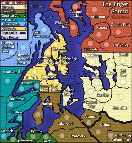
Tisha wrote:i had really thought that mt. rainier was squared..it was on the map i was looking at.. i'm redoing borders anyway..i have no problem changing it
Please do, so that this issue can die.
So...what else remains?
The Pro-Tip®, SkyDaddy® and
are registered trademarks of Backglass Heavy Industries.redrew all the borders...even the mt. rainier area. after i redid the borders i went all around and made sure color wasn't hanging out on the wrong side of the border anywhere
redid the drop shadow on all names
straightened the ferry routes in the legend
tried to center words and numbers better in the legend
desaturated the water a bit
i added a bit of a drop shadow to the land..but i don't like the way that it adds shadow to my rivers also
redid the drop shadow on all names
straightened the ferry routes in the legend
tried to center words and numbers better in the legend
desaturated the water a bit
i added a bit of a drop shadow to the land..but i don't like the way that it adds shadow to my rivers also