Crossword map [Done]

Care to peruse completed maps? Take a stroll through the Atlas.

Moderator: Cartographers

Forum rules
Please read the Community Guidelines before posting.
User avatar
Jota
Posts: 634
Joined: Wed Mar 29, 2006 7:38 pm

Crossword map [Done]

Post by Jota »

After reading a couple of threads that mentioned maps that weren't strictly geographical, I came up with the idea for this one:

Image

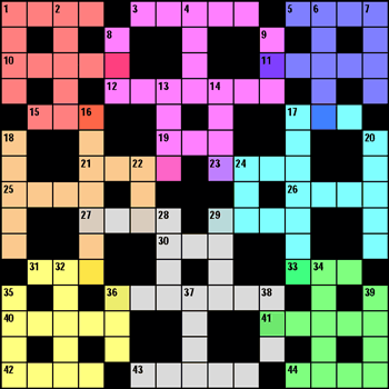
Each word is a country, and the intersections are the borders between them. There are eight color-coded continents. Tentatively, I'm assigning bonus armies as red: 3, purple: 4, blue: 2, orange: 3, cyan: 4, yellow: 3, silver: 6, green: 2. The XML I'm working on right now displays the army counts in the unchecked squares.

I tried to design the grid to make sure that most countries and continents had a reasonable number of borders, with some variety. What do people think?
User avatar
kingwaffles
Posts: 718
Joined: Mon Jan 23, 2006 9:05 am
Location: Pseudopolis Yard, Ankh Morpork, Discworld

Post by kingwaffles »

I think it's a really cool idea, I'm all for non conventional maps. I'm having a hard time figuring out the countries, maybe its just me but i think it would help to have each word be a slightly different shade to make them more obvious. I think it has great potential!
Image
Pedronicus
Posts: 2080
Joined: Tue Jan 24, 2006 2:42 pm
Gender: Male
Location: Busy not shitting you....

Post by Pedronicus »

Best idea I've seen so far.

You could spice things up by introducing the scrabble letters with the assigned numbers and we could insert letters as well (include loads of blanks) for an additional bonus of words created
Pedronicus
Posts: 2080
Joined: Tue Jan 24, 2006 2:42 pm
Gender: Male
Location: Busy not shitting you....

Post by Pedronicus »

I also like the way you've incorporated the over lapping continents
Pedronicus
Posts: 2080
Joined: Tue Jan 24, 2006 2:42 pm
Gender: Male
Location: Busy not shitting you....

Post by Pedronicus »

Lack Attack should give you a prize for the most original entry ever seen in this forum.

Originality needs to be rewarded Lack
Pedronicus
Posts: 2080
Joined: Tue Jan 24, 2006 2:42 pm
Gender: Male
Location: Busy not shitting you....

Post by Pedronicus »

AND THIS IS THIS GUYS FIRST POST.
User avatar
Jota
Posts: 634
Joined: Wed Mar 29, 2006 7:38 pm

Post by Jota »

kingwaffles wrote:I'm having a hard time figuring out the countries, maybe its just me but i think it would help to have each word be a slightly different shade to make them more obvious.


The countries are things like "9-Down" and "25-Across". 25-Across shares letters with 18-Down and 16-Down, so it borders on those two countries (and all three of them are part of the Orange continent). Since the borders are the squares that are part of both words, I think it would be difficult to shade two bordering countries differently without making it more confusing. But I might give it a shot if it seems it would be helpful.

I've put the large version up at http://grunk.org/risk/risk-xword2-large.gif and the XML at http://grunk.org/risk/xword.xml if anyone wants to play with them.

Also, thanks to both of you for the positive feedback!
User avatar
lackattack
Posts: 6097
Joined: Sun Jan 01, 2006 10:34 pm
Location: Montreal, QC

Post by lackattack »

very cool, very original
User avatar
kingwaffles
Posts: 718
Joined: Mon Jan 23, 2006 9:05 am
Location: Pseudopolis Yard, Ankh Morpork, Discworld

Post by kingwaffles »

Okay, makes more sense now. Very cool idea, very original! Great job dude!
Image
User avatar
john123
Posts: 161
Joined: Mon Feb 20, 2006 10:48 am
Location: Ireland

Post by john123 »

yeah really like it, it looks suprisingly playable, those overlapping continents are a great idea
User avatar
kingwaffles
Posts: 718
Joined: Mon Jan 23, 2006 9:05 am
Location: Pseudopolis Yard, Ankh Morpork, Discworld

Post by kingwaffles »

You know Pedro, you easily could have fit all that in one post...
But I do agree with you 100 percent, its great to have cool new ideas instead of just various parts of the globe. Maybe it's time I did some brainstorming myself for map ideas...
Image
User avatar
Mjolnirs
Posts: 180
Joined: Fri Mar 17, 2006 9:22 am
Location: Charleston, SC
Contact:

Post by Mjolnirs »

Interesting map Jota, so would you read it like:
11 across attacks 9 down?
User avatar
Jota
Posts: 634
Joined: Wed Mar 29, 2006 7:38 pm

Post by Jota »

Exactly like that, Mjolnirs.
User avatar
supermarcol
Posts: 153
Joined: Mon Jan 30, 2006 7:19 pm
Location: Montreal, Qc

Post by supermarcol »

Are those skulls? cause if they are its so cool. And if they aren't, I need to go get myself checked.
-SuperMarcol
User avatar
kingwaffles
Posts: 718
Joined: Mon Jan 23, 2006 9:05 am
Location: Pseudopolis Yard, Ankh Morpork, Discworld

Post by kingwaffles »

Wow, thats awesome, I didn't see that at all.....
Image
User avatar
Jota
Posts: 634
Joined: Wed Mar 29, 2006 7:38 pm

Post by Jota »

The skulls were actually accidental: I didn't even notice them myself until I started coloring in the continents.

When I add the sidebar about bonus armies to the graphic, should I also include a short note explaining the countries and borders?
User avatar
thegrimsleeper
Posts: 984
Joined: Thu Jan 26, 2006 10:40 am
Location: Seattle
Contact:

Post by thegrimsleeper »

Yeah, if you don't the bug Report and Map Foundry forums will be inundated with "WTF posts"...

Great map btw. Where'd you get the idea?
User avatar
Jota
Posts: 634
Joined: Wed Mar 29, 2006 7:38 pm

Post by Jota »

I'm not quite sure. I was thinking about how all the existing maps seemed fairly mundane, and I was wondering what kind of non-standard map I could design without a lot of drawing skill (and without pirating images)... and it just sort of came to me.

Speaking of which, what's the general opinion (or more importantly, lack's opinion) of using images that are available on the Internet, without any explicit "please do not steal our pictures" notice?
User avatar
thegrimsleeper
Posts: 984
Joined: Thu Jan 26, 2006 10:40 am
Location: Seattle
Contact:

Post by thegrimsleeper »

It's fairly easy to get around that. just tweak the image in Photoshop or something. If you've altered the image, it's not their picture anymore, it's something fresh.
User avatar
AndyDufresne
Posts: 24935
Joined: Fri Mar 03, 2006 8:22 pm
Location: A Banana Palm in Zihuatanejo
Contact:

Post by AndyDufresne »

Quite a unique idea, I'd be willing to play a game or two on it, but there's just something I like about taking over "countries" and continents. But it's still an imaginative piece of work, and hopefully it will inspire others to look for more unique visions into the RISK world.

--Andy
User avatar
Marvaddin
Posts: 2545
Joined: Thu Feb 09, 2006 5:06 pm
Location: Belo Horizonte, Brazil

Post by Marvaddin »

It has certain lack of appeal to me... Conquering real countries and continents is better than conquer "25 across" (my opinion). Anyway, it can be playable, but its a bit confusing to know what is really a country. There are isolated squares with a different color... what this mean? What continent / country they belong? Its very strange parts of countries that shuffles with other countries. And where will you put the numbers? Are there 1 across and 1 down?

Im confused. I think its imaginative, but it will not have that much use... its very strange and unusual.
Image
User avatar
Jota
Posts: 634
Joined: Wed Mar 29, 2006 7:38 pm

Post by Jota »

Those squares are the borders between two words that are two different colors. Since each color represents a different continent, that effectively makes them the borders between continents.

For example, 10-Across is part of the Red continent, and it's five letters long. Its last letter is also the middle letter of 8-Down, part of the Purple continent. Because the two words cross, 10-Across and 8-Down border on each other. A player who controls the Red continent can make inroads into Purple by attacking 8-Down from 10-Across.

Just like in a crossword puzzle, 1-Across and 1-Down are two different words (and thus, two different countries). Since they cross each other (in the upper-left square of the grid), they also share a border.
User avatar
lackattack
Posts: 6097
Joined: Sun Jan 01, 2006 10:34 pm
Location: Montreal, QC

Post by lackattack »

This map is now live!
User avatar
Marvaddin
Posts: 2545
Joined: Thu Feb 09, 2006 5:06 pm
Location: Belo Horizonte, Brazil

Post by Marvaddin »

As I said, much more difficult to read than a normal map. :x :x :x
This will surely be the less used map of all Conquer Club :roll:
Image
User avatar
AndyDufresne
Posts: 24935
Joined: Fri Mar 03, 2006 8:22 pm
Location: A Banana Palm in Zihuatanejo
Contact:

Post by AndyDufresne »

I think once maps start to become more unique and develop outside of standard geographic regions, it will hold it's own. ;) And plus, who likes to play that Brazil map? ;) (just kidding).

--Andy
Post Reply

Return to “The Atlas”