Middle America Map {Advanced Draft} ~ NEW UPDATE 2.3!!
Moderator: Cartographers
Forum rules
Please read the Community Guidelines before posting.
Please read the Community Guidelines before posting.

ok, i will try another font... about the islands, i think it will be clear when i add the circles, because each name will have a circle next to it, that should clear things up... about the island connections, i didn't add them cause i thought they were like obvious, but i think it will be better to add them so that there are no confusions

I would like the included area to remain as it is. Southern Arizona and Texas are very immediate to Sonorans and Chihuahuans, even if they're far from the Caribbean Sea, so if you're keeping northern Mexico...and I think it would be weird to lose northern Mexico if you're keeping southern Mexico...and I think it would be weird to, ah, you know where this is going. But having only one coast of Central America would be weird, and I like splitting up the countries that are split up.
I think it's fine as is, but if people are concerned about the title/concept not matching the area, the name could be changed to New Spain, or Columbus' World...I'd have to check up on this, but I'm pretty sure everything from north of Arizona to the bottom of this map and everything in between was once part of New Spain, except maybe Louisiana (New France?) and Georgia (New Poland?).
Again, I don't think it's a problem. This part of the world should just have a map.


Hi Maritovw:
Great job on the map! It's very rare you see such a developed product on the first post. Your work is very impressive.
I just want to comment on three issues with the playability:
1. When using a group of islands as one territory (such as The Bahamas) it can be confusing which islands are part of that territory. The Greece map had the same issue and that mapmaker drew a circle around the Kyklades to help and I find it works very well. You should probably check it out.
2. Make the attack lines between the islands as clear as possible so there is no confusion about which island (or island group) can attack where.
3. Try to avoid the map being played in a circular manner. What I mean is that you should allow attacks from Cuba to the Yucatan, not just have the Inner Antilles connected in a linear manner.
Looking forward to seeing the next version!
-
reverend_kyle

- Posts: 9250
- Joined: Tue Mar 21, 2006 4:08 pm
- Location: 1000 post club
- Contact:
-
Ronaldinho
- Posts: 3069
- Joined: Sat May 27, 2006 5:35 pm
- Gender: Male
- Location: Dorset, England.

i will be posting a new version in a couple of days.. i will post two or three maps with different fonts to compare them.....
about the name, i may call it "The New World" or as rock suggested "New Spain" (or "Nueva España" wich is the same but in spanish)... i'll open a poll to decide on the best name...
about the name, i may call it "The New World" or as rock suggested "New Spain" (or "Nueva España" wich is the same but in spanish)... i'll open a poll to decide on the best name...
-
wcaclimbing

- Posts: 5598
- Joined: Fri May 12, 2006 10:09 pm
- Location: In your quantum box....Maybe.
- Contact:


-
Ronaldinho
- Posts: 3069
- Joined: Sat May 27, 2006 5:35 pm
- Gender: Male
- Location: Dorset, England.
-
happysadfun

- Posts: 1251
- Joined: Mon Jul 10, 2006 9:06 pm
- Location: Haundin at DotSco, Being Sad that Mark Green Lost in Suburban Wisconsin
maritovw wrote:i will be posting a new version in a couple of days..
i'm afraid that won't be possible... this week i will be loaded with tests (calculus & differential equations
nonetheless, keep voting in the poll and commenting... as of now, "The Caribbean Sea", "Nueva España", and "Middle America" are the most popular... personally, i'd prefer "Nueva España", but the people wil decide on this one...
-
happysadfun
- Posts: 1251
- Joined: Mon Jul 10, 2006 9:06 pm
- Location: Haundin at DotSco, Being Sad that Mark Green Lost in Suburban Wisconsin
new spain in either language doesn't work because of arizona and texas, unless the timeframe was set to back before the louisiana purchase, in which case many of the states could be renamed northern mexico. and sorry, marvaddin, i had some history wrong. italians poured into southern brazil (by porto alegre) and northern argentina and uruguay, but did not own it.
 Children, this is what happens to hockey players, druggies, and Hillary Clinton.
Rope. Tree. Hillary. Some assembly required.
-
fluffybunnykins

- Posts: 385
- Joined: Tue May 02, 2006 6:43 am
- Location: Liverpool, UK
I voted Nueva Espana... I like anything a bit different and that enhances or illustrates the flavour of the map.
Hey Maritovw, you really in Guatemala? I lived there for a few months a while back. Learnt spanish there, which is why spanish people look at me funny when I speak to them! That and that I'm still rubbish... pues...
El mapa esta bien realizado, creo que jugara bueno. Felicitaciones!
Hasta Luego
Hey Maritovw, you really in Guatemala? I lived there for a few months a while back. Learnt spanish there, which is why spanish people look at me funny when I speak to them! That and that I'm still rubbish... pues...
El mapa esta bien realizado, creo que jugara bueno. Felicitaciones!
Hasta Luego
Superman wears 'Fluffybunnykins' pyjamas
happysadfun wrote:new spain in either language doesn't work because of arizona and texas, unless the timeframe was set to back before the louisiana purchase, in which case many of the states could be renamed northern mexico.
Before Mexican independence in 1821 - when they became part of Mexico - Arizona and Texas were both part of New Spain.
There are definitely parts of this map that weren't in New Spain, but I think it's close enough for CC purposes...
-
happysadfun
- Posts: 1251
- Joined: Mon Jul 10, 2006 9:06 pm
- Location: Haundin at DotSco, Being Sad that Mark Green Lost in Suburban Wisconsin
well then shouldn't texas and arizona be part of mexico, and possibly florida part of the greater antilles? better yet, wasn't there one half of florida owned by the us (west florida i think) and one part by spain? couldn't that be added? that would work! MUAHAHAHAHAHAHAHAHAHAHAHAHAHAHAHAHAHAHAHAHAHAHAHAHAHAHAHAHAHAHAHAHAHAHAHAHAHAHAHAHAHAHAHAHAHAHAHAHAHAHAHAHAHAHHAHAHAHA! SORRY THE ADHD PILLS DON'T WORK
Children, this is what happens to hockey players, druggies, and Hillary Clinton.
Rope. Tree. Hillary. Some assembly required.
-
Fireside Poet

- Posts: 2671
- Joined: Mon Apr 24, 2006 1:49 pm

the map is located in the area where the spanish once had most of their colonies, so you tell me that some US territories don't belong to the map because they were never spain's.... deleting this territories would be like deleting Africa and the Near East on the Europe map or like deleting Oceania in the Asia map... got my point? this territories didn't belong to spain but they were borders of spain's territories, so they are also important because border conflicts have been common in all america, especially in the 19th century. so, even if they never actually belonged to spain, i think i should leave them there because of their historical importance...
this is exactly what i mean!!!
hey fluffybunnykins: si, yo soy de Guatemala (that explains this post lol)... you almost got right what you wrote, only "que jugara bueno" is wrong, it should be "que se jugara bien" lol... and that "pues" es muy guatemalteco
rocksolid wrote:There are definitely parts of this map that weren't in New Spain, but I think it's close enough for CC purposes...
this is exactly what i mean!!!
hey fluffybunnykins: si, yo soy de Guatemala (that explains this post lol)... you almost got right what you wrote, only "que jugara bueno" is wrong, it should be "que se jugara bien" lol... and that "pues" es muy guatemalteco
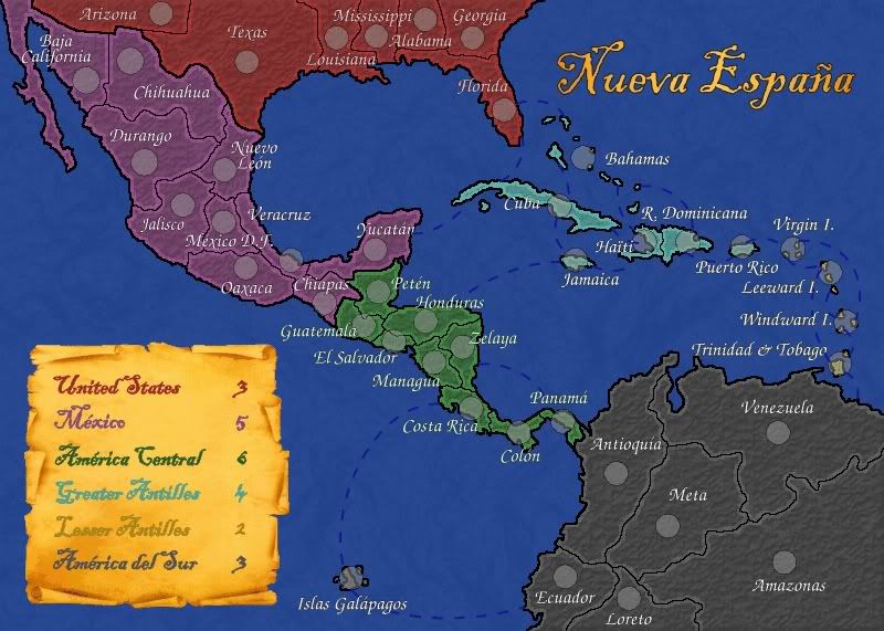
 MIDDLE AMERICA MAP
well, finally i had time to work on this map so here it is!! the last UPDATE.
things updated:
- drew all attack routes
- added the circles
- changed the font
as i had promised, i created several versions of the map, all the same but with different fonts, to choose the best one. here are the maps:
- Font no. 1
- Font no. 2
- Font no. 3
- Font no. 4
- Font no. 5
i'm opening a new poll to vote for the font you like the best. personally, i like no. 5 because it has some style but it still is very readable.
EDIT: i'm not changing the poll so post here to vote
please, i'd appreciate your comments very much!!
about the name poll, below are the results. because no name got at least half the votes, i'll open a "second round" after choosing the font. in this second round only "The Caribbean Sea" and "Nueva España" will be available.
EDIT: already changed. VOTE NOW!!
How should this map be named?
"The Caribbean Sea" 39% [ 16 ]
"The New World" 14% [ 6 ]
"New Spain" 2% [ 1 ]
"Nueva España" (spanish for "New Spain") 29% [ 12 ]
"Middle America" 14% [ 6 ]
Total Votes : 41
Last edited by maritovw on Tue Aug 08, 2006 11:41 pm, edited 1 time in total.
-
gavin_sidhu

- Posts: 1428
- Joined: Mon May 22, 2006 6:16 am
- Location: Brisbane, Australia
aww.. middle america got knocked out, but i guess the majority ruled. If people are complaining about the political corectness, I think you could get away with it if you trim the top of the map so it looks more concentrated and focussed on the spanish part of america even though the number of USA territories remain the same. The Europe map has lots of countries that are not part of europe but it does not look that way because only the very north of african territories is shown. Only problem is then you would be squished for space.
Highest Score: 1843 Ranking (Australians): 3
how about we name it
how about we name it if u want to kill a spanish person look for 1 in 1 of these states
