Canada map: Revealed! [Done]
Moderator: Cartographers
Forum rules
Please read the Community Guidelines before posting.
Please read the Community Guidelines before posting.
-
supermarcol

- Posts: 153
- Joined: Mon Jan 30, 2006 7:19 pm
- Location: Montreal, Qc
Hmmm I don't know. One thing I know is that I can't please everyone with this map. So if other people think its a problem then I'll go through the process of change the colors. But personally I like it this way, I find it has a "plastic" look. And I don't understand the people who say every province should have its regions in the same color, I mean its pretty obvious that they follow the same color scheme. Unless you are color blind you shouldn't have problem differenciating shades of red and shades of blue... But anyway, midterm tomorow so no updates tonight 
-SuperMarcol
-
supermarcol
- Posts: 153
- Joined: Mon Jan 30, 2006 7:19 pm
- Location: Montreal, Qc

-
kingwaffles

- Posts: 718
- Joined: Mon Jan 23, 2006 9:05 am
- Location: Pseudopolis Yard, Ankh Morpork, Discworld
-
dagreatbroomhead

- Posts: 453
- Joined: Sun Jan 22, 2006 5:02 pm
- Location: Maine
-
supermarcol
- Posts: 153
- Joined: Mon Jan 30, 2006 7:19 pm
- Location: Montreal, Qc
-
supermarcol
- Posts: 153
- Joined: Mon Jan 30, 2006 7:19 pm
- Location: Montreal, Qc
Ok, if someone has a lot of time on their hand and don't know what to do, can you check through my xml and see if I did any mistakes? I don't expect anyone to do it, and I will do it a fourth time for sure before I submit it, but if you want to it would be great. The 2 things to watch for are missing countries and misspelled (or is it misspellt?) countries.
Heres the xml:
http://www.geocities.com/supermarcol/prog.txt
heres a copy of the map to look at:
http://i45.photobucket.com/albums/f80/supermarcol/testlarge.png
It will be out there soon!
Heres the xml:
http://www.geocities.com/supermarcol/prog.txt
heres a copy of the map to look at:
http://i45.photobucket.com/albums/f80/supermarcol/testlarge.png
It will be out there soon!
-SuperMarcol
-
thegrimsleeper

- Posts: 984
- Joined: Thu Jan 26, 2006 10:40 am
- Location: Seattle
- Contact:
According to the XML...
1. Nova Scotia can attack New Brunswick, but not the other way around.
2. Kenora can attack Thompson, but not the other way around.
If there are any other errors in the borders, I'll eat my hat.
I would like to point out that I was only keeping my eyes peeled for the most glaring of spelling errors (or countries whose names had been misspellED), so unless someone else who's got 15 to spare wants to go through and quadruple-check things, I'd say this one's good.
Now if only I could motivate myself to finish the damn small version of the Europe map...
-
supermarcol
- Posts: 153
- Joined: Mon Jan 30, 2006 7:19 pm
- Location: Montreal, Qc

-
supermarcol
- Posts: 153
- Joined: Mon Jan 30, 2006 7:19 pm
- Location: Montreal, Qc
-
amandahugandkiss
- Posts: 39
- Joined: Sun Feb 19, 2006 11:59 am
program
WhaT program did you use???
I'm taking your advice and working on an NYC map, but what should I use instead of paint, is it possible for me to hand draw the map then scan??? I can draw, I'm just not familiar with computer graphics programs
I'm taking your advice and working on an NYC map, but what should I use instead of paint, is it possible for me to hand draw the map then scan??? I can draw, I'm just not familiar with computer graphics programs
-
supermarcol
- Posts: 153
- Joined: Mon Jan 30, 2006 7:19 pm
- Location: Montreal, Qc
You could probably do this, but it would be hard to edit the map afterwards. One of my advantage is that I used one of these computer pen, so it was easier to draw the map. As for what program I used, I used flash... not a very good choice, I just happen to know how it works. What you want for a good mapmaking graphic editor is the ability to work with layers. You can do that in photoshop, its just that photoshop is hard to learn (i should have done my map in photoshop, but i was too lazy to learn it hah). It is possible to make your map in paint, but it would also be hard, and unless you spend a lot of time on it it wouldn't look very professional. My suggestion is the following: get yourself some  illegal copy of photoshop, google for a basic tutorial or check if one is included and you should be able to start your map. I think that what is the most important is to get a sketch version up as soon as possible. When you actually post a map, however ugly or basic it is, you can start to receive advice from other users, and this will make your time much, much easier. But start by learning the basics of photoshop or another program like that, and then play around a bit with sketching your map.
-SuperMarcol
-
thegrimsleeper
- Posts: 984
- Joined: Thu Jan 26, 2006 10:40 am
- Location: Seattle
- Contact:
Funny, I always found Photoshop to be fairly intuitive...
You really don't need to free-hand anything. I recommend just googling a map, then editing in Photoshop. Drawing with a mouse can be hard, but tracing is another story. Make sure you do this in a seperate layer from the background, so editing will be easier later.
You probably don't even need a full copy of Photoshop. I'm sure you can find a free trial on the internet somewhere. Another great program is JASC Paint Shop Pro.
-
supermarcol
- Posts: 153
- Joined: Mon Jan 30, 2006 7:19 pm
- Location: Montreal, Qc

-
cdnfireman

- Posts: 78
- Joined: Thu May 31, 2007 8:44 pm
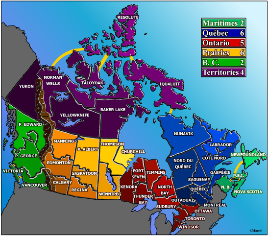
Mistake in Canada map.
Not being picky or anything, but I'm in my first Canada map game, game #971591 Well I live in northern Ontario, small town near Sudbury and I know the area well. The mistake is Sudbury area and North Bay area are backwards.
Just wanted to mention it.
Just wanted to mention it.


-
BigKofJustice
- Posts: 1
- Joined: Thu Jan 29, 2009 1:24 pm
- Location: Los Angeles, CA
Re: Canada map: Revealed! [Done]
An observation from an ex-pat Newfie,
I notice the map is divided up along provincial lines and this subdivided into different regions. That being said, why would Labrador be included with Quebec, as it's part of Newfoundland & Labrador and is considered a Maritime province.
From a game play / balance perspective you could treat Newfoundland & Labrador as one region as it is in reality.
Of course this is a game...
-
WidowMakers
- Posts: 2774
- Joined: Mon Nov 20, 2006 9:25 am
- Gender: Male
- Location: Detroit, MI
Re: Canada map: Revealed! [Done]
You 15 month bumped the thread to the old map before the revamp. WOW

-
BaldAdonis

- Posts: 2334
- Joined: Fri Aug 24, 2007 1:57 am
- Location: Trapped in Pleasantville with Toby McGuire
Re: Canada map: Revealed! [Done]
WidowMakers wrote:You 15 month bumped the thread to the old map before the revamp. WOW
Even with the revamp, Labrador is still part of Quebec.
-
WidowMakers
- Posts: 2774
- Joined: Mon Nov 20, 2006 9:25 am
- Gender: Male
- Location: Detroit, MI
Re: Canada map: Revealed! [Done]
Because revamps can't change game playBaldAdonis wrote:WidowMakers wrote:You 15 month bumped the thread to the old map before the revamp. WOW
Even with the revamp, Labrador is still part of Quebec.

Re: Canada map: Revealed! [Done]
WidowMakers wrote:Because revamps can't change game playBaldAdonis wrote:WidowMakers wrote:You 15 month bumped the thread to the old map before the revamp. WOW
Even with the revamp, Labrador is still part of Quebec.
Unless the original cartographer says it's ok.

-
WidowMakers
- Posts: 2774
- Joined: Mon Nov 20, 2006 9:25 am
- Gender: Male
- Location: Detroit, MI
Re: Canada map: Revealed! [Done]
I really don't even know if it is OK then. Because people are already used to the map and new GP messes that up.Gilligan wrote:WidowMakers wrote:Because revamps can't change game playBaldAdonis wrote:WidowMakers wrote:You 15 month bumped the thread to the old map before the revamp. WOW
Even with the revamp, Labrador is still part of Quebec.
Unless the original cartographer says it's ok.

Re: Canada map: Revealed! [Done]
I don't mean to be nit-picking, but the Maritimes are the provinces of NB, NS & PEI. When Newfoundland is included withe the Maritime Provinces, the correct name is The Atlantic Provinces
Love the map and have had pretty good luck with it.
Love the map and have had pretty good luck with it.