I don't know why this has completely slipped my mind. I like these sort of things. I think the problem is I don't know what they're looking for/ investigating now.
AoG for President of the World!! I promise he will put George W. Bush to shame!
Gillipig wrote:I don't know why this has completely slipped my mind. I like these sort of things. I think the problem is I don't know what they're looking for/ investigating now.
Space exploration is just mans never ending qwest to see new and previously unknown to them boob. It drives everything mankind does.
IcePack
fac vitam incredibilem memento vivere Knowledge Weighs Nothing, Carry All You Can
Gillipig wrote:I don't know why this has completely slipped my mind. I like these sort of things. I think the problem is I don't know what they're looking for/ investigating now.
Space exploration is just mans never ending qwest to see new and previously unknown to them boob. It drives everything mankind does.
IcePack
Not talking generally here but speficically. Also I don't know if I agree with that theory lol.
AoG for President of the World!! I promise he will put George W. Bush to shame!
Check out this video put together from HD resolution photos that have come in now since the landing. You may have previously seen an ultra-low resolution choppy version of this video, but this higher resolution one looks pretty sweet.
Visual effects dab-hand, Daniel Luke Fitch, has used the more recently available HD frames of the descent to make this jaw-dropping movie. As he explains, it runs at 15 frames a second, which represents a speed-up of real events by 3 times. So the actual descent was not quite as ferocious, but it was pretty darn close.
Early on, at around the 2-3 second mark, and again at 0:08 you can see the diffuse glow of what I think must be atmospheric and dust reflection of sunlight. The final drop happens at around 0:33.
Additionally, check out Curiosity's arm extension test:
[spoiler=BW Photo, Arm Extension]The extended robotic arm of NASA's Mars rover Curiosity can be seen in this mosaic of full-resolution images from Curiosity's Navigation camera (Navcam). Curiosity extended its arm on Aug. 20, 2012.
The 7-foot-long (2.1-meter-long) arm maneuvers a turret of tools including a camera, a drill, a spectrometer, a scoop and mechanisms for sieving and portioning samples of powdered rock and soil.
This mosaic is made using three images projected in a perspective view, which means the images are combined to appear as if they were taken from a single, larger camera.
[/spoiler]
[spoiler=BW Photo, Test Drive]This 360-degree panorama shows evidence of a successful first test drive for NASA's Curiosity rover. On Aug. 22, 2012, the rover made its first move, going forward about 15 feet (4.5 meters), rotating 120 degrees and then reversing about 8 feet (2.5 meters). Curiosity is about 20 feet (6 meters) from its landing site, now named Bradbury Landing.
Visible in the image are the rover's first track marks. A small 3.5-inch 9-centimeter) rock can be seen where the drive began, which engineers say was partially under one of the rear wheels. Scour marks left by the rover's descent stage during landing can be seen to the left and right of the wheel tracks. The lower slopes of Mount Sharp are visible at the top of the picture, near the center.
I would guess that the ground temperature rises and falls with the sun, while the air exchanges heat indirectly via the ground and never quite catches up to the swings.
Here are some additional photos showing the previous test drive:
[spoiler=BW Photos, Test Driving]This image shows the tracks left by NASA's Curiosity rover on Aug. 22, 2012, as it completed its first test drive on Mars. The rover went forward 15 feet (4.5 meters), rotated 120 degrees and then reversed 8.2 feet (2.5 meters). Curiosity is now 20 feet (6 meters) from its landing site, named Bradbury Landing.
This image was taken by a front Hazard-Avoidance camera, which has a fisheye lens.
This image was taken by Navcam: Left A (NAV_LEFT_A)
This image was taken by Navcam: Right A (NAV_RIGHT_A)
This image was taken by Navcam: Left A (NAV_LEFT_A)
This image was taken by Navcam: Right A (NAV_RIGHT_A) [/spoiler]
KoolBak wrote:Wow....didn't realize how big it is! So cool.......
Thanks Banana-Boy!!
Check out the first post, where there is a size comparison of the past rovers, it is pretty cool. This rover was so big and heavy, that is why they had to develop the brand new EDL (entry, descent, landing) scheme (also described in the first post), instead of just using say giant airbags like NASA has used in the past.
NASA will be holding another news conference later today (at 5 PM Eastern), so we'll probably have some good updates for tomorrow. But until then, you can check out this nifty photo below.
The rover snapped the pictures in the above mosaic on August 8, just days after Curiosity arrived on the Red Planet, using its stereo navigation cameras (Navcam) atop the rover's necklike mast. Photographer, writer and chemist Ken Kremer and photographer and educator Marco Di Lorenzo stitched the photographs together into a composite. The central gap in the mosaic arises from the use of left- and right-eye Navcam images. Kremer and Di Lorenzo also colorized the mosaic—Navcam photos are monochrome—to try to match the look of the terrain as captured by Curiosity's color Mast Camera (Mastcam).
The rover's tilted, finned power plant—a plutonium-fuel source that generates electricity through the heat of radioactive decay—is visible to the right. The vertical cylinder above houses the rover's UHF antenna. In the background is the rising rim of Gale Crater, the 150-kilometer-wide basin that Curiosity will explore during its roughly two-year mission.
Say, wouldn't it be great to see some of the shots from the stereo navigation cameras converted for viewing on a Nintendo 3DS? It can display 3D stills and 3D video. I would love a pilot's-eye view of a jaunt across the surface!
Courtesy of the recent NASA news conference regarding the Mars Rover:
[spoiler=Color Photo, Mount Sharp]This image taken by the Mast Camera (MastCam) on NASA's Curiosity rover highlights the interesting geology of Mount Sharp, a mountain inside Gale Crater, where the rover landed. Prior to the rover's landing on Mars, observations from orbiting satellites indicated that the lower reaches of Mount Sharp, below the line of white dots, are composed of relatively flat-lying strata that bear hydrated minerals. Those orbiter observations did not reveal hydrated minerals in the higher, overlying strata.
The MastCam data now reveal a strong discontinuity in the strata above and below the line of white dots, agreeing with the data from orbit. Strata overlying the line of white dots are highly inclined (dipping from left to right) relative to lower, underlying strata. The inclination of these strata above the line of white dots is not obvious from orbit. This provides independent evidence that the absence of hydrated minerals on the upper reaches of Mount Sharp may coincide with a very different formation environment than lower on the slopes. The train of white dots may represent an "unconformity," or an area where the process of sedimentation stopped.
[/spoiler]
[spoiler=Color Photo, Mount Sharp No. 2]A chapter of the layered geological history of Mars is laid bare in this postcard from NASA's Curiosity rover. The image shows the base of Mount Sharp, the rover's eventual science destination. This image is a portion of a larger image taken by Curiosity's 100-millimeter Mast Camera on Aug. 23, 2012.
For scale, an annotated version of the figure highlights a dark rock that is approximately the same size as Curiosity. The pointy mound in the center of the image, looming above the rover-sized rock, is about 1,000 feet (300 meters) across and 300 feet (100 meters) high.
[/spoiler]
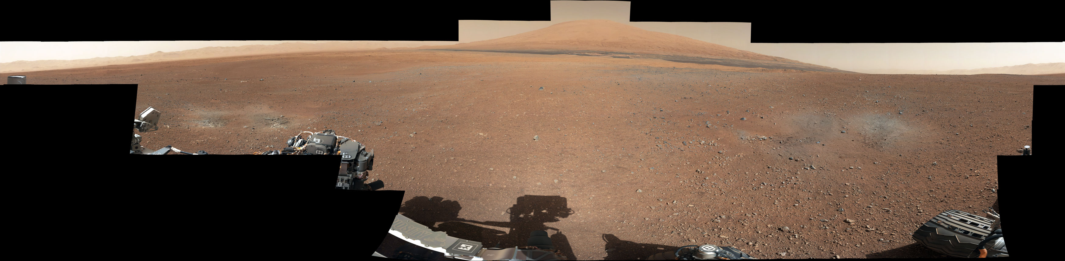
[spoiler=Color Photo, Panorama]This color panorama shows a 360-degree view of the landing site of NASA's Curiosity rover, including the highest part of Mount Sharp visible to the rover. That part of Mount Sharp is approximately 12 miles (20 kilometers) away from the rover.
[/spoiler]
[spoiler=BW Photo, Second Drive]This image taken by NASA's Curiosity rover shows track marks from a successful drive to the scour mark known as Goulburn, an area of bedrock exposed by thrusters on the rover's descent stage. The scour mark cannot be seen in this view.
This is a full-resolution image from the rover's Navigation camera. In Curiosity's second drive, it rotated about 90 degrees, drove about 16 feet (5 meters), then rotated back about 120 degrees to face roughly the same direction from which it started.
And in case you missed this gem of a side-note story from the NY Times Art Beats:
New Will.i.am Song Broadcast From Mars August 28, 2012, 4:34 pm
In the first-ever planet-to-planet music broadcast, NASA’s Mars rover, Curiosity, beamed a new song by Will.i.am of the Black Eyed Peas to Earth on Tuesday, playing an mp3 file to an audience of engineers and students at the agency’s Jet Propulsion Laboratory in Pasadena, Calif.
“Why do they say the sky is the limit when I’ve seen the footprints on the moon?” Will.i.am sings in the song, “Reach for the Stars,” which made its solar system premiere after a 330-million-mile trip, from Earth to Mars and back again. (Alas, any nearby Martians were out of luck: the rover does not have speakers to broadcast music to its surrounding landscape, and the thin Martian air would have distorted the sound.)
The song debut, part of Will.i.am’s efforts to cheerlead for science and mathematics education, did not require any advances in space technology, but perhaps reflected a more media-savvy approach by the space agency in making its work seem glamorous. The singer was among a parade of celebrities who descended on the Jet Propulsion Laboratory on Aug. 5 to watch Curiosity, an automobile-sized mobile science laboratory, touch down on Mars; others included the actor Morgan Freeman, the director Barry Sonnenfeld, the comedian Seth Green and the actress Nichelle Nichols (who played Lt. Uhura on the original Star Trek).
But this is not the first time that NASA has dabbled in music from outer space. The radio emissions of Saturn, recorded by the Cassini spacecraft, were shifted into audible frequencies, and the Kronos Quartet then incorporated the space sounds into a composition called “Sun Rings.” In 2008, NASA celebrated the 40th anniversary of the Beatles song “Across the Universe” by transmitting it into deep space.
So far, the galaxy appears ungrateful. “Obviously, deep space hasn’t sent us anything back,” a NASA spokeswoman noted.
The world is broke, the people are broke, governments are going down and bankrupt, but we spends endless amounts of money to go to a world we will never inhabit....such morons
Mageplunka69 wrote:The world is broke, the people are broke, governments are going down and bankrupt, but we spends endless amounts of money to go to a world we will never inhabit....such morons
If you think the drop in the bucket that NASA (or any similar program) spends could fix the world's problems, you are probably pretty misguided.
Here is another update, with some BW Photos of the Rover and Color Photos of the landscape...plus an Easter Egg of scientist humor and ingenuity.
On Aug. 28, 2012, during the 22nd Martian day, or sol, after landing on Mars, NASA's Curiosity rover drove about 52 feet (16 meters) eastward, the longest drive of the mission so far.
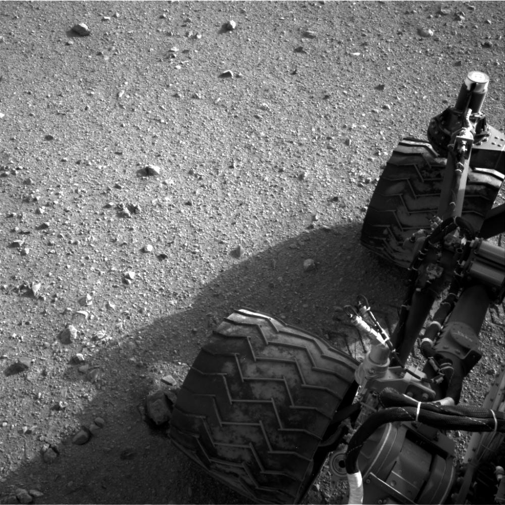
[spoiler=BW Photo, Rover Wheels and Soil]Soil clinging to the right middle and rear wheels of NASA's Mars rover Curiosity can be seen in this image taken by the Curiosity's Navigation Camera after the rover's third drive on Mars. The drive of about 52 feet (16 meters) during the 22nd Martian day, or sol, of the mission (Aug. 28, 2012), covered more ground than the two previous drives combined.
[/spoiler]
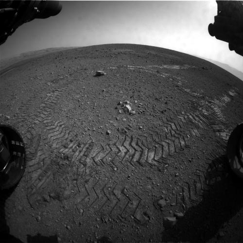
[spoiler=BW Photos, Rover Tracks and Easter Egg]This image shows a close-up of track marks from the first test drive of NASA's Curiosity rover. The rover's arm is visible in the foreground. A close inspection of the tracks reveals a unique, repeating pattern: Morse code for JPL. This pattern, visible as straight bands across the zigzag track marks, can be used as a visual reference to help the rover drive accurately.
Curiosity's "visual odometry" software measures terrain features -- such as rocks, rock shadows and patterns in the rover tracks -- to determine the precise distance between drive steps. Knowing how far it has traveled is important for measuring any wheel slippage that may have occurred, for instance due to high slopes or sandy ground. Fine-grained terrains generally lack interesting features, so Curiosity can make its own features using its wheel tracks.
The Morse code, imprinted on all six wheels, is: .--- (J), .--. (P), and .-.. (L). JPL is short for NASA's Jet Propulsion Laboratory in Pasadena, Calif., where the rover was built and the mission is managed.
[/spoiler]
[spoiler=Color Panorama Photos, Un-enhanced and color balanced]This color panorama shows a 360-degree view of the landing site of NASA's Curiosity rover, including the highest part of Mount Sharp visible to the rover. That part of Mount Sharp is approximately 12 miles (20 kilometers) away from the rover.
The images were obtained by the rover's 34-millimeter Mast Camera. The mosaic, which stretches about 29,000 pixels across by 7,000 pixels high, includes 130 images taken on Aug. 8 and an additional 10 images taken on Aug. 18. These images were shot before the camera was fully characterized.
Scientists enhanced the color in the second version to show the Martian scene as it would appear under the lighting conditions we have on Earth, which helps in analyzing the terrain.
NASA's Mars rover Curiosity drove about 70 feet (about 21 meters) on the mission's 21st Martian day, or sol (Aug. 30, 2012) and then took images with its Navigation Camera that are combined into this scene, which includes the fresh tracks. The view is centered toward the west-northwest.
[spoiler=BW Stitched Photo, Looking Back at Tracks][/spoiler]
A mosaic of about 10-12 images acquired by Curiosity's Mars Hand Lens Imager (MAHLI) instrument on Sol 612-613 (April 27, 2014) showing a "selfie" of the rover and the interior of Gale Crater, with Mt Sharp (eventual destination) in the background.
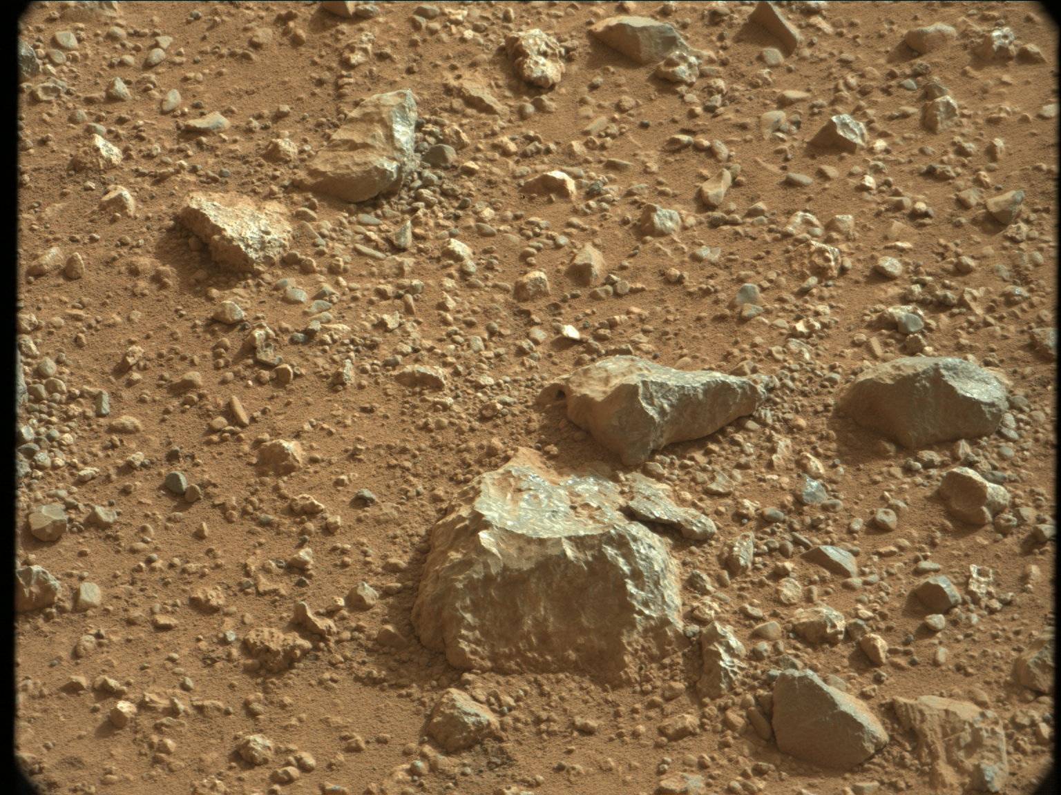
And here is a hole it recently drilled:
The rover has drilled a hole in sandstone. It will soon collect samples to learn more about how the rocks formed.


 [/spoiler]
 [/spoiler]


 [/spoiler]
 [/spoiler]
 [/spoiler]
 [/spoiler]
 [/spoiler]
 [/spoiler]
 [/spoiler]
 [/spoiler]
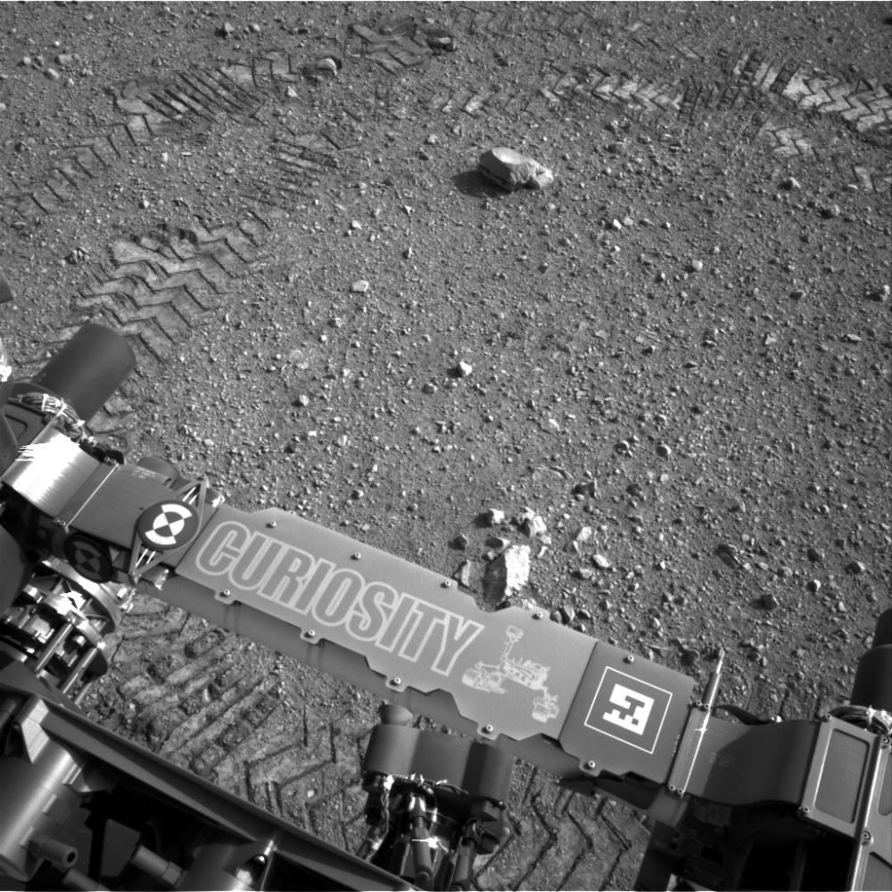
 [/spoiler]
 [/spoiler]
 [/spoiler]
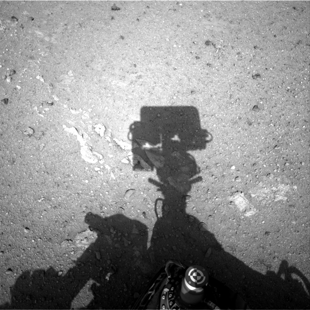 [/spoiler]
 [/spoiler]
 [/spoiler]


