CLASSIC CITIES: Sydney [Quenched]

Care to peruse completed maps? Take a stroll through the Atlas.

Moderator: Cartographers

Forum rules
Please read the Community Guidelines before posting.
Post Reply
User avatar
cairnswk
Posts: 11510
Joined: Sat Feb 03, 2007 8:32 pm
Gender: Male
Location: Australia

CLASSIC CITIES: Sydney [Quenched]

Post by cairnswk »

CLASSIC CITIES: SYDNEY

ImageImageImage Image ImageImage

Draft Stamped: 18/3/12
Gameplay Stamped: 9/5/12
Graphics Stamped: 23/8/12
XML Stamped 8/10/12
BETA Stamped 01/11/12

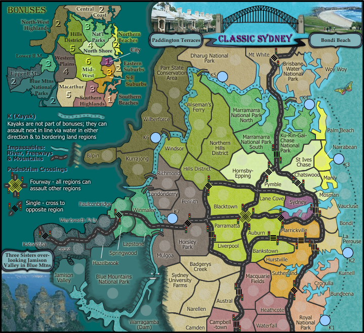
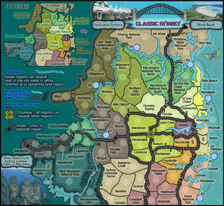
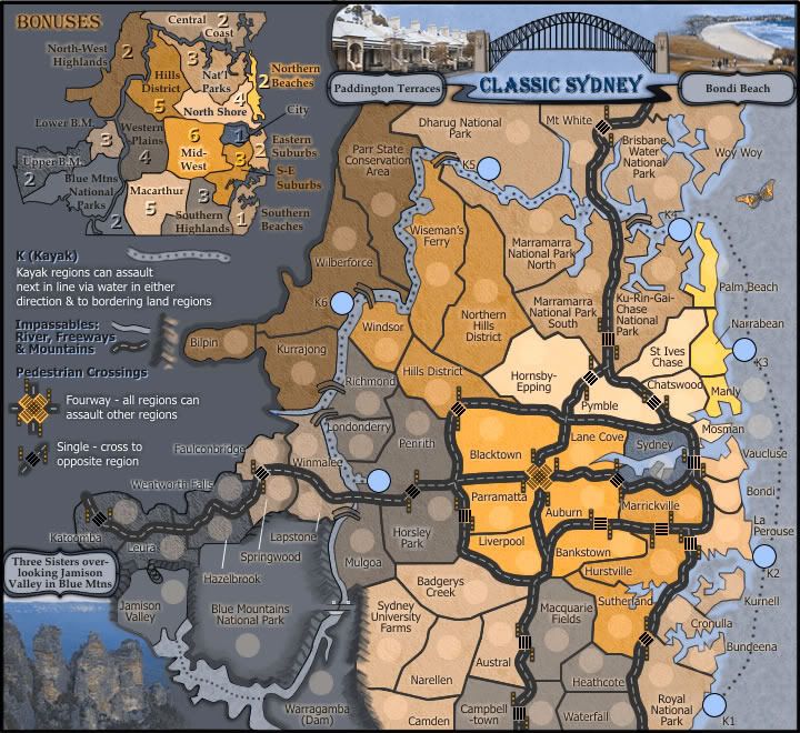
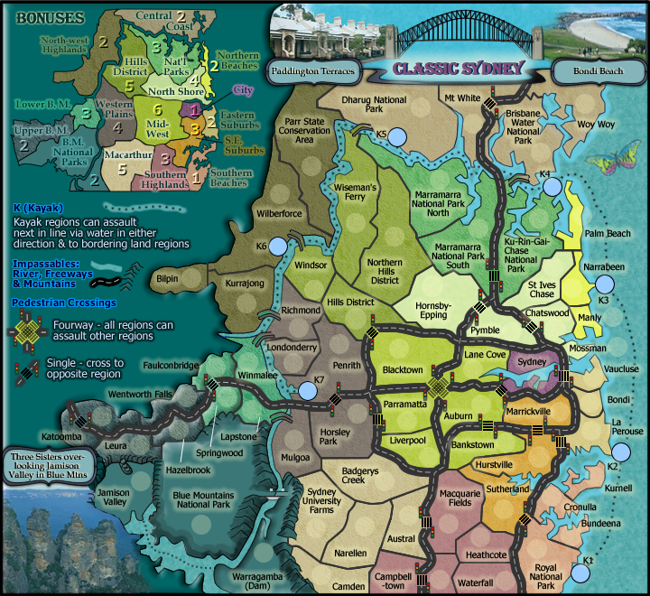
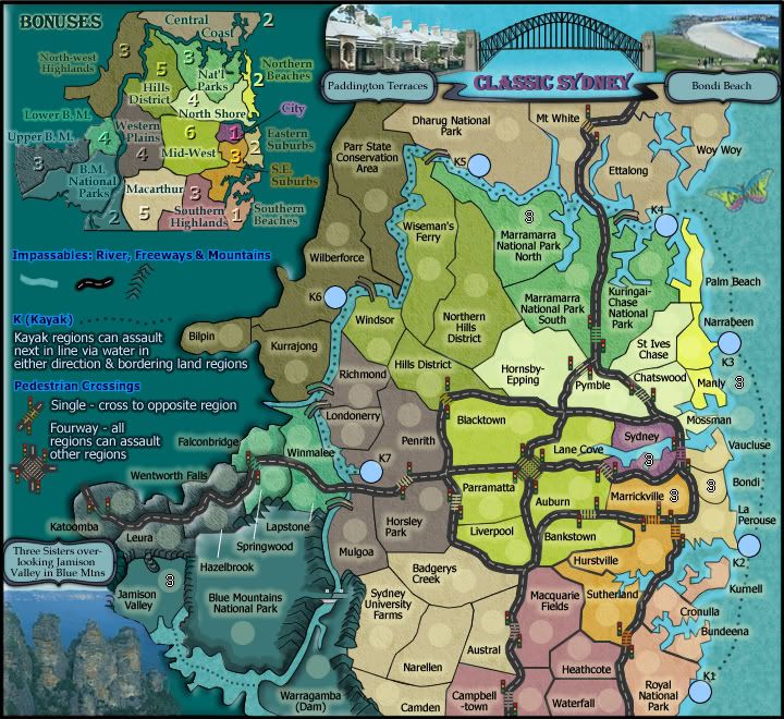
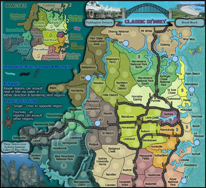
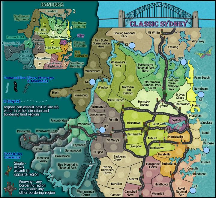
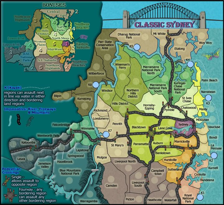
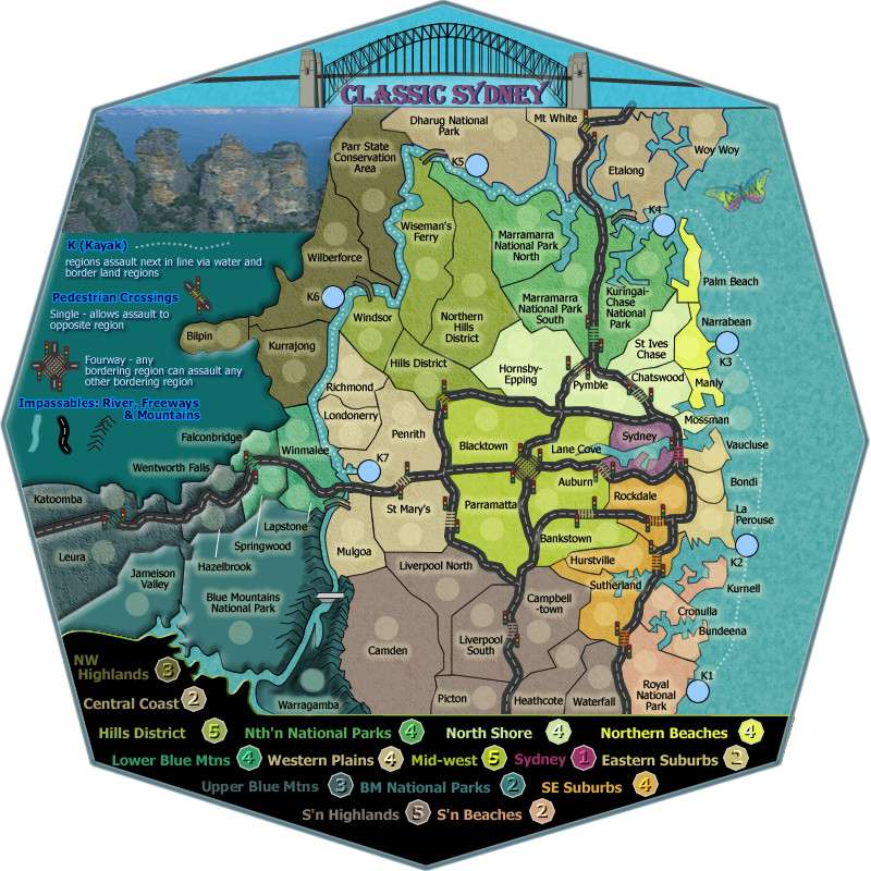
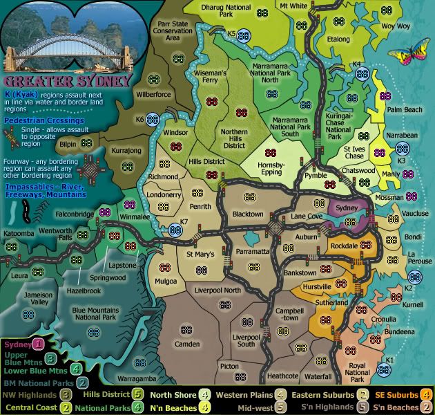
Map Name: Classic Cities: Sydney
Mapmaker(s): Cairnswk
Territories:72 regions, Continents:17 bonus continents, i (Kayaks) has no bonus, 6 starting neutrals
Gameplay Style: Classic
Gameplay features: Starting Neutrals, Impassables, Ranged attacks
Software:Fireworks CS3, Coreldraw X4
Fonts Used: GazetteCapsSSK, Tahoma, Book Antiqua
Map Description: The map is based on the wider Sydney region that includes the northern National Parks, and western Blue Mountains regions using the natural barriers of the mountains, Hawkesbury River, and inlets as impassables. The Sydney Metro map fits well within these bounrdaries.

Size:Small - 720W x 660H; Large - 800W x 773H

Version 21- Small
Image

Version 21 - Large
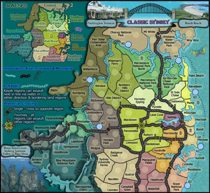
[bigimg]http://i155.photobucket.com/albums/s282/cairnswk/CC_Sydney/classic_sydney_v21L.png[/bigimg]

XML v21
http://www.fileden.com/files/2011/10/26 ... neyv20.xml

[spoiler=88 centering]
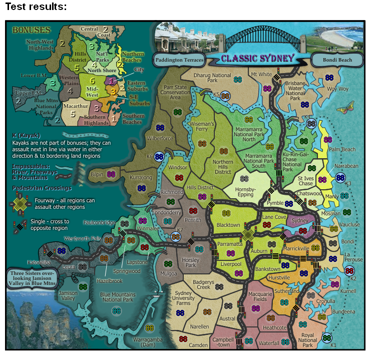
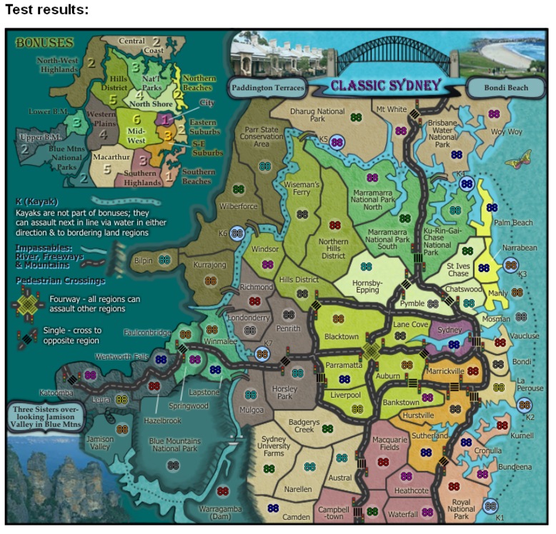
Image

Image[/spoiler]

Neutral Starts
Image

Colour-blind Version 20
show


[spoiler=Previous Versions]http://i155.photobucket.com/albums/s282/cairnswk/CC_Sydney/classic_sydney_v17S.png
http://i155.photobucket.com/albums/s282 ... y_v16S.png
http://i155.photobucket.com/albums/s282 ... y_v15S.jpg
http://i155.photobucket.com/albums/s282 ... y_v14S.jpg
http://i155.photobucket.com/albums/s282 ... y_v13S.jpg
http://i155.photobucket.com/albums/s282 ... y_v12S.jpg
http://i155.photobucket.com/albums/s282 ... y_v11S.jpg
http://i155.photobucket.com/albums/s282 ... y_v10S.jpg
http://i155.photobucket.com/albums/s282 ... _v09aS.jpg
http://i155.photobucket.com/albums/s282 ... y_v08S.png
http://i155.photobucket.com/albums/s282 ... y_v07S.png
http://i155.photobucket.com/albums/s282 ... y_v06S.jpg
http://i155.photobucket.com/albums/s282 ... y_v05S.jpg
http://i155.photobucket.com/albums/s282 ... r_v04S.jpg
http://i155.photobucket.com/albums/s282 ... r_v02S.jpg
Image[/spoiler]

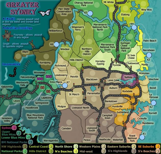
Map Name: formerly Greater Sydney - now Classic Cities: Sydney
Your aims/design style: Style is almost set, similar to the Sydney Metro map using similar design features.
Uniqueness: The combination of the geographic features combined with highway impassables, makes this a sister map for the Sydney Metro map, and for those Australian players on the site. I doubt if anyone would see anything totally unique about it, except for cairnswk it is unique in that it is has classic gamplay. ;)
29.1.12 - However, since Sydney is on the classic cities map, i will now put this forward as the classic cities offering.
Software Used:Fireworks CS3
Last edited by cairnswk on Fri Nov 09, 2012 4:40 pm, edited 64 times in total.
Image
* Pearl Harbour * Waterloo * Forbidden City * Jamaica * Pot Mosbi
User avatar
natty dread
Posts: 12877
Joined: Fri Feb 08, 2008 8:58 pm
Location: just plain fucked

Re: Greater Sydney V1

Post by natty dread »

Wow cairns. To be totally honest... if you're going to un-retire I'd rather you'd pull up Salem's Switch again - I loved that map.


(not that I dislike this one though... it's just that I've never been to Sydney so I can't really relate with this map.. )
Image
User avatar
fumandomuerte
Posts: 620
Joined: Sat Dec 29, 2007 1:27 am
Gender: Male
Location: The Cinderella of the Pacific

Re: Greater Sydney V1

Post by fumandomuerte »

Wow, welcome back boss.
Image
Thanks to the CC staff for the perma-ban on [player]۩░▒▓₪№™℮₪▓▒░۩[/player]!
User avatar
Industrial Helix
Posts: 3462
Joined: Mon Jul 14, 2008 6:49 pm
Gender: Female
Location: Ohio

Re: Greater Sydney V1

Post by Industrial Helix »

Not a fan of the roads, they look way to complicated.
Sketchblog [Update 07/25/11]: http://indyhelixsketch.blogspot.com/
Living in Japan [Update 07/17/11]: http://mirrorcountryih.blogspot.com/
Russian Revolution map for ConquerClub [07/20/11]: viewtopic.php?f=241&t=116575
User avatar
cairnswk
Posts: 11510
Joined: Sat Feb 03, 2007 8:32 pm
Gender: Male
Location: Australia

Re: Greater Sydney V1

Post by cairnswk »

Industrial Helix wrote:Not a fan of the roads, they look way to complicated.

Ah. Roads are not that complicated. They ar impassables like rivers and mountains, except at the pedestrain crossings.
It's a region map with impassables, that's all.
Image
* Pearl Harbour * Waterloo * Forbidden City * Jamaica * Pot Mosbi
User avatar
Evil DIMwit
Posts: 1616
Joined: Thu Mar 22, 2007 1:47 pm
Gender: Male
Location: Philadelphia, NJ

Re: Greater Sydney V1

Post by Evil DIMwit »

Is there no crossing at Rockdale? It looks like it should have one.
ImageImage
User avatar
cairnswk
Posts: 11510
Joined: Sat Feb 03, 2007 8:32 pm
Gender: Male
Location: Australia

Re: Greater Sydney V1

Post by cairnswk »

Evil DIMwit wrote:Is there no crossing at Rockdale? It looks like it should have one.

Oh! how did i miss that?
You are correct. That is now corrected in V1.
Image
* Pearl Harbour * Waterloo * Forbidden City * Jamaica * Pot Mosbi
User avatar
ustus
Posts: 291
Joined: Thu Nov 20, 2008 3:49 pm

Re: Greater Sydney V1

Post by ustus »

I like the roads as impassables idea. It lets you divide up an area that doesn't have any natural divisions by including what I'm guessing is a major roadway? anyway, just a thought, at first glance it currently looks like the four-way assaults EVERY territory. Upon reading what the other crossings do, I think you meant every territory that touches the four-way? might be a good idea to clarify that (though... the xml will only give you the options of the ones it actually attacks, so it doesn't have to be perfectly clear...)
ManBungalow
Posts: 3431
Joined: Sun Jan 13, 2008 7:02 am
Location: On a giant rock orbiting a star somewhere

Re: Greater Sydney V1

Post by ManBungalow »

Looks great! Sydney has awesome geographical potential to have very fun gameplay, and I like what you've got going for the ferry system.

However, I'm sure that it will need some more 'flavour'. I know it's in the 'gameplay only' stage, but I need to see the harbour bridge, opera house etc. on here before I give it the ManBungalow stamp of approval.
Image
User avatar
cairnswk
Posts: 11510
Joined: Sat Feb 03, 2007 8:32 pm
Gender: Male
Location: Australia

Re: Greater Sydney V1

Post by cairnswk »

ustus wrote:I like the roads as impassables idea. It lets you divide up an area that doesn't have any natural divisions by including what I'm guessing is a major roadway? anyway, just a thought, at first glance it currently looks like the four-way assaults EVERY territory. Upon reading what the other crossings do, I think you meant every territory that touches the four-way? might be a good idea to clarify that (though... the xml will only give you the options of the ones it actually attacks, so it doesn't have to be perfectly clear...)

OK thanks, i've changed that fourway crossing in the legend. this should read better in V2.

ManBungalow wrote:Looks great! Sydney has awesome geographical potential to have very fun gameplay, and I like what you've got going for the ferry system.

However, I'm sure that it will need some more 'flavour'. I know it's in the 'gameplay only' stage, but I need to see the harbour bridge, opera house etc. on here before I give it the ManBungalow stamp of approval.

Ah MB, that's not a ferry system, it's a kyak, as it is possible to paddle all that way around in a couple of days. The ferries are only inner Harbour routes and these are already relfected in the Sydney Metro map that is in play, so they won't be in this map.
Also the Opera House is already on the Sydney Metro map, so it won't be here on this map either, neither will the Harbour Bridge.
For identification, if you want some 'icon' then the Blue Mountains would be the most appropriate, so perhaps the Three Sisters, might be the best recognised icon.
Image
* Pearl Harbour * Waterloo * Forbidden City * Jamaica * Pot Mosbi
User avatar
cairnswk
Posts: 11510
Joined: Sat Feb 03, 2007 8:32 pm
Gender: Male
Location: Australia

Re: Greater Sydney V2

Post by cairnswk »

Version 2

Image
Image
* Pearl Harbour * Waterloo * Forbidden City * Jamaica * Pot Mosbi
User avatar
Industrial Helix
Posts: 3462
Joined: Mon Jul 14, 2008 6:49 pm
Gender: Female
Location: Ohio

Re: Greater Sydney V2

Post by Industrial Helix »

I wonder if some sort of bridge or overpass might be more appropriate instead of pedestrian walkways. Just the notion of armies looking for a zebra crossing seems a tad ridiculous to me.

I also think the army circle clutter up the map and are unnecessary. Some sort of port icon for the water routes would be nice though.

I think the glow on the words is a bit heavy, tone it down a tad?

Why does the BM National Parks have that fake 3d effect to it? I'd prefer that it was flat like the rest of the map.

The four corner border in eastern suburbs... if they all border each other with the roads then why is it necessary to have a road running through it? Furthermore, four way borders are generally discouraged on CC maps.

Some of the roads just seem unnecessary on the whole. I'm not saying the roads are a bad idea but that maybe the roads aren't doing what you want them to do. There's the example I gave above. There's also the northern road where the ped. crossings essentially make it so that the road isn't there. The only way they act as impassables is blocking St. Ives, which you could do by changing chatwood's border so it cuts st. ives off. The other roads are much more effective as impassables though. However, where does the ped crossing go to in Hurstville?

Hope some of this helps!

Lower blue mountains area is a bit cluttered... i wonder if cutting a territory out would help?
Sketchblog [Update 07/25/11]: http://indyhelixsketch.blogspot.com/
Living in Japan [Update 07/17/11]: http://mirrorcountryih.blogspot.com/
Russian Revolution map for ConquerClub [07/20/11]: viewtopic.php?f=241&t=116575
User avatar
Victor Sullivan
Posts: 6010
Joined: Mon Feb 08, 2010 8:17 pm
Gender: Male
Location: Columbus, OH
Contact:

Re: Greater Sydney V2

Post by Victor Sullivan »

I think the weird shape of the picture in the top left needs to be changed. I assume you're trying to make it look like binoculars, but it doesn't really work...
[player]Beckytheblondie[/player]: "Don't give us the dispatch, give us a mustache ride."

Scaling back on my CC involvement...
User avatar
cairnswk
Posts: 11510
Joined: Sat Feb 03, 2007 8:32 pm
Gender: Male
Location: Australia

Re: Greater Sydney V2

Post by cairnswk »

Victor Sullivan wrote:I think the weird shape of the picture in the top left needs to be changed. I assume you're trying to make it look like binoculars, but it doesn't really work...

Well, i think it does work. And it's similar to the shape that other binnocular views on google images give.
Why doesn't it work for you? Please explain further Victor.
Image
* Pearl Harbour * Waterloo * Forbidden City * Jamaica * Pot Mosbi
User avatar
cairnswk
Posts: 11510
Joined: Sat Feb 03, 2007 8:32 pm
Gender: Male
Location: Australia

Re: Greater Sydney V2

Post by cairnswk »

Industrial Helix wrote:I wonder if some sort of bridge or overpass might be more appropriate instead of pedestrian walkways. Just the notion of armies looking for a zebra crossing seems a tad ridiculous to me.

You well know that the theme of this map is similar to that of Metro Sydney which has the same freeway/ped crossings on it. We have both bridges and ped crossings on this map and i'd like to retain that.

I also think the army circle clutter up the map and are unnecessary.

OK, we can see about dising those.

Some sort of port icon for the water routes would be nice though.

Why would you use port icons for kyaks? They're hardly ship sizes. And the narrowness of the river doesn't really allow a jetty of any kind to be placed there graphically.

I think the glow on the words is a bit heavy, tone it down a tad?

OK that can be done.

Why does the BM National Parks have that fake 3d effect to it? I'd prefer that it was flat like the rest of the map.
Meh! OK this can be worked into something else, but i want the impression of height, and will be adding that to other areas eventually. Most of Sydney lies on a undulating plain surrounded by mountains.

The four corner border in eastern suburbs... if they all border each other with the roads then why is it necessary to have a road running through it? Furthermore, four way borders are generally discouraged on CC maps.
That's actually mid-west, but it shows that if you're having trouble identifying it by colour then that colour needs changing or another colour given to an adjacent region. It is necessary to have the roads runnings through them because that's exactly where the main freeways run. Just because CC discourages four-way corners on normal borders doesn't mean the fourway corner can't be used. That fourway corner has an element that shows graphically that fourway attacks are actually possible if it's included in the legend instructions. Think outside the box.

Some of the roads just seem unnecessary on the whole. I'm not saying the roads are a bad idea but that maybe the roads aren't doing what you want them to do. There's the example I gave above. There's also the northern road where the ped. crossings essentially make it so that the road isn't there. The only way they act as impassables is blocking St. Ives, which you could do by changing chatwood's border so it cuts st. ives off. The other roads are much more effective as impassables though.
I don't really understand what you're saying here, but can say that this is how i wish it to be displayed. Yes they allow connections between regions of the same type. I can't really understand why this is in question.

However, where does the ped crossing go to in Hurstville?

That ped crossing in Hurstville allows connection to another section of Hurstville across the freeway, which allows Hurstville to border La Perouse.

Lower blue mountains area is a bit cluttered... i wonder if cutting a territory out would help?

Possibly yes, i'd have to cut Emu Plains and make a combined Winmalee region.

Hope some of this helps!
Some yes. Thanks for the feedback. :)
Image
* Pearl Harbour * Waterloo * Forbidden City * Jamaica * Pot Mosbi
User avatar
Victor Sullivan
Posts: 6010
Joined: Mon Feb 08, 2010 8:17 pm
Gender: Male
Location: Columbus, OH
Contact:

Re: Greater Sydney V2

Post by Victor Sullivan »

cairnswk wrote:
Victor Sullivan wrote:I think the weird shape of the picture in the top left needs to be changed. I assume you're trying to make it look like binoculars, but it doesn't really work...

Well, i think it does work. And it's similar to the shape that other binnocular views on google images give.
Why doesn't it work for you? Please explain further Victor.

Okay, I'll try to explain this as best as I can. The picture is nice, don't get me wrong, but the over-lapping circles shape is a bit... squished. The circles aren't completely round and it therefore looks a bit strange. I also feel like the thick black outline emphasizes this, and therefore, makes it look worse. I know it's a small thing to get upset about and I don't mean to be harsh, it's just bothersome to me.

-Sully
[player]Beckytheblondie[/player]: "Don't give us the dispatch, give us a mustache ride."

Scaling back on my CC involvement...
User avatar
cairnswk
Posts: 11510
Joined: Sat Feb 03, 2007 8:32 pm
Gender: Male
Location: Australia

Re: Greater Sydney V2

Post by cairnswk »

Victor Sullivan wrote:
cairnswk wrote:
Victor Sullivan wrote:I think the weird shape of the picture in the top left needs to be changed. I assume you're trying to make it look like binoculars, but it doesn't really work...

Well, i think it does work. And it's similar to the shape that other binnocular views on google images give.
Why doesn't it work for you? Please explain further Victor.

Okay, I'll try to explain this as best as I can. The picture is nice, don't get me wrong, but the over-lapping circles shape is a bit... squished. The circles aren't completely round and it therefore looks a bit strange. I also feel like the thick black outline emphasizes this, and therefore, makes it look worse. I know it's a small thing to get upset about and I don't mean to be harsh, it's just bothersome to me.

-Sully


Mmmm. OK
Image
* Pearl Harbour * Waterloo * Forbidden City * Jamaica * Pot Mosbi
User avatar
Industrial Helix
Posts: 3462
Joined: Mon Jul 14, 2008 6:49 pm
Gender: Female
Location: Ohio

Re: Greater Sydney V2

Post by Industrial Helix »

Welp, this one sat a little longer than I expected it to but I got caught up with life things... so anyway, here she goes, another city map to join the ranks of the CC greats.

MOVED
Sketchblog [Update 07/25/11]: http://indyhelixsketch.blogspot.com/
Living in Japan [Update 07/17/11]: http://mirrorcountryih.blogspot.com/
Russian Revolution map for ConquerClub [07/20/11]: viewtopic.php?f=241&t=116575
User avatar
Evil DIMwit
Posts: 1616
Joined: Thu Mar 22, 2007 1:47 pm
Gender: Male
Location: Philadelphia, NJ

Re: Greater Sydney V2

Post by Evil DIMwit »

You've got a four-corner between Richmond and Hills District.

Also, do the Kyaks assault both ways, or just one way? Like, does K6 assault K5 and K7 or just K7? Or just K5?
ImageImage
User avatar
cairnswk
Posts: 11510
Joined: Sat Feb 03, 2007 8:32 pm
Gender: Male
Location: Australia

Re: Greater Sydney V2

Post by cairnswk »

Industrial Helix wrote:Welp, this one sat a little longer than I expected it to but I got caught up with life things... so anyway, here she goes, another city map to join the ranks of the CC greats.

MOVED


Thanks IH for the MOVE.

Evil DIMwit wrote:You've got a four-corner between Richmond and Hills District.

:oops: I'll fix that next version.

Also, do the Kyaks assault both ways, or just one way? Like, does K6 assault K5 and K7 or just K7? Or just K5?

The legend says: regions assault next in line via water. Also there are no arrows indicating one-ways on the map, so i would take from that assaults can occur both ways.
Image
* Pearl Harbour * Waterloo * Forbidden City * Jamaica * Pot Mosbi
User avatar
cairnswk
Posts: 11510
Joined: Sat Feb 03, 2007 8:32 pm
Gender: Male
Location: Australia

Re: Greater Sydney V2

Post by cairnswk »

That four-way corner is fixed.

Image
Image
* Pearl Harbour * Waterloo * Forbidden City * Jamaica * Pot Mosbi
User avatar
Evil DIMwit
Posts: 1616
Joined: Thu Mar 22, 2007 1:47 pm
Gender: Male
Location: Philadelphia, NJ

Re: Greater Sydney V2

Post by Evil DIMwit »

It's not exactly clear which bonuses go where. Is North Shore the one with Bondi and Vaucluse? Is Central Coast the one with Palm Beach? Why is the central thing north of the north thing?
ImageImage
User avatar
cairnswk
Posts: 11510
Joined: Sat Feb 03, 2007 8:32 pm
Gender: Male
Location: Australia

Re: Greater Sydney V2

Post by cairnswk »

Evil DIMwit wrote:It's not exactly clear which bonuses go where. Is North Shore the one with Bondi and Vaucluse? Is Central Coast the one with Palm Beach? Why is the central thing north of the north thing?

Why is Manhattan south of Harlem...who knows, thats what their district names are. Same applies here.
So what you're syaing is that you can't tell the "continents" from the legend.
Image
* Pearl Harbour * Waterloo * Forbidden City * Jamaica * Pot Mosbi
User avatar
Evil DIMwit
Posts: 1616
Joined: Thu Mar 22, 2007 1:47 pm
Gender: Male
Location: Philadelphia, NJ

Re: Greater Sydney V2

Post by Evil DIMwit »

I'm saying it's difficult, yes.
Also Harlem is an area in Manhattan.
ImageImage
User avatar
cairnswk
Posts: 11510
Joined: Sat Feb 03, 2007 8:32 pm
Gender: Male
Location: Australia

Re: Greater Sydney V2

Post by cairnswk »

Evil DIMwit wrote:I'm saying it's difficult, yes.
Also Harlem is an area in Manhattan.

Why can't you put it in a size that can be read instead of mumbling under your breath.
OMG...you know what i darnwell mean...my correction then...why is Manhattan south of Bronx.
Image
* Pearl Harbour * Waterloo * Forbidden City * Jamaica * Pot Mosbi
Post Reply

Return to “The Atlas”