
If anyone wants to volunteer to help me with the graphics, please let me know!
I lived in Austin for 6 years and absolutely love the city. It would be great to have a CC map with some of the classic landmarks around the town. I have made a rough draft that has 22 territories (more than Doodle Earth and only a couple shy of USA West). I would be willing to add more territories if needed, but I thought I'd get feedback first. Version 1.0 is below.
[spoiler=Update to v1.1]After receiving feedback, I'm going to redo the map making use of different areas of Austin as "neighborhoods." Within a neighborhood, territories can attack each other, but from one neighborhood to another, only territories along the highways can attack each other. I have drawn out a very rough draft by hand and would like some feedback before I go through the trouble of drawing it out on GIMP. I present, Austin, Texas Version 1.1:[/spoiler]
Update to v1.2.1
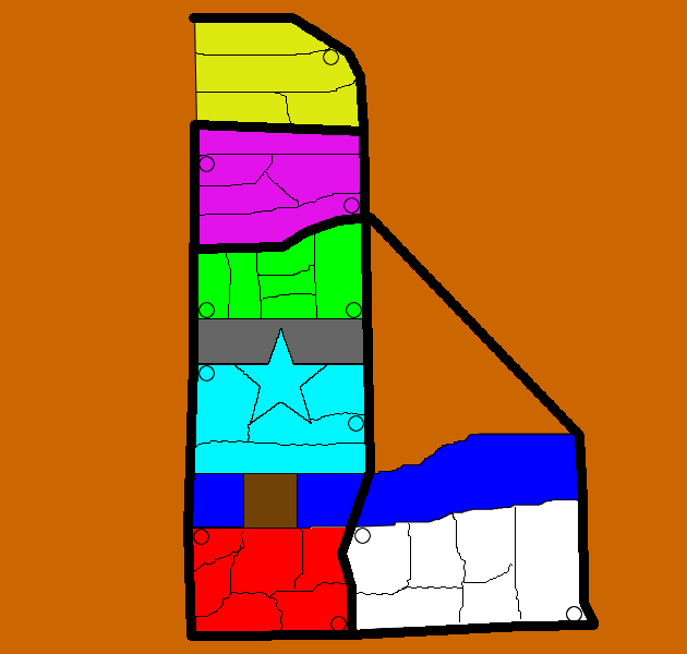
Alright, another rough drawing, this time in GIMP. All highways (thick, black lines) are impassable. You can only get from one neighborhood to the next by going from a territory with a circle in it to another along the same highways. I'm not sure if all circles should be connected or not. For example, if you want to go from the airport (bottom right whit territory) to Round Rock (yellow), you would have to assault Braker (pink) first. Hope that makes sense. I'll label the territories soon, but until then you can use v1.1 for reference. Labels have been added to the territories.
[bigimg]http://s170.photobucket.com/albums/u245/UTAlan/Conquer%20Club%20Maps/austin-1_2_1.png[/bigimg]
Territory List
Round Rock
* Georgetown
* Round Rock
* Pflugerville
* Wells Branch
North Austin
* Braker
* Arboretum
* North Lamar
* Far West
* Koenig
Campus
* West Campus
* The Drag
* Union
* Tower
* Library
* Memorial Stadium
Downtown
* Enfield
* Capitol
* "Ridge" Hospital (not sure if I can use the name Breckenridge)
* Sixth Street
* Cesar Chavez
Congress Street Bridge
South Austin
* Zilker Park
* South Congress
* St. Ed's
* South Lamar
* Manchaca
* Ben White
Riverside
* Riverside
* Pleasant Valley
* Lakeshore Park
* Oltorf
* Montopolis
* Austin-Bergstrom International Airport
Previous Versions:
Version 1.2.0
Version 1.1
Version 1.0
Austin, Texas, v1.2.1, pg. 2
Moderator: Cartographers
Forum rules
Please read the Community Guidelines before posting.
Please read the Community Guidelines before posting.
Austin, Texas, v1.2.1, pg. 2
Last edited by UTAlan on Thu Mar 11, 2010 2:57 pm, edited 9 times in total.
Top Score: 2105 11/21/09

Re: Austin, Texas v1.0
Are the intersecting territories in both bonuses? and the white needs to be wroth maybe 3 not 2.
Re: Austin, Texas v1.0
ask me2 wrote:Are the intersecting territories in both bonuses?
As of now, yes. This is the biggest thing I'm worried about with the current layout is the difficulty of getting bonuses with so many territories belonging to multiple bonuses, although I'm not sure if that's necessarily a bad thing.
and the white needs to be wroth maybe 3 not 2.
If I bump up white, I need to bump up cyan, too, because they both have 5 territories. Either way is fine.
Top Score: 2105 11/21/09
-
natty dread

- Posts: 12877
- Joined: Fri Feb 08, 2008 8:58 pm
- Location: just plain fucked
Re: Austin, Texas v1.0
More territories please. Take a look at the chicago map, if you can pull of something similar then you might have something worth developing. Right now what you have is a bunch of lines and dots that don't really remind me of a city map.

Re: Austin, Texas v1.0
I live here now, and have for 20 years. A couple of comments:
Austin has very limited east west access - if you can figure out a way to reflect that it would make the map interesting. In other words make the geography play a larger role. By the way the Capitol is about 2 miles from Town Lake - between 11th and 15th streets.
SH-1 ? Come on, that's Mopac.
And University? That has to be UT or Concordia alums might lay claim to it.
I'm not sure that the highways are a bad idea - Mopac, 35, 183, and 71 dominate Austin but having neighborhoods touch each other with highways allowing "jumps" might be a better approach.
Dan
Re: Austin, Texas v1.0
natty_dread wrote:More territories please. Take a look at the chicago map, if you can pull of something similar then you might have something worth developing. Right now what you have is a bunch of lines and dots that don't really remind me of a city map.
This is my first map, so I felt pretty clueless starting from scratch. I looked at Chicago and like it a lot. I'll see if I can integrate the neighborhoods of Austin into the map without losing the highway concept.
Top Score: 2105 11/21/09
Re: Austin, Texas v1.0
danryan wrote:Austin has very limited east west access - if you can figure out a way to reflect that it would make the map interesting. In other words make the geography play a larger role.
I like this. Any suggestions? Were you thinking making use of one way attack routes to limit east-west assaults?
By the way the Capitol is about 2 miles from Town Lake - between 11th and 15th streets.
Yeah, I struggled with this decision, just as I did with UT. I was trying to force them to fit onto the highways and the lake, although with natty's suggestion I can probably fix this.
SH-1 ? Come on, that's Mopac.
Heh. I was going for consistency with the other highways, but I think I agree with you. Anyone from Austin knows it as Mopac.
And University? That has to be UT or Concordia alums might lay claim to it.
My only concern there is copyright. Maybe if I call it "The University"?
I'm not sure that the highways are a bad idea - Mopac, 35, 183, and 71 dominate Austin but having neighborhoods touch each other with highways allowing "jumps" might be a better approach.
Dan
Thanks. As I said to natty, I'll have to reevaluate my approach and maybe come from a neighborhood layout with highways overlayed on top.
I appreciate the feedback!
Top Score: 2105 11/21/09
Re: Austin, Texas v1.0
One-way attacks could be cool across I-35. There are just a few major crossings on it anyway - 1st st (Cesar Chavez), 5th, 11th St, MLK, etc. If you tighten the map up to the neighborhoods in the Austin city limits itself you'll improve the map focus - Lockhart, Cedar Park, etc. aren't really Austin.
I just saw Natty's post and I agree with the idea of the highways lying on top of the map as connectors between far reaching points - instead of train lines like Chicago use the highways.
Good luck!
I just saw Natty's post and I agree with the idea of the highways lying on top of the map as connectors between far reaching points - instead of train lines like Chicago use the highways.
Good luck!
-
Artic patrol
- Posts: 157
- Joined: Tue Jan 27, 2009 1:17 pm
Re: Austin, Texas v1.0
That is a cool map!

Re: Austin, Texas v1.0
The white bonus should be increased. I know you already said NO before, but the bonus are discovered by the hardest is to keep the region, and not for the many territories it has.
-
natty dread
- Posts: 12877
- Joined: Fri Feb 08, 2008 8:58 pm
- Location: just plain fucked
Re: Austin, Texas v1.0
Rih0 wrote:The white bonus should be increased. I know you already said NO before, but the bonus are discovered by the hardest is to keep the region, and not for the many territories it has.
Actually, both should be considered when deciding bonus values.
There's a bonus calculator for these kinds of things. It can be found on the foundry tips & discussion forum.
The formula for calculating bonus value for a bonus area goes like this:
(Number of territories) x 1.5
(Number of borders) x 4
(Number of territories that can attack the bonus area) x 1
(Number of bordering bonus areas) x 0.5
Add the results together and divide by 6.
So if we for example take the cyan bonus in this draft, we have:
5 territories x 1.5 = 7.5
3 borders x 4 = 12
5 attacking territories x 1 = 5
4 bonus area neighbours x 0.5 = 2
7.5 + 12 + 5 + 2 = 26.5
26.5 /6 = 4.425 rounded up to 4.
So according to the formula the cyan areas bonus would be 4.
But, first figure out the territories, and make a draft with more than just dots and lines. Bonus value calculations can come later.
Re: Austin, Texas v1.0
Thanks for the heads up on the bonus calculator. I'm not too concerned about bonuses as of yet, as natty said. I've hand-drawn a new map, but it will take me a bit to draw it up in GIMP. I'll be sure to update this thread when I have something to show for it.
Thanks again for the suggestions and tips.
Thanks again for the suggestions and tips.
Top Score: 2105 11/21/09
Re: Austin, Texas v1.1
Update to Version 1.1 - See original post.
[bigimg]http://s170.photobucket.com/albums/u245/UTAlan/Conquer%20Club%20Maps/austin-1_1.png[/bigimg]
My original thought was that highways would be impassable, as would areas marked with "/////" (e.g. 45th St, MLK, etc). The only problem is neighborhoods that span over a highway (e.g. Riverside, North Austin, etc). My current workaround is to have a single territory span across (or under?) a highway. Any suggestions on this problem are welcome.
(I could always just fudge the borders a little, putting Braker below 183 or ABIA west of 183, but I'd like to avoid that if possible.)
Last edited by UTAlan on Wed Feb 24, 2010 3:24 pm, edited 1 time in total.
Top Score: 2105 11/21/09
-
porkenbeans

- Posts: 2546
- Joined: Mon Sep 10, 2007 4:06 pm
Re: Austin, Texas v1.1
love the idea of an Austin map.
I think the best way to start, is to just make a list of all the places in and around Austin, that really gets to the heart of the place. Town lake and Barton Springs, Lake Travis and Hippy hollow, The park where Austin City Limits is filmed, The Capitol, Ut campus, All the nite hot spots that Willy Nelson likes to drop in on. After you have all of those key places spread out on the map, then you can overlay some of the main highways, and set them up as separate bonuses. Once you get everything sprawled out on the map, then you can start to consider just how you can pull it all together. I love Austin, and will certainly be following along closely with this project.
I think the best way to start, is to just make a list of all the places in and around Austin, that really gets to the heart of the place. Town lake and Barton Springs, Lake Travis and Hippy hollow, The park where Austin City Limits is filmed, The Capitol, Ut campus, All the nite hot spots that Willy Nelson likes to drop in on. After you have all of those key places spread out on the map, then you can overlay some of the main highways, and set them up as separate bonuses. Once you get everything sprawled out on the map, then you can start to consider just how you can pull it all together. I love Austin, and will certainly be following along closely with this project.

Re: Austin, Texas v1.1
porkenbeans wrote:love the idea of an Austin map.
I think the best way to start, is to just make a list of all the places in and around Austin, that really gets to the heart of the place. Town lake and Barton Springs, Lake Travis and Hippy hollow, The park where Austin City Limits is filmed, The Capitol, Ut campus, All the nite hot spots that Willy Nelson likes to drop in on. After you have all of those key places spread out on the map, then you can overlay some of the main highways, and set them up as separate bonuses. Once you get everything sprawled out on the map, then you can start to consider just how you can pull it all together. I love Austin, and will certainly be following along closely with this project.
Austin City Limits is filmed in a Studio, with a fake skyline painted on a canvas. Now the ACL festival is actually in Zilker park and involves a lot of mud.
I like the new map a lot - with some work I think this will be a wiener!
Re: Austin, Texas v1.2
Update to Version 1.2 - see original post.
[bigimg]http://i170.photobucket.com/albums/u245/UTAlan/Conquer%20Club%20Maps/austin-1_2.png[/bigimg]
Sorry for the lack of labels - I'll get on that as soon as I have the chance. Also, I know it's looking ugly right now, but I'm going for layout more than looks. I can clean up the visuals later.
[bigimg]http://i170.photobucket.com/albums/u245/UTAlan/Conquer%20Club%20Maps/austin-1_2.png[/bigimg]
Sorry for the lack of labels - I'll get on that as soon as I have the chance. Also, I know it's looking ugly right now, but I'm going for layout more than looks. I can clean up the visuals later.
Last edited by UTAlan on Wed Feb 24, 2010 3:24 pm, edited 1 time in total.
Top Score: 2105 11/21/09
Re: Austin, Texas v1.2
UTAlan wrote:Update to Version 1.2 - see original post.
Sorry for the lack of labels - I'll get on that as soon as I have the chance. Also, I know it's looking ugly right now, but I'm going for layout more than looks. I can clean up the visuals later.
Looks great so far! Keep up the good work.

Re: Austin, Texas v1.2
UTAlan wrote:Update to Version 1.2 - see original post.
When you post an update, it helps to post the images to the thread, as well as updating the first post - it helps to follow the development of the map to see how it progresses over time.

PB: 2661 | He's blue... If he were green he would die | No mod would be stupid enough to do that
Re: Austin, Texas v1.2
MrBenn wrote:UTAlan wrote:Update to Version 1.2 - see original post.
When you post an update, it helps to post the images to the thread, as well as updating the first post - it helps to follow the development of the map to see how it progresses over time.
Good to know. Thank you.
Top Score: 2105 11/21/09
Re: Austin, Texas, v1.2.1, pg. 2
Update to Version 1.2.1
Labels added. Please give me any feedback you have. I'm looking for someone to help me with the graphics, but in the meantime I'd like to work on the layout and gameplay.
[bigimg]http://s170.photobucket.com/albums/u245/UTAlan/Conquer%20Club%20Maps/austin-1_2_1.png[/bigimg]
Labels added. Please give me any feedback you have. I'm looking for someone to help me with the graphics, but in the meantime I'd like to work on the layout and gameplay.
[bigimg]http://s170.photobucket.com/albums/u245/UTAlan/Conquer%20Club%20Maps/austin-1_2_1.png[/bigimg]
Top Score: 2105 11/21/09
Re: Austin, Texas, v1.2.1, pg. 2
Looks great!
-
fumandomuerte

- Posts: 620
- Joined: Sat Dec 29, 2007 1:27 am
- Gender: Male
- Location: The Cinderella of the Pacific
Re: Austin, Texas, v1.2.1, pg. 2
What are the little circles standing for?

Thanks to the CC staff for the perma-ban on [player]۩░▒▓₪№™℮₪▓▒░۩[/player]!
Re: Austin, Texas, v1.2.1, pg. 2
fumandomuerte wrote:What are the little circles standing for?
Right now, the circles designate which territories connect to a highway. Since the highways are impassible, that is the only way to get from one bonus to another.
Top Score: 2105 11/21/09
-
Industrial Helix

- Posts: 3462
- Joined: Mon Jul 14, 2008 6:49 pm
- Gender: Female
- Location: Ohio
Re: Austin, Texas, v1.2.1, pg. 2
What I'd like to see from this map:
Better use of space.
Coherent Graphics (what software are you using? I may be able to help)
A legend.
A bonus structure.
Gameplay that makes this more than just another Charleston or Chicago or New York. I know everyone wants to see their hometown represented, but CC is starting to get a lot of the same maps with different names. What makes Austin unique?
Looking forward to the next update!
Sketchblog [Update 07/25/11]: http://indyhelixsketch.blogspot.com/
Living in Japan [Update 07/17/11]: http://mirrorcountryih.blogspot.com/
Russian Revolution map for ConquerClub [07/20/11]: viewtopic.php?f=241&t=116575
Living in Japan [Update 07/17/11]: http://mirrorcountryih.blogspot.com/
Russian Revolution map for ConquerClub [07/20/11]: viewtopic.php?f=241&t=116575