.44
England Map [Quenched]
Moderator: Cartographers
Forum rules
Please read the Community Guidelines before posting.
Please read the Community Guidelines before posting.
-
the.killing.44

- Posts: 4724
- Joined: Thu Oct 23, 2008 7:43 pm
- Gender: Male
- Location: now tell me what got two gums and knows how to spit rhymes
- Contact:
Re: England Map [D, GP] p1/26 - Final Graphics? Big+Small
On the small, having the bottommost lion being smaller looks very off. other than that I got nothing  Stamp soon.
.44
.44
-
brian fletcher
- SoC Training Adviser
- Posts: 570
- Joined: Tue Mar 17, 2009 2:42 pm
- Gender: Male
- Location: Bournemouth UK
Re: England Map [D, GP] p1/26 - Final Graphics? Big+Small
I dread to think how many times someone will assault middlesex from kent and end up in essex 
ive looked at this map so many times and thats the 1st time ive noticed the bottom lion being smaller.
if the drop down assault box lists derby as derbyshire then i guess ignore my previous comment as it would kind of spoil the look.
ive looked at this map so many times and thats the 1st time ive noticed the bottom lion being smaller.
if the drop down assault box lists derby as derbyshire then i guess ignore my previous comment as it would kind of spoil the look.


Re: England Map [D, GP] p1/26 - Final Graphics? Big+Small
the commonly-used postal abbreviation for derbyshire is derbys. however, it looks a bit odd to me if we put it on this map.
http://www.gazetteer.co.uk/section3.htm
a full stop appears after notts, but none of the other county abbreviations have one.
ian.
http://www.gazetteer.co.uk/section3.htm
a full stop appears after notts, but none of the other county abbreviations have one.
ian.

-
Teflon Kris

- Posts: 4236
- Joined: Sun Jul 13, 2008 4:39 pm
- Gender: Male
- Location: Lancashire, United Kingdom
Re: England Map [D, GP] p1/26 - Final Graphics? Big+Small
Minor detail - Wetmorland /Lancashire border - could you get away with it being a little bit closer to the coast?

Re: England Map [D, GP] p1/26 - Final Graphics? Big+Small
DJ Teflon wrote:Minor detail - Wetmorland /Lancashire border - could you get away with it being a little bit closer to the coast?
Wetmorland...Freudian slip there?
Important Tournament Notice
The data for ALL of my tournaments has potentially been lost. I am working to recover it but as I am away on business all of this week, there will be some delay. Sincere apologies.
The data for ALL of my tournaments has potentially been lost. I am working to recover it but as I am away on business all of this week, there will be some delay. Sincere apologies.

Re: England Map [D, GP] p1/26 - Final Graphics? Big+Small
I've been making some tweaks to the small map, but haven't had enough time to get something that I'm completely satisfied with yet.
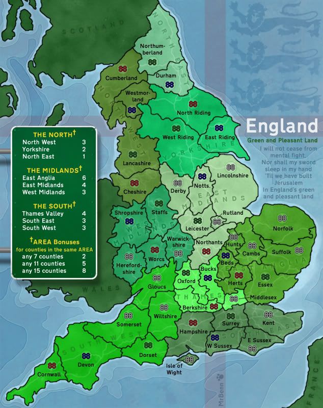
The third lion (bottom one) is often smaller than the first two, especially as they're more commonly seen on a shield (which shrinks towards the bottom)... and he needs to be smaller so as to not overlap the land...
I'll be ironing out some of the discrepencies in abbreviations (ie the full-stop in Notts.) too...
Keep watching this space

PB: 2661 | He's blue... If he were green he would die | No mod would be stupid enough to do that

Re: England Map [D, GP] p1/25 - Finalising graphics

I know MrBenn is now busy, and that he has some things he wants to do with this map...but i think it deserves a bump to remind people that it's still here...

* Pearl Harbour * Waterloo * Forbidden City * Jamaica * Pot Mosbi
Re: England Map [D, GP] p1/26 - Final Graphics? Big+Small
Woohoo... at long last I've got around to publishing an update...
I can;t really remember all the things I've done - most of them are silly little tweaks that you probably wouldn't notice unless I pointed them out in any case
The most notable thing I've done is to change the font on the small map to make it easier to read (although it's a very similar typeface to the one I was using in any case) and less blurry.
The third lion will stay slightly smaller than the other two (only on the small map), because it looks stupid if I shrink the others down to be the same size - and if I make the smallest lion any bigger, then he (his name is Dexter) will overlap the land.
PB: 2661 | He's blue... If he were green he would die | No mod would be stupid enough to do that
-
the.killing.44
- Posts: 4724
- Joined: Thu Oct 23, 2008 7:43 pm
- Gender: Male
- Location: now tell me what got two gums and knows how to spit rhymes
- Contact:
Re: England Map [D, GP] p1/26 - Final Graphics? Big+Small
*sticks tongue out at Benn*

Re: England Map [D, GP] p1/26 - Final Graphics? Big+Small
MrBenn, nice update.
Is there any reason why the white lines in the background are clearer in the South-East than in most other continents.
In some , i can't see any.
To that extent, is the transparency consistant on all continents.
Is there any reason why the white lines in the background are clearer in the South-East than in most other continents.
In some , i can't see any.
To that extent, is the transparency consistant on all continents.
* Pearl Harbour * Waterloo * Forbidden City * Jamaica * Pot Mosbi
Re: England Map [D, GP] p1/26 - Final Graphics? Big+Small
cairnswk wrote:MrBenn, nice update.
Is there any reason why the white lines in the background are clearer in the South-East than in most other continents.
In some , i can't see any.
To that extent, is the transparency consistant on all continents.
It's partially a trick of the eye - especially as I've tweaked the transparency to try and make them more visible in the paler regions....
I'll have another look at evening them up a bit - but there'll probably always be some optical trick on them...
edit: Thanks for the stamp

PB: 2661 | He's blue... If he were green he would die | No mod would be stupid enough to do that
-
Evil DIMwit

- Posts: 1616
- Joined: Thu Mar 22, 2007 1:47 pm
- Gender: Male
- Location: Philadelphia, NJ
Re: England Map [D, GP] p1/26 - Final Graphics? Big+Small
Took you long enough, man. Terrific work with all the green. 'Bout time the site got a new comedy map.*
*As a Jew I find the song "Jerusalem" inevitably hilarious.
*As a Jew I find the song "Jerusalem" inevitably hilarious.


Re: England Map [D, GP] p1/26 - Final Graphics? Big+Small
MrBenn wrote:cairnswk wrote:MrBenn, nice update.
Is there any reason why the white lines in the background are clearer in the South-East than in most other continents.
In some , i can't see any.
To that extent, is the transparency consistant on all continents.
It's partially a trick of the eye - especially as I've tweaked the transparency to try and make them more visible in the paler regions....
I'll have another look at evening them up a bit - but there'll probably always be some optical trick on them...
OKies.
I think this can be stickied at least.
* Pearl Harbour * Waterloo * Forbidden City * Jamaica * Pot Mosbi
Re: England Map [D, GP] p1/26 - Final Graphics? Big+Small
Biggest change I can see, apart from the font, is leaving out that very poem... A shame.
Dost thou fear the clutter?
Dost thou fear the clutter?


Winner of "As Easy As 1, 2, 3! - Africa I", "Championship Series: British Isles",
"1v1 Battle to Rule Doodle Earth 2", "Connect 4 (Restarted)" and "Blind Fold Buddy - BeNeLux"
-
porkenbeans

- Posts: 2546
- Joined: Mon Sep 10, 2007 4:06 pm
Re: England Map [D, GP] p1/26 - Final Graphics? Big+Small
Just stumbled onto this map. I must say with all honesty, that, It is the prettiest map I have seen. I love the style, the color, the legibility and, ...well, just the pleasant feel of it. 
Nice job there Mr. B. I would NOT change a thing.

Nice job there Mr. B. I would NOT change a thing.

Re: England Map [D, GP] p1/26 - Final Graphics? Big+Small
I've been fiddling around with the "white lines" in the background (it's actually the strategic roads network), and brough some more consistency between the appearance of them.
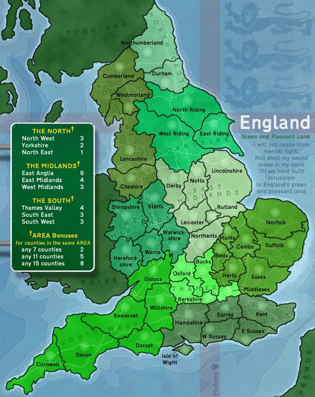
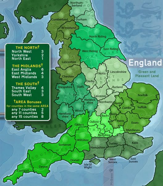
I should probably get around to doing the XML soon
I should probably get around to doing the XML soon
PB: 2661 | He's blue... If he were green he would die | No mod would be stupid enough to do that
Re: England Map [D, GP] p1/26 - Final Graphics? Big+Small
Evil DIMwit wrote:*As a Jew I find the song "Jerusalem" inevitably hilarious.
Blake had some weird theology going on - that's for sure... Quite why some people choose to sing it at their wedding is anybody's guess
PB: 2661 | He's blue... If he were green he would die | No mod would be stupid enough to do that
-
Evil DIMwit
- Posts: 1616
- Joined: Thu Mar 22, 2007 1:47 pm
- Gender: Male
- Location: Philadelphia, NJ
Re: England Map [D, GP] p1/26 - Final Graphics? Big+Small
MrBenn wrote:Evil DIMwit wrote:*As a Jew I find the song "Jerusalem" inevitably hilarious.
Blake had some weird theology going on - that's for sure... Quite why some people choose to sing it at their wedding is anybody's guess
Apparently it's attached to some old prophecy in the bible about a new Jerusalem being built. This song isn't the kookiest interpretation of that prophecy either; I've actually read of a proposal that the New Jerusalem should be an MMO-style virtual city that people can log onto and walk around...
...Maybe we should petition Lack for the relevant XML updates?
Re: England Map [D, GP] p1/26 - Final Graphics? Big+Small
Evil DIMwit wrote:MrBenn wrote:Evil DIMwit wrote:*As a Jew I find the song "Jerusalem" inevitably hilarious.
Blake had some weird theology going on - that's for sure... Quite why some people choose to sing it at their wedding is anybody's guess
Apparently it's attached to some old prophecy in the bible about a new Jerusalem being built. This song isn't the kookiest interpretation of that prophecy either; I've actually read of a proposal that the New Jerusalem should be an MMO-style virtual city that people can log onto and walk around...
...Maybe we should petition Lack for the relevant XML updates?
Somebody's probably making money from a Pseudo-Jerusalem in Second Life...
PB: 2661 | He's blue... If he were green he would die | No mod would be stupid enough to do that

Re: England Map [D, GP] p1/26 - Final Graphics? Big+Small
MrBenn wrote:Evil DIMwit wrote:MrBenn wrote:Evil DIMwit wrote:*As a Jew I find the song "Jerusalem" inevitably hilarious.
Blake had some weird theology going on - that's for sure... Quite why some people choose to sing it at their wedding is anybody's guess
Apparently it's attached to some old prophecy in the bible about a new Jerusalem being built. This song isn't the kookiest interpretation of that prophecy either; I've actually read of a proposal that the New Jerusalem should be an MMO-style virtual city that people can log onto and walk around...
...Maybe we should petition Lack for the relevant XML updates?
Somebody's probably making money from a Pseudo-Jerusalem in Second Life...
Excellent work, great improvement from the draft. Love the shades of green and this is the first map I've seen where the big map is actually different to the small one!
Re: England Map [D, GP, GR]
I've knocked up some XML: http://www.fileden.com/files/2009/1/9/2 ... and-02.xml
The only thing I have some reservations about is the naming of the abbreviated territories within the XML...
1. Gloucestershire - Gloucs
2. Gloucs / Gloucestershire
3. Gloucs - Gloucestershire
4. Gloucs (Gloucestershire)
Any thoughts/suggestions?
The only thing I have some reservations about is the naming of the abbreviated territories within the XML...
- Staffordshire (Staffs)
Worcestershire (Worcs)
Derbyshire (Derby)
Nottinghamshire (Notts)
Northamptonshire (Northants)
Bedfordshire (Beds)
Huntingdonshire (Hunts)
Cambridgeshire (Cambs)
Hertfordshire (Herts)
Oxfordshire (Oxford)
Buckinghamshire (Bucks)
Gloucestershire (Gloucs)
1. Gloucestershire - Gloucs
2. Gloucs / Gloucestershire
3. Gloucs - Gloucestershire
4. Gloucs (Gloucestershire)
Any thoughts/suggestions?
PB: 2661 | He's blue... If he were green he would die | No mod would be stupid enough to do that
Re: England Map [D, GP, GR]
Well the abbreviations should definitely go first, that's is more comfortable (especially to non-English players).
Parentheses are good for me...
Parentheses are good for me...
Winner of "As Easy As 1, 2, 3! - Africa I", "Championship Series: British Isles",
"1v1 Battle to Rule Doodle Earth 2", "Connect 4 (Restarted)" and "Blind Fold Buddy - BeNeLux"

Re: England Map [D, GP, GR]
think the abbreviation will work
-
thenobodies80

- Posts: 5400
- Joined: Wed Sep 05, 2007 4:30 am
- Gender: Male
- Location: Milan
Re: England Map [D, GP, GR]
Some people have criticized gimil's British Isles 2 because there isn't an easy pairing. (e.g. : oxon - oxfordshire), so I think that the best option is the fourth, abbreviation and parentheses.
First a player will read the territory name like it is written on the map, then he will be able to understand what is the real name (if the player wants )
By the way,
---The England Map has reached the ‘Final Forge’ Stage. The map has passed rigorous gameplay and graphics examinations, and major concerns have been addressed. If you have any other concerns, please make your voice heard. If after a reasonable amount of time there has not been any objection or protest, the map will be deemed finished with the 'Foundry Brand' of approval and will be submitted for live play. As long as there is still discussion or posts that have yet to be commented on, the map will remain in Final Forge until said discussion has reached the conclusion that the map has reached its final and polished version.
Post questions and concerns if any.
First a player will read the territory name like it is written on the map, then he will be able to understand what is the real name (if the player wants
By the way,
- Final Forge
---The England Map has reached the ‘Final Forge’ Stage. The map has passed rigorous gameplay and graphics examinations, and major concerns have been addressed. If you have any other concerns, please make your voice heard. If after a reasonable amount of time there has not been any objection or protest, the map will be deemed finished with the 'Foundry Brand' of approval and will be submitted for live play. As long as there is still discussion or posts that have yet to be commented on, the map will remain in Final Forge until said discussion has reached the conclusion that the map has reached its final and polished version.
Post questions and concerns if any.

-
the.killing.44
- Posts: 4724
- Joined: Thu Oct 23, 2008 7:43 pm
- Gender: Male
- Location: now tell me what got two gums and knows how to spit rhymes
- Contact:
Re: England Map [D, GP, GR]
Numero quatro