PLEASE VOTE FOR THE MOST FITTING DESERT IN THE POLL: [url=http://www.conquerclub.com/forum/viewtopic.php?p=358858#358858]link for the examples
[/url]
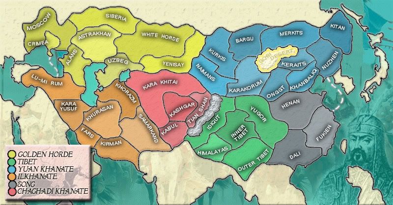
Hey guys. In my Charlemagne thread, a map of the Empire was suggested so I decided to have a crack at that. Its devided up as far as I could into relavant continents - the khanates. They can all be dated to the late 1200s which is as accurate as I could be. Not all the names are done yet, as I want to get into uni and find an accurate historical atlas for the last few.
Also, I was considering impassable borders - The border between Idiquit and the red continent definitely and I don't know where else. Havn't found a good enough way of representing mountains yet. Will try and do it for the next update. What do you think so far?
Provisional bonus:
Golden Horde - 5
Tibet - 3
Cathay Khanate - 7
Ilkhanate - 4
Yuan Khanate - 2
Chaghadi Khanate - 3
edit: have realised there is another mongol map in (early) development
Mongol Empire Map [Quenched]
Moderator: Cartographers
Forum rules
Please read the Community Guidelines before posting.
Please read the Community Guidelines before posting.
-
Guiscard

- Posts: 4103
- Joined: Fri Dec 08, 2006 7:27 pm
- Location: In the bar... With my head on the bar
Mongol Empire Map [Quenched]
Last edited by Guiscard on Sun Apr 29, 2007 8:07 pm, edited 32 times in total.
-
Lone.prophet
- Posts: 1467
- Joined: Thu Oct 12, 2006 4:37 pm
- Location: Your basement Muahaha
-
Ruben Cassar

- Posts: 2160
- Joined: Thu Nov 16, 2006 6:04 am
- Gender: Male
- Location: Civitas Invicta, Melita, Evropa


-
Lone.prophet
- Posts: 1467
- Joined: Thu Oct 12, 2006 4:37 pm
- Location: Your basement Muahaha
i like the idea of a map over the mongol empire, it was the greatest land empire in world history
for names of the territories you could use ancient names for the towns in the area such as karakorum, khanbalik, k'ai-feng, zaitun and canton
i have also found names for the areas on a map over the empire, but i'm not sure if they are names for the people in the area or names of the area it self. i'll give you the names and you could look into it a bit more
for the yuan khanate i have four names: honan in the north, fukien at the coast, yunnan in the southwest and kwang tung for the centre (might not need that one)
for the cathay khanate i have two names for the area along the coast south of the korean peninsula: shansi bordering the yuan khanate (it could even be in the yuan khanate in your map) and tenduk just north of that
the map looks good keep up the good work
-
Lone.prophet
- Posts: 1467
- Joined: Thu Oct 12, 2006 4:37 pm
- Location: Your basement Muahaha
-
Guiscard
- Posts: 4103
- Joined: Fri Dec 08, 2006 7:27 pm
- Location: In the bar... With my head on the bar
Glee, thanks for the names I'll have a look at putting them on.
Lone Prophet, I realise that that the eastern side is the empire of the great khan. I decided to split it up into three smaller continents simply for playability, and I found the most relavant names I could. Do you think i should split it differently or use different names for the continents??? Any ideas?
Lone Prophet, I realise that that the eastern side is the empire of the great khan. I decided to split it up into three smaller continents simply for playability, and I found the most relavant names I could. Do you think i should split it differently or use different names for the continents??? Any ideas?
-
Lone.prophet
- Posts: 1467
- Joined: Thu Oct 12, 2006 4:37 pm
- Location: Your basement Muahaha


-
Lone.prophet
- Posts: 1467
- Joined: Thu Oct 12, 2006 4:37 pm
- Location: Your basement Muahaha
-
Lone.prophet
- Posts: 1467
- Joined: Thu Oct 12, 2006 4:37 pm
- Location: Your basement Muahaha
-
Guiscard
- Posts: 4103
- Joined: Fri Dec 08, 2006 7:27 pm
- Location: In the bar... With my head on the bar
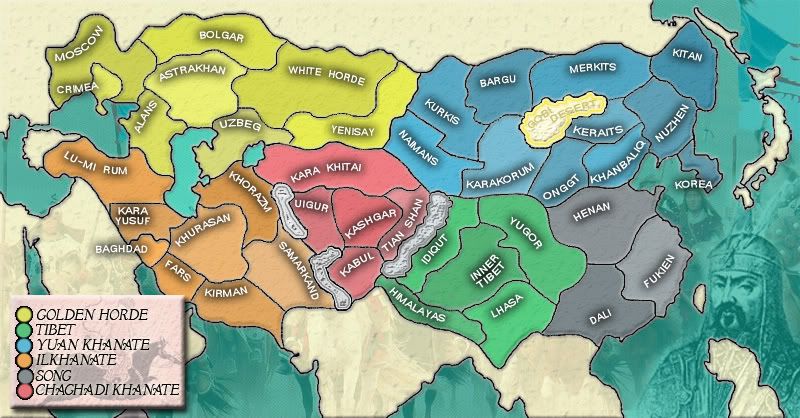
Ok update time: all country names have been added, as have impassable borders and sea routes from crimea and from fukien.
Now do the bonus need to be adjusted?
Also, I've noticed that the number of territories is 37 - 36 would be better so which territory should i merge / lose? I was thinkin of Crimea, or maybe fars and kirman
great work with the map so far
i don't think you should take away crimea, maybe take one from yuan khanate
as for the sea routes i think you have too many borders even without them, and as said they were not famous for their ships
i think you need more impassable borders, you should get the great wall in there and there are mountains all over the area, you could use kashmir and the caucasus
i think you should change the names of inner and outer tibet, you could for example use Lhasa for outer tibet after a town in the area. you could also change the shape of the territory himalayas so that it looks more like a mountain ridge
an other name that could be changed i siberia, that doesn't look like siberia to me, you could use kazan or bolgar instead
keep up the good work
-
Lone.prophet
- Posts: 1467
- Joined: Thu Oct 12, 2006 4:37 pm
- Location: Your basement Muahaha

-
edmundomcpot

- Posts: 464
- Joined: Tue Aug 29, 2006 10:18 am
- Location: N.wales
- Contact:
-
Nous-irons
- Posts: 110
- Joined: Sun Oct 01, 2006 4:33 pm
-
Guiscard
- Posts: 4103
- Joined: Fri Dec 08, 2006 7:27 pm
- Location: In the bar... With my head on the bar
Thanks for the comments guys.
Have added 3 territories: Korea, Badhdad and Uigur to take he number up to a more playable 40.
Qwert: I am going on more detailed sources than wikipedia, and this is the best 'average' i can get for the extent of mongol territory in the mid 13th century. It did cover more territory at some points but this was either temporary, tributary nations or conquests which came much later (e.g. india).
Have changed siberia to bolgar and outer tibet to lhasa, thanks glee.
Also added more impassable borders.
-
Lone.prophet
- Posts: 1467
- Joined: Thu Oct 12, 2006 4:37 pm
- Location: Your basement Muahaha
-
Guiscard
- Posts: 4103
- Joined: Fri Dec 08, 2006 7:27 pm
- Location: In the bar... With my head on the bar
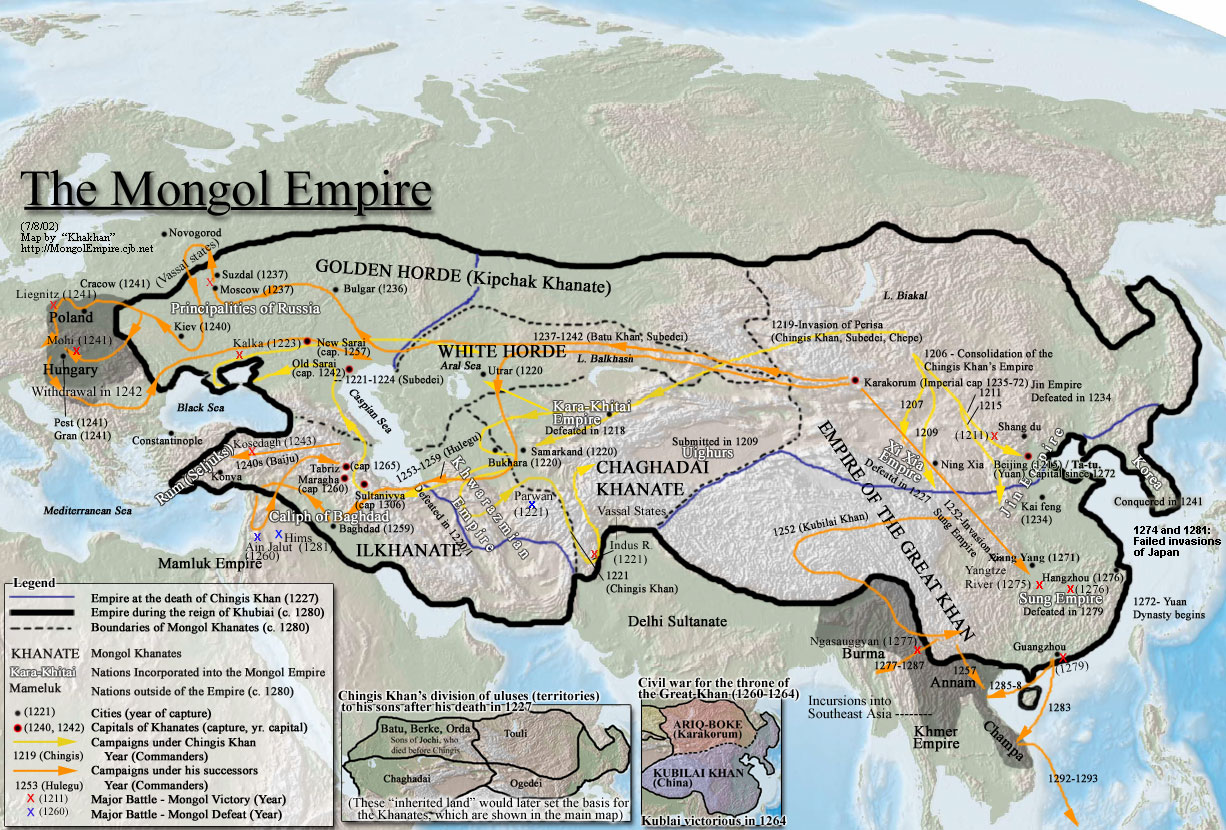
If you look at this map (although I am going from two better historical atlas available through the wonders of a university library) you can see that my map pretty much covers the extent of monol territory. The mongols were only in poland / hungary for a year and this was before the establishment of the ilkhanate and the capture of bahgdad and the consolidation of china under the yuan dynasty. Including Europe would mean taking away various parts of china and central asia. The only territory I have discovered that I have not included is syria, which was conquered in 1258.
In regards to the font on the legend, sure that can certainly be changed but I was quite happy with it. What do other people think? And what kind of font should it be changed to if it needs changing? A more 'archaic' style or a simple plain font to match the territory names?
edit: forgot the map link: http://www.allempires.com/empires/mongol/mongolempire_map.jpg