
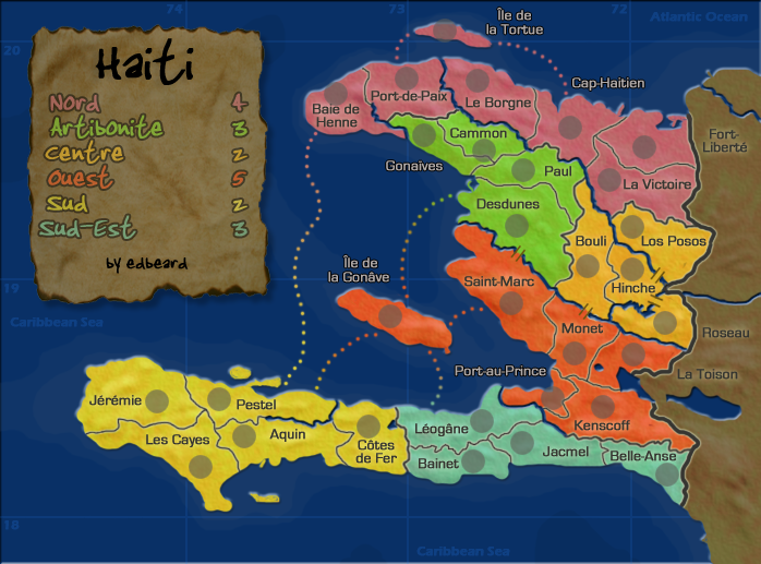
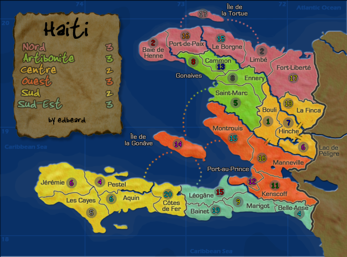
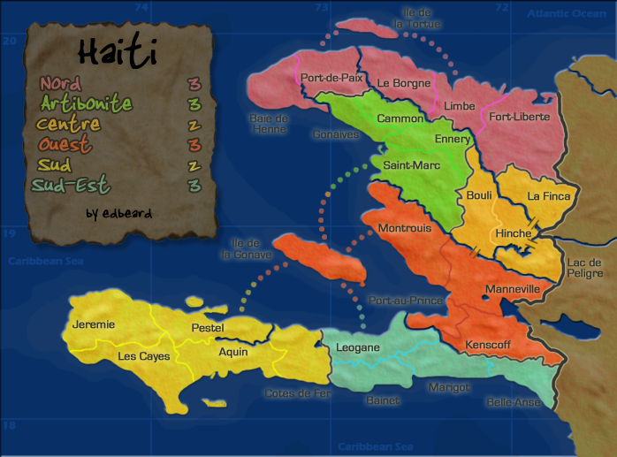
[bigimg]http://i140.photobucket.com/albums/r4/runthemover/haitiv11.png[/bigimg]
What you need to know:
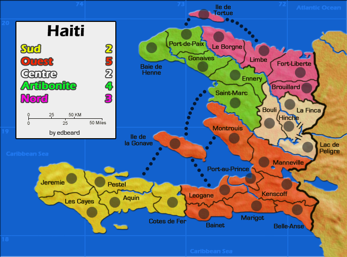
1. 30 territories
2. 6 continents
Changes in this update
1. added two territories. one in Nord and one in Ouest upping the total count to 30
2. changed a bunch of names. I found a different map of the country and changed some names to major cities.
To Do:
1. redo small in same way as large
2. change XML names to match new territory names and change centering since a few circles moved.
Points of Discussion
1. New gameplay - do the bonuses work now that larger bonuses require more territories
Haiti [Quenched]
Moderator: Cartographers
Forum rules
Please read the Community Guidelines before posting.
Please read the Community Guidelines before posting.
-
AndyDufresne

- Posts: 24935
- Joined: Fri Mar 03, 2006 8:22 pm
- Location: A Banana Palm in Zihuatanejo
- Contact:
Re: Haiti v11 pg11
I think you are on the right track regarding the bonuses now. Sud feels a little odd, but I understand the reasoning as it only has two borders.
On a graphics note, what if you used the same gray stroke (or perhaps slightly darker) as the color for the title and your sig, rather than the black?
--Andy
On a graphics note, what if you used the same gray stroke (or perhaps slightly darker) as the color for the title and your sig, rather than the black?
--Andy
Re: Haiti v11 pg11
AndyDufresne wrote:I think you are on the right track regarding the bonuses now. Sud feels a little odd, but I understand the reasoning as it only has two borders.
I could take Cotes de Fer and put that with Sud-est. It's totally not part of that area in real life but I've made a lot of other alterations too. This is about making a map not a real representation of these zones.
That'd make sud a 4 territory 2 border +2
That'd make sud-est a 5 territory 4 border continent...+4 now? Even though it can be made into a 3 border continent by taking Kenscoff? Only problem is it gives the south a +11 vs the +9 for the north. 4 borders vs 3 borders though (south v north)
AndyDufresne wrote:On a graphics note, what if you used the same gray stroke (or perhaps slightly darker) as the color for the title and your sig, rather than the black?
--Andy
I'll try that. thanks
-
AndyDufresne
- Posts: 24935
- Joined: Fri Mar 03, 2006 8:22 pm
- Location: A Banana Palm in Zihuatanejo
- Contact:
Re: Haiti v11 pg11
edbeard wrote:That'd make sud-est a 5 territory 4 border continent...+4 now? Even though it can be made into a 3 border continent by taking Kenscoff?
The idea you have proposed is interesting. I could see you making Sud-est that. Take a look at it this way...It'd give you a +4 in the North, and another +4 in the South. And in such a small map, I think this would help balance out a Strong North and a slightly Weaker South...
--Andy

Re: Haiti v11 pg11
edbeard wrote:I could take Cotes de Fer and put that with Sud-est. It's totally not part of that area in real life but I've made a lot of other alterations too. This is about making a map not a real representation of these zones.
That'd make sud a 4 territory 2 border +2
That'd make sud-est a 5 territory 4 border continent...+4 now?
Hmm.. crap... if you could knock it down to three borders it would be a perfect +3. What if the attack route from the Ile was moved from Leogane to Port-au-Prince: this would protect leogane and give the Ouest region another internal attack route, which it could use.
My only other thought on this map is that the rivers are a bit tight in some places, and will just get thinner in the small version. Maybe widen some a pixel to make the impassables clear?
Re: Haiti v11 pg11
oaktown wrote:edbeard wrote:I could take Cotes de Fer and put that with Sud-est. It's totally not part of that area in real life but I've made a lot of other alterations too. This is about making a map not a real representation of these zones.
That'd make sud a 4 territory 2 border +2
That'd make sud-est a 5 territory 4 border continent...+4 now?
Hmm.. crap... if you could knock it down to three borders it would be a perfect +3. What if the attack route from the Ile was moved from Leogane to Port-au-Prince: this would protect leogane and give the Ouest region another internal attack route, which it could use.
My only other thought on this map is that the rivers are a bit tight in some places, and will just get thinner in the small version. Maybe widen some a pixel to make the impassables clear?
I don't think there'll be confusion about the rivers. There's a glow around the borders which distinguishes them from the river, and the border lines get smaller with the smaller map too! The proportion remains the same. Wait until the small version comes around again.
As for the Leogane route...my only problem with that is that it makes it possible to hold sud-est with just two borders. Though you need to hold six territories. I'll think about this a bit more. The Port-au-Prince route is a good idea. It is a port after all and it does open up that area a bit. The only problem is the name will cover the route a bit. Your idea is a good one with respect to balancing north and south. I'd rather not have 5 4 2 there and 4 3 2 in the north. My only question is...does taking away that route to Leogane make Ouest into a +4 region?
Re: Haiti v11 pg11
edbeard wrote:I don't think there'll be confusion about the rivers. There's a glow around the borders which distinguishes them from the river, and the border lines get smaller with the smaller map too! The proportion remains the same. Wait until the small version comes around again.
Fair enough... I trust you.
edbeard wrote:As for the Leogane route...my only problem with that is that it makes it possible to hold sud-est with just two borders. Though you need to hold six territories. I'll think about this a bit more.
So it's a five territory, +3 region with three borders, which expands to a six territory, +3 region with two borders... I think both configurations are solid.
edbeard wrote:The Port-au-Prince route is a good idea. It is a port after all and it does open up that area a bit. The only problem is the name will cover the route a bit.
As long as the dot layer is under the title I think you're cool.
edbeard wrote:does taking away that route to Leogane make Ouest into a +4 region?
I don't think so - it still has as many territories to defend, and by adding an internal route you are actually making the region harder to conquer in the first place because you can't evacuate your armies out of any territory until you have the entire thing.
Another thing - do you think you can fit the Fort Liberte title in the territory? It looks like there's space, and the less you have floating in the dead area the better.
Re: Haiti v11 pg11
oaktown wrote:edbeard wrote:does taking away that route to Leogane make Ouest into a +4 region?
I don't think so - it still has as many territories to defend, and by adding an internal route you are actually making the region harder to conquer in the first place because you can't evacuate your armies out of any territory until you have the entire thing.
well that depends on what strategy you use to conquer a region but definitely a good point. I'd like to hear more people chime in because it's definitely a key point. Another reason for +5 is the fact that it contains 3/4 routes to go from North to South.
Another qualm I have about taking out the Leogane route is that it takes away from the movement in that area. But, maybe it's a good thing that you can't go directly there.
oaktown wrote:Another thing - do you think you can fit the Fort Liberte title in the territory? It looks like there's space, and the less you have floating in the dead area the better.
definitely in the large. the small I don't know because the text is larger on the small and the army circle remains the same size (proportionally larger). I'd rather keep them in the same spot in this instance. I agree it does look a bit weird
-
gimil

- Posts: 8599
- Joined: Sat Mar 03, 2007 12:42 pm
- Gender: Male
- Location: United Kingdom (Scotland)
Re: Haiti v11 pg11
Edbeard for the sake of consistancy would you consider testing all terr names in white with the black stroke? I suspect this will feel a little better than the current terr colours on the map.
What do you know about map making, bitch?
Top Score:2403
natty_dread wrote:I was wrong
Top Score:2403
Re: Haiti v11 pg11
gimil wrote:Edbeard for the sake of consistancy would you consider testing all terr names in white with the black stroke? I suspect this will feel a little better than the current terr colours on the map.
do you mean the grey / silver that I use on the water? if so, I've already tried that on the whole map and it looks weird.
If you actually mean white then I'll try that on this go. though I tried that a long time ago on this map. I don't remember why I didn't keep it but I'll look again.
-
gimil
- Posts: 8599
- Joined: Sat Mar 03, 2007 12:42 pm
- Gender: Male
- Location: United Kingdom (Scotland)
Re: Haiti v11 pg11
We going to see an update anytime soon?
What do you know about map making, bitch?
Top Score:2403
natty_dread wrote:I was wrong
Top Score:2403
Re: Haiti v11 pg11
gimil wrote:We going to see an update anytime soon?
relatively soon. yes.
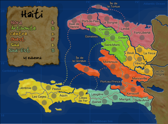
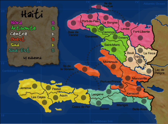
Re: Haiti v12 pg11
[bigimg]http://i140.photobucket.com/albums/r4/runthemover/haitiv12.png[/bigimg]
http://i140.photobucket.com/albums/r4/runthemover/haitiv11.png
http://i140.photobucket.com/albums/r4/runthemover/haitiv10.png
http://i140.photobucket.com/albums/r4/runthemover/haitismallv3.png
http://i140.photobucket.com/albums/r4/runthemover/haitiv9-1.png
http://i140.photobucket.com/albums/r4/runthemover/haitivxml2.png
http://i140.photobucket.com/albums/r4/runthemover/haitismallv2-1.png
http://i140.photobucket.com/albums/r4/runthemover/haitismallv2a.png
http://i140.photobucket.com/albums/r4/runthemover/haitismallvxml2.png
v8
v7
v6
v5
v4
v3
v2
v1
What you need to know:
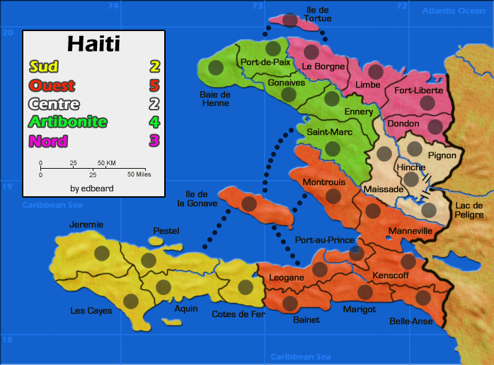
1. 30 territories
2. 6 continents
Changes in this update
1. continent changes: added Cotes de Fer territory to the Sud Est continent
2. removed the route from Leogane to Ile de la Gonave
3. added route to Port au Prince
4. changed a couple of existing water routes to match the style of the rest
To Do:
1. redo small in same way as large
2. change XML names to match new territory names and change centering since a few circles moved.
Points of Discussion
1. gameplay good?
2. things I didn't do:
a. Andy asked me try out a different title and sig. I tried a grey but it looked bad. I tried a glow with no success either. I decided to blend them a bit more which seemed fine to me. It wasn't a huge change but I didn't have a problem with it before.
b. gimil asked me to try out a uniform text. I'd tried this before with no success. I tried out white text with a black stroke and using the water text all around but nothing looked good to me. I'm fine with what I have currently so I think that issue is closed.
http://i140.photobucket.com/albums/r4/runthemover/haitiv11.png
http://i140.photobucket.com/albums/r4/runthemover/haitiv10.png
http://i140.photobucket.com/albums/r4/runthemover/haitismallv3.png
http://i140.photobucket.com/albums/r4/runthemover/haitiv9-1.png
http://i140.photobucket.com/albums/r4/runthemover/haitivxml2.png
http://i140.photobucket.com/albums/r4/runthemover/haitismallv2-1.png
http://i140.photobucket.com/albums/r4/runthemover/haitismallv2a.png
http://i140.photobucket.com/albums/r4/runthemover/haitismallvxml2.png
v8
v7
v6
v5
v4
v3
v2
v1
What you need to know:
1. 30 territories
2. 6 continents
Changes in this update
1. continent changes: added Cotes de Fer territory to the Sud Est continent
2. removed the route from Leogane to Ile de la Gonave
3. added route to Port au Prince
4. changed a couple of existing water routes to match the style of the rest
To Do:
1. redo small in same way as large
2. change XML names to match new territory names and change centering since a few circles moved.
Points of Discussion
1. gameplay good?
2. things I didn't do:
a. Andy asked me try out a different title and sig. I tried a grey but it looked bad. I tried a glow with no success either. I decided to blend them a bit more which seemed fine to me. It wasn't a huge change but I didn't have a problem with it before.
b. gimil asked me to try out a uniform text. I'd tried this before with no success. I tried out white text with a black stroke and using the water text all around but nothing looked good to me. I'm fine with what I have currently so I think that issue is closed.
Re: Haiti v12 pg11
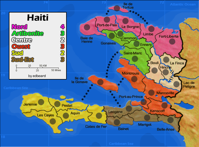
hey ed, I like Sud-est - the bonus seems right on. And by removing the route to Ile, it can be held with two borders and six territories, which is also fair for a +3.
Little things:
•Is that little island in the south really flat on the bottom like that?
• Especially on the small map, it might not hurt to play around with the area that Desdunes, Paul, and Gonaives come together, as Desdunes and Gonaivesa are pretty close.
• weren't you hoping to make the north and south even in terms of bonus and borders, assuming games could end up as a two-sided north/south stand off? Because I'm still raising my eyebrows at the fact that Ouest is six terits with 4 borders for +5, while Nord is seven terits with 4 borders for +4. Seems like you could make them the same (either 4 or 5) and the total top/bottom bonuses would be the same. I get that the north has one less border, but it does have to defend positions in all three regions while the south has Sud-Est safely tucked away. I also get that Nord will be pretty easy to conquer, since it's very linear.
Just a thought... if folks disagree with me I'm prepared to stamp it.
And i don't mind the text not having a uniform color, but what bugs me is that the color over the seas looks crisper than that on the land - the stroke perhaps does that?
Re: Haiti v12 pg11
oaktown wrote:•Is that little island in the south really flat on the bottom like that?
yea. it has a slight curve which I neglected to put in there apparently.
oaktown wrote:• Especially on the small map, it might not hurt to play around with the area that Desdunes, Paul, and Gonaives come together, as Desdunes and Gonaivesa are pretty close.
will do
oaktown wrote:• weren't you hoping to make the north and south even in terms of bonus and borders, assuming games could end up as a two-sided north/south stand off? Because I'm still raising my eyebrows at the fact that Ouest is six terits with 4 borders for +5, while Nord is seven terits with 4 borders for +4. Seems like you could make them the same (either 4 or 5) and the total top/bottom bonuses would be the same. I get that the north has one less border, but it does have to defend positions in all three regions while the south has Sud-Est safely tucked away. I also get that Nord will be pretty easy to conquer, since it's very linear.
I was hoping that but as you said, you can hold the entire north with three territories and the south needs you to hold four (unless you take over Desdunes). Ouest is the way to get from north to south. it has three of the four routes. This makes it a somewhat 'central' regions that could get a bit of traffic. Ouest also borders all the same continents as Nord plus another one. I'm not averse to changing it but I guess i need a strong argument. I just don't see one at the moment.
oaktown wrote:And i don't mind the text not having a uniform color, but what bugs me is that the color over the seas looks crisper than that on the land - the stroke perhaps does that?
it does do that but to me it looks fine. It's readable everywhere which is the most important part.
Re: Haiti v12 pg11
edbeard wrote:oaktown wrote:And i don't mind the text not having a uniform color, but what bugs me is that the color over the seas looks crisper than that on the land - the stroke perhaps does that?
it does do that but to me it looks fine. It's readable everywhere which is the most important part.
Looks to me as if you've stroked the text over the water, but put a glow on the text over the land... what if you made them all stroked,but kept the current colors (dark stroke over water text, light stroke over land text)? I think that would better tie them together visually without making the colors the same, which I would not push for.
-
gimil
- Posts: 8599
- Joined: Sat Mar 03, 2007 12:42 pm
- Gender: Male
- Location: United Kingdom (Scotland)
Re: Haiti v12 pg11
Thought you would need to know:
http://news.bbc.co.uk/1/hi/world/americas/7581669.stm
http://news.bbc.co.uk/1/hi/world/americas/7581669.stm
What do you know about map making, bitch?
Top Score:2403
natty_dread wrote:I was wrong
Top Score:2403
Re: Haiti v12 pg11
since nobody other than I has expressed any concern with the current bonuses...

Re: Haiti v12 pg11
oaktown wrote:since nobody other than I has expressed any concern with the current bonuses...
sounds good. I tried out various forms of texts for the land but nothing satisfied me. Since I like the text as it is, I'm going to leave it be. Next update will be large and small versions to (hopefully) get a graphics stamp.
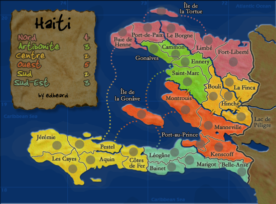
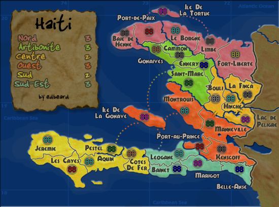
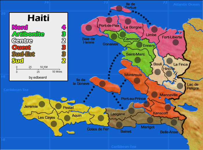
Re: Haiti v13 pg12
[bigimg]http://i140.photobucket.com/albums/r4/runthemover/haitiv15.png[/bigimg]
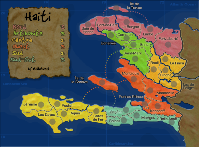
[bigimg]http://i140.photobucket.com/albums/r4/runthemover/haitismallv6.png[/bigimg]
http://i140.photobucket.com/albums/r4/runthemover/haitiv12.png
http://i140.photobucket.com/albums/r4/runthemover/haitiv11.png
http://i140.photobucket.com/albums/r4/runthemover/haitiv10.png
http://i140.photobucket.com/albums/r4/runthemover/haitismallv3.png
http://i140.photobucket.com/albums/r4/runthemover/haitiv9-1.png
http://i140.photobucket.com/albums/r4/runthemover/haitivxml2.png
http://i140.photobucket.com/albums/r4/runthemover/haitismallv2-1.png
http://i140.photobucket.com/albums/r4/runthemover/haitismallv2a.png
http://i140.photobucket.com/albums/r4/runthemover/haitismallvxml2.png
v8
v7
v6
v5
v4
v3
v2
v1
What you need to know:
1. 30 territories
2. 6 continents
Changes in this update
1. did some shit. now we've got both small and large
To Do:
1. change up XML names to match changes I've made. finish up centering based on circle movements
Points of Discussion
1. graphics. good for stamp? damn right it is.
Last edited by edbeard on Wed Oct 01, 2008 10:29 pm, edited 2 times in total.

Re: Haiti v13 pg12
edbeard wrote:....
1. graphics. good for stamp? damn right it is.
Yes i agree, but can you look at these small nit-picks please...yes i've put the map under the microscope, and i hope you won't mind.
But it's looking great.


* Pearl Harbour * Waterloo * Forbidden City * Jamaica * Pot Mosbi
Re: Haiti v13 pg12 [i][gp]
thanks cairnswk
I'll fix the Bouli - Desdunes border
the rest of the borders are fine. people will be able to tell the difference between thicker river borders and thinner territory and continent borders which have a light stroke around them. thanks though!
edit: fixed that border. if you don't see it then refresh that browser (I think that's the first time I've been able to say that to you cairnswk)

Re: Haiti v13 pg12 [i][gp]
edbeard wrote:the rest of the borders are fine. people will be able to tell the difference between thicker river borders and thinner territory and continent borders which have a light stroke around them. thanks though!
Agree - they're different colours to make them nicer on the eye - dependant on the continent colour.
C.

Highest score : 2297
-
gimil
- Posts: 8599
- Joined: Sat Mar 03, 2007 12:42 pm
- Gender: Male
- Location: United Kingdom (Scotland)
Re: Haiti v13 pg12 [i][gp]
So were just nit picking here? Ed you earned this:

What do you know about map making, bitch?
Top Score:2403
natty_dread wrote:I was wrong
Top Score:2403
Re: Haiti v13 pg12 [i][gp]
sweeeeet. thanks!