[Official] British Isles REVAMP [Quenched]
Moderator: Cartographers
Forum rules
Please read the Community Guidelines before posting.
Please read the Community Guidelines before posting.

Re: [Official] British Isles REVAMP - P1+39[I, GP] [Final Forge]
One small nitpick: the compass in the large version looks a bit blurry. Could you sharpen it a bit?
 Other than that, great job!

Re: [Official] British Isles REVAMP - P1+39[I, GP] [Final Forge]
I cant really see anything wrong other than that the triples touch on the small map in Cumberland and Westmoreland...but really thats not a problem.
QUENCH.
QUENCH.

-
gimil

- Posts: 8599
- Joined: Sat Mar 03, 2007 12:42 pm
- Gender: Male
- Location: United Kingdom (Scotland)
Re: [Official] British Isles REVAMP - P1+39[I, GP] [Final Forge]
The large compass required a little touch of blur or it looked out of place on the large map 
What do you know about map making, bitch?
Top Score:2403
natty_dread wrote:I was wrong
Top Score:2403
Re: [Official] British Isles REVAMP - P1+39[I, GP] [Final Forge]
Oh, okay. In that case, quench!

Re: [Official] British Isles REVAMP - P1+39[I, GP] [Final Forge]
Just a thought - it's only a minor thing, but could 'Midlands' be renamed 'East Midlands'?
Re: [Official] British Isles REVAMP - P1+39[I, GP] [Final Forge]
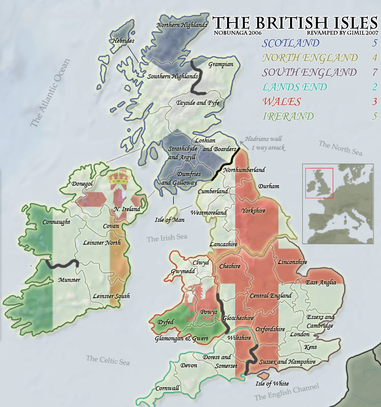
There are severl spelling errors:
Glamongan and Gwert should be Glamorgan and Gwent
Irerand should be Ireland
Donset should be Dorset
Essexs should be Essex.
There may be others too. You should check it carefully .
Glamongan and Gwert should be Glamorgan and Gwent
Irerand should be Ireland
Donset should be Dorset
Essexs should be Essex.
There may be others too. You should check it carefully .
Re: [Official] British Isles REVAMP - P1+39[I, GP] [Final Forge]
There are a few more spellings which require changing
Covan shold be Cavan
Donegol should be Donegal
Linconshire should be Lincolnshire
Gloucestershire is the correct spelling
Isle of White should be Isle of Wight
Dorest should be Dorset.
Hope this is helpful.
Covan shold be Cavan
Donegol should be Donegal
Linconshire should be Lincolnshire
Gloucestershire is the correct spelling
Isle of White should be Isle of Wight
Dorest should be Dorset.
Hope this is helpful.
Re: [Official] British Isles REVAMP - P1+39[I, GP] [Final Forge]
In the XML you need to make the following changes:
'Essex & Cambridge' needs to be changed to 'Essex & Cambridgeshire'
'Gloucester' needs to be 'Gloucestershire'
<name>Connaught</name>
<borders>
<border>Borders</border> --- This should be "Border Counties"
<name>London</name>
<borders>
<border>Essex</border> --- This should be "Essex & Cambridgeshire" (you've done this in a couple of places)
Re: [Official] British Isles REVAMP - P1+39[I, GP] [Final Forge]
MrBenn wrote:'Gloucester' needs to be 'Gloucestershire'
That change also needs to be made in the bottom left corner of the map, where the abbreviations are explained.

Re: [Official] British Isles REVAMP - P1+39[I, GP] [Final Forge]
any chance at you having another go at the wall?
it just seems a bit underdone at the moment. A few more subtle details might push it over the edge
it just seems a bit underdone at the moment. A few more subtle details might push it over the edge
-
Ruben Cassar

- Posts: 2160
- Joined: Thu Nov 16, 2006 6:04 am
- Gender: Male
- Location: Civitas Invicta, Melita, Evropa
Re: [Official] British Isles REVAMP - P1+38[I, GP] [Final Forge]
MrBenn wrote:How about adding a tag to the current map in play to let people know that it is about to be revamped:
[bigimg]http://www.twogoodpaws.co.uk/conquerclub/britrev.png[/bigimg]
An excellent idea that has been totally ignored. I'm bringing it up again. This should become the de facto standard for every map that is being revamped. It would definitely avoid us the problems created by Classic.
I don't think that British Isles will be a problem because the new version is much more superior to the old one, but it helps to let people who do not visit the foundry know that a revamp is in progress. This might even add more input to the foundry process.


-
gimil
- Posts: 8599
- Joined: Sat Mar 03, 2007 12:42 pm
- Gender: Male
- Location: United Kingdom (Scotland)
Re: [Official] British Isles REVAMP - P1+38[I, GP] [Final Forge]
Ruben Cassar wrote:An excellent idea that has been totally ignored. I'm bringing it up again.
Thats a little harsh. If you had read the full thread you would of known that oaktown already brought attention to it backstage
What do you know about map making, bitch?
Top Score:2403
natty_dread wrote:I was wrong
Top Score:2403
-
Ruben Cassar
- Posts: 2160
- Joined: Thu Nov 16, 2006 6:04 am
- Gender: Male
- Location: Civitas Invicta, Melita, Evropa
Re: [Official] British Isles REVAMP - P1+38[I, GP] [Final Forge]
gimil wrote:Ruben Cassar wrote:An excellent idea that has been totally ignored. I'm bringing it up again.
Thats a little harsh. If you had read the full thread you would of known that oaktown already brought attention to it backstage
Ouch my fault then I did not read all the thread.
Still it's a good idea.
-
gimil
- Posts: 8599
- Joined: Sat Mar 03, 2007 12:42 pm
- Gender: Male
- Location: United Kingdom (Scotland)
Re: [Official] British Isles REVAMP - P1+38[I, GP] [Final Forge]
Ruben Cassar wrote:gimil wrote:Ruben Cassar wrote:An excellent idea that has been totally ignored. I'm bringing it up again.
Thats a little harsh. If you had read the full thread you would of known that oaktown already brought attention to it backstage
Ouch my fault then I did not read all the thread.
Still it's a good idea.
We may have a better one in the works
But back on topic theres a thread elsewhere for this to be discussed.
What do you know about map making, bitch?
Top Score:2403
natty_dread wrote:I was wrong
Top Score:2403
-
Ray Rider

- Posts: 422
- Joined: Sat Oct 27, 2007 9:21 pm
- Gender: Male
- Location: In front of my computer, duh!
Re: [Official] British Isles REVAMP - P1+38[I, GP] [Final Forge]
Ruben Cassar wrote:MrBenn wrote:How about adding a tag to the current map in play to let people know that it is about to be revamped:
[bigimg]http://www.twogoodpaws.co.uk/conquerclub/britrev.png[/bigimg]
An excellent idea that has been totally ignored. I'm bringing it up again. This should become the de facto standard for every map that is being revamped. It would definitely avoid us the problems created by Classic.
I don't think that British Isles will be a problem because the new version is much more superior to the old one, but it helps to let people who do not visit the foundry know that a revamp is in progress. This might even add more input to the foundry process.
I agree--that's a great idea.
I've played on the old British Isles map quite a bit, and I just want to let you guys know that this new map looks great
I'd say this one looks even better. Why not use it? Sorry if it's a stupid question, but I haven't been in the map foundry very much.gimil wrote:


Highest score: 2221

Re: [Official] British Isles REVAMP - P1+39[I, GP] [Final Forge]
Alot of people have brought up the fact that wall looks like a pile of C***. Could you please work on this? The wall on the old map looks mych better than the present one!
Ps...Northern Ireland is not part of Ireland
Ps...Northern Ireland is not part of Ireland
[img]http://img801.imageshack.us/img801/9761/41922610151374166770386.jpg[/mg]
-
CaptainMoo

- Posts: 340
- Joined: Mon Dec 18, 2006 2:17 pm
- Gender: Male
- Location: Edinburgh
- Contact:
Re: [Official] British Isles REVAMP - P1+39[I, GP] [Final Forge]
please dont f*ck up this map like you did on the original
why do u guys keep ruining the flagship maps of this site......if you think its a super new map then release a 2nd version and let people have the choice.......over designing and constant re-thinking are destroying the playability and fun on this sites best maps.
if it aint broke then leave it the f*ck alone.....
apologies for language but after the orginal map was destroyed its been highlighted we have to scour the foundry for future crap and post opinion before its enforced
LEAVE IT ALONE FFS PLEASE
http://www.moo-directory.com
Is your website listed yet?
Free, Reciprocal and Strong One Way Links.
Part of the http://www.cozy-digital.co.uk Group
Is your website listed yet?
Free, Reciprocal and Strong One Way Links.
Part of the http://www.cozy-digital.co.uk Group

Re: [Official] British Isles REVAMP - P1+39[I, GP] [Final Forge]
CaptainMoo wrote:please dont f*ck up this map like you did on the original
why do u guys keep ruining the flagship maps of this site......if you think its a super new map then release a 2nd version and let people have the choice.......over designing and constant re-thinking are destroying the playability and fun on this sites best maps.
if it aint broke then leave it the f*ck alone.....
apologies for language but after the orginal map was destroyed its been highlighted we have to scour the foundry for future crap and post opinion before its enforced
LEAVE IT ALONE FFS PLEASE
I have to disagree - the current "British Isles" map IS broken... have you seen some of the names of places?
Also - the style is very out of date and quick rough - look at that horrid texture running through the middle of it!
I think Gimil has done a very good job cleaning this map up and fixing most of the goegraphical inconsistencies.
C.

Highest score : 2297
-
gimil
- Posts: 8599
- Joined: Sat Mar 03, 2007 12:42 pm
- Gender: Male
- Location: United Kingdom (Scotland)
Re: [Official] British Isles REVAMP - P1+39[I, GP] [Final Forge]
And its becasue of people PM the origonal artist and saying the graphics were crap and tehy wanted a revamp that this i shappening.
The choices on the table are it gets revamped or the BI artists takes teh map from the site
The choices on the table are it gets revamped or the BI artists takes teh map from the site
What do you know about map making, bitch?
Top Score:2403
natty_dread wrote:I was wrong
Top Score:2403

Re: [Official] British Isles REVAMP - P1+39[I, GP] [Final Forge]
CaptainMoo wrote:please dont f*ck up this map like you did on the original
why do u guys keep ruining the flagship maps of this site......if you think its a super new map then release a 2nd version and let people have the choice.......over designing and constant re-thinking are destroying the playability and fun on this sites best maps.
if it aint broke then leave it the f*ck alone.....
apologies for language but after the orginal map was destroyed its been highlighted we have to scour the foundry for future crap and post opinion before its enforced
LEAVE IT ALONE FFS PLEASE
maybe you should have less of the attitude eh?
gimil didnt revamp the classic map, he just posted the drafts on a thread, wasnt it something like the guy didnt want to be named or known or something,
so dont take that out on gimil,
revamps are for making things better, so if you have an option for something better you'd take it,
now enough thread jacking and back to the map
--
i think that the map just lacks in colour is all, the sea looks white and the green stoke on the cornish bit looks weird to me
Re: [Official] British Isles REVAMP - P1+39[I, GP] [Final Forge]
CaptainMoo wrote:please dont f*ck up this map like you did on the original
why do u guys keep ruining the flagship maps of this site......if you think its a super new map then release a 2nd version and let people have the choice.......over designing and constant re-thinking are destroying the playability and fun on this sites best maps.
if it aint broke then leave it the f*ck alone.....
apologies for language but after the orginal map was destroyed its been highlighted we have to scour the foundry for future crap and post opinion before its enforced
LEAVE IT ALONE FFS PLEASE
i say we ban u for flaming gimil

Re: [Official] British Isles REVAMP - P1+39[I, GP] [Final Forge]
This is alot better than the old one, but it is lacking something. Nothing really pops out to me to play this board. Do you know what I mean? Ether way it does look nice.
"ENJOY THE GAME"
-
gimil
- Posts: 8599
- Joined: Sat Mar 03, 2007 12:42 pm
- Gender: Male
- Location: United Kingdom (Scotland)
Re: [Official] British Isles REVAMP - P1+39[I, GP] [Final Forge]
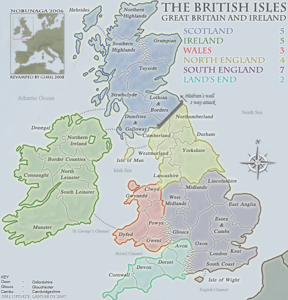
[bigimg]http://i25.photobucket.com/albums/c64/Gimil_01/TheBritishIslesLARGE-7.png[/bigimg]
Code: Select all
<?xml version="1.0" ?>
<map>
<title>British Isles</title>
<smallwidth>577</smallwidth>
<smallheight>600</smallheight>
<largewidth>750</largewidth>
<largeheight>780</largeheight>
<filetype>png</filetype>
<continent>
<name>Scotland</name>
<bonus>5</bonus>
<components>
<component>Lothian & Borders</component>
<component>Dumfries & Galloway</component>
<component>Grampian</component>
<component>Hebrides</component>
<component>Northern Highlands</component>
<component>Southern Highlands</component>
<component>Strathclyde</component>
<component>Tayside</component>
</components>
</continent>
<continent>
<name>Ireland</name>
<bonus>5</bonus>
<components>
<component>Munster</component>
<component>South Leinster</component>
<component>North Leinster</component>
<component>Connaught</component>
<component>Border Counties</component>
<component>Northern Ireland</component>
<component>Donegal</component>
</components>
</continent>
<continent>
<name>Wales</name>
<bonus>3</bonus>
<components>
<component>Clwyd</component>
<component>Dyfed</component>
<component>Gwent</component>
<component>Gwynedd</component>
<component>Powys</component>
</components>
</continent>
<continent>
<name>North England</name>
<bonus>4</bonus>
<components>
<component>Cumberland</component>
<component>Durham</component>
<component>Isle Of Man</component>
<component>Lancashire</component>
<component>Northumberland</component>
<component>Westmorland</component>
<component>Yorkshire</component>
</components>
</continent>
<continent>
<name>South England</name>
<bonus>7</bonus>
<components>
<component>West Midlands</component>
<component>Midlands</component>
<component>Lincolnshire</component>
<component>Oxfordshire</component>
<component>Essex & Cambridgeshire</component>
<component>East Anglia</component>
<component>South Coast</component>
<component>London</component>
<component>Kent</component>
<component>Isle of Wight</component>
<component>Glouchester</component>
</components>
</continent>
<continent>
<name>Land's End</name>
<bonus>2</bonus>
<components>
<component>Cornwall</component>
<component>Devon</component>
<component>Dorset</component>
<component>Avon</component>
</components>
</continent>
<territory>
<name>Lothian & Borders</name>
<borders>
<border>Dumfries & Galloway</border>
<border>Strathclyde</border>
<border>Tayside</border>
</borders>
<coordinates>
<smallx>337</smallx>
<smally>230</smally>
<largex>436</largex>
<largey>293</largey>
</coordinates>
</territory>
<territory>
<name>Dumfries & Galloway</name>
<borders>
<border>Lothian & Borders</border>
<border>Isle Of Man</border>
<border>Strathclyde</border>
<border>Northern Ireland</border>
</borders>
<coordinates>
<smallx>297</smallx>
<smally>266</smally>
<largex>387</largex>
<largey>339</largey>
</coordinates>
</territory>
<territory>
<name>Grampian</name>
<borders>
<border>Tayside</border>
</borders>
<coordinates>
<smallx>322</smallx>
<smally>126</smally>
<largex>420</largex>
<largey>157</largey>
</coordinates>
</territory>
<territory>
<name>Hebrides</name>
<borders>
<border>Southern Highlands</border>
</borders>
<coordinates>
<smallx>178</smallx>
<smally>61</smally>
<largex>231</largex>
<largey>75</largey>
</coordinates>
</territory>
<territory>
<name>Northern Highlands</name>
<borders>
<border>Southern Highlands</border>
</borders>
<coordinates>
<smallx>249</smallx>
<smally>79</smally>
<largex>329</largex>
<largey>90</largey>
</coordinates>
</territory>
<territory>
<name>Southern Highlands</name>
<borders>
<border>Hebrides</border>
<border>Northern Highlands</border>
<border>Strathclyde</border>
<border>Tayside</border>
</borders>
<coordinates>
<smallx>238</smallx>
<smally>143</smally>
<largex>314</largex>
<largey>180</largey>
</coordinates>
</territory>
<territory>
<name>Strathclyde</name>
<borders>
<border>Lothian & Borders</border>
<border>Donegal</border>
<border>Dumfries & Galloway</border>
<border>Southern Highlands</border>
<border>Tayside</border>
</borders>
<coordinates>
<smallx>271</smallx>
<smally>231</smally>
<largex>353</largex>
<largey>294</largey>
</coordinates>
</territory>
<territory>
<name>Tayside</name>
<borders>
<border>Lothian & Borders</border>
<border>Grampian</border>
<border>Southern Highlands</border>
<border>Strathclyde</border>
</borders>
<coordinates>
<smallx>281</smallx>
<smally>183</smally>
<largex>369</largex>
<largey>228</largey>
</coordinates>
</territory>
<territory>
<name>South Leinster</name>
<borders>
<border>Dyfed</border>
<border>Munster</border>
<border>North Leinster</border>
</borders>
<coordinates>
<smallx>155</smallx>
<smally>438</smally>
<largex>203</largex>
<largey>563</largey>
</coordinates>
</territory>
<territory>
<name>Donegal</name>
<borders>
<border>Northern Ireland</border>
<border>Strathclyde</border>
<border>Border Counties</border>
</borders>
<coordinates>
<smallx>115</smallx>
<smally>283</smally>
<largex>148</largex>
<largey>364</largey>
</coordinates>
</territory>
<territory>
<name>Connaught</name>
<borders>
<border>Border Counties</border>
<border>North Leinster</border>
</borders>
<coordinates>
<smallx>65</smallx>
<smally>354</smally>
<largex>85</largex>
<largey>455</largey>
</coordinates>
</territory>
<territory>
<name>Northern Ireland</name>
<borders>
<border>Donegal</border>
<border>Dumfries & Galloway</border>
<border>Border Counties</border>
</borders>
<coordinates>
<smallx>171</smallx>
<smally>278</smally>
<largex>223</largex>
<largey>355</largey>
</coordinates>
</territory>
<territory>
<name>Munster</name>
<borders>
<border>South Leinster</border>
</borders>
<coordinates>
<smallx>83</smallx>
<smally>460</smally>
<largex>113</largex>
<largey>581</largey>
</coordinates>
</territory>
<territory>
<name>Border Counties</name>
<borders>
<border>Connaught</border>
<border>North Leinster</border>
<border>Donegal</border>
<border>Northern Ireland</border>
</borders>
<coordinates>
<smallx>107</smallx>
<smally>326</smally>
<largex>140</largex>
<largey>417</largey>
</coordinates>
</territory>
<territory>
<name>North Leinster</name>
<borders>
<border>South Leinster</border>
<border>Border counties</border>
<border>Connaught</border>
</borders>
<coordinates>
<smallx>169</smallx>
<smally>374</smally>
<largex>221</largex>
<largey>480</largey>
</coordinates>
</territory>
<territory>
<name>Clwyd</name>
<borders>
<border>West Midlands</border>
<border>Gwynedd</border>
<border>Lancashire</border>
<border>Powys</border>
</borders>
<coordinates>
<smallx>306</smallx>
<smally>413</smally>
<largex>399</largex>
<largey>530</largey>
</coordinates>
</territory>
<territory>
<name>Dyfed</name>
<borders>
<border>South Leinster</border>
<border>Gwent</border>
<border>Gwynedd</border>
<border>Powys</border>
</borders>
<coordinates>
<smallx>275</smallx>
<smally>483</smally>
<largex>353</largex>
<largey>621</largey>
</coordinates>
</territory>
<territory>
<name>Gwent</name>
<borders>
<border>Dyfed</border>
<border>Powys</border>
</borders>
<coordinates>
<smallx>303</smallx>
<smally>515</smally>
<largex>395</largex>
<largey>663</largey>
</coordinates>
</territory>
<territory>
<name>Gwynedd</name>
<borders>
<border>Clwyd</border>
<border>Dyfed</border>
<border>Powys</border>
</borders>
<coordinates>
<smallx>284</smallx>
<smally>428</smally>
<largex>370</largex>
<largey>550</largey>
</coordinates>
</territory>
<territory>
<name>Powys</name>
<borders>
<border>West Midlands</border>
<border>Clwyd</border>
<border>Dyfed</border>
<border>Gwent</border>
<border>Gwynedd</border>
</borders>
<coordinates>
<smallx>306</smallx>
<smally>447</smally>
<largex>401</largex>
<largey>580</largey>
</coordinates>
</territory>
<territory>
<name>Cumberland</name>
<borders>
<border>Durham</border>
<border>Dumfries & Galloway</border>
<border>Isle Of Man</border>
<border>Northumberland</border>
<border>Westmorland</border>
<border>Lothian & Borders</border>
</borders>
<coordinates>
<smallx>306</smallx>
<smally>306</smally>
<largex>398</largex>
<largey>394</largey>
</coordinates>
</territory>
<territory>
<name>Durham</name>
<borders>
<border>Cumberland</border>
<border>Northumberland</border>
<border>Westmorland</border>
<border>Yorkshire</border>
</borders>
<coordinates>
<smallx>372</smallx>
<smally>294</smally>
<largex>482</largex>
<largey>377</largey>
</coordinates>
</territory>
<territory>
<name>Isle Of Man</name>
<borders>
<border>Dumfries & Galloway</border>
<border>Cumberland</border>
</borders>
<coordinates>
<smallx>256</smallx>
<smally>326</smally>
<largex>336</largex>
<largey>415</largey>
</coordinates>
</territory>
<territory>
<name>Lancashire</name>
<borders>
<border>West Midlands</border>
<border>Clwyd</border>
<border>Midlands</border>
<border>Westmorland</border>
<border>Yorkshire</border>
</borders>
<coordinates>
<smallx>328</smallx>
<smally>358</smally>
<largex>428</largex>
<largey>458</largey>
</coordinates>
</territory>
<territory>
<name>Northumberland</name>
<borders>
<border>Lothian & Borders</border>
<border>Cumberland</border>
<border>Durham</border>
</borders>
<coordinates>
<smallx>349</smallx>
<smally>274</smally>
<largex>455</largex>
<largey>350</largey>
</coordinates>
</territory>
<territory>
<name>Westmorland</name>
<borders>
<border>Cumberland</border>
<border>Durham</border>
<border>Lancashire</border>
<border>Yorkshire</border>
</borders>
<coordinates>
<smallx>327</smallx>
<smally>316</smally>
<largex>426</largex>
<largey>402</largey>
</coordinates>
</territory>
<territory>
<name>Yorkshire</name>
<borders>
<border>Durham</border>
<border>Lancashire</border>
<border>Lincolnshire</border>
<border>Midlands</border>
<border>Westmorland</border>
</borders>
<coordinates>
<smallx>385</smallx>
<smally>354</smally>
<largex>502</largex>
<largey>454</largey>
</coordinates>
</territory>
<territory>
<name>West Midlands</name>
<borders>
<border>Clwyd</border>
<border>Lancashire</border>
<border>Midlands</border>
<border>Powys</border>
<border>Glouchester</border>
</borders>
<coordinates>
<smallx>342</smallx>
<smally>399</smally>
<largex>446</largex>
<largey>512</largey>
</coordinates>
</territory>
<territory>
<name>East Anglia</name>
<borders>
<border>Essex & Cambridgeshire</border>
<border>Lincolnshire</border>
</borders>
<coordinates>
<smallx>487</smallx>
<smally>455</smally>
<largex>634</largex>
<largey>585</largey>
</coordinates>
</territory>
<territory>
<name>Essex & Cambridgeshire</name>
<borders>
<border>East Anglia</border>
<border>Oxfordshire</border>
<border>Lincolnshire</border>
<border>London</border>
<border>Midlands</border>
</borders>
<coordinates>
<smallx>467</smallx>
<smally>484</smally>
<largex>608</largex>
<largey>623</largey>
</coordinates>
</territory>
<territory>
<name>Oxfordshire</name>
<borders>
<border>Essex & Cambridgeshire</border>
<border>London</border>
<border>Midlands</border>
<border>Glouchester</border>
<border>Avon</border>
<border>South Coast</border>
</borders>
<coordinates>
<smallx>400</smallx>
<smally>484</smally>
<largex>521</largex>
<largey>623</largey>
</coordinates>
</territory>
<territory>
<name>Isle of Wight</name>
<borders>
<border>South Coast</border>
</borders>
<coordinates>
<smallx>395</smallx>
<smally>580</smally>
<largex>515</largex>
<largey>747</largey>
</coordinates>
</territory>
<territory>
<name>Kent</name>
<borders>
<border>London</border>
<border>South Coast</border>
</borders>
<coordinates>
<smallx>490</smallx>
<smally>530</smally>
<largex>638</largex>
<largey>682</largey>
</coordinates>
</territory>
<territory>
<name>Lincolnshire</name>
<borders>
<border>East Anglia</border>
<border>Essex & Cambridgeshire</border>
<border>Midlands</border>
<border>Yorkshire</border>
</borders>
<coordinates>
<smallx>430</smallx>
<smally>409</smally>
<largex>560</largex>
<largey>525</largey>
</coordinates>
</territory>
<territory>
<name>London</name>
<borders>
<border>Essex & Cambridgeshire</border>
<border>Oxfordshire</border>
<border>Kent</border>
<border>South Coast</border>
</borders>
<coordinates>
<smallx>440</smallx>
<smally>513</smally>
<largex>569</largex>
<largey>662</largey>
</coordinates>
</territory>
<territory>
<name>Midlands</name>
<borders>
<border>West Midlands</border>
<border>Essex & Cambridgeshire</border>
<border>Oxfordshire</border>
<border>Lancashire</border>
<border>Lincolnshire</border>
<border>Glouchester</border>
<border>Yorkshire</border>
</borders>
<coordinates>
<smallx>393</smallx>
<smally>426</smally>
<largex>512</largex>
<largey>547</largey>
</coordinates>
</territory>
<territory>
<name>Glouchester</name>
<borders>
<border>West Midlands</border>
<border>Midlands</border>
<border>Oxforshire</border>
<border>Avon</border>
</borders>
<coordinates>
<smallx>350</smallx>
<smally>467</smally>
<largex>456</largex>
<largey>601</largey>
</coordinates>
</territory>
<territory>
<name>South Coast</name>
<borders>
<border>Oxfordshire</border>
<border>Isle of Wight</border>
<border>Kent</border>
<border>London</border>
</borders>
<coordinates>
<smallx>398</smallx>
<smally>547</smally>
<largex>519</largex>
<largey>704</largey>
</coordinates>
</territory>
<territory>
<name>Cornwall</name>
<borders>
<border>Devon</border>
</borders>
<coordinates>
<smallx>253</smallx>
<smally>587</smally>
<largex>330</largex>
<largey>757</largey>
</coordinates>
</territory>
<territory>
<name>Devon</name>
<borders>
<border>Cornwall</border>
<border>Dorset</border>
</borders>
<coordinates>
<smallx>282</smallx>
<smally>577</smally>
<largex>368</largex>
<largey>744</largey>
</coordinates>
</territory>
<territory>
<name>Dorset</name>
<borders>
<border>Devon</border>
<border>Avon</border>
</borders>
<coordinates>
<smallx>344</smallx>
<smally>563</smally>
<largex>448</largex>
<largey>725</largey>
</coordinates>
</territory>
<territory>
<name>Avon</name>
<borders>
<border>Dorset</border>
<border>Glouchester</border>
<border>Oxforshire</border>
</borders>
<coordinates>
<smallx>362</smallx>
<smally>531</smally>
<largex>470</largex>
<largey>680</largey>
</coordinates>
</territory>
</map>What do you know about map making, bitch?
Top Score:2403
natty_dread wrote:I was wrong
Top Score:2403
-
Ruben Cassar
- Posts: 2160
- Joined: Thu Nov 16, 2006 6:04 am
- Gender: Male
- Location: Civitas Invicta, Melita, Evropa
Re: [Official] British Isles REVAMP - P1+40[I, GP] [Final Forge]
Are the names in Ireland more accurate than the older version?
-
AndyDufresne

- Posts: 24935
- Joined: Fri Mar 03, 2006 8:22 pm
- Location: A Banana Palm in Zihuatanejo
- Contact: