The Texan Wars [Quenched]
Moderator: Cartographers
Forum rules
Please read the Community Guidelines before posting.
Please read the Community Guidelines before posting.


gimil wrote:Im only seeing minor nitpicking being discussed here.
So have these:
But remeber this doesnt mean you can ignore any graphical issues that come up


Thanks Gimil for the approvel!!
Last edited by rgbubba on Mon Mar 03, 2008 10:36 pm, edited 1 time in total.

Congrats on the new stamps!
In response to the forum discussion and a PM, I have a solution to suggest about the "cannon lines." Gameplay is centered on all cannons attacking one another.
I believe you should re-mention this in the legend, and lose the lines that connect cannon to cannon. This would leave only the arrows and bridges. Currently, it seems that cannons can only attack to the left and right.
LMR
laci_mae wrote:Congrats on the new stamps!
I have a solution to suggest about the "cannon lines." Gameplay is centered on all cannons attacking one another. Currently, it seems that cannons can only attack to the left and right because that's where the connector lines are.
I believe you should re-add the line "Cannons attack all cannons" in the legend, and lose the lines that connect cannon to cannon. This would leave only the arrows and bridges.
LMR
Sounds Good! Lets see what others say. If I can get Two other to agree I will do it. I just want to make sure that it is clear to everyone when they come and play.

FreeMan10 wrote:A simple mention in the legend that all cannons can attack each other would make it much more clear than the current lines. I thought that the cannons could only attack their neighbors along those lines.
I vote 'Yea' to laci_mae's idea, if that's what you really intend.
Yes thank you!

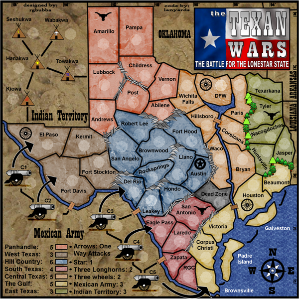
rgbubba wrote:One way arrow attacks and cannon to cannon.
Right, that's what I figured with the one-way arrows. But by cannon to cannon do you mean they can attack each other, even if not attached by a marked attack route? Because I liked the idea of the two Mexican battalions being cut-off from each other without first going through Texas. This is, after all, a Texas map, and you don't want the focus to be on fighting within mexico.

oaktown wrote:rgbubba wrote:One way arrow attacks and cannon to cannon.
Right, that's what I figured with the one-way arrows. But by cannon to cannon do you mean they can attack each other, even if not attached by a marked attack route? Because I liked the idea of the two Mexican battalions being cut-off from each other without first going through Texas. This is, after all, a Texas map, and you don't want the focus to be on fighting within mexico.
My idea was to use what ww2 had with planes. They were divided in to different sections. Now if we need to put a line to c2 to c3 I will do so. I just wanted good game play.
rgbubba wrote:My idea was to use what ww2 had with planes. They were divided in to different sections. Now if we need to put a line to c2 to c3 I will do so. I just wanted good game play.
Ok, this is what I thought. I like them being divided, but somebody started saying above that the cannons could all attack each other, which didn't make any sense. The map seems fine as is.
oaktown wrote:rgbubba wrote:My idea was to use what ww2 had with planes. They were divided in to different sections. Now if we need to put a line to c2 to c3 I will do so. I just wanted good game play.
Ok, this is what I thought. I like them being divided, but somebody started saying above that the cannons could all attack each other, which didn't make any sense. The map seems fine as is.
Thank you for looking into it. I need to address one more concern on some text issues. I'm done with the map unless you have any other things needed to be worked on. I would like to address the code issues.
Last edited by rgbubba on Wed Mar 05, 2008 2:43 am, edited 2 times in total.
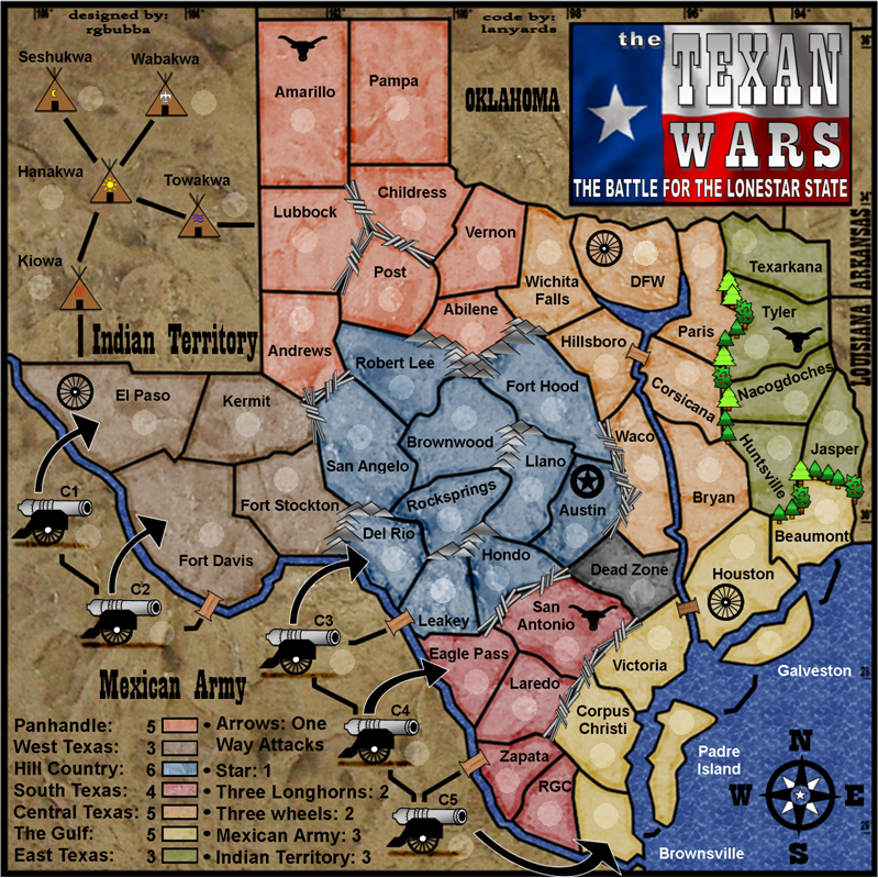
600x600 3-05-08

800x800 3-05-08
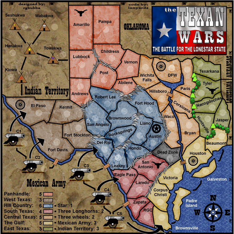
800x800 3-05-08
Last edited by rgbubba on Wed Mar 05, 2008 3:37 am, edited 2 times in total.

As someone who has to constantly answer questions about maps once they're in play in chat/etickets/forums, can I request you please put a short note to define that the arrows are one-way attack routes? I know the map is crowded, but I'm sure you creative folks can come up with something unobtrusive yet clear.
Also, the lines between Leaky/Hondo and Eagle Pass/Laredo look unnatural b/c they're so straight.
Just a suggestion, but lighten the colors and text in the NE corner (Oklahoma, Arkansas, Louisiana), and also make that text a bit smaller, to distinguish between attackable and unattackable areas ... since the same colored brown areas on the west side of the map are part of the attack areas. Push that area to the background, not the foreground.
And in case you haven't fixed it yet, the L in Laredo is the wrong font.
Sorry for the late suggestions, I know how much you guys like those. rgbubba just came in chat soliciting comments, hence my late entrance.
Also, the lines between Leaky/Hondo and Eagle Pass/Laredo look unnatural b/c they're so straight.
Just a suggestion, but lighten the colors and text in the NE corner (Oklahoma, Arkansas, Louisiana), and also make that text a bit smaller, to distinguish between attackable and unattackable areas ... since the same colored brown areas on the west side of the map are part of the attack areas. Push that area to the background, not the foreground.
And in case you haven't fixed it yet, the L in Laredo is the wrong font.
Sorry for the late suggestions, I know how much you guys like those.


aah he changed the L now, all's good there.
I see the other straight lines, but those seem more natural b/c of the area they're in... the flat plains. Those straight lined borders (mostly Leaky/Hondo & Leaky/Del Rio) I mentioned are coming off of mountians... borders in mountainous areas usually follow rivers (especially coming off at that angle), ergo straight lines look out of place there. Not a biggie, but it really stands out to me (but I also look at a lot of topo maps).
I see the other straight lines, but those seem more natural b/c of the area they're in... the flat plains. Those straight lined borders (mostly Leaky/Hondo & Leaky/Del Rio) I mentioned are coming off of mountians... borders in mountainous areas usually follow rivers (especially coming off at that angle), ergo straight lines look out of place there. Not a biggie, but it really stands out to me (but I also look at a lot of topo maps).
wicked wrote:aah he changed the L now, all's good there.
I see the other straight lines, but those seem more natural b/c of the area they're in... the flat plains. Those straight lined borders (mostly Leaky/Hondo) I mentioned are coming off of mountians... borders in mountainous areas usually follow rivers (especially coming off at that angle), ergo straight lines look out of place there. Not a biggie, but it really stands out to me (but I also look at a lot of topo maps).
I know that we can change alot but if we are changing borders does it really matter. I would have to go way backwards to fix it all.
If you would look at a texas map it's all striaght lines according to counties.
I don't really want to take other two months to fix it. I have used two different programs to get to this point. Please consiter how much it would set me back.
Last edited by rgbubba on Wed Mar 05, 2008 3:47 am, edited 1 time in total.

I would like to apologize to the diligent and awesome mapmaker, RG. I thought gameplay had all cannons able to attack one another. Instead, having them in groups makes the game much better, and, as Wicked pointed out, keeps the focus on TX instead of Mexico. Please accept my apology for not understanding this detail.
Because Wicked knows all, you should probably write out the "one-way attack" stipulation. Otherwise, it seems that the map is ready for quenching.
Congrats on an awesome map!
LMR
Because Wicked knows all, you should probably write out the "one-way attack" stipulation. Otherwise, it seems that the map is ready for quenching.
Congrats on an awesome map!
LMR
Thanks I will put in the one way attacks into the legend tonight. All I need is the code from lanyard then we can finish up.laci_mae wrote:I would like to apologize to the diligent and awesome mapmaker, RG. I thought gameplay had all cannons able to attack one another. Instead, having them in groups makes the game much better, and, as Wicked pointed out, keeps the focus on TX instead of Mexico. Please accept my apology for not understanding this detail.
Because Wicked knows all, you should probably write out the "one-way attack" stipulation. Otherwise, it seems that the map is ready for quenching.
Congrats on an awesome map!
LMR