Care to peruse completed maps? Take a stroll through the Atlas.
Moderator: Cartographers
WidowMakers
Posts: 2774 Joined: Mon Nov 20, 2006 9:25 amGender: MaleLocation: Detroit, MI
Post
by WidowMakers Sat Jan 12, 2008 12:53 pm
Lone.prophet wrote: i kinda got a problem now the army cicles are 19 pixel and i have no clue how to make em nice 20 without placing them different anyone knows?
That is how I do all of my maps. I make and place individual circles for each territory for each size map. Make a copy of the large map without circles. Scale it down to the small size and then add all of the circles again.
WM
Lone.prophet
Posts: 1467 Joined: Thu Oct 12, 2006 4:37 pmLocation: Your basement Muahaha
Post
by Lone.prophet Sat Jan 12, 2008 3:00 pm
than they arent on the same spot
WidowMakers
Posts: 2774 Joined: Mon Nov 20, 2006 9:25 amGender: MaleLocation: Detroit, MI
Post
by WidowMakers Sat Jan 12, 2008 3:06 pm
Lone.prophet wrote: than they arent on the same spot
Correct. Like I said I always need to move my circles when I make smaller maps. Thats why some people choose to not use circles. Then when you scale there are not as many issues.
WM
edbeard
Posts: 2501 Joined: Thu Mar 29, 2007 12:41 am
Post
by edbeard Sat Jan 12, 2008 4:09 pm
I also get the problem that when I resize, my circles become distorted.
oaktown
Posts: 4451 Joined: Sun Dec 03, 2006 9:24 pmLocation: majorcommand
Post
by oaktown Sat Jan 12, 2008 8:26 pm
I agree with Widow... when you scale the entire image with the circles you may run into the small circles being an even number of pixels in height and width, which means the numbers (which have odd dimensions) will never be aligned properly.
Lone.prophet
Posts: 1467 Joined: Thu Oct 12, 2006 4:37 pmLocation: Your basement Muahaha
Post
by Lone.prophet Sun Jan 13, 2008 7:43 am
the army circels need to be an even number
Lone.prophet
Posts: 1467 Joined: Thu Oct 12, 2006 4:37 pmLocation: Your basement Muahaha
Post
by Lone.prophet Mon Jan 14, 2008 9:30 am
ok here is everything
Code: Select all
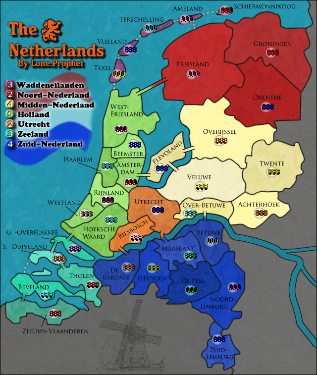
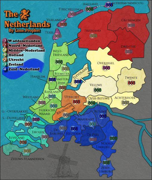
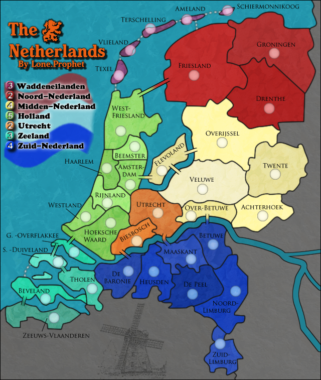
<?xml version="1.0"?>Large map:
Small map:
Large with army numbers:
Small with army number:
Last edited by
Lone.prophet on Tue Jan 15, 2008 4:23 am, edited 3 times in total.
gimil
Posts: 8599 Joined: Sat Mar 03, 2007 12:42 pmGender: MaleLocation: United Kingdom (Scotland)
Post
by gimil Mon Jan 14, 2008 4:21 pm
small map has a few coordianted off:
-maaskant
-Westland
-Haarlem
That all i can see
What do you know about map making, bitch natty_dread wrote: I was wrong
Top Score:2403
Lone.prophet
Posts: 1467 Joined: Thu Oct 12, 2006 4:37 pmLocation: Your basement Muahaha
Post
by Lone.prophet Tue Jan 15, 2008 4:24 am
updated the post
yeti_c
Posts: 9624 Joined: Thu Jan 04, 2007 9:02 amGender: Male
Post
by yeti_c Tue Jan 15, 2008 2:04 pm
There's quite often a requirement for displaying triple digits on your map.
Highest score : 2297
Lone.prophet
Posts: 1467 Joined: Thu Oct 12, 2006 4:37 pmLocation: Your basement Muahaha
Post
by Lone.prophet Tue Jan 15, 2008 2:18 pm
poeh the bureaucracy
yeti_c
Posts: 9624 Joined: Thu Jan 04, 2007 9:02 amGender: Male
Post
by yeti_c Tue Jan 15, 2008 2:20 pm
Lone.prophet wrote: poeh the bureaucracy
Just trying to help.
C.
Highest score : 2297
timme10
Posts: 16 Joined: Mon Jul 09, 2007 5:32 amLocation: Australia
Post
by timme10 Tue Jan 15, 2008 7:40 pm
hm with the triple digits is there anyway to make the 2nd digit go in the centre of the circle? it would look better
Coleman
Posts: 5402 Joined: Tue Jan 02, 2007 10:36 pmGender: MaleLocation: Midwest
Post
by Coleman Tue Jan 15, 2008 7:50 pm
timme10 wrote: hm with the triple digits is there anyway to make the 2nd digit go in the centre of the circle? it would look better
In the interest of being nice I'm just going to say NO, and never ever suggest that again.
Double checking your xml. Hope nobody feels patronized when I do that, it's just almost all maps release with bugs lately and I'd really like to avoid it.
Warning:
pepperonibread
Posts: 954 Joined: Sun Jan 28, 2007 4:33 pmLocation: The Former Confederacy
Post
by pepperonibread Tue Jan 15, 2008 8:19 pm
unriggable wrote: Looks good. Quench?
Nah, let's keep this til page 100 or so, let it sit a while longer...
Lone.prophet
Posts: 1467 Joined: Thu Oct 12, 2006 4:37 pmLocation: Your basement Muahaha
Post
by Lone.prophet Wed Jan 16, 2008 2:46 am
Coleman wrote: timme10 wrote: hm with the triple digits is there anyway to make the 2nd digit go in the centre of the circle? it would look better
In the interest of being nice I'm just going to say NO, and never ever suggest that again.
Double checking your xml. Hope nobody feels patronized when I do that, it's just almost all maps release with bugs lately and I'd really like to avoid it.
ohh no problem there coleman
Lone.prophet
Posts: 1467 Joined: Thu Oct 12, 2006 4:37 pmLocation: Your basement Muahaha
Post
by Lone.prophet Wed Jan 16, 2008 12:18 pm
Code: Select all
http://i150.photobucket.com/albums/s113/prophetlone/TheNetherlandsLarge.pngCode: Select all
http://i150.photobucket.com/albums/s113/prophetlone/TheNetherlandsSmall.pngCode: Select all
http://www.mediafire.com/?7ty1yg2x7tmhere are all the upload locations
and are the pictures supposed to be png or jpg?
Last edited by
Lone.prophet on Wed Jan 16, 2008 12:31 pm, edited 2 times in total.
Coleman
Posts: 5402 Joined: Tue Jan 02, 2007 10:36 pmGender: MaleLocation: Midwest
Post
by Coleman Wed Jan 16, 2008 12:22 pm
Both are accepted types so it doesn't matter, I prefer png.
Warning:
Lone.prophet
Posts: 1467 Joined: Thu Oct 12, 2006 4:37 pmLocation: Your basement Muahaha
Post
by Lone.prophet Wed Jan 16, 2008 12:25 pm
ohh lol ill upload some png than
Lone.prophet
Posts: 1467 Joined: Thu Oct 12, 2006 4:37 pmLocation: Your basement Muahaha
Post
by Lone.prophet Wed Jan 16, 2008 12:32 pm
does he mind the links are that way or do i have to upload the actual file too?
Lone.prophet
Posts: 1467 Joined: Thu Oct 12, 2006 4:37 pmLocation: Your basement Muahaha
Post
by Lone.prophet Thu Jan 17, 2008 4:17 am
gimil wrote: Okey im going to go ahead and do this:
oaktown wrote: Works for me.
now your stamp coleman