Page 23 of 38
Re: Napoleonic Europe 1812 - Ver 36/41 [Gp] waiting for GR s
Posted: Fri Jun 18, 2010 5:32 am
by Kabanellas
I think we should wait first for a word from the Men in Blue, before doing any update to the XML.
Re: Napoleonic Europe 1812 - Ver 36/41 [Gp] waiting for GR s
Posted: Fri Jun 18, 2010 11:55 am
by Raskholnikov
Re: Napoleonic Europe 1812 - Ver 36/41 [Gp] waiting for GR s
Posted: Sat Jun 19, 2010 11:06 pm
by Incandenza
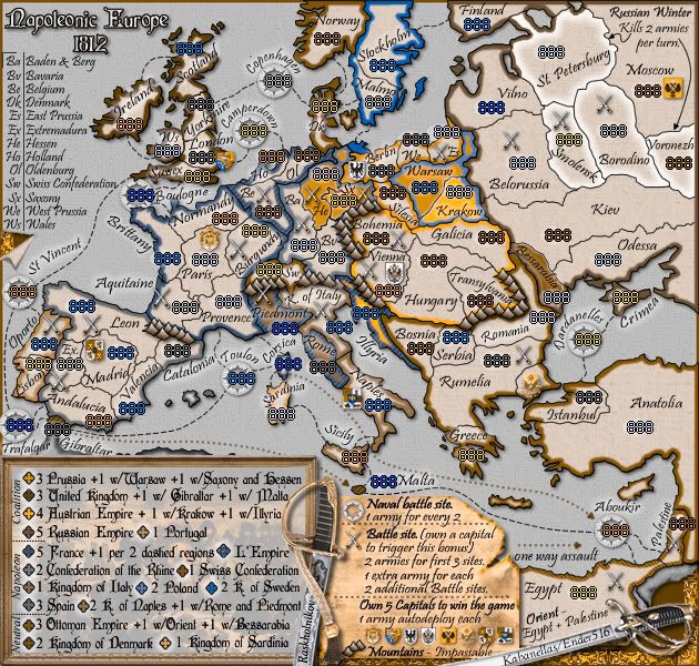
That whole area in the general Schlesswig-Holstein vicinity looks needlessly complex on the small map, can't that be cleaned up and/or simplified a bit to make the terit connections there a bit more visible? It's not necessarily something you'd need for the large map, but on the small it's like you're intentionally trying to minimize the He-Dk connection. You could get rid of that strait between Ol and De (which is almost impossible to see anyway), and rejigger a few of the borders, and presto, much clearer.
Re: Napoleonic Europe 1812 - Ver 36/41 [Gp] waiting for GR s
Posted: Sat Jun 19, 2010 11:22 pm
by Army of GOD
Really? They look obviously connected to me. You can tell that Ol is nestled nicely into Dk...
Re: Napoleonic Europe 1812 - Ver 36/41 [Gp] waiting for GR s
Posted: Sun Jun 20, 2010 4:32 am
by Kabanellas
Incandenza wrote:You could get rid of that strait between Ol and De (which is almost impossible to see anyway), and rejigger a few of the borders, and presto, much clearer.
I could do that on the small map... Though those borders seem quite clear to me and we would be losing in the realistic aspect. But again, if some of you guys find it hard to see that would be enough for me....
Re: Napoleonic Europe 1812 - Ver 36/41 [Gp] waiting for GR s
Posted: Sun Jun 20, 2010 5:05 am
by Raskholnikov
Well Kab if that's enough for you without even asking me if I agree, as I always do with you when ppl suggest changes and I reply, why don't we just replace all territories with neat equal squares everyone can see and just play it like that? Now we're beginning to change borders and have fake maps parts???? I'm sorry I just won't go that far. If we begin to change real borders, just please take my name off the map and do what you want with it. It's all yours.
Re: Napoleonic Europe 1812 - Ver 36/41 [Gp] waiting for GR s
Posted: Sun Jun 20, 2010 5:16 am
by Kabanellas
Sorry Rask, I really didn’t mean to go over your opinion on that. I just thought that you’d rather leave those ‘difficult ’ changes to my responsibility at this point.
Btw, you’d have to sue me first before I take your name out of this map

Re: Napoleonic Europe 1812 - Ver 36/41 [Gp] waiting for GR s
Posted: Sun Jun 20, 2010 5:18 am
by Raskholnikov
LOL

I'm on msn if u want to chat.
Re: Napoleonic Europe 1812 - Ver 36/41 [Gp] waiting for GR s
Posted: Sun Jun 20, 2010 6:17 am
by natty dread
IMO the Ol - Dk connection is clear enough on both versions. If you need a compromise though, how about a sea route line between them in the small version?
Re: Napoleonic Europe 1812 - Ver 36/41 [Gp] waiting for GR s
Posted: Sun Jun 20, 2010 11:12 am
by jefjef
natty_dread wrote:IMO the Ol - Dk connection is clear enough on both versions.
I agree.
It's obvious they connect. But if it makes it easier maybe close half that straight and maybe others will stop trying to find probs that don't exist.
Now if I were to nitpick anything It might look a little better if you adjust
St. Petersburg to where it's not tilted. You have the room to do it and it would be the same as all the others in that region (Cept Smolensk of course).
Re: Napoleonic Europe 1812 - Ver 36/41 [Gp] waiting for GR s
Posted: Sun Jun 20, 2010 8:01 pm
by Incandenza
The Ol-De connection isn't the problem, it's the solution, if you'll re-read what I wrote.
Incandenza wrote:That whole area in the general Schlesswig-Holstein vicinity looks needlessly complex on the small map, can't that be cleaned up and/or simplified a bit to make the terit connections there a bit more visible? It's not necessarily something you'd need for the large map, but on the small it's like you're intentionally trying to minimize the He-Dk connection. You could get rid of that strait between Ol and De (which is almost impossible to see anyway), and rejigger a few of the borders, and presto, much clearer.
Rask, I'm sorry you've never quite figured out that these are game boards, not absolutely true-to-life-in-every-last-detail maps. Legibility comes before historical accuracy when there's a conflict, always.
Re: Napoleonic Europe 1812 - Ver 36/41 [Gp] waiting for GR s
Posted: Tue Jun 22, 2010 1:24 am
by Army of GOD
Incandenza wrote:The Ol-De connection isn't the problem, it's the solution, if you'll re-read what I wrote.
Incandenza wrote:That whole area in the general Schlesswig-Holstein vicinity looks needlessly complex on the small map, can't that be cleaned up and/or simplified a bit to make the terit connections there a bit more visible? It's not necessarily something you'd need for the large map, but on the small it's like you're intentionally trying to minimize the He-Dk connection. You could get rid of that strait between Ol and De (which is almost impossible to see anyway), and rejigger a few of the borders, and presto, much clearer.
Rask, I'm sorry you've never quite figured out that these are game boards, not absolutely true-to-life-in-every-last-detail maps. Legibility comes before historical accuracy when there's a conflict, always.
Ok, didn't see you wrote "He" the first time. I don't think there's a problem with not being able to see if He and Dk connect, but that the little piece of He that DOES connect with Dk might be difficult for some people to see that it is actually part of He (because the border kind of "closes" in between them). Perhaps just put a little strip of orange between them?
Re: Napoleonic Europe 1812 - Ver 36/41 [Gp] waiting for GR s
Posted: Tue Jun 22, 2010 3:19 am
by pamoa
same in Warsaw
Re: Napoleonic Europe 1812 - Ver 36/41 [Gp] waiting for GR s
Posted: Tue Jun 22, 2010 11:14 am
by Kabanellas
I've made some changes, with Rask's agreement, to the original borders, making them more perceptible.
[bigimg]http://i998.photobucket.com/albums/af105/Kabanellas/NapoleonicEurope_V40e_Image_small.png[/bigimg]
Re: Napoleonic Europe 1812 - Ver 36/41 [Gp] waiting for GR s
Posted: Tue Jun 22, 2010 1:08 pm
by natty dread
Well, the Warsaw-Vilno connection is very clear now. As for Dk-He... I don't notice much (any) differnce to previous version, but to me it seems clear enough. If someone has a poor vision and can't see the connection, then they should be using the large map anyway...
I think you've done a good job cramming as much information as can be crammed into 630x600 pixels. Graphics stamp shouldn't be far now
Re: Napoleonic Europe 1812 - Ver 36/41 [Gp] waiting for GR s
Posted: Tue Jun 22, 2010 5:02 pm
by Kabanellas
natty_dread wrote:I think you've done a good job cramming as much information as can be crammed into 630x600 pixels. Graphics stamp shouldn't be far now
Ohhh God!!!!!!!!

Re: Napoleonic Europe 1812 - Ver 36/41 [Gp] waiting for GR s
Posted: Wed Jun 23, 2010 8:58 am
by Raskholnikov
Nah, I don't believe it.
Re: Napoleonic Europe 1812 - Ver 36/41 [Gp] waiting for GR s
Posted: Wed Jun 23, 2010 6:28 pm
by thenobodies80
First of all i want to say that the small map doesn't look bad , but i think you should fix some things. As previously mentioned to Kab, before posting I've talked a bit with the other blue guys to understand their opinion about this map. We come up with some suggestions, but i'm going to post only what i think needs to be changed to make this map perfectly playable:
Colorblind IssuesKingdom of Italy has almost the same color of Naples and Sicily (look
this image for reference)
A bit less than the previous one but also Bessarabbia color could create some confusion (try a lighter green for russia?)
SpaceSome parts are cluttered, the northern part of Europe is better, but i think that Incandenza was referring to something like this as result:

I did it in a couple of minutes without the layers, so you should fix this in seconds
Also the english channel is bit a mess, i'd suggest to move all the British Isles a bit to north (no one will notice the difference), maybe removing/editing a bit the english/french borders. In this way you can make some free space to fit better the boulogne circle and to do easier/clearer connections.
The example is not perfect but can give you an idea:
 Legend
This could be a personal preference, but did you try a different font for the legend? (only on the small map).
The current one is very nice (graphically speaking) wi but is not the best userfriendly choice, since it's a bit hard to read with all those embellishments.
Abbreviation ListAnother small thing to fix is the abbreviation list on the left:
OL doesn't look aligned with the others abbreviations on the list and Sx should be moved up to have the same space between the lines and not to have the name overlapped with west prussia.
The two black lines the makes a right angle at the top of the list are necessary?
Can you make a bit more noticeable the small diagonal lines on the Orient brown border?
A question, it's possible to reduce a bit the sword icon? Just asking , don't do it if it looks bad
An advice: if you need more space, you should consider to remove the non playable islands on the map (example cyprus and crete)
Personally i hate where the one way connection from gibraltar to malta disappears behind the legend but it's just a personal preference since nobody else dislike it.
Apart from the above, I don't see other things that must be changed.
Go guys! It's the last climb
Nobodies
Re: Napoleonic Europe 1812 - Ver 36/41 [Gp] waiting for GR s
Posted: Wed Jun 23, 2010 7:20 pm
by Incandenza
nobodies hit the nail on the head, that's exactly what I'm talking about. You could even widen the northernmost part of He a bit (in a westward direction).
Re: Napoleonic Europe 1812 - Ver 36/41 [Gp] waiting for GR s
Posted: Thu Jun 24, 2010 2:28 am
by Raskholnikov
Lol KAb, at least this is super specific and - hopefully!- comprehensive. If you're up to it, I'm OK with it all.
Re: Napoleonic Europe 1812 - Ver 36/41 [Gp] waiting for GR s
Posted: Thu Jun 24, 2010 7:06 am
by Kabanellas
Thanks a lot nobodies for your post (and effort). I think that with this very objective analysis we may bring this project to an end!
Re: Napoleonic Europe 1812 - Ver 36/41 [Gp] waiting for GR s
Posted: Sat Jun 26, 2010 12:26 pm
by Kabanellas
I think I've covered all your points nobodies
as for that connection line... well I really like it. It's just like it was there all the time but someone covered it with the board.
[bigimg]http://i998.photobucket.com/albums/af105/Kabanellas/NapoleonicEurope_V42_Image_small.png[/bigimg]
Re: Napoleonic Europe 1812 - Ver 36/41 [Gp] waiting for GR s
Posted: Sat Jun 26, 2010 12:38 pm
by natty dread
Sorry for bringing this up so late, but I just noticed it myself.
Does anyone think the Lund-Norway connection is a bit hard to see on the small?
Re: Napoleonic Europe 1812 - Ver 36/41 [Gp] waiting for GR s
Posted: Sat Jun 26, 2010 2:20 pm
by Incandenza
natty_dread wrote:Sorry for bringing this up so late, but I just noticed it myself.
Does anyone think the Lund-Norway connection is a bit hard to see on the small?
Didn't even realize they touched, so that would be a yes.
Re: Napoleonic Europe 1812 - Ver 36/41 [Gp] waiting for GR s
Posted: Sat Jun 26, 2010 2:24 pm
by ender516
Incandenza wrote:natty_dread wrote:Sorry for bringing this up so late, but I just noticed it myself.
Does anyone think the Lund-Norway connection is a bit hard to see on the small?
Didn't even realize they touched, so that would be a yes.
Seconded. (Man, I rely on BOB so much.) Though I do wonder, sometimes, if perhaps a map should have the occasional sneaky bit like this, just to make players examine the map as carefully as all the Foundry folk do, hmm?