Page 3 of 5
Re: Rwanda V3-NEW VERSION
Posted: Tue Apr 21, 2009 4:56 pm
by the.killing.44
sailorseal wrote:the.killing.44 wrote:sailorseal wrote:Alright this idea was suggested by Kill
what?!?!?!??!!??!
.44
Don't lie man, that's not cool, you suggested Rwanda
Not in the least!!!! I can think of many reasons not to do Rwanda, not that I would suggest it.
Sorry to spam, I'm done here.
.44
Re: Rwanda V3-NEW VERSION
Posted: Tue Apr 21, 2009 5:01 pm
by Incandenza
First off, it doesn't matter whose idea it was, sailor. You put your name on it, it's your map.
And I share the general unease of other posters. While I do think we could do with more africa maps, this isn't the way to do it. Rwanda is unfortunately famous for one thing, and the map as currently constituted draws attention to that. It'd be like if you made a 1930's era map of Nanking with rape zones that give you a -1.
Now, if you wanted to pull out a bit, and do a "Lake Victoria and environs" map, that would be a much better idea.
Re: Rwanda V3-NEW VERSION
Posted: Tue Apr 21, 2009 5:04 pm
by Bones2484
What about Kenya. And incorporate some sort of nature theme.
Re: Rwanda V3-NEW VERSION
Posted: Tue Apr 21, 2009 5:29 pm
by thenobodies80
Seems clear that if you want continue this map you would have to change the theme.
And a "flat" geographical map actually is the best choice with this country.
But i don't know if the map could be so interesting....
Re: Rwanda V3-NEW VERSION
Posted: Tue Apr 21, 2009 6:26 pm
by AndyDufresne
Incandenza wrote:Now, if you wanted to pull out a bit, and do a "Lake Victoria and environs" map, that would be a much better idea.
I'm fond of Incandenza's idea.
--Andy
Re: Rwanda V3-NEW VERSION
Posted: Tue Apr 21, 2009 7:00 pm
by MrBenn
alstergren wrote:I don't think this is a good idea. I.e. basing the map on the genocide with safe, neutral and danger zones...
MrBenn wrote:Here's my initial feedback/thoughts:
Firstly, Rwanda is a country that cannot help but be associated with atrocities of the past.... While I wouldn't want to celebrate genocide in any shape or form, there is definitely some scope to add some history to the map - perhaps by incorporating a pre 1990/post 1994 aspect to it? The following map...[is] difficult to make out clearly, but further research could give an interesting backstory and theme to the map?
Q: What the hell were you thinking?
I've just re-read this post, and it's sent a shiver down my spine (not in a good way)... The theme I had in mind was slightly more "Hotel Rwanda", but the paragraph above is worded really really badly

-
I have now edited it slightly.
Re: Rwanda V3-NEW VERSION
Posted: Tue Apr 21, 2009 7:16 pm
by oaktown
this is a project that is just frought with question marks for me. I have to wonder - why Rwanda? On the world stage it's not a major player, and I doubt there are many CC users who have close personal ties to the region. While a strictly political map of 2009 Rwanda might make for a fine map, doesn't seem like a terribly compelling subject to take on and may not drum up much support.
On the other hand, you could take it back 20 years and make a map of the Civil war and resulting genocide; while this would make for a far more interesting project as you reflect the influence of Hutus, Tutsis, and the revolutionary movements, you of course get into the questions of taste level as mentioned above.
If it were me I'd expand the region, again as mentioned above, and perhaps take it back further in time to the 60s/70s - independence, nation buidling, European influence, conflict with neighboring countries such as Burundi, etc. Or you could really go back and do a scramble for Africa map, which would be a very ambitious yet rocking map.
The latest version of the map is very nice looking - I really can't find fault with it. But it could be a map of anywhere - it desperately needs flavor.
Re: Rwanda V3-NEW VERSION
Posted: Tue Apr 21, 2009 9:32 pm
by sailorseal
oaktown wrote:this is a project that is just frought with question marks for me. I have to wonder - why Rwanda? On the world stage it's not a major player, and I doubt there are many CC users who have close personal ties to the region. While a strictly political map of 2009 Rwanda might make for a fine map, doesn't seem like a terribly compelling subject to take on and may not drum up much support.
On the other hand, you could take it back 20 years and make a map of the Civil war and resulting genocide; while this would make for a far more interesting project as you reflect the influence of Hutus, Tutsis, and the revolutionary movements, you of course get into the questions of taste level as mentioned above.
If it were me I'd expand the region, again as mentioned above, and perhaps take it back further in time to the 60s/70s - independence, nation buidling, European influence, conflict with neighboring countries such as Burundi, etc. Or you could really go back and do a scramble for Africa map, which would be a very ambitious yet rocking map.
The latest version of the map is very nice looking - I really can't find fault with it. But it could be a map of anywhere - it desperately needs flavor.
Good Idea
Re: Colonial Rwanda V4-NEWER VERSION
Posted: Wed Apr 22, 2009 5:33 pm
by sailorseal
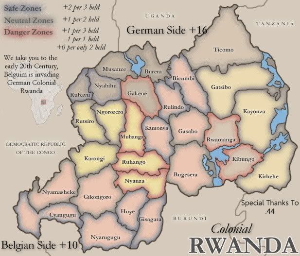
Now I have made it Colonial Rwanda, I need help clarifying the flags, (They are the same

)
Also I kept Danger and all that but I am going to clarify the outlines vs. The inside
Re: Colonial Rwanda V4-NEWER VERSION
Posted: Wed Apr 22, 2009 5:37 pm
by Bones2484
One quick critique: If this is early 20th century, the country to the west of Rwanda is not named "The Democratic Republic of the Congo".
Anyways. I'm having trouble figuring out what direction this map is going in. Can you explain the gameplay any better?
Re: Colonial Rwanda V4-NEWER VERSION
Posted: Wed Apr 22, 2009 5:39 pm
by sailorseal
Bones2484 wrote:One quick critique: If this is early 20th century, the country to the west of Rwanda is not named "The Democratic Republic of the Congo".
Anyways. I'm having trouble figuring out what direction this map is going in. Can you explain the gameplay any better?
I am planning on taking it back to Colonial Rwanda and in the next version I will clarify
Thanks

Re: Colonial Rwanda V4-NEWER VERSION
Posted: Wed Apr 22, 2009 6:00 pm
by bryguy
1) I suggest that you change the wording (On top of the Africa image) so that it says something different, because currently it seems grammatically incorrect. Perhaps "We take you to the early 20th Century, when (Where?) Belgium is invading German Colonial Rwanda." The only difference really is the addition of when or where.
2) The colors seem to have changed since V3. Currently they are much more.... harsh. That is the only word that I can think of that effectively describes them.
3) Belgian Side +10, German Side +16, how is one to tell the difference between sides?
4) Compared to the +s, the -s are much smaller. Perhaps manually modify the -s to make them larger?
5) Is the image of Africa one of your creation? Just wondering
6) Perhaps so that one may more easily see where Rwanda is on the image of Africa, you could overlay the outlines of some, if not all (I know that some are very small), of the separate countries?
7) I suggest you move German Side over a little to the left, so that the 6 in 16 is easier to read (Also, it annoys the heck out of me when lines go through words)

Which flags do you need help clarifying? (What countries flags)
Re: Colonial Rwanda V4-NEWER VERSION
Posted: Wed Apr 22, 2009 6:04 pm
by the.killing.44
bryguy wrote:5) Is the image of Africa one of your creation? Just wondering
I took a political map of Africa, erased all but the continental border, filled and pattern overlay. Then I took a box around it and added a red stroke.
.44
Re: Colonial Rwanda V4-NEWER VERSION
Posted: Wed Apr 22, 2009 6:10 pm
by oaktown
sailorseal wrote:I am planning on taking it back to Colonial Rwanda and in the next version I will clarify
I am also looking forward to seeing what your vision is for this project... the latest version just looks like your old map with the addition of the word "Colonial." I think your image is very good looking, but nothing about it is very early 20th century.
Re: Colonial Rwanda V4-NEWER VERSION
Posted: Wed Apr 22, 2009 6:12 pm
by the.killing.44
oaktown wrote:sailorseal wrote:Anyways. I'm having trouble figuring out what direction this map is going in.
I am planning on taking it back to Colonial Rwanda and in the next version I will clarify
I am also looking forward to seeing what your vision is for this project... the latest version just looks like your old map with the addition of the word "Colonial." I think your image is very good looking, but nothing about it is very early 20th century.[/quote]
His computer is retarded and won't accept my .psd, only .psf's, which is why the image looks so similar.

I do agree with you though.
.44
Re: Colonial Rwanda V4-NEWER VERSION
Posted: Wed Apr 22, 2009 6:20 pm
by Incandenza
Just calling it "Colonial" Rwanda doesn't change the essential problems with creating a map of the country, and the more you persist with a Rwanda map of any stripe, the more I kinda have to question your motives. You're not creating a map that strongly resonates with one of the defining genocides of the late 20th century by accident. This map has certainly gotten a lot more attention than if you'd used, say, Cameroon, but that's not necessarily a good thing. I imagine a Killing Fields or Srebrenica or Columbine map would attract similar attention.
Re: Colonial Rwanda V4-NEWER VERSION
Posted: Wed Apr 22, 2009 6:32 pm
by sailorseal
bryguy wrote:1) I suggest that you change the wording (On top of the Africa image) so that it says something different, because currently it seems grammatically incorrect. Perhaps "We take you to the early 20th Century, when (Where?) Belgium is invading German Colonial Rwanda." The only difference really is the addition of when or where.
2) The colors seem to have changed since V3. Currently they are much more.... harsh. That is the only word that I can think of that effectively describes them.
3) Belgian Side +10, German Side +16, how is one to tell the difference between sides?
That's the flag thing, the new "Harsh" colors together make a flag, look at it,sadly the German and Belgian flags use the same colors4) Compared to the +s, the -s are much smaller. Perhaps manually modify the -s to make them larger?
Will do6) Perhaps so that one may more easily see where Rwanda is on the image of Africa, you could overlay the outlines of some, if not all (I know that some are very small), of the separate countries?
7) I suggest you move German Side over a little to the left, so that the 6 in 16 is easier to read (Also, it annoys the heck out of me when lines go through words)
Will do Which flags do you need help clarifying? (What countries flags)
The new colors See 3)Thanks for all the tips
Re: Colonial Rwanda V4-NEWER VERSION
Posted: Wed Apr 22, 2009 6:45 pm
by LED ZEPPELINER
you need to specify the flag a little better, maybe make a big border through the middle dividing it or something
Re: Colonial Rwanda V4-NEWER VERSION
Posted: Wed Apr 22, 2009 6:59 pm
by tlane
Incandenza wrote:Just calling it "Colonial" Rwanda doesn't change the essential problems..,
oaktown wrote:sailorseal wrote:Anyways. I'm having trouble figuring out what direction this map is going in.
I am planning on taking it back to Colonial Rwanda and in the next version I will clarify
I am also looking forward to seeing what your vision is for this project... the latest version just looks like your old map with the addition of the word "Colonial." I think your image is very good looking, but nothing about it is very early 20th century.[/quote]
I think these two comments show that you need to really get a set plan in your head, on what you are going to do. If it is going to be a "Colonial" map, then you should change it more besides just putting the word colonial in.
Graphically - this map looks nice, .44 does a great job with graphics.
I dont want to make comments on gameplay, for I hope when you decide where this map is going that you base the gameplay off of that (colonial and danger zones are two different ways you can go, i don't think both would go very well).
I am also getting confused with the sides, I cant tell where the Belgian side is and where the German side is (clarify).
cant wait to see which way you go with this map
tlane
Re: Colonial Rwanda V4-NEWER VERSION
Posted: Wed Apr 22, 2009 7:03 pm
by sailorseal
tlane wrote:Incandenza wrote:Just calling it "Colonial" Rwanda doesn't change the essential problems..,
oaktown wrote:sailorseal wrote:Anyways. I'm having trouble figuring out what direction this map is going in.
I am planning on taking it back to Colonial Rwanda and in the next version I will clarify
I am also looking forward to seeing what your vision is for this project... the latest version just looks like your old map with the addition of the word "Colonial." I think your image is very good looking, but nothing about it is very early 20th century.
I think these two comments show that you need to really get a set plan in your head, on what you are going to do. If it is going to be a "Colonial" map, then you should change it more besides just putting the word colonial in.
Graphically - this map looks nice, .44 does a great job with graphics.
I dont want to make comments on gameplay, for I hope when you decide where this map is going that you base the gameplay off of that (colonial and danger zones are two different ways you can go, i don't think both would go very well).
I am also getting confused with the sides, I cant tell where the Belgian side is and where the German side is (clarify).
cant wait to see which way you go with this map
tlane[/quote]
Not sure what...this means... but alright
Re: Colonial Rwanda V4-NEWER VERSION
Posted: Wed Apr 22, 2009 9:16 pm
by SultanOfSurreal
Incandenza wrote:Just calling it "Colonial" Rwanda doesn't change the essential problems with creating a map of the country, and the more you persist with a Rwanda map of any stripe, the more I kinda have to question your motives. You're not creating a map that strongly resonates with one of the defining genocides of the late 20th century by accident. This map has certainly gotten a lot more attention than if you'd used, say, Cameroon, but that's not necessarily a good thing. I imagine a Killing Fields or Srebrenica or Columbine map would attract similar attention.
come on man it's not a map of the columbine massacre it's just a map of the school!! And Srebrenica happens to be a fascinating region that makes for good gameplay.

ok seriously though this map is an awful idea and no matter what it actually depicts, players are going to see "Rwanda" and think CC has a genocide map. So I don't see how this map can ever be made to work. In fact I'm pretty much aghast that the response to this hasn't been a universal smack upside the head for even thinking this is a good idea.
Re: Colonial Rwanda V4-NEWER VERSION
Posted: Thu Apr 23, 2009 3:32 am
by alster
Well. If you want to take this making it into a historical map I think you need to get your facts straight. "Early 20th Century". Call WWI for WWI or, even better, "The Great War". I'm also a bit puzzled re the focus on Belgium, what happened to the UK? Also, use the correct borders/scope of the German possession in this region at the time if going historical. As it is now, it's just the old map disguised into something that isn't very historical.
Re: Colonial Rwanda V4-NEWER VERSION
Posted: Thu Apr 23, 2009 12:30 pm
by Incandenza
SultanOfSurreal wrote:In fact I'm pretty much aghast that the response to this hasn't been a universal smack upside the head for even thinking this is a good idea.
Yeah, what he said.
Re: Colonial Rwanda V4-NEWER VERSION
Posted: Thu Apr 23, 2009 4:24 pm
by sailorseal
New Version!
Re: Colonial Rwanda V5
Posted: Fri Apr 24, 2009 1:06 am
by TaCktiX
An interesting idea with some potential. Here's what I'm seeing:
Gameplay- The explanation for Danger Zones is very confusing, and overall, bad gameplay. In a 1v1, a player could end up with some nasty deploys if he drops with merely one. Instead of it being -1 per 1 held and +0 per 2 held, why not a decay of -1 and the original +1 per 3 bonus be preserved? It would be better gameplay and easier to understand.
- German Side and Belgian Side...can we have better terms? They seem so generic. How about use the German term for the country in the right, and the Belgian term for it in the left? Actually, I did some
research, and the use of German and Belgian isn't accurate, as Belgium and Britain fully took over the colony in the wake of WWI. Going with simply Belgian Holdings and British Holdings would be more accurate to the time period, and a better set of terms in general.
- Where are you deriving the Side bonuses from? They are completely out of line with the size of the map. In fact, if you want to have the two sides have special importance, make it an objective. Fully hold one half or the other and you win. Or reduce the bonus values, taking into account the bonus you would already get from the normal Zone bonuses.
- You're going to need to take a hard look at the distribution of the safe, neutral, and danger zones. The lack of impassables on the left side somewhat balances it, but makes the entire area near-unholdable.
- Fudge some impassables on the left side to make it a little easier to hold in any manner. Take into account local rivers, or mountains if you can. You can use the Mwogo river fairly easily.
- Small question: what time period are the territory names coming from?
Graphics:
- BelgIUm in the introduction text.
- PLEASE increase the quality of your output JPEGs. Size is a non-issue in the Foundry (unless it's too big pixel-wise), and the compression is killing the color quality something awful. Pixelation is baed.
- The assumption of reading across with the Zone bonus is easy to confuse. Stick it in a nice cut-apart with maybe a nice graphical cue like +2 per 3 held being the same blue as Safe Zones.
- Belgian being sideways and German being right ways up is jarring. If at all possible, make them have the same general orientation. It'll also help fix the fact that Belgian Side overlaps several territory names.
- Congo's name is smaller and not S P A C E D out like the other countries.
- Shnazz that title. Show us some local color! Like their flag, which is a beautiful multi-shade:
I do believe that's all for now. Consider your map
