Page 18 of 34
Posted: Tue Jun 05, 2007 4:39 pm
by DiM
much better than the previous versions

Posted: Tue Jun 05, 2007 4:43 pm
by Wisse
DiM wrote:much better than the previous versions
ah thnx *pfew* i thought it would mayby be worst
Posted: Wed Jun 06, 2007 5:51 am
by Wisse
can more say if they like the mountains or not, if most say it is good, then there is more chance to get this quenched,
(please do not say you like it if you don't like it but want it quenched because i don't want a quenched map with something nobody likes)
Posted: Wed Jun 06, 2007 5:53 am
by yeti_c
1 point (I apologise if this has been raised before) but... the Great Wall of China...
It was built to keep the Rampaging Mongolians out of China... Not to keep the subjugated peasants in China...
Shouldn't that attack line go the other way round?
(See Hadrians wall in UK - Designed to keep the pesky Scots out of England)
C.
Posted: Wed Jun 06, 2007 5:56 am
by Wisse
yeti_c wrote:1 point (I apologise if this has been raised before) but... the Great Wall of China...
It was built to keep the Rampaging Mongolians out of China... Not to keep the subjugated peasants in China...
Shouldn't that attack line go the other way round?
(See Hadrians wall in UK - Designed to keep the pesky Scots out of England)
C.
discussed many times before

1. i did this for gameplay
2. its not like this war must be a war in the past but more a war in the future and mayby than the mongols had take over the wall
Posted: Wed Jun 06, 2007 7:30 am
by DiM
i just noticed some borders in the neutral terit have an odd blur/shade on them.
it's kind of disturbing especially because the effect is inconsistent. for example look to the left of Hainan. half of the border is crisp black and half is blurry.
see here:
Posted: Wed Jun 06, 2007 8:05 am
by yeti_c
DiM wrote:i just noticed some borders in the neutral terit have an odd blur/shade on them.
it's kind of disturbing especially because the effect is inconsistent. for example look to the left of Hainan. half of the border is crisp black and half is blurry.
see here:
DiM's right - it hurts my eyes...
C.
PS No worries about GWoC.
Posted: Wed Jun 06, 2007 11:14 am
by LoeNY
Wisse wrote:yeti_c wrote:1 point (I apologise if this has been raised before) but... the Great Wall of China...
It was built to keep the Rampaging Mongolians out of China... Not to keep the subjugated peasants in China...
Shouldn't that attack line go the other way round?
(See Hadrians wall in UK - Designed to keep the pesky Scots out of England)
C.
discussed many times before
1. i did this for gameplay
2. its not like this war must be a war in the past but more a war in the future and mayby than the mongols had take over the wall
Yes, we discussed about this many times, but we still don't have a good resolution for this. That is why this question keeps coming back up. There is nothing showing on the map for why it is the way it is now either. I'm sure many users will question this issue when playing.
Posted: Wed Jun 06, 2007 11:40 am
by Wisse
ok so i am sticking with this 2 things that people did repeat many times (seems the mountains are good)
1. nei mongol --> gansu (must this be reverse?)
2. the beach effect i made, (will look if i can make it better)
Posted: Sat Jun 09, 2007 5:10 am
by Wisse
update:


 xml
xml
*changed one-way attack route (the uppest one)
*changed beach effect
*changed borders on the tiny version from 2px too 1px
Posted: Sat Jun 09, 2007 6:25 am
by Ruben Cassar
I don't know if this has been mentioned before...but I don't like the bridges. They look like logs!
Posted: Sat Jun 09, 2007 6:35 am
by Wisse
Ruben Cassar wrote:I don't know if this has been mentioned before...but I don't like the bridges. They look like logs!
yup i know

if i change it it doesn't fit in the teme and i like those logs
if more people complain i will have to change them.
Posted: Sat Jun 09, 2007 7:15 am
by Ruben Cassar
Wisse wrote:Ruben Cassar wrote:I don't know if this has been mentioned before...but I don't like the bridges. They look like logs!
yup i know
if i change it it doesn't fit in the teme and i like those logs
if more people complain i will have to change them.
I changed my legend specifically for you in my map! :p *hint hint* Remember the circles weren't round enough for your taste?
Posted: Sat Jun 09, 2007 8:10 am
by Wisse
Ruben Cassar wrote:Wisse wrote:Ruben Cassar wrote:I don't know if this has been mentioned before...but I don't like the bridges. They look like logs!
yup i know
if i change it it doesn't fit in the teme and i like those logs
if more people complain i will have to change them.
I changed my legend specifically for you in my map! :p *hint hint* Remember the circles weren't round enough for your taste?
yeah
but i will look at it (as i always do) but i just didn't promis i would change it for sure, because it could be worst but i will try
Posted: Sat Jun 09, 2007 8:15 am
by Ruben Cassar
Wisse wrote:Ruben Cassar wrote:Wisse wrote:Ruben Cassar wrote:I don't know if this has been mentioned before...but I don't like the bridges. They look like logs!
yup i know
if i change it it doesn't fit in the teme and i like those logs
if more people complain i will have to change them.
I changed my legend specifically for you in my map! :p *hint hint* Remember the circles weren't round enough for your taste?
yeah
but i will look at it (as i always do) but i just didn't promis i would change it for sure, because it could be worst but i will try
Just kidding mate. However I feel like they have something strange and don't exactly fit in with the rest of the map. It's your call at the end of the day.
Posted: Sat Jun 09, 2007 8:22 am
by Wisse
well i will try it this evening or tomorrow. but its difficult because i have to make it al myself without any pictures and it has to fit with the other things
Posted: Sat Jun 09, 2007 7:09 pm
by Sparqs
Wisse wrote:update:
Looks great! But I have a question and some suggestions:
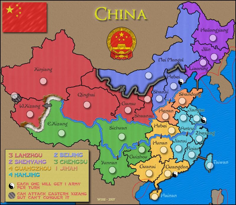
Q: What's the name of the territory that can bombard E. Xizang?
Edit: Ah, found where it is named "Chinese Kashmir". See S4.
S1: When I looked at the map and legend, I at first thought that the small stripped territory could bombard Xinjiang. It wasn't until I went to type the question above that I realized it bombards a green country. I think this could really use a visual aid, like a dashed-arrow or matching target symbols. (High priority - I think this will cause confusion to people who are unfamiliar with these names)
S2: What if you word the yin-yang explanation: "Each gets 1 army per turn"? I think this would fit on one line, and then you could add a piece of the Great Wall and label it (especially as it is somewhat difficult to see that it is a man-made wall on the small map). (Low priority - just aesthetic)
S3: I kind of like the log bridges myself, but as an alternative, if you made them a mottled grey and gave them a little arch they might look like stone bridges without much further change. (Low priority - just aesthetic)
S4:
Change last part of legend to read:
"(\\\) C. Kashmir can bombard E. Xizang but can't conquer it"
(If we start using consistent terminology across different maps for the new bombardment feature, it will be less confusing to people)
Then name the country "Chinese Kashmir" in the XML. (Med priority - I think actually naming a country "\\" in the XML will be confusing to people)
Posted: Sat Jun 09, 2007 7:47 pm
by AndyDufresne
Regarding the above post, I think
Suggestion 1 should be looked into definitely, as I didn't even realize until now that it attacked in green!
--Andy
Posted: Sun Jun 10, 2007 5:21 am
by Wisse
Sparqs wrote:Looks great! But I have a question and some suggestions:
Q: What's the name of the territory that can bombard E. Xizang?
Edit: Ah, found where it is named "Chinese Kashmir". See S4.
S1: When I looked at the map and legend, I at first thought that the small stripped territory could bombard Xinjiang. It wasn't until I went to type the question above that I realized it bombards a green country. I think this could really use a visual aid, like a dashed-arrow or matching target symbols. (High priority - I think this will cause confusion to people who are unfamiliar with these names)
S2: What if you word the yin-yang explanation: "Each gets 1 army per turn"? I think this would fit on one line, and then you could add a piece of the Great Wall and label it (especially as it is somewhat difficult to see that it is a man-made wall on the small map). (Low priority - just aesthetic)
S3: I kind of like the log bridges myself, but as an alternative, if you made them a mottled grey and gave them a little arch they might look like stone bridges without much further change. (Low priority - just aesthetic)
S4: Change last part of legend to read:
"(\\\) C. Kashmir can bombard E. Xizang but can't conquer it"
(If we start using consistent terminology across different maps for the new bombardment feature, it will be less confusing to people)
Then name the country "Chinese Kashmir" in the XML. (Med priority - I think actually naming a country "\\" in the XML will be confusing to people)
S1: no problem but i only will change something to the legend, but then everyone will understand what it means
S2: srry i don't understand, why needs the wall in the legend? everyone can see thats it is a non-crossable border (one way for gansu)
now i mention the one way, i fortgor the arrow at the mountains in the tiny version will update that, but can you explain why the wall must be in the legend?
S3: thanx for the suggestion that will help a lot
S4: great suggestion i will do that
So in the next update there will be this:
new bridges
change of legend (e.xizang change + C. Kashmir)
Posted: Sun Jun 10, 2007 5:33 am
by Sparqs
Wisse wrote:Sparqs wrote:S2: What if you word the yin-yang explanation: "Each gets 1 army per turn"? I think this would fit on one line, and then you could add a piece of the Great Wall and label it (especially as it is somewhat difficult to see that it is a man-made wall on the small map). (Low priority - just aesthetic)
S2: srry i don't understand, why needs the wall in the legend? everyone can see thats it is a non-crossable border (one way for gansu)
now i mention the one way, i fortgor the arrow at the mountains in the tiny version will update that, but can you explain why the wall must be in the legend?
Oh, it doesn't
need to be in the legend. This isn't a case of game-play confusion, I merely thought you might like a place to label the Great Wall, for flavor purposes. On the small map you can tell it's a barrier, but it's not as obvious exactly what it is.
Posted: Sun Jun 10, 2007 5:40 am
by Wisse
Sparqs wrote:Wisse wrote:Sparqs wrote:S2: What if you word the yin-yang explanation: "Each gets 1 army per turn"? I think this would fit on one line, and then you could add a piece of the Great Wall and label it (especially as it is somewhat difficult to see that it is a man-made wall on the small map). (Low priority - just aesthetic)
S2: srry i don't understand, why needs the wall in the legend? everyone can see thats it is a non-crossable border (one way for gansu)
now i mention the one way, i fortgor the arrow at the mountains in the tiny version will update that, but can you explain why the wall must be in the legend?
Oh, it doesn't
need to be in the legend. This isn't a case of game-play confusion, I merely thought you might like a place to label the Great Wall, for flavor purposes. On the small map you can tell it's a barrier, but it's not as obvious exactly what it is.
ah ok i can try if it looks good
Posted: Sun Jun 10, 2007 6:03 am
by gimil
This isnt a big thing but i thing the terr names on the ocean need an outline. the other terr naems which lie half and half on the ocean have them. i just feel it'll help them fit a little better.
Also the terr thats not in a continent has an uneven border on it on teh north east boarder.
other than that im happy with this map
Posted: Sun Jun 10, 2007 6:06 am
by Wisse
gimil wrote:This isnt a big thing but i thing the terr names on the ocean need an outline. the other terr naems which lie half and half on the ocean have them. i just feel it'll help them fit a little better.
Also the terr thats not in a continent has an uneven border on it on teh north east boarder.
other than that im happy with this map
that didn't look good but mayby i can try something i have something on my mind
Posted: Sun Jun 10, 2007 6:10 am
by gimil
maby if u make those names black with the light blue boarder. i think that should do it
Posted: Sun Jun 10, 2007 6:45 am
by Wisse
gimil wrote:maby if u make those names black with the light blue boarder. i think that should do it
thats not it, its more that the borders are pixely but i know something i hope