Page 15 of 28
Posted: Sat Feb 23, 2008 10:34 pm
by gimil
My advise would be to remove the "+" signs rather than give yourself more work needless work to make them more clear

Posted: Sat Feb 23, 2008 10:37 pm
by rgbubba
gimil wrote:My advise would be to remove the "+" signs rather than give yourself more work needless work to make them more clear
No problem!
Posted: Sun Feb 24, 2008 12:33 am
by rgbubba
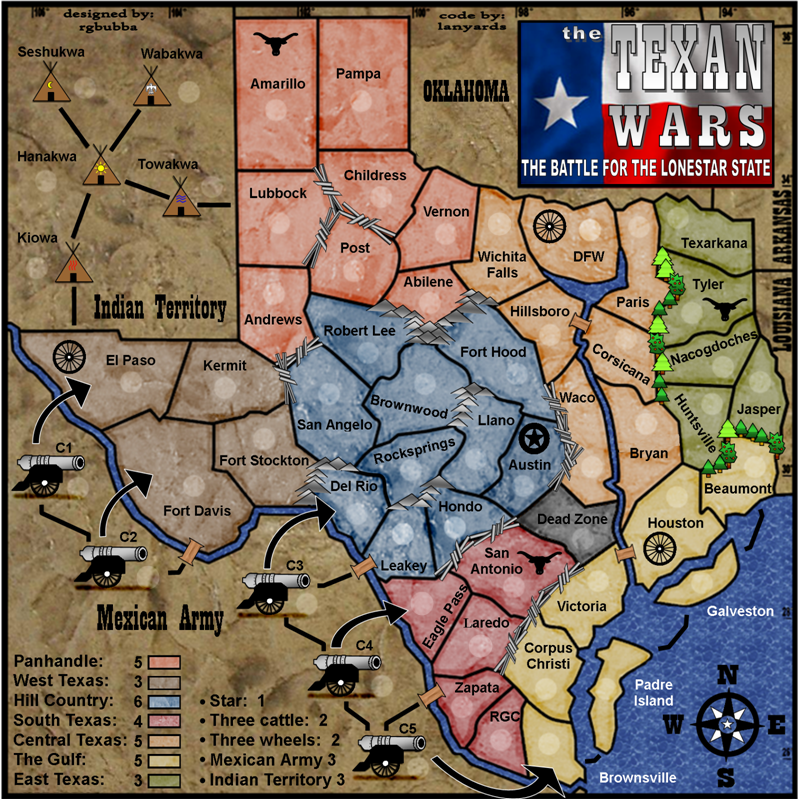
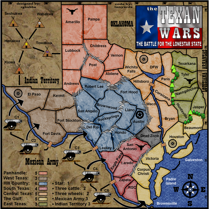
"+ removed"
600x600
800x800
Posted: Sun Feb 24, 2008 12:50 am
by tenio
it might be too late but the font under MEXICO is kindof hard for me to read
Posted: Sun Feb 24, 2008 1:07 am
by rgbubba
tenio wrote:it might be too late but the font under MEXICO is kindof hard for me to read
In what way? Please describe!
Posted: Sun Feb 24, 2008 2:36 pm
by tenio
from a pm
it is a little too blocky
it kind of blends together in my eyes
Posted: Sun Feb 24, 2008 6:12 pm
by laci_mae
Glad you removed the + signs. The legend is much easier on the eyes. I agree that the font under Mexico could stand for a small increase in kerning.
I'm really excited for you guys to finish this map up. I bet it's awesome to get down to the last few minor adjustments!
Best,
Laci
Posted: Sun Feb 24, 2008 6:57 pm
by edbeard
I don't think some of your instructions are necessary.
I'd remove everything from Dead Zone: no bonus down
Posted: Sun Feb 24, 2008 7:24 pm
by laci_mae
edbeard wrote:I don't think some of your instructions are necessary.
I'd remove everything from Dead Zone: no bonus down
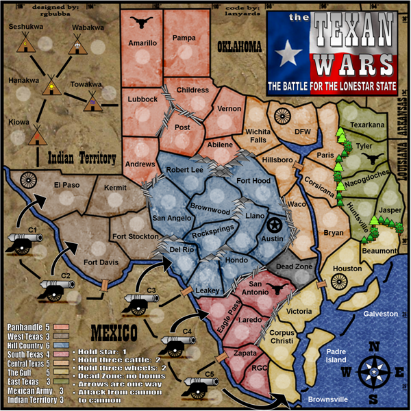
I agree, and this would allow you to space out the other directions so they will be more readable! Stating "hold . . . " is also redundant.
Possibly you could have these directions:
Left column
Panhandle 5 down to East Texas 3
Right column
Mexican Army 3
Indian Territory 3
Star 1
Three Cattle 3
Three Wheels 3
Dead Zone No Bonus
Finally, what exactly does "Dead Zone: No Bonus" mean? My first impression is that it means you don't get any bonuses at all if you hold that territory. If this is the case you might want to say "Negates all bonuses" instead of "No Bonus".
Hope this helps.
Best,
LMR[/u]
Posted: Sun Feb 24, 2008 11:38 pm
by snapdoodle
If he removes the attack from cannon to cannon line he will need to add a connector from c2 to c3. Unless that line is wrong anyway. In which case it definately needs removing.
Posted: Mon Feb 25, 2008 12:57 am
by laci_mae
snapdoodle wrote:If he removes the attack from cannon to cannon line he will need to add a connector from c2 to c3. Unless that line is wrong anyway. In which case it definately needs removing.
C2 has an arrow and a bridge that go to the same territory. Possibly the bridge should be removed and converted into a connector line to C3. However, the C2 bridge is the only way to get to the cannons from West Texas.
Time for an executive decision!!
LMR
Posted: Mon Feb 25, 2008 1:23 am
by rgbubba
snapdoodle wrote:If he removes the attack from cannon to cannon line he will need to add a connector from c2 to c3. Unless that line is wrong anyway. In which case it definately needs removing.
I just wanted to make sure that it's understood that you can not attack from the way you came in. I guest I could make more arrows to cannons. Maybe we need to see what Gimil will say. I do agree to a point.
Thank guys for your contiuned support. I need it.
Posted: Mon Feb 25, 2008 1:19 pm
by cisco2001
You need to label the Mexican army on the map. Also, you need to reference "impassables" in the key. i.e. trees, barbed wire, water, etc. Finally, the cattle are really Longhorns; so call them what they are. Other than those things, the map is great I can't wait to play it. You're getting my seal of approval and I'm a die hard native Texan!
Cisco2001
Posted: Mon Feb 25, 2008 2:34 pm
by FreeMan10
I dunno, the bridges, lines & arrows all made sense to me. The cannons shoot at the land masses, they can attack each other, and if you're tired of getting blasted by the blasted things, you can fight back by crossing the Rio Grande without having to swim.
Posted: Sat Mar 01, 2008 4:04 pm
by gimil
rgbubba can you please put all your stamps in the first post and tag you title with hte stamps you have.
Posted: Sat Mar 01, 2008 4:21 pm
by Kaplowitz
why dont you just do it for him gimil? You're a mod.
Posted: Sat Mar 01, 2008 4:46 pm
by gimil
Kaplowitz wrote:why dont you just do it for him gimil? You're a mod.
Because if I do it for one I have to do it for all. It was alright when I was starting up the tagging but now im encouraging everyone to self moerate the little things.
Posted: Sun Mar 02, 2008 12:06 am
by rgbubba
gimil wrote:rgbubba can you please put all your stamps in the first post and tag you title with hte stamps you have.
Sorry I had not been around. I been working on other art projects.
Yes sir I will. Give me time to look for all of them.
Posted: Sun Mar 02, 2008 4:33 am
by Elijah S
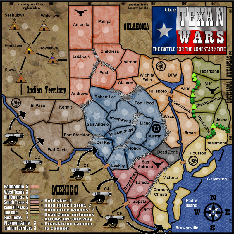
The only thing I dislike about this map is the bridges look like spools of thread and the attack lines from the Indian territories should go all the way to the place where they can attack.
The one leading from Ft. Davis to C2 should end closer to the cannon.
Otherwise, a good looking map which should be a lot of fun to play!
Posted: Sun Mar 02, 2008 12:42 pm
by rgbubba
Elijah S wrote:The only thing I dislike about this map is the bridges look like spools of thread and the attack lines from the Indian territories should go all the way to the place where they can attack.
The one leading from Ft. Davis to C2 should end closer to the cannon.
Otherwise, a good looking map which should be a lot of fun to play!
Thanks for look out for problem areas. I will work on it.
Posted: Sun Mar 02, 2008 7:29 pm
by laci_mae
Great job updating the legend. It's much more parsimonious and understandable.
I agree with Elijah that the bridges do look like thread spools, but they are obviously bridges. However, I believe the attack lines in Indian Territory are fine.
I think the presentation of the attack routes to, from, and between the cannons still needs some discussion. It currently appears that they can only attack inward and to the left and right. The lines should be adjusted if it is meant for all the cannons to be able to attack each other. Also, the line AND arrow from C2 go to Fort Davis. This is redundant. One could be removed to allow room for the line that is needed between C2 and C3.
Posted: Mon Mar 03, 2008 1:01 am
by rgbubba
laci_mae wrote:Great job updating the legend. It's much more parsimonious and understandable.
I agree with Elijah that the bridges do look like thread spools, but they are obviously bridges. However, I believe the attack lines in Indian Territory are fine.
I think the presentation of the attack routes to, from, and between the cannons still needs some discussion. It currently appears that they can only attack inward and to the left and right. The lines should be adjusted if it is meant for all the cannons to be able to attack each other. Also, the line AND arrow from C2 go to Fort Davis. This is redundant. One could be removed to allow room for the line that is needed between C2 and C3.
Yes I know that there is no line to C2 to C3. I took a part from Pearl Harber where planes are divided in to sections not all are connected. But if you think It needs it I will put it in.
Posted: Mon Mar 03, 2008 12:38 pm
by musicman_379
This map, with the current texture, can eaisly do without the army cirlces. If you want to use the army circles, I suggest you give them more opacity--currently, they kind of just 'disappear' into the texture.
Posted: Mon Mar 03, 2008 1:13 pm
by gimil
Im only seeing minor nitpicking being discussed here.
So have these:


But remeber this doesnt mean you can ignore any graphical issues that come up