Page 12 of 28
Posted: Sun Feb 03, 2008 11:47 am
by rgbubba
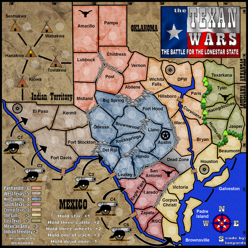
What do you think about the map without Tee-pees and Cannons?
___________________________________________________
I would like your input! Witch one do you like best and have better game play?
rgbubba
TEXAN WARS (FINAL FORGE)
Posted: Sun Feb 03, 2008 11:49 am
by pepperonibread
rgbubba wrote:What do you think about the map without Tee-pees and Cannons?
I vote keep them.
Posted: Sun Feb 03, 2008 1:04 pm
by DiM
pepperonibread wrote:rgbubba wrote:What do you think about the map without Tee-pees and Cannons?
I vote keep them.
me too. i like them.
Posted: Sun Feb 03, 2008 1:04 pm
by Lone.prophet
ok since you asked nicely

1. the colors llok to much like each other which makes the legend not clear and can cause confusing for people with lesser eyesight
2. I dont like the capital like bonus but thats just me (bull wheel and star)
3. the flag doesnt fit in maybe make it a bit curly, or give it some distort
4. the grades or whatever dont suit well if you aint gonna give a grid.
5. the army circles, (i prefer them lighter as the rest of the map but thats no concern) arent they a bit small?
the gameplay looks good though i would love to play this
Posted: Sun Feb 03, 2008 1:09 pm
by pepperonibread
The flag looks fine to me. Everything else on the map is so straight, I don't think a rippling flag would go well with the image. You could try it though.
Posted: Sun Feb 03, 2008 1:10 pm
by DiM
other thoughts
1. the army circles look a bit strange. perhaps make them like the army circles in d-day. i think those would fit better.
2. the tree colour is too bright, desaturate it a bit
3. make a -1 decay on the dead zone because that's a very important place.
4. make the bridges wooden
Posted: Sun Feb 03, 2008 1:12 pm
by rgbubba
Thanks guys for you comments. I will try to make the changes you guys suggested.
Posted: Sun Feb 03, 2008 1:19 pm
by Lone.prophet
pepperonibread wrote:The flag looks fine to me. Everything else on the map is so straight, I don't think a rippling flag would go well with the image. You could try it though.
the straight flag doesnt fit the texture IMO
Posted: Sun Feb 03, 2008 1:32 pm
by rgbubba
BONUS POINTS ARE THEY TO HIGH?
Posted: Sun Feb 03, 2008 4:13 pm
by DiM
rgbubba wrote:BONUS POINTS ARE THEY TO HIGH?
i like them as they are.
New Update!
Posted: Sun Feb 10, 2008 3:24 pm
by rgbubba
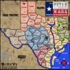
600x600 with lighter circles and wooden bridges
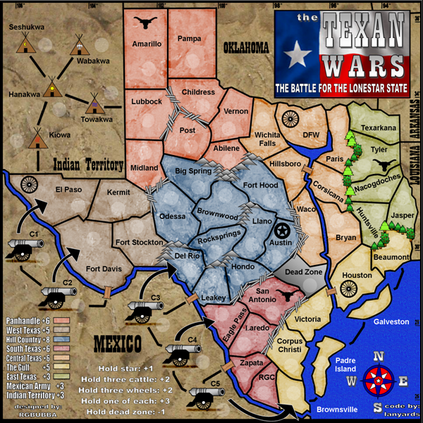
800x800 with lighter circles and wooden bridges
Posted: Sun Feb 10, 2008 3:29 pm
by DiM
i like it. the flag looks great.
could you also post the xml test with army numbers?
one thing i don't like is the black border around the map. especially since in the large one side has no border while another has a very thick one
Posted: Sun Feb 10, 2008 3:31 pm
by gimil
Leaky and DFW are missing army circles. I also noticed that the colorblind issues oaktown addressed hasnt been issued.
Posted: Sun Feb 10, 2008 3:34 pm
by DiM
gimil wrote:Leaky and DFW are missing army circles.
no they aren't. they both have circles. you're going blind now?

Posted: Sun Feb 10, 2008 3:41 pm
by gimil
DiM wrote:gimil wrote:Leaky and DFW are missing army circles.
no they aren't. they both have circles. you're going blind now?
well there horribly difficult to see

Posted: Sun Feb 10, 2008 4:06 pm
by WidowMakers
The large map looks a little blurry. Did you just scale up the small one?
WM
Posted: Mon Feb 11, 2008 12:40 am
by oaktown
blurry indeed.
Sorry I've been away for a few days - I'll try to give this map some attention this week.
Colorblind issue: if you could play with the color of East Texas we might be able to knock this problem out... i find East, Central, and Gulf Coast difficult to distinguish.
What exactly is central about Central Texas?

Posted: Mon Feb 11, 2008 8:52 am
by Wisse
the digits at the top and at the right side of the map aren't readable (on the small map)
Posted: Mon Feb 11, 2008 8:53 pm
by rgbubba
Thanks guys! I will sort out the problems as soon as I can!
Posted: Mon Feb 11, 2008 11:25 pm
by rgbubba
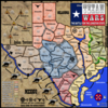
With Border fixed, circle darken abd East Texas darken
600X600 darker East Texas

800x800 darker East Texas
Posted: Mon Feb 11, 2008 11:27 pm
by rgbubba
oaktown wrote:blurry indeed.
Sorry I've been away for a few days - I'll try to give this map some attention this week.
Colorblind issue: if you could play with the color of East Texas we might be able to knock this problem out... i find East, Central, and Gulf Coast difficult to distinguish.
What exactly is central about Central Texas?
Yes I know that looks fun but it's true. They call it Central Texas. I have lived here most of my life and I still don't know why.
Posted: Tue Feb 12, 2008 12:17 am
by cazmart
Map looks good - can't wait to play.............
but since I am from texas also and live in Midland - the geographical stuff bugs me - i have not went through the rest of the posts so i do not know if this has been brought up -
Midland would be better as Andrews
Odessa better as San Angelo(especially if that is going to be Hill Country)
Big spring is also definitely not hill country but west texas -
Since I live in this area (raised in Big Spring - Lived in Midland for 10years - 40years total in this area) I guess that is why those bother me the most -
I know you are limited by borders and such but I also feel that it needs to be closer to truth (Midland is between Odessa and Big Spring) than the way it is even if that means i lose my beloved Midland!
Posted: Tue Feb 12, 2008 12:35 am
by rgbubba
cazmart wrote:Map looks good - can't wait to play.............
but since I am from texas also and live in Midland - the geographical stuff bugs me - i have not went through the rest of the posts so i do not know if this has been brought up -
Midland would be better as Andrews
Odessa better as San Angelo(especially if that is going to be Hill Country)
Big spring is also definitely not hill country but west texas -
Since I live in this area (raised in Big Spring - Lived in Midland for 10years - 40years total in this area) I guess that is why those bother me the most -
I know you are limited by borders and such but I also feel that it needs to be closer to truth (Midland is between Odessa and Big Spring) than the way it is even if that means i lose my beloved Midland!
Thanks for bring up this issue. I have looked into it and have changed that area serval time for other people. I have overlaid many maps to make sure it's as close as it can get. I have friends in those area as well and have been over there many times. Let me think about it and I'll get back to you . But in the meantime you can see the latess post on page 29 or 30.
Posted: Tue Feb 12, 2008 12:46 am
by rgbubba
btownmeggy wrote:What map is this? New Boston is farther east than Mt. Pleasant.

Here is one of the maps I used from other helpful contributers
Posted: Tue Feb 12, 2008 1:17 am
by rgbubba
cazmart wrote:Map looks good - can't wait to play.............
but since I am from texas also and live in Midland - the geographical stuff bugs me - i have not went through the rest of the posts so i do not know if this has been brought up -
Midland would be better as Andrews
Odessa better as San Angelo(especially if that is going to be Hill Country)
Big spring is also definitely not hill country but west texas -
Since I live in this area (raised in Big Spring - Lived in Midland for 10years - 40years total in this area) I guess that is why those bother me the most -
I know you are limited by borders and such but I also feel that it needs to be closer to truth (Midland is between Odessa and Big Spring) than the way it is even if that means i lose my beloved Midland!
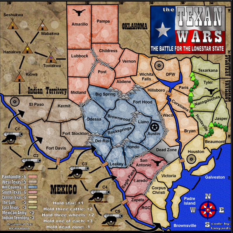
Here are the name changes on the map. Do you agree?
600x600 name change
800x800 name change
