Page 5 of 11
Re: Scandinavia - Rev VII - July 31 - Back on track
Posted: Thu Aug 07, 2008 8:52 am
by gimil
The Viking wrote:Isn't this ready for at least an idea stamp?
Once you reinstate a little comitment to the map then we'll see about an ideas stamp. For the time being ill be watching

Re: Scandinavia - Rev VIII - Aug 6 - Back on track
Posted: Thu Aug 07, 2008 2:04 pm
by CoolC
The Viking wrote:Have you considered allowing all Baltic Sea Islands to attack each other?
Yes, but i think it would make it too easy

Re: Scandinavia - Rev VIII - Aug 6 - Back on track
Posted: Thu Aug 07, 2008 3:09 pm
by The Viking
Yeah I though about that, but that would also make it a more desirable continent, right? Leading to more competition from players who might not have any territories near, say, Bornholm?
Re: Scandinavia - Rev VIII - Aug 6 - Back on track
Posted: Tue Aug 12, 2008 2:20 pm
by Lufsen75
Gotland are in the real life connected to Småland and Södermanland by boats. What I know Öland are not connected to gotland. Öland is connected to Småland, only.
Re: Scandinavia - Rev VIII - Aug 6 - Back on track
Posted: Tue Aug 12, 2008 2:56 pm
by Androidz
Tromsø is the right word as Viking said.
Another spelling mistake is:
More og Romsdal. But the real name is:
Møre og Romsdal
Re: Scandinavia - Rev VIIII - Aug 19
Posted: Tue Aug 19, 2008 1:19 pm
by CoolC
Lufsen: I thought it made more sense to have Öland connect to Gotland, it made a chain sort of... but now I've added a link between Småland and Gotland as well. Leaving the connection to Öland since it's reasonable to assume boats can go between the islands...
Regarding the names I've changed to Møre og Romsdal but I insist that Troms is the correct name, for the region. Tromsø is the name of the city. References:
http://sv.wikipedia.org/wiki/Norges_fylkenhttp://no.wikipedia.org/wiki/Norges_fylkerhttp://no.wikipedia.org/wiki/TromsBesides the name and connections mentioned the other changes in version 9 is removal of compass and improval of north arrow and another adjustment of brightness and contrast.
I may reconsider having all islands attack eachother, but I'm not convinced yet...
Re: Scandinavia - Rev VIIII - Aug 19
Posted: Tue Aug 19, 2008 1:41 pm
by Androidz
CoolC wrote:Lufsen: I thought it made more sense to have Öland connect to Gotland, it made a chain sort of... but now I've added a link between Småland and Gotland as well. Leaving the connection to Öland since it's reasonable to assume boats can go between the islands...
Regarding the names I've changed to Møre og Romsdal but I insist that Troms is the correct name, for the region. Tromsø is the name of the city. References:
http://sv.wikipedia.org/wiki/Norges_fylkenhttp://no.wikipedia.org/wiki/Norges_fylkerhttp://no.wikipedia.org/wiki/TromsBesides the name and connections mentioned the other changes in version 9 is removal of compass and improval of north arrow and another adjustment of brightness and contrast.
I may reconsider having all islands attack eachother, but I'm not convinced yet...
Yeah my bad it is Troms:D ashamed i spelled that wrong:D. Anyway good you fixed the other.
Re: Scandinavia - Rev VIIII - Aug 19
Posted: Tue Aug 19, 2008 3:04 pm
by Lufsen75
CoolC wrote:Lufsen: I thought it made more sense to have Öland connect to Gotland, it made a chain sort of... but now I've added a link between Småland and Gotland as well. Leaving the connection to Öland since it's reasonable to assume boats can go between the islands...
Regarding the names I've changed to Møre og Romsdal but I insist that Troms is the correct name, for the region. Tromsø is the name of the city. References:
http://sv.wikipedia.org/wiki/Norges_fylkenhttp://no.wikipedia.org/wiki/Norges_fylkerhttp://no.wikipedia.org/wiki/TromsBesides the name and connections mentioned the other changes in version 9 is removal of compass and improval of north arrow and another adjustment of brightness and contrast.
I may reconsider having all islands attack eachother, but I'm not convinced yet...
I just tell you how it is in this area. But to make sense of map you can have it like that but if realistic it should be conected to Småland and Södermanland. But I rather see this map happen than not. And to play at it doesnt matter.
Re: Scandinavia - Rev VIIII - Aug 19
Posted: Tue Aug 19, 2008 9:38 pm
by edbeard
put up the picture for discussion purposes.
1. I can't tell with which continent Aland belongs. perhaps put the name above the army circle. It's a bit hard to see what the colour is beneath Fyn on the small map. Maybe try moving the circle and name so that the colour is revealed a bit more.
2. The different coloured ships confused me for a minute. How about a white sail for all of them?
3. Is there a big significance to the boats (baltic sea islands) and the umm Laponia. What are the Laponia anyway? what's that symbol? They just seem a bit strange.
I'm not sure how much they add to the gameplay but it's your map.
4. just out of curiosity, how much of this is based on real borders and areas?
Re: Scandinavia - Rev VIIII - Aug 19
Posted: Wed Aug 20, 2008 1:17 pm
by CoolC
edbeard wrote:1. I can't tell with which continent Aland belongs. perhaps put the name above the army circle. It's a bit hard to see what the colour is beneath Fyn on the small map. Maybe try moving the circle and name so that the colour is revealed a bit more.
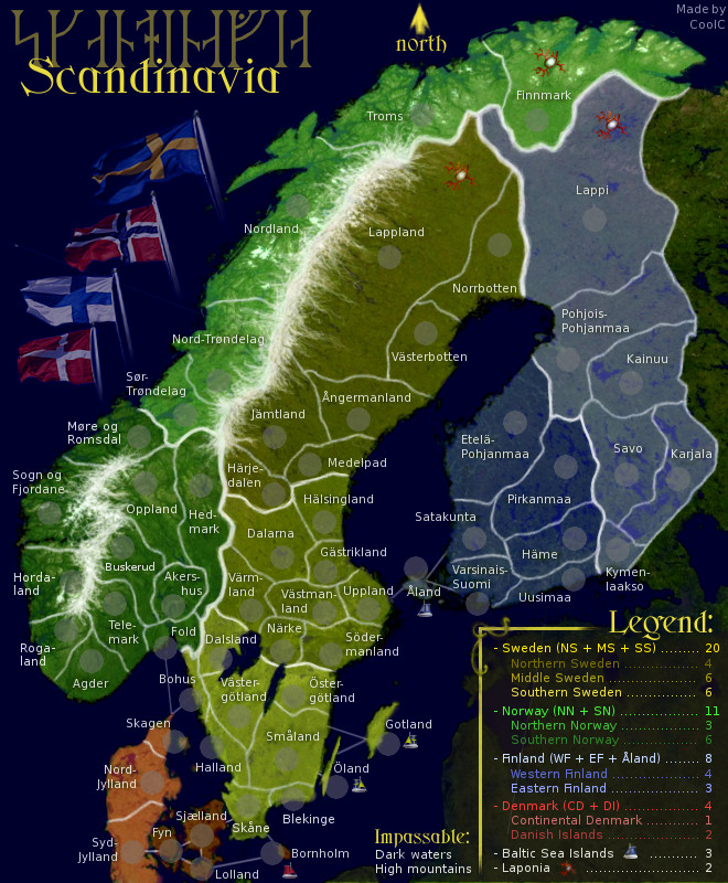
Åland belongs to Finland, but is not included in either western nor eastern finland, it's a free state but needed to gain the bonus for entire Finland. This is indicated in the legend but I will try to make it more clear on the map somehow, maybe color adjustment... This is also the case in reality btw. Åland is a self-governed part of Finland, only foreign affairs is handled by the finnish government (if i remember correct). I will also try to adjust the danish islands incl Fyn a bit more.
edbeard wrote:2. The different coloured ships confused me for a minute. How about a white sail for all of them?
I think there is a point in indicating that the islands/ships belong to different countries, but also are included in the island bonus. A ship is an indication of the place being a baltic sea island and it's sail indicate which country it belong to.
edbeard wrote:3. Is there a big significance to the boats (baltic sea islands) and the umm Laponia. What are the Laponia anyway? what's that symbol? They just seem a bit strange. I'm not sure how much they add to the gameplay but it's your map.
Well, the significance is that they are two extra bonus areas, nothing more or less really. I thought the map needed something more to spice it up then just the countries and their sub-parts and by creating competitive areas that belong to more then one bonus area it's set up for fighting
. To hold the baltic sea islands you need to have territories from sweden, finland and denmark - while the guy in southern sweden probably want his bonus as well.. I have based them on real areas but have considered changing the Laponia name for a while now, it's not fully geographically correct but I like it anyway. Laponia is a part of a large national park in northern Sweden and I took the name for a larger area since it's close enough and sounds nice. It's ment to indicate the Sami areas and the symbol is from an old ceremonial drum that belonged to a Sami shaman. As mentioned earlier in the thread maybe Troms and also Norrbotten should be included for realism but I wanted one area from each country, it created a nice symmetry.
If you want to know more about Sami click hereedbeard wrote:4. just out of curiosity, how much of this is based on real borders and areas?
Everything, with a few minor modifications. As I mentioned in the bottom of the first post (now modified):
The areas used are real existing ones with only a few exceptions: I have mashed together some east/west, south/north "double areas" like for example West Fold and East Fold. I have removed Oslo area because of space limitations. I also added Skagen as an area to raise the number in Denmark a bit. The areas used for Norway are in use today as secondary communes also known as "Fylken" while the areas selected for Sweden and Finland are the historic "Landskap" because that's what most swedes associate themselves with, rather then the new areas called "Län". In Finland the Landskap still have some official use. For Denmark I had to use just the main islands, again because of space limitations.
Re: Scandinavia - Rev VIIII - Aug 19
Posted: Mon Sep 08, 2008 5:22 am
by Tense
May we see armies on the army circles?
I have a feeling it will be hard (or a bit hard) to see blue on the dark blue sea as background. But I might be wrong.
/Tense
Re: Scandinavia - Rev VIIII - Aug 19
Posted: Mon Sep 08, 2008 5:59 am
by Androidz
Here's what i think you should fix:
In the legend denmark is red, now on the map orange. And that makes the legend inaccurate since you have the right colours for the other continents. So you must make the legend orange to when descripeing denmark.
Now i would like you to fix Akershus. Now you got Akers-hus, now it would be more accurate if you fixed to Aker-shus (since that what we say in norwegian) This is just a small problem.
i still think the darkwaters is so dark, why darkwaters? Why not light? Skandenavia is verry far north it would be more akkurate to have some icy look to it:S. But again no big problem.
Re: Scandinavia - Rev VIIII - Aug 19
Posted: Wed Sep 10, 2008 12:21 pm
by Lufsen75
Androidz wrote:Here's what i think you should fix:
In the legend denmark is red, now on the map orange. And that makes the legend inaccurate since you have the right colours for the other continents. So you must make the legend orange to when descripeing denmark.
I dont see that problem. Orange or red could still be called Red on the map.
Re: Scandinavia - Rev VIIII - Aug 19
Posted: Wed Sep 10, 2008 12:59 pm
by Androidz
Lufsen75 wrote:Androidz wrote:Here's what i think you should fix:
In the legend denmark is red, now on the map orange. And that makes the legend inaccurate since you have the right colours for the other continents. So you must make the legend orange to when descripeing denmark.
I dont see that problem. Orange or red could still be called Red on the map.
I don't know how it would look for colourblind but even tough its not accurate and stupid person might dont get it.
Re: Scandinavia - Rev VIIII - Aug 19
Posted: Thu Sep 11, 2008 3:30 pm
by MrBenn
This map looks very impressive, but I'm not sure if there is enough room for 3-digit army numbers in all the territories... have you checked this yet?
Re: Scandinavia - Rev VIIII - Aug 19
Posted: Fri Sep 12, 2008 5:38 pm
by MrBenn
... While I'm waiting for the check, this map's going to get stickied...
[Advanced Idea]
Re: Scandinavia - Rev VIIII - Aug 19
Posted: Sat Sep 13, 2008 6:50 pm
by CoolC
I will try to get a new version out in a few days, with army numbers. Have not tried three digits actually so that will be interesting.
Edit 23/9: Sorry, I got delayed by real life events... but now I'm almost done. This will be a larger update then the previous couple of ones.
Re: Scandinavia - Rev X
Posted: Tue Sep 30, 2008 10:46 pm
by CoolC
Sorry, again... I thought i would be getting it out tonight but the clock is ticking and it's not many hours left until work now

Changelog for version 8:
-Added a temporary compass to help decide if a compass in that place is better then the north-arrow
- Increased color coding / separation in legend (as per suggestion)
- Softened the boats a little bit
- Decided to increase the lightning but not as much as v. 7b
Changelog for version 9:
- Corrected name
- Added water border: Småland - Gotland
- Removed compass in favor of north-arrow
- Another adjustment of lightning (now at 25b, 29c)
And finally, the latest changelog for version 10:
- final touch on mountain range
- new font for most text (normalized, not very noticable change though)
- adjustment to Fyn and Åland (for edbeard)
- slight color change in legend for denmark (for androidz)
- verified 3 digit army numbers, but not included in image
Regarding the shortening for Åkershus I don't think there should be a change. We say Aker-shus in sweden as well but in writing it should be shortened Åkers-hus. The reason I have dark waters and not lighter ones is simply because that is the way the sat photo the map is based on was... also, lighter waters are smaller (passable) lakes and rivers. However, I will do a test with a new ocean look that may be included in next version. I am currently also experimenting a bit with borders, will probably make a few different variations to have you vote on later
Re: Scandinavia - Rev X
Posted: Fri Oct 03, 2008 6:55 pm
by CoolC
MrBenn wrote:This map looks very impressive, but I'm not sure if there is enough room for 3-digit army numbers in all the territories... have you checked this yet?
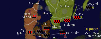
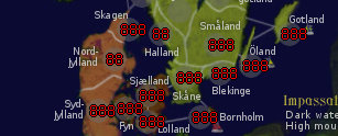
I've checked this now and 3 digits work fine everywhere on the large map except a slight overlapping of the boats on Öland and Gotland as well as the L in Lolland. I think this is acceptable considering how rarely it will be seen, but if it has to be fixed it's quite easily done. The small map also work fine in most places but besides the overlapping at Öland and Gotland there is a larger problem down in Denmark that I agree need to be fixed. I will deal with this in the next version. Here's how it looked during testing:
Large map:
Small map:
Re: Scandinavia - Rev X "the late one" - Oct 3
Posted: Sat Oct 04, 2008 2:53 pm
by MrBenn
Drafting Room Guidelines wrote:In order for a map to be stamped as having completed the "Draft" stage and moved on to the Main Foundry it must meet the following conditions:
- Relevant details should be summarised in the first post, including the name(s) of the individual(s) responsible for the creation of the map; and any information relevant to how this map will play, including (but not limited to) proposed starting neutral locations and values, victory conditions, unique play features, etc.
- Have a playable image (either large or small map) that fits within the size restrictions; It doesn't have to be perfect, but if the map were quenched today people should be able to play on it. The draft should include:
- territory names
- a working legend
- speculative bonuses
- tentative border divisions
- proposed impassable barriers
I am satisfied that this map meets all of the above criteria.

Welcome to the Foundry Proper... onwards and upwards
Mr B
Re: Scandinavia - Rev X "the late one" - Oct 3
Posted: Sat Oct 04, 2008 3:05 pm
by oaktown
MrBenn wrote:Welcome to the Foundry Proper... onwards and upwards
And let me be the first to congratulate you... unless I'm fast-posted.
I'll give this a more proper look later, but my first question is what is that thing that's identifying Laponia? Maybe something more attractive and easily identifiable can be found? Reindeer antlers?
Re: Scandinavia - Rev X "the late one" - Oct 3
Posted: Sun Oct 05, 2008 8:08 am
by CoolC
oaktown wrote:And let me be the first to congratulate you... unless I'm fast-posted.
I'll give this a more proper look later, but my first question is what is that thing that's identifying Laponia? Maybe something more attractive and easily identifiable can be found? Reindeer antlers?
Thank you!
I explained this on the previous page...
CoolC wrote:Laponia is a part of a large national park in northern Sweden and I took the name for a larger area since it's close enough and sounds nice. It's ment to indicate the Sami areas and the symbol is from an old ceremonial drum that belonged to a Sami shaman.
I wanted to include some of our old heritage as with the runes and thought the symbol was a good compliment. I can agree it's a fairly obscure symbol though so yeah, they might get replaced with antlers. That's also a good symbol
Re: Scandinavia - Rev VIIII - Aug 19
Posted: Thu Oct 09, 2008 3:22 am
by iancanton
CoolC wrote:I've added a link between Småland and Gotland
can u move the sea link slightly to the north, so that it is longer and therefore more visible? maybe u can angle it, so that the boat takes a diagonal path instead of going directly across by the shortest route.
CoolC wrote:I may reconsider having all islands attack eachother, but I'm not convinced yet...
i'm with u in keeping the existing sea routes, so that the islands link only to nearby places, meaning that the gameplay roughly matches the shape of the map and the sea keeps its status as a major impassable.
the current number of territories is 61. this is a bad size for the popular 2v2 (4-player doubles) game type: since each player starts with 15 territories, player 1 can immediately knock down player 2's deployment from 5 armies to 4 by taking just one territory from him or her. to reduce team 1's starting advantage, i strongly recommend that the map is reduced to 59 territories. sweden is the obvious place where we can merge territories without upsetting the look of the map, perhaps one in the north and one in the south.
ian.
Re: Scandinavia - Rev VIIII - Aug 19
Posted: Tue Oct 28, 2008 8:33 am
by Lufsen75
iancanton wrote:sweden is the obvious place where we can merge territories without upsetting the look of the map, perhaps one in the north and one in the south.
ian.
but you will upset the people that lives here.
Re: Scandinavia - Rev X "the late one" - Oct 3
Posted: Tue Oct 28, 2008 5:11 pm
by Ogrecrusher
Nice map, two comments. Is it just me that finds the flags odd? They look like they've been flipped to fit better
Also, Central Sweden would be a better name than Middle Sweden.