Page 1 of 1

Incan Empire

PostPosted: Thu Jun 28, 2007 12:35 am
by riggable
This is my second shot at a map, Based on the Terrain owned by the Incan Empire. If it is unclear, this is the western coast of South America.
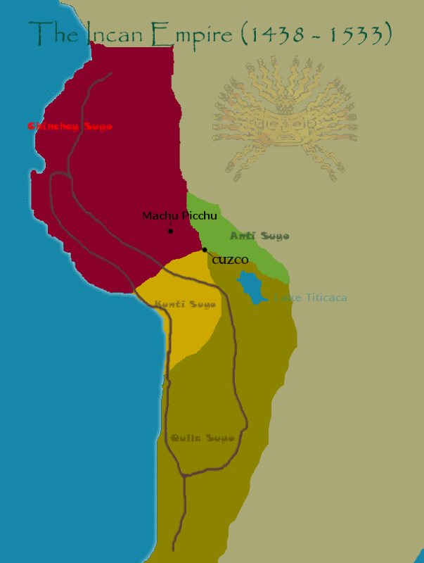
Image
The way the Incan Empire was set up is like so. There were 4 different regions, or Suyo's, The Chinchay, The Kunti, The Qulla, and The Anti. Each of these regions would meet in the middle at the capital of the Empire, Cuzco. I also showed Machu Picchu, the famous ruins of a city high up in the Andes mountains.
The Brown lines indicate the road system the Incans use, which was one of the highlights of the civilization. The incans built fabulous roads that could more than match the great roads of rome. The two i put in are just two of the main roads - there are many more. I would want to implement these roads into gameplay.

Here is where the problems begin:
-The Incan Empire, as you can see, was a very vertical empire. It went from northen to southern south america, but stayed near the coast. In order to creat a map like this, I would need to have a very tall(taller than it is right now) but relatively thin map.
-I've looked and looked, but besides those 4 major regions of the empire, I can find no map or text detailing smaller regions I could use as territories for this map, which is a big problem.


Any tips, ideas, or opinions on how I should continue this map would be awesome. If you can answer either of my problems or bring up more i havent thought of yet, I would greatly appreciate it. THanks.

PostPosted: Thu Jun 28, 2007 2:11 am
by gimil
teh height will eb a real problem you'll have to try and lay teh empire at an angle to get in to fit around the 800px height guidline.

PostPosted: Thu Jun 28, 2007 10:19 am
by sfhbballnut
its also very linear, which you might be able to overcome, river routes or inner territories or something, good start keep at it

PostPosted: Thu Jun 28, 2007 11:45 am
by RobinJ
This is a very good idea for a map but just don't let it turn into an "Indochina" style map

PostPosted: Thu Jun 28, 2007 12:31 pm
by thegeneralpublic
For naming, I'm sure you could get away with using modern day names for geographical features. Not cities, though. Also, you may want more than four territories, IE, North and South Qulla.

PostPosted: Thu Jun 28, 2007 3:59 pm
by KEYOGI
It's just my personal preference and opinion, but I'd much rather see an Aztec Empire map. I think it lends itself a bit better to a CC map and you can use a modern map of Mexico to fill in the blanks.

Image

PostPosted: Thu Jun 28, 2007 4:16 pm
by Evil Pope
Is it possible to find any more cities within the Empire?.. If you can, you could use cities rather than regions.. I think thats a viable alternative. And just divide the land among the cities.. or just have the cities themselves as the territories and connect them all through roads or attack routes. That is if you can find details such as that.. I would expect it to be easier. But maybe not.

http://www.crystalinks.com/incan.html
There's a map on there.. I only checked a few cities listed, but they seem to mostly be cities exsisting during the time of the Incan Empire, so most of them should be usable if you think this is a workable idea..

PostPosted: Thu Jun 28, 2007 4:55 pm
by unriggable
Very, very top-bottom.

PostPosted: Thu Jun 28, 2007 6:13 pm
by Evil Pope
Yeah, thats a problem.. Yet, maybe you could try to implement the roads in a way that would lessen that problem just a bit. I don't know how, but I think that could help. Not sure about water transport, but if the Incas did use it you could connect citys by the ocean too.. Maybe find more cities.. I'm sure with enough it wont be as much of a problem as long as there isn't a severe bottleneck like in the indochina map.

PostPosted: Thu Jun 28, 2007 8:08 pm
by unriggable
Look at the texan wars map, try using the railroads idea in there (also look at the d-day map and the trenches, same idea).

PostPosted: Thu Jun 28, 2007 9:06 pm
by thegeneralpublic
unriggable wrote:Look at the texan wars map, try using the railroads idea in there (also look at the d-day map and the trenches, same idea).

Drat, he beat me to that. I thought about that as soon as I read the post above him. That would be a good application of the roads; if you could find some major Incan cities along the roads, they could attack each other without passing through the territories in between.

PostPosted: Thu Jun 28, 2007 11:12 pm
by riggable
all good ideas. THanks for the map pope. I'll get on this as soon as I can.

PostPosted: Thu Jun 28, 2007 11:13 pm
by riggable
KEYOGI wrote:It's just my personal preference and opinion, but I'd much rather see an Aztec Empire map. I think it lends itself a bit better to a CC map and you can use a modern map of Mexico to fill in the blanks.

Image


That would be the map i would tackle next. I just feel a bit connected to the incan empire because I was born in Peru.

PostPosted: Fri Jun 29, 2007 12:22 am
by KEYOGI
Fair enough. If your Incan Empire map continues to develop, I'd suggest rotating the map anywhere up to 45 degrees to give yourself some more room to work with. 8)

PostPosted: Fri Jun 29, 2007 1:18 am
by riggable
I reworked the map so that its angled 45 degrees right and 45 degrees left. Which looks better? Personally I think the one that goes to the right is better.
Image
To the right.
Image
To the left.

Obviously these two are just for aesthetic purposes - i want to find out which angle looks better before i begin redrawing.

PostPosted: Fri Jun 29, 2007 2:54 am
by KEYOGI
Did rotating actually make any difference? It seems roughly the same size anyway. :?

PostPosted: Fri Jun 29, 2007 11:48 am
by thegeneralpublic
I think the left rotation would be perfect for the map's layout, as well as making the area more immediately recognizable. However, the bottleneck problem is still going to be there. What did you think about the road idea?

PostPosted: Fri Jun 29, 2007 1:53 pm
by riggable
KEYOGI wrote:Did rotating actually make any difference? It seems roughly the same size anyway. :?

When I rotated them i could enlarge the map greatly. I will resize the Regions to make them more accurate and hopefully there will be signifigantly more space to work with.

thegeneralpublic wrote:I think the left rotation would be perfect for the map's layout, as well as making the area more immediately recognizable. However, the bottleneck problem is still going to be there. What did you think about the road idea?

Image
This is a map i found Detailling all the major roads in the Incan Empire. Obviously I cant put in all of them - there are too many. Along with the nice map Evil Pope gave me, I'll start trying to widdle down the amount roads to get the ones which are most essential.

PostPosted: Fri Jun 29, 2007 8:44 pm
by thegeneralpublic
I actaully liked what you had last time...any more than that and it could get redundant, unless you have a LOT of territories.