Some Good Ideas
I'm posting my ideas in a different thread then the "Ideas free to a good home" strand because that one needs to be cleaned up and has turned into a lot of chat and not as many ideas.
Here some maps that I would love to see on here
************************************************
MEXICO MAP
http://www.conquerclub.com/forum/viewtopic.php?t=14824
I free handed the state borders and posted it up to try to inspire some good designers to run with it.
*************************************************
MAP OF POLYNESIA
*if you do this map, please understand that the Philippines are not part of Polynesia, but are a part of Asia which is a common misconception. (Wikipedia) Here is a list of what countries fall under the category of being Polynesian.
* American Samoa (overseas United States territory)
* Anuta (in the Solomon Islands)
* Cook Islands (self-governing state in free association with New Zealand)
* Easter Island (part of Chile, called Rapa Nui in Rapa Nui)
* Emae (in Vanuatu)
* French Polynesia ("overseas country", a territory of France)
* Hawai‘i (a state of the United States)
* Kapingamarangi (in the Federated States of Micronesia)
* Loyalty Islands (a dependency of the French territory of New Caledonia)
* Mele (in Vanuatu)
* New Zealand (called Aotearoa in Māori, usually associated with Australasia)
* Niue (self-governing state in free association with New Zealand)
* Nuguria (in Papua New Guinea)
* Nukumanu (in Papua New Guinea)
* Nukuoro (in the Federated States of Micronesia)
* Ontong Java (in the Solomon Islands)
* Pileni (in the Solomon Islands)
* Rennell (in the Solomon Islands)
* Rotuma (in Fiji)
* Samoa (independent nation)
* Sikaiana (in the Solomon Islands)
* Swains Island (politically part of American Samoa)
* Takuu (in Papua New Guinea)
* Tikopia (in the Solomon Islands)
* Tokelau (overseas dependency of New Zealand)
* Tonga (independent nation)
* Tuvalu (independent nation)
* Wallis and Futuna (overseas territory of France)
*******************************************************
SEATTLE MAP
Like New York and San Francisco, Seattle is broken up into a handful of Burroughs/Districts. With the Puget Sound and Lake Union right in the middle of it, it makes for as good of a City Map as the San Francisco Map that is being worked on right now.
Seattle Burroughs
Capital Hill
Queen Anne
Fremont
Ballard
U-District
Belltown
Magnolia
Wallingford
West Seattle
Madrona
Green Lake
Montlake
Pioneer Square
Beacon hill
Mt. Baker
International District
SoDo (South Downtown)
Crown Hill
Shoreline
Interbay
Phinney Ridge
Loyal Heights
Ravenna
You can use the fairies and bridges to get to Bainbridge Island and Bremerton
***************************************************
MARCH MADNESS MAP
for all you basketball nuts. With the brackets and seeds, there has to be something that would make a logical map.
***************************************************
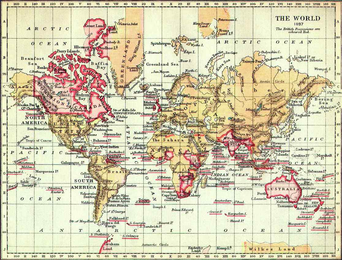
BRITISH EMPIRE MAP
"The sun never sets on the British Empire"
A map of the British Empire pre-WWII. It would be interesting to see a world map based upon conquering the pre-WWII British Empire.
****************************************************
If anyone is already working on these maps, you rock and sorry for not noticing. I wish I had some Graphic design skills but at least I have some good suggestions. At least I think I do

Here some maps that I would love to see on here
************************************************
MEXICO MAP
http://www.conquerclub.com/forum/viewtopic.php?t=14824
I free handed the state borders and posted it up to try to inspire some good designers to run with it.
*************************************************
MAP OF POLYNESIA
*if you do this map, please understand that the Philippines are not part of Polynesia, but are a part of Asia which is a common misconception. (Wikipedia) Here is a list of what countries fall under the category of being Polynesian.
* American Samoa (overseas United States territory)
* Anuta (in the Solomon Islands)
* Cook Islands (self-governing state in free association with New Zealand)
* Easter Island (part of Chile, called Rapa Nui in Rapa Nui)
* Emae (in Vanuatu)
* French Polynesia ("overseas country", a territory of France)
* Hawai‘i (a state of the United States)
* Kapingamarangi (in the Federated States of Micronesia)
* Loyalty Islands (a dependency of the French territory of New Caledonia)
* Mele (in Vanuatu)
* New Zealand (called Aotearoa in Māori, usually associated with Australasia)
* Niue (self-governing state in free association with New Zealand)
* Nuguria (in Papua New Guinea)
* Nukumanu (in Papua New Guinea)
* Nukuoro (in the Federated States of Micronesia)
* Ontong Java (in the Solomon Islands)
* Pileni (in the Solomon Islands)
* Rennell (in the Solomon Islands)
* Rotuma (in Fiji)
* Samoa (independent nation)
* Sikaiana (in the Solomon Islands)
* Swains Island (politically part of American Samoa)
* Takuu (in Papua New Guinea)
* Tikopia (in the Solomon Islands)
* Tokelau (overseas dependency of New Zealand)
* Tonga (independent nation)
* Tuvalu (independent nation)
* Wallis and Futuna (overseas territory of France)
*******************************************************
SEATTLE MAP
Like New York and San Francisco, Seattle is broken up into a handful of Burroughs/Districts. With the Puget Sound and Lake Union right in the middle of it, it makes for as good of a City Map as the San Francisco Map that is being worked on right now.
Seattle Burroughs
Capital Hill
Queen Anne
Fremont
Ballard
U-District
Belltown
Magnolia
Wallingford
West Seattle
Madrona
Green Lake
Montlake
Pioneer Square
Beacon hill
Mt. Baker
International District
SoDo (South Downtown)
Crown Hill
Shoreline
Interbay
Phinney Ridge
Loyal Heights
Ravenna
You can use the fairies and bridges to get to Bainbridge Island and Bremerton
***************************************************
MARCH MADNESS MAP
for all you basketball nuts. With the brackets and seeds, there has to be something that would make a logical map.
***************************************************
BRITISH EMPIRE MAP
"The sun never sets on the British Empire"
A map of the British Empire pre-WWII. It would be interesting to see a world map based upon conquering the pre-WWII British Empire.
****************************************************
If anyone is already working on these maps, you rock and sorry for not noticing. I wish I had some Graphic design skills but at least I have some good suggestions. At least I think I do