Page 1 of 1

Virginia- The Old Dominion

PostPosted: Tue May 25, 2010 12:47 pm
by b00kw0rm
I think we need a map of Virginia. Why? Several reasons.

1. Virginia was the site of the first permanent English settlement.
2. It was also the first colonial capital in the colonies.
3. More Presidents have come from Virginia than any other state.
4. The US Constitution was modeled after the Virginia constitution.
5. Most of the battles of the US Civil War were fought in Virginia.

Here's a county map that I recolored for simple bonus regions.

Image

It will have to lose a lot of counties unless we want another massive map.

Re: Virginia- The Old Dominion

PostPosted: Tue May 25, 2010 12:49 pm
by skello496
I suggest combining some of the smallest counties, (leave purple whole) especially in blue. Put an impassable barrier on the Mountain ranges. make Richmond and make that be a bonus. Make the Chesapeake Bay holdable maybe.

Re: Virginia- The Old Dominion

PostPosted: Tue May 25, 2010 3:12 pm
by MarshalNey
b00kw0rm wrote:I think we need a map of Virginia. Why? Several reasons.

1. Virginia was the site of the first permanent English settlement.
2. It was also the first colonial capital in the colonies.
3. More Presidents have come from Virginia than any other state.
4. The US Constitution was modeled after the Virginia constitution.
5. Most of the battles of the US Civil War were fought in Virginia.


As a student of American History, I must protest the usage of the word "most" in #5. It implies that over 50% of the battles of the Civil War were fought in Virginia, which is not correct. What is correct is that Virigina had more 'military engagements' than any other state during the Civil War (incidentally, Missouri is 3rd).

That said, is your map going to incorporate any of these interesting historical items?

Re: Virginia- The Old Dominion

PostPosted: Tue May 25, 2010 3:54 pm
by b00kw0rm
Thanks for pointing out that error, you're right, it should say "more than any other state" instead of "most".

And yes, I was thinking about having bonuses for historical sites. Williamsburg (first colonial capital) and Jamestown (first permanent English settlement) would be held for a bonus, as well as the homes of each of the Virginian Founding Fathers (Monticello, Montpelier, Mount Vernon, etc)
Holding major CW battlefields (Fredericksburg, Chancellorsville, Richmond, Cold Harbor, etc) could be held for a bonus. CW bonus, Historical Home Bonus, Capital Bonus, etc

Re: Virginia- The Old Dominion

PostPosted: Tue May 25, 2010 4:42 pm
by jrh_cardinal
lol, as a VA resident I like this idea :)

Several suggestions:
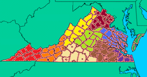
1 Northern VA: Northern VA is INCREDIBLY different than the rest of VA. Northern Virginia is mostly just Fairfax and Loudon Counties, the two big ones at the top of the dark red bonus. I would say make this its own small bonus. If you want to incorporate the historical sites, you also might want to blow up that region (see WWII Europe, several other maps) because a lot of Civil War stuff is there.

2 Impassables: definitely have Mountains between the orange/yellow regions and the whitish/light green/ a little bit of dark red regions. You can have 1 or 2 holes in the mountains if you want, but they're necessary to decrease all of the borders for all of the regions, etc. I would also have the rivers come pretty far in as impassables. Right now the whole map is just too clumped together.

3 Tert Count: I agree with one of the other posters, too many small counties in the light blue region. Remember, troop counts and region names have to go on these. To decrease the number of terts I would also say to clump all of the purple counties into 1 or 2 terts and merge that bonus with some of the Brown terts as 1 bigger Tidewater Region Bonus. There are around 100 (I think 90something) counties in Virginia. I don't think a map like this should have more than like 50-60 (this is just my opinion). So you're gonna have a lot of merging to do if you take it down that far.

4 Peninsula: obviously you need to figure out where you're gonna connect the peninsula terts, I don't like the idea of having the water as a tert, but that's up to you. I think you should just have lines connecting them like classic, or many other maps.

Regions (not all are great names, but I figured I'd try to think of a list to start):
Yellow: Shenandoah
Dark Red: NoVA (Northern Virginia)
Blue: Chesapeake
Purple/part of Brown: Tidewater
Green: Eastern Shore
Light Red: Plateau
Orange: Blue Ridge? - I would get rid of this also, merge w/ Red, Yellow, White
Light Green: Northern Piedmont/Blue Ridge/Central VA
Whitish: (Southern) Piedmont

Re: Virginia- The Old Dominion

PostPosted: Tue May 25, 2010 6:15 pm
by TaCktiX
I suppose it goes without saying, but the map as it is right now is very pixellated. Any chance of clearing it up in the next version?

Re: Virginia- The Old Dominion

PostPosted: Tue May 25, 2010 6:21 pm
by natty dread
Ah, the old C-64 days.

Re: Virginia- The Old Dominion

PostPosted: Tue May 25, 2010 6:33 pm
by MarshalNey
Hey, the Commodore 64 was a damn fine piece of electronics! (for its time, anyway).

I wonder if anybody could name one other computer company that actually included the full fold-out schematics for the computer hardware in the back of their manual. And for 8-bit machines, those things were light years ahead of the original IBM PCs (it goes without saying that they made the Apple II look like an etch-a-sketch).

Re: Virginia- The Old Dominion

PostPosted: Tue May 25, 2010 7:23 pm
by natty dread
MarshalNey wrote:Hey, the Commodore 64 was a damn fine piece of electronics! (for its time, anyway).

I wonder if anybody could name one other computer company that actually included the full fold-out schematics for the computer hardware in the back of their manual. And for 8-bit machines, those things were light years ahead of the original IBM PCs (it goes without saying that they made the Apple II look like an etch-a-sketch).


I agree. I had one, which I later traded for an Amiga 500, something that I still regret to this day... (later I got rid of the Amiga to buy a PC. I wouldn't have otherwise but I wanted to play Doom.) C64 was something special though... there were some killer games on that machine.

Heck, 90% of the people on this forum would be in trouble if they had to make their maps with 320x200 pixels and 16 colours... Well, except for Widowmakers, he made conquer man after all ;)

Re: Virginia- The Old Dominion

PostPosted: Tue May 25, 2010 7:28 pm
by b00kw0rm
The reason it's pixellized is because I just picked a county map off google, blew it up, and marked conceptual bonus areas. V2 will be a lot better, I promise. :)