Conquer Club

Eastern Hemisphere [Quenched]

Care to peruse completed maps? Take a stroll through the Atlas.

Moderator: Cartographers

Forum rules
Please read the Community Guidelines before posting.

Re: Eastern Hemisphere; Jury Summoned! [D, Gp, Gfx]

Postby iancanton on Tue Feb 10, 2009 8:13 pm

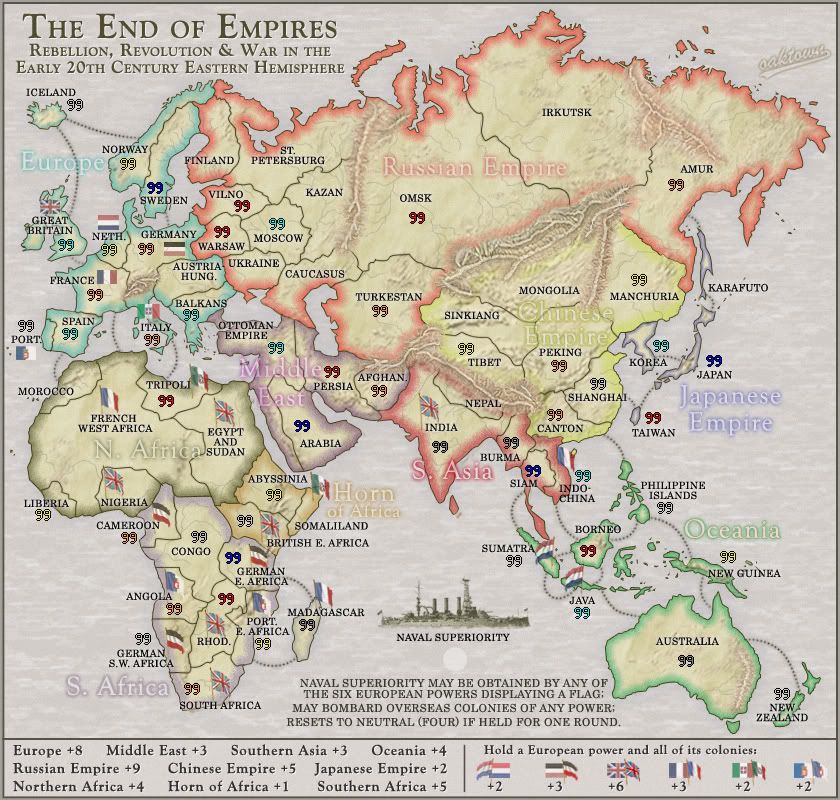
oaktown wrote:Added an atack route between Borneo and French Indochina; the continuing concern was that Australia wasn't worth the bonus of +4, so now it has another much-needed border to defend, while Indochine was already a border territory.

in isolation, this improvement virtually manages to justify the +4 for oceania on its own.

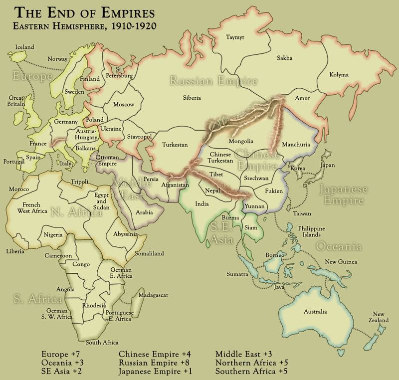
i noticed that the chinese empire is identical to classic europe in terms of having 4 border territories out of 7, while it neighbours 4 continents instead of classic europe's 3. it therefore deserves the same +5 bonus as classic europe, especially given its vulnerable position relative to oceania, and u have also made this change.

one minor tweak: for southern asia's benefit, if the borneo attack route goes to siam and not indochina, then the continent can defend itself against oceania from a single territory. this is only of slight benefit to southern asia (whose +3 bonus looked adequate before the borneo route was added, but is barely so now), but it does at least have the merit of making political and ethnological sense, since british-ruled malay people inhabited both the malay peninsula (southern siam on our map) and north borneo.

ian. :)
User avatar
Brigadier iancanton
Foundry Foreman
Foundry Foreman
 
Posts: 2443
Joined: Fri Jun 01, 2007 5:40 am
Location: europe

Re: Eastern Hemisphere; mntn work pg 32 [D, Gp, Gfx]

Postby LED ZEPPELINER on Tue Feb 10, 2009 8:17 pm

this is just me picking out the details, but the upper part of the border of nigeria runs throught the cameroon border just a touch, you don't have to change it if you do't want
Sergeant LED ZEPPELINER
 
Posts: 1088
Joined: Tue Nov 25, 2008 10:09 pm

Re: Eastern Hemisphere; mntn work pg 32 [D, Gp, Gfx]

Postby captainwalrus on Tue Feb 10, 2009 8:57 pm

LED ZEPPELINER wrote:this is just me picking out the details, but the upper part of the border of nigeria runs throught the cameroon border just a touch, you don't have to change it if you do't want

Good catch! you must be studying this a lot to find that.

The horn of Africa should be +2 because it has 3 vulnerable territories.
User avatar
Private 1st Class captainwalrus
 
Posts: 1018
Joined: Sun Nov 11, 2007 3:19 pm
Location: Finnmark

Re: Eastern Hemisphere; mntn work pg 32 [D, Gp, Gfx]

Postby oaktown on Tue Feb 10, 2009 9:22 pm

Click image to enlarge.
image


iancanton wrote:one minor tweak: for southern asia's benefit, if the borneo attack route goes to siam and not indochina, then the continent can defend itself against oceania from a single territory. this is only of slight benefit to southern asia (whose +3 bonus looked adequate before the borneo route was added, but is barely so now), but it does at least have the merit of making political and ethnological sense, since british-ruled malay people inhabited both the malay peninsula (southern siam on our map) and north borneo.

Nice catch ian. I hadn't considered the impact that the other attack route had on S. Asia - now they can expand into china without having an additional exposed border.

LED ZEPPELINER wrote:this is just me picking out the details, but the upper part of the border of nigeria runs throught the cameroon border just a touch, you don't have to change it if you do't want

Thanks Led... fixed this and some other border issues that have been bugging me a bit.

Other changes include giving the Naval Superiority text the same light drop shadow that the legend text has, adding some mountains to Mongolia, and softening the continental outer glow which was obscuring the sea routes.

no comments on the softer mountains?
User avatar
Captain oaktown
 
Posts: 4451
Joined: Sun Dec 03, 2006 9:24 pm
Location: majorcommand

Re: Eastern Hemisphere; mntn work pg 32 [D, Gp, Gfx]

Postby pamoa on Wed Feb 11, 2009 5:11 am

Frankly you did an absolute incredible work on those mountains and they are beautiful =D>
The blending with continent texture is perfect.
For me one of the best map on CC.

Boys just to remember where we came from... 8-[
Click image to enlarge.
image


Now XML it and go to FF
Last edited by pamoa on Wed Feb 11, 2009 9:12 am, edited 1 time in total.
De gueules à la tour d'argent ouverte, crénelée de trois pièces, sommée d'un donjon ajouré, crénelé de deux pièces
Gules an open tower silver, crenellated three parts, topped by a apertured turret, crenellated two parts
User avatar
Cadet pamoa
 
Posts: 1242
Joined: Sat Sep 01, 2007 3:18 am
Location: Confederatio Helvetica

Re: Eastern Hemisphere; Jury in, changes made [D, Gp, Gfx]

Postby sailorseal on Wed Feb 11, 2009 8:05 am

oaktown wrote:
yeti_c wrote:
oaktown wrote:it will now be up to me to make it clear that they are, in fact, mountains and not tree roots.


Look like Mountains to me.

C.

Thanks yeti... and that new medal looks good on you. =D>

I always thought of it has the "wicked" medal but I am glad to see someone worth while get it!(BOB ROCKS!)
but about the map I like the changes you made and my thumbs are up :D to have this in the FF
User avatar
Cook sailorseal
 
Posts: 2735
Joined: Sun May 25, 2008 1:49 pm
Location: conquerclub.com

Re: Eastern Hemisphere; mntn work pg 32 [D, Gp, Gfx]

Postby LED ZEPPELINER on Wed Feb 11, 2009 10:39 am

oaktown wrote:
LED ZEPPELINER wrote:this is just me picking out the details, but the upper part of the border of nigeria runs throught the cameroon border just a touch, you don't have to change it if you do't want

Thanks Led... fixed this and some other border issues that have been bugging me a bit.

no comments on the softer mountains?

the borders look a lot better now, as for the mountains, i like the older ones better, these look to shallow, and don't resemble mountains as much, good work though, almost there =D>
sailorseal wrote:My big boy banana was out the whole time :D
AndyDufresne wrote:
AndyDufresne wrote:Many Happy Bananas to everyone, lets party...with Bananas.
--Andy
Forever linked at the hip's-banana! (That sounds strange, don't quote me.)
Sergeant LED ZEPPELINER
 
Posts: 1088
Joined: Tue Nov 25, 2008 10:09 pm

Re: Eastern Hemisphere; Jury in, changes made [D, Gp, Gfx]

Postby oaktown on Wed Feb 11, 2009 11:10 am

sailorseal wrote:I like the changes you made and my thumbs are up :D to have this in the FF

Technically that's the third vote to advance, but I haven't heard from three members of the jury since the last two rounds of changes and I'd feel better if there were more review.
User avatar
Captain oaktown
 
Posts: 4451
Joined: Sun Dec 03, 2006 9:24 pm
Location: majorcommand

Re: Eastern Hemisphere; mntn work pg 32 [D, Gp, Gfx]

Postby ZeakCytho on Wed Feb 11, 2009 11:18 am

All of the issues I had with this were addressed in the last two updates.

To the FF!
User avatar
Captain ZeakCytho
 
Posts: 1251
Joined: Wed Sep 12, 2007 4:36 pm

Re: Eastern Hemisphere; mntn work pg 32 [D, Gp, Gfx]

Postby LED ZEPPELINER on Wed Feb 11, 2009 11:25 am

i would suggest getting rid of those really small islands that don't really do anything becuase i look at them and i think there is dust on my comp screen. also, maybe you could try some river impassables in addition to the mountains, maybe the Nile or something
Sergeant LED ZEPPELINER
 
Posts: 1088
Joined: Tue Nov 25, 2008 10:09 pm

Re: Eastern Hemisphere; mntn work pg 32 [D, Gp, Gfx]

Postby reggie_mac on Wed Feb 11, 2009 11:11 pm

Oak, your mountains kick teh ass, Nice job, very nice job.

LED ZEPPELINER wrote:i would suggest getting rid of those really small islands that don't really do anything becuase i look at them and i think there is dust on my comp screen. also, maybe you could try some river impassables in addition to the mountains, maybe the Nile or something


I think these islands need to stay, it adds to the effect of the land masses in the same sort of way that the other terrain make the mountains blend in (to see what i mean look at the difference between v1 Manchuria and the current one).

I still have a bit of trouble picking out the 'Chinese Empire' text, but then again i'd have to be a total retard to not be able to figure it out. And the one thing in not sold on (come on, there had to be one) is the background texture, with the extra texturing you put in to sort the mountains it just doesn't feel right, but i'll live with it.

The island above Omsk (Novaya Zemlya) is 2 islands rather than 1, with the Matochkin Straight running between them, but then its not overly important.

Move it to the FF already :) im looking forward to playing it.
Soviet Invaders: Space Invaders, it's not just a game
New Zealand Map - Foundry
"You can please all of the people some of the time, or some of the people all of the time, but not all of the people all of the time"
User avatar
Captain reggie_mac
 
Posts: 299
Joined: Fri Nov 30, 2007 4:06 pm
Location: Queenstown, NZ

Re: Eastern Hemisphere; New Empire! pg 28 [D, Gp]

Postby oaktown on Sun Feb 15, 2009 11:48 am

ZeakCytho wrote:Move this sucker to the FF!

samuelc812 wrote:Other than that i see no reason to hold this back, move it to the forge :)

sailorseal wrote:I like the changes you made and my thumbs are up :D to have this in the FF

Hopefully I have addressed the concerns of samuelc812, so I will consider his to be a vote in favor of advancement...

              Final Forge

---The Eastern Hemisphere Map has reached the ‘Final Forge’ Stage. The map has passed rigorous gameplay and graphics examinations, and has been approved by a jury of Foundry members. If you have any other concerns, please make your voice heard. If after a reasonable amount of time there has not been any objection or protest, the map will be deemed finished with the 'Foundry Brand' of approval and will be submitted for live play. As long as there is still discussion or posts that have yet to be commented on, the map will remain in Final Forge until said discussion has reached the conclusion that the map has reached its final and polished version.

Post questions and concerns if any.

              Image
User avatar
Captain oaktown
 
Posts: 4451
Joined: Sun Dec 03, 2006 9:24 pm
Location: majorcommand

Re: Eastern Hemisphere; mntn work pg 32 [D, Gp, Gfx]

Postby the.killing.44 on Sun Feb 15, 2009 11:52 am

Image
Naughty naughty map (and oak)! :P

.44
User avatar
Captain the.killing.44
 
Posts: 4724
Joined: Thu Oct 23, 2008 7:43 pm
Location: now tell me what got two gums and knows how to spit rhymes

Re: Eastern Hemisphere; mntn work pg 32 [D, Gp, Gfx]

Postby oaktown on Sun Feb 15, 2009 12:50 pm

the.killing.44 wrote:Naughty naughty map (and oak)! :P

Damn, I was being so good about not making that mistake. At least I did it on my own map. (Doh!)
User avatar
Captain oaktown
 
Posts: 4451
Joined: Sun Dec 03, 2006 9:24 pm
Location: majorcommand

Re: Eastern Hemisphere; mntn work pg 32 [D, Gp, Gfx]

Postby sailorseal on Sun Feb 15, 2009 4:09 pm

Does this mean all maps have to go through a jury? Because I want to be on another...
User avatar
Cook sailorseal
 
Posts: 2735
Joined: Sun May 25, 2008 1:49 pm
Location: conquerclub.com

Re: Eastern Hemisphere; mntn work pg 32 [D, Gp, Gfx]

Postby oaktown on Mon Feb 16, 2009 7:07 pm

XML finished... here are the large and small maps with coordinates. Note that I need to redo the Naval Superiority circle on the small map - I got it all wrong somehow.

Click image to enlarge.
image

Click image to enlarge.
image


Code: Select all
<?xml version="1.0"?>
<map>
   <title>Hemisphere</title>
   <smallwidth>630</smallwidth>
   <smallheight>600</smallheight>
   <largewidth>840</largewidth>
   <largeheight>800</largeheight>
   <filetype>jpg</filetype>

<positions>
   <position>
      <territory>Great Britain</territory>
   </position>
   <position>
      <territory>Germany</territory>
   </position>
   <position>
      <territory>Netherlands</territory>
   </position>
   <position>
      <territory>Austria-Hungary</territory>
   </position>
   <position>
      <territory>Italy</territory>
   </position>
   <position>
      <territory>France</territory>
   </position>
   <position>
      <territory>Portugal</territory>
   </position>
   <position>
      <territory>Spain</territory>
   </position>
</positions>

   <continent>
      <name>Europe</name>
      <bonus>8</bonus>
      <components>
         <territory>Iceland</territory>
         <territory>Great Britain</territory>
         <territory>Norway</territory>
         <territory>Sweden</territory>
         <territory>Germany</territory>
         <territory>Netherlands</territory>
         <territory>Austria-Hungary</territory>
         <territory>Balkans</territory>
         <territory>Italy</territory>
         <territory>France</territory>
         <territory>Spain</territory>
         <territory>Portugal</territory>
      </components>
   </continent>

   <continent>
      <name>Northern Africa</name>
      <bonus>4</bonus>
      <components>
         <territory>Morocco</territory>
         <territory>French West Africa</territory>
         <territory>Tripoli</territory>
         <territory>Liberia</territory>
         <territory>Nigeria</territory>
         <territory>Egypt and Sudan</territory>
         </components>
   </continent>

   <continent>
      <name>Horn of Africa</name>
      <bonus>1</bonus>
      <components>
         <territory>Somaliland</territory>   
         <territory>Abyssinia</territory>
         <territory>British East Africa</territory>
         </components>
   </continent>

   <continent>
      <name>Southern Africa</name>
      <bonus>5</bonus>
      <components>
         <territory>Cameroon</territory>
         <territory>Congo</territory>
         <territory>German East Africa</territory>
         <territory>German South West Africa</territory>
         <territory>Rhodesia</territory>
         <territory>Angola</territory>
         <territory>Madagascar</territory>
         <territory>South Africa</territory>
         <territory>Portuguese East Africa</territory>
      </components>
   </continent>

   <continent>
      <name>Russian Empire</name>
      <bonus>9</bonus>
      <components>
         <territory>St. Petersburg</territory>
         <territory>Finland</territory>
         <territory>Vilno</territory>
         <territory>Warsaw</territory>
         <territory>Ukraine</territory>
         <territory>Moscow</territory>
         <territory>Kazan</territory>
         <territory>Caucasus</territory>
         <territory>Turkestan</territory>
         <territory>Omsk</territory>
         <territory>Irkutsk</territory>
         <territory>Amur</territory>
      </components>
   </continent>

   <continent>
      <name>Middle East</name>
      <bonus>3</bonus>
      <components>
         <territory>Ottoman Empire</territory>
         <territory>Arabia</territory>
         <territory>Persia</territory>
         <territory>Afghanistan</territory>
      </components>
   </continent>

   <continent>
      <name>Chinese Empire</name>
      <bonus>5</bonus>
      <components>
         <territory>Manchuria</territory>
         <territory>Mongolia</territory>
         <territory>Sinkiang</territory>
         <territory>Peking</territory>
         <territory>Tibet</territory>
         <territory>Shanghai</territory>
         <territory>Canton</territory>
      </components>
   </continent>

   <continent>
      <name>Oceania</name>
      <bonus>4</bonus>
      <components>
         <territory>Philippine Islands</territory>
         <territory>Borneo</territory>
         <territory>New Guinea</territory>
         <territory>Sumatra</territory>
         <territory>Java</territory>
         <territory>Australia</territory>
         <territory>New Zealand</territory>
      </components>
   </continent>
      
   <continent>
      <name>Japanese Empire</name>
      <bonus>2</bonus>
      <components>
         <territory>Japan</territory>
         <territory>Korea</territory>
         <territory>Karafuto</territory>
         <territory>Taiwan</territory>
      </components>
   </continent>
   
   <continent>
      <name>British Empire</name>
      <bonus>6</bonus>
      <components>
         <territory>Great Britain</territory>
         <territory>Rhodesia</territory>
         <territory>South Africa</territory>
         <territory>Nigeria</territory>
         <territory>India</territory>
         <territory>Egypt and Sudan</territory>
         <territory>British East Africa</territory>
      </components>
   </continent>   
   
   <continent>
      <name>Portuguese Empire</name>
      <bonus>2</bonus>
      <components>
         <territory>Portugal</territory>
         <territory>Angola</territory>
         <territory>Portuguese East Africa</territory>
      </components>
   </continent>
   
   <continent>
      <name>French Empire</name>
      <bonus>3</bonus>
      <components>
         <territory>France</territory>
         <territory>Madagascar</territory>
         <territory>Indochina</territory>
         <territory>French West Africa</territory>
      </components>
   </continent>   
   
   <continent>
      <name>German Empire</name>
      <bonus>3</bonus>
      <components>
         <territory>Germany</territory>
         <territory>Cameroon</territory>
         <territory>German South West Africa</territory>
         <territory>German East Africa</territory>
      </components>
   </continent>      
   
   <continent>
      <name>Dutch Empire</name>
      <bonus>2</bonus>
      <components>
         <territory>Netherlands</territory>
         <territory>Sumatra</territory>
         <territory>Java</territory>
      </components>
   </continent>      

   <continent>
      <name>Italian Empire</name>
      <bonus>2</bonus>
      <components>
         <territory>Italy</territory>
         <territory>Tripoli</territory>
         <territory>Somaliland</territory>
      </components>
   </continent>      
   
   <territory>
      <name>Iceland</name>
      <borders>
         <border>Norway</border>
         <border>Great Britain</border>
      </borders>
            <coordinates>
         <smallx>54</smallx>
         <smally>103</smally>
         <largex>71</largex>
         <largey>127</largey>
      </coordinates>
   </territory>
   <territory>
      <name>Great Britain</name>
      <borders>
         <border>Iceland</border>
         <border>France</border>
         <border>Naval Superiority</border>
      </borders>
            <coordinates>
         <smallx>45</smallx>
         <smally>206</smally>
         <largex>63</largex>
         <largey>267</largey>
      </coordinates>
   </territory>
   <territory>
      <name>Norway</name>
      <borders>
         <border>Iceland</border>
         <border>Sweden</border>
         <border>Finland</border>
      </borders>
            <coordinates>
         <smallx>91</smallx>
         <smally>146</smally>
         <largex>123</largex>
         <largey>185</largey>
      </coordinates>
   </territory>
   <territory>
      <name>Sweden</name>
      <borders>
         <border>Norway</border>
         <border>Germany</border>
         <border>Finland</border>
      </borders>
            <coordinates>
         <smallx>114</smallx>
         <smally>162</smally>
         <largex>150</largex>
         <largey>210</largey>
      </coordinates>
   </territory>
   <territory>
      <name>France</name>
      <borders>
         <border>Great Britain</border>
         <border>Spain</border>
         <border>Netherlands</border>
         <border>Italy</border>
         <border>Germany</border>
         <border>French West Africa</border>
         <border>Naval Superiority</border>
      </borders>
            <coordinates>
         <smallx>67</smallx>
         <smally>244</smally>
         <largex>90</largex>
         <largey>317</largey>
      </coordinates>
   </territory>
   <territory>
      <name>Spain</name>
      <borders>
         <border>Portugal</border>
         <border>Morocco</border>
         <border>France</border>
      </borders>
            <coordinates>
         <smallx>48</smallx>
         <smally>274</smally>
         <largex>65</largex>
         <largey>356</largey>
      </coordinates>
   </territory>
   <territory>
      <name>Portugal</name>
      <borders>
         <border>Spain</border>
         <border>Naval Superiority</border>
      </borders>
            <coordinates>
         <smallx>16</smallx>
         <smally>266</smally>
         <largex>22</largex>
         <largey>349</largey>
      </coordinates>
   </territory>
   <territory>
      <name>Germany</name>
      <borders>
         <border>France</border>
         <border>Netherlands</border>
         <border>Sweden</border>
         <border>Warsaw</border>
         <border>Austria-Hungary</border>
         <border>Vilno</border>
         <border>Naval Superiority</border>
      </borders>
            <coordinates>
         <smallx>107</smallx>
         <smally>210</smally>
         <largex>142</largex>
         <largey>271</largey>
      </coordinates>
   </territory>
   <territory>
      <name>Austria-Hungary</name>
      <borders>
         <border>Germany</border>
         <border>Warsaw</border>
         <border>Ukraine</border>
         <border>Balkans</border>
         <border>Italy</border>
      </borders>
            <coordinates>
         <smallx>125</smallx>
         <smally>237</smally>
         <largex>168</largex>
         <largey>308</largey>
      </coordinates>
   </territory>
   <territory>
      <name>Italy</name>
      <borders>
         <border>France</border>
         <border>Austria-Hungary</border>
         <border>Tripoli</border>         
         <border>Naval Superiority</border>
      </borders>
            <coordinates>
         <smallx>109</smallx>
         <smally>278</smally>
         <largex>146</largex>
         <largey>361</largey>
      </coordinates>
   </territory>
   <territory>
      <name>Netherlands</name>
      <borders>
         <border>France</border>
         <border>Germany</border>
         <border>Naval Superiority</border>
      </borders>
            <coordinates>
         <smallx>78</smallx>
         <smally>210</smally>
         <largex>105</largex>
         <largey>272</largey>
      </coordinates>
   </territory>
   <territory>
      <name>Balkans</name>
      <borders>
         <border>Austria-Hungary</border>
         <border>Ukraine</border>
         <border>Ottoman Empire</border>
      </borders>
            <coordinates>
         <smallx>140</smallx>
         <smally>261</smally>
         <largex>187</largex>
         <largey>337</largey>
      </coordinates>
   </territory>
   
   
   <territory>
      <name>Morocco</name>
      <borders>
         <border>Spain</border>
         <border>French West Africa</border>
      </borders>
            <coordinates>
         <smallx>57</smallx>
         <smally>306</smally>
         <largex>77</largex>
         <largey>400</largey>
      </coordinates>
   </territory>
   <territory>
      <name>Liberia</name>
      <borders>
         <border>French West Africa</border>
      </borders>
            <coordinates>
         <smallx>29</smallx>
         <smally>411</smally>
         <largex>39</largex>
         <largey>538</largey>
           </coordinates>
   </territory>
   <territory>
      <name>French West Africa</name>
      <borders>
         <border>France</border>
         <border>Tripoli</border>
         <border>Morocco</border>
         <border>Liberia</border>
         <border>Nigeria</border>
         <border>Cameroon</border>
         <border>Congo</border>
         <border>Egypt and Sudan</border>
      </borders>      
            <coordinates>
         <smallx>54</smallx>
         <smally>354</smally>
         <largex>73</largex>
         <largey>463</largey>
      </coordinates>
   </territory>
   <territory>
      <name>Tripoli</name>
      <borders>
         <border>French West Africa</border>
         <border>Italy</border>
         <border>Egypt and Sudan</border>
      </borders>
            <coordinates>
         <smallx>120</smallx>
         <smally>323</smally>
         <largex>162</largex>
         <largey>423</largey>
      </coordinates>
   </territory>
   <territory>
      <name>Nigeria</name>
      <borders>
         <border>French West Africa</border>
         <border>Cameroon</border>
      </borders>   
            <coordinates>
         <smallx>100</smallx>
         <smally>387</smally>
         <largex>135</largex>
         <largey>508</largey>
      </coordinates>
   </territory>
   <territory>
      <name>Egypt and Sudan</name>
      <borders>
         <border>Tripoli</border>
         <border>French West Africa</border>
         <border>Abyssinia</border>
         <border>Ottoman Empire</border>
         <border>Congo</border>
         <border>British East Africa</border>
      </borders>   
            <coordinates>
         <smallx>161</smallx>
         <smally>374</smally>
         <largex>216</largex>
         <largey>491</largey>
      </coordinates>
   </territory>
   
   
   <territory>
      <name>Abyssinia</name>
      <borders>
         <border>Egypt and Sudan</border>
         <border>Somaliland</border>
         <border>British East Africa</border>
      </borders>
            <coordinates>
         <smallx>199</smallx>
         <smally>393</smally>
         <largex>266</largex>
         <largey>517</largey>
      </coordinates>
   </territory>
   <territory>
      <name>Somaliland</name>
      <borders>
         <border>Abyssinia</border>
         <border>British East Africa</border>
      </borders>
            <coordinates>
         <smallx>230</smallx>
         <smally>406</smally>
         <largex>308</largex>
         <largey>534</largey>
      </coordinates>
   </territory>
   <territory>
      <name>British East Africa</name>
      <borders>
         <border>Abyssinia</border>
         <border>Somaliland</border>
         <border>Congo</border>
         <border>German East Africa</border>
         <border>Egypt and Sudan</border>
      </borders>
            <coordinates>
         <smallx>179</smallx>
         <smally>413</smally>
         <largex>240</largex>
         <largey>543</largey>
      </coordinates>
   </territory>   
   
   <territory>
      <name>Cameroon</name>
      <borders>
         <border>Congo</border>
         <border>Nigeria</border>
         <border>French West Africa</border>
      </borders>      
            <coordinates>   
         <smallx>92</smallx>
         <smally>427</smally>
         <largex>125</largex>
         <largey>560</largey>
      </coordinates>
   </territory>
   <territory>
      <name>Congo</name>
      <borders>
         <border>Angola</border>
         <border>Cameroon</border>
         <border>French West Africa</border>
         <border>German East Africa</border>
         <border>Rhodesia</border>
         <border>Egypt and Sudan</border>
         <border>British East Africa</border>
      </borders>
            <coordinates>
         <smallx>145</smallx>
         <smally>423</smally>
         <largex>195</largex>
         <largey>557</largey>
      </coordinates>
   </territory>
   <territory>
      <name>Angola</name>
      <borders>
         <border>Congo</border>
         <border>Rhodesia</border>
         <border>German South West Africa</border>
      </borders>
            <coordinates>         <smallx>126</smallx>
         <smally>480</smally>
         <largex>169</largex>
         <largey>632</largey>

      </coordinates>
   </territory>
   <territory>
      <name>German South West Africa</name>
      <borders>
         <border>South Africa</border>
         <border>Rhodesia</border>
         <border>Angola</border>
      </borders>      
            <coordinates>
         <smallx>103</smallx>
         <smally>501</smally>
         <largex>139</largex>
         <largey>661</largey>
      </coordinates>
   </territory>
   <territory>
      <name>South Africa</name>
      <borders>
         <border>German South West Africa</border>
         <border>Rhodesia</border>
         <border>Portuguese East Africa</border>
      </borders>      
            <coordinates>
         <smallx>139</smallx>
         <smally>539</smally>
         <largex>187</largex>
         <largey>713</largey>
      </coordinates>
   </territory>
   <territory>
      <name>Rhodesia</name>
      <borders>
         <border>Congo</border>
         <border>Angola</border>
         <border>German South West Africa</border>
         <border>South Africa</border>
         <border>Portuguese East Africa</border>
         <border>German East Africa</border>
      </borders>      
            <coordinates>
         <smallx>166</smallx>
         <smally>470</smally>
         <largex>223</largex>
         <largey>620</largey>
      </coordinates>
   </territory>
   <territory>
      <name>Portuguese East Africa</name>
      <borders>
         <border>Madagascar</border>
         <border>Rhodesia</border>
         <border>South Africa</border>
         <border>German East Africa</border>
      </borders>
            <coordinates>
         <smallx>191</smallx>
         <smally>507</smally>
         <largex>259</largex>
         <largey>667</largey>
      </coordinates>
   </territory>
   <territory>
      <name>Madagascar</name>
      <borders>
         <border>Portuguese East Africa</border>
         <border>German East Africa</border>
      </borders>
            <coordinates>
         <smallx>225</smallx>
         <smally>493</smally>
         <largex>301</largex>
         <largey>649</largey>
      </coordinates>
   </territory>
   <territory>
      <name>German East Africa</name>
      <borders>
         <border>Madagascar</border>
         <border>Congo</border>
         <border>Rhodesia</border>
         <border>Portuguese East Africa</border>
         <border>British East Africa</border>
      </borders>
            <coordinates>
         <smallx>171</smallx>
         <smally>440</smally>
         <largex>230</largex>
         <largey>580</largey>
      </coordinates>
   </territory>
   
   
   <territory>
      <name>Ottoman Empire</name>
      <borders>
         <border>Balkans</border>
         <border>Caucasus</border>
         <border>Persia</border>
         <border>Arabia</border>
         <border>Egypt and Sudan</border>
      </borders>
            <coordinates>
         <smallx>203</smallx>
         <smally>284</smally>
         <largex>270</largex>
         <largey>370</largey>
      </coordinates>
   </territory>
   <territory>
      <name>Arabia</name>
      <borders>
         <border>Ottoman Empire</border>
         <border>Persia</border>
      </borders>
            <coordinates>
         <smallx>223</smallx>
         <smally>342</smally>
         <largex>299</largex>
         <largey>448</largey>
      </coordinates>
   </territory>
   <territory>
      <name>Persia</name>
      <borders>
         <border>Ottoman Empire</border>
         <border>Arabia</border>
         <border>Turkestan</border>
         <border>Afghanistan</border>
         <border>Caucasus</border>
         </borders>
            <coordinates>
         <smallx>247</smallx>
         <smally>300</smally>
         <largex>330</largex>
         <largey>393</largey>
      </coordinates>
   </territory>
   <territory>
      <name>Afghanistan</name>
      <borders>
         <border>India</border>
         <border>Persia</border>
      </borders>
            <coordinates>
         <smallx>280</smallx>
         <smally>316</smally>
         <largex>374</largex>
         <largey>413</largey>
      </coordinates>
   </territory>
   
   
   <territory>
      <name>Finland</name>
      <borders>
         <border>Norway</border>
         <border>Sweden</border>
         <border>St. Petersburg</border>
      </borders>
            <coordinates>
         <smallx>163</smallx>
         <smally>131</smally>
         <largex>218</largex>
         <largey>167</largey>
      </coordinates>
   </territory>
   <territory>
      <name>St. Petersburg</name>
      <borders>
         <border>Kazan</border>
         <border>Vilno</border>
         <border>Moscow</border>
         <border>Finland</border>
      </borders>
            <coordinates>
         <smallx>200</smallx>
         <smally>154</smally>
         <largex>268</largex>
         <largey>198</largey>
      </coordinates>
   </territory>
   <territory>
      <name>Warsaw</name>
      <borders>
         <border>Vilno</border>
         <border>Moscow</border>
         <border>Ukraine</border>
         <border>Germany</border>
         <border>Austria-Hungary</border>
      </borders>
            <coordinates>
         <smallx>163</smallx>
         <smally>196</smally>
         <largex>219</largex>
         <largey>254</largey>
      </coordinates>
   </territory>
   <territory>
      <name>Vilno</name>
      <borders>
         <border>St. Petersburg</border>
         <border>Warsaw</border>
         <border>Moscow</border>
         <border>Germany</border>
      </borders>
            <coordinates>
         <smallx>177</smallx>
         <smally>178</smally>
         <largex>238</largex>
         <largey>228</largey>
      </coordinates>
   </territory>
   <territory>
      <name>Ukraine</name>
      <borders>
         <border>Warsaw</border>
         <border>Moscow</border>   
         <border>Caucasus</border>
         <border>Austria-Hungary</border>
         <border>Balkans</border>         
      </borders>
            <coordinates>
         <smallx>186</smallx>
         <smally>231</smally>
         <largex>249</largex>
         <largey>300</largey>
      </coordinates>
   </territory>
   <territory>
      <name>Moscow</name>
      <borders>
         <border>Vilno</border>
         <border>Ukraine</border>
         <border>Kazan</border>
         <border>St. Petersburg</border>
         <border>Warsaw</border>
         <border>Caucasus</border>
      </borders>
            <coordinates>
         <smallx>203</smallx>
         <smally>190</smally>
         <largex>273</largex>
         <largey>246</largey>
      </coordinates>
   </territory>
   <territory>
      <name>Kazan</name>
      <borders>
         <border>St. Petersburg</border>
         <border>Moscow</border>
         <border>Caucasus</border>
      </borders>
            <coordinates>
         <smallx>240</smallx>
         <smally>181</smally>
         <largex>321</largex>
         <largey>234</largey>
      </coordinates>
   </territory>
   <territory>
      <name>Caucasus</name>
      <borders>
         <border>Kazan</border>
         <border>Turkestan</border>
         <border>Moscow</border>
         <border>Omsk</border>
         <border>Ukraine</border>
         <border>Ottoman Empire</border>
         <border>Persia</border>
      </borders>
            <coordinates>
         <smallx>213</smallx>
         <smally>240</smally>
         <largex>284</largex>
         <largey>313</largey>
      </coordinates>
   </territory>
   <territory>
      <name>Turkestan</name>
      <borders>
         <border>Caucasus</border>
         <border>Sinkiang</border>
         <border>Omsk</border>
         <border>Persia</border>
      </borders>
            <coordinates>
         <smallx>285</smallx>
         <smally>258</smally>
         <largex>381</largex>
         <largey>337</largey>
      </coordinates>
   </territory>
   <territory>
      <name>Omsk</name>
      <borders>
         <border>Irkutsk</border>
         <border>Turkestan</border>
         <border>Caucasus</border>
      </borders>
            <coordinates>   
         <smallx>308</smallx>
         <smally>185</smally>
         <largex>413</largex>
         <largey>238</largey>
      </coordinates>
   </territory>
   <territory>
      <name>Amur</name>
      <borders>
         <border>Karafuto</border>
         <border>Irkutsk</border>
         <border>Manchuria</border>
      </borders>
            <coordinates>
         <smallx>502</smallx>
         <smally>162</smally>
         <largex>670</largex>
         <largey>208</largey>
      </coordinates>
   </territory>
   <territory>
      <name>Irkutsk</name>
      <borders>
         <border>Omsk</border>
         <border>Amur</border>
      </borders>
            <coordinates>
         <smallx>422</smallx>
         <smally>122</smally>
         <largex>564</largex>
         <largey>154</largey>
      </coordinates>
   </territory>
   
   
   <territory>
      <name>Sinkiang</name>
      <borders>
         <border>Tibet</border>
         <border>Peking</border>
         <border>Mongolia</border>
         <border>Turkestan</border>
      </borders>
            <coordinates>
         <smallx>377</smallx>
         <smally>271</smally>
         <largex>503</largex>
         <largey>355</largey>
      </coordinates>
   </territory>
   <territory>
      <name>Tibet</name>
      <borders>
         <border>Sinkiang</border>
         <border>Peking</border>
      </borders>
            <coordinates>
         <smallx>345</smallx>
         <smally>283</smally>
         <largex>461</largex>
         <largey>370</largey>
      </coordinates>
   </territory>
   <territory>
      <name>Mongolia</name>
      <borders>
         <border>Sinkiang</border>
         <border>Peking</border>
      </borders>
            <coordinates>
         <smallx>410</smallx>
         <smally>226</smally>
         <largex>547</largex>
         <largey>295</largey>
      </coordinates>
   </territory>
   <territory>
      <name>Peking</name>
      <borders>
         <border>Sinkiang</border>
         <border>Tibet</border>
         <border>Canton</border>
         <border>Shanghai</border>
         <border>Manchuria</border>
         <border>Mongolia</border>
      </borders>
            <coordinates>      
          <smallx>415</smallx>
         <smally>298</smally>
         <largex>554</largex>
         <largey>390</largey>

      </coordinates>
   </territory>
   <territory>
      <name>Canton</name>
      <borders>
         <border>Peking</border>
         <border>Shanghai</border>
         <border>Indochina</border>
         <border>Burma</border>
         <border>Philippine Islands</border>
      </borders>
            <coordinates>      
         <smallx>412</smallx>
         <smally>332</smally>
         <largex>550</largex>
         <largey>436</largey>

      </coordinates>
   </territory>
   <territory>
      <name>Shanghai</name>
      <borders>
         <border>Peking</border>
         <border>Canton</border>
         <border>Taiwan</border>
      </borders>
            <coordinates>   
         <smallx>444</smallx>
         <smally>310</smally>
         <largex>593</largex>
         <largey>407</largey>
      </coordinates>
   </territory>
   <territory>
      <name>Manchuria</name>
      <borders>
         <border>Amur</border>
         <border>Korea</border>
         <border>Peking</border>
      </borders>
            <coordinates>   
         <smallx>475</smallx>
         <smally>231</smally>
         <largex>635</largex>
         <largey>301</largey>
      </coordinates>
   </territory>   


   <territory>
      <name>India</name>
      <borders>
         <border>Afghanistan</border>
         <border>Nepal</border>
         <border>Burma</border>
      </borders>
                  <coordinates>
         <smallx>327</smallx>
         <smally>355</smally>
         <largex>437</largex>
         <largey>466</largey>
      </coordinates>
   </territory>
   <territory>
      <name>Nepal</name>
      <borders>
         <border>India</border>
      </borders>
            <coordinates>
         <smallx>340</smallx>
         <smally>315</smally>
         <largex>454</largex>
         <largey>415</largey>
      </coordinates>
   </territory>
   <territory>
      <name>Burma</name>
      <borders>
         <border>India</border>
         <border>Siam</border>
         <border>Indochina</border>
         <border>Canton</border>
      </borders>
            <coordinates>   
         <smallx>380</smallx>
         <smally>355</smally>
         <largex>508</largex>
         <largey>465</largey>
      </coordinates>
   </territory>
   <territory>
      <name>Siam</name>
      <borders>
         <border>Burma</border>
         <border>Indochina</border>
         <border>Sumatra</border>
      </borders>
            <coordinates>      
         <smallx>397</smallx>
         <smally>375</smally>
         <largex>531</largex>
         <largey>493</largey>

      </coordinates>
   </territory>
   <territory>
      <name>Indochina</name>
      <borders>
         <border>Canton</border>
         <border>Burma</border>
         <border>Siam</border>
      </borders>
            <coordinates>   
         <smallx>434</smallx>
         <smally>379</smally>
         <largex>580</largex>
         <largey>498</largey>
      </coordinates>
   </territory>   
   
   <territory>
      <name>Japan</name>
      <borders>
         <border>Karafuto</border>
         <border>Korea</border>
         <border>Taiwan</border>
      </borders>
            <coordinates>
         <smallx>532</smallx>
         <smally>292</smally>
         <largex>710</largex>
         <largey>381</largey>
      </coordinates>
   </territory>
   <territory>
      <name>Karafuto</name>
      <borders>
         <border>Amur</border>
         <border>Japan</border>
      </borders>
            <coordinates>
         <smallx>545</smallx>
         <smally>227</smally>
         <largex>728</largex>
         <largey>294</largey>
      </coordinates>
   </territory>
   <territory>
      <name>Korea</name>
      <borders>
         <border>Manchuria</border>
         <border>Japan</border>
      </borders>
            <coordinates>
         <smallx>493</smallx>
         <smally>282</smally>
         <largex>657</largex>
         <largey>369</largey>
      </coordinates>
   </territory>
   <territory>
      <name>Taiwan</name>
      <borders>
         <border>Japan</border>
         <border>Shanghai</border>
      </borders>
            <coordinates>   
         <smallx>486</smallx>
         <smally>336</smally>
         <largex>649</largex>
         <largey>442</largey>
      </coordinates>
   </territory>


   <territory>
      <name>Philippine Islands</name>
      <borders>
         <border>Canton</border>
         <border>Borneo</border>
         <border>New Guinea</border>
      </borders>
            <coordinates>   
         <smallx>498</smallx>
         <smally>405</smally>
         <largex>661</largex>
         <largey>531</largey>
      </coordinates>
   </territory>
   <territory>
      <name>Borneo</name>
      <borders>
         <border>Philippine Islands</border>
         <border>Sumatra</border>
         <border>Java</border>
      </borders>
            <coordinates>   
         <smallx>438</smallx>
         <smally>436</smally>
         <largex>584</largex>
         <largey>573</largey>
      </coordinates>
   </territory>
   <territory>
      <name>Sumatra</name>
      <borders>
         <border>Borneo</border>
         <border>Siam</border>
         <border>Java</border>
      </borders>
            <coordinates>   
         <smallx>379</smallx>
         <smally>445</smally>
         <largex>506</largex>
         <largey>585</largey>
      </coordinates>
   </territory>
   <territory>
      <name>Java</name>
      <borders>
         <border>Borneo</border>
         <border>Sumatra</border>
         <border>Australia</border>
      </borders>
            <coordinates>
         <smallx>432</smallx>
         <smally>484</smally>
         <largex>577</largex>
         <largey>636</largey>
      </coordinates>
   </territory>
   <territory>
      <name>New Guinea</name>
      <borders>
         <border>Philippine Islands</border>
         <border>Australia</border>
      </borders>
            <coordinates>   
         <smallx>542</smallx>
         <smally>438</smally>
         <largex>725</largex>
         <largey>579</largey>
      </coordinates>
   </territory>
   <territory>
      <name>Australia</name>
      <borders>
         <border>Java</border>
         <border>New Guinea</border>
         <border>New Zealand</border>
      </borders>
            <coordinates>
         <smallx>511</smallx>
         <smally>517</smally>
         <largex>682</largex>
         <largey>682</largey>
      </coordinates>
   </territory>
   <territory>
      <name>New Zealand</name>
      <borders>
         <border>Australia</border>
      </borders>
            <coordinates>   
         <smallx>580</smallx>
         <smally>541</smally>
         <largex>774</largex>
         <largey>717</largey>
      </coordinates>
   </territory>


   <territory>
      <name>Naval Superiority</name>
      <borders>
      </borders>
       <bombardments>
       <bombardment>Indochina</bombardment>
         <bombardment>Madagascar</bombardment>
         <bombardment>French West Africa</bombardment>
         <bombardment>Rhodesia</bombardment>
         <bombardment>India</bombardment>
         <bombardment>South Africa</bombardment>
         <bombardment>Egypt and Sudan</bombardment>
         <bombardment>British East Africa</bombardment>
         <bombardment>Sumatra</bombardment>
         <bombardment>Java</bombardment>
         <bombardment>Nigeria</bombardment>
         <bombardment>Cameroon</bombardment>
         <bombardment>German South West Africa</bombardment>
         <bombardment>German East Africa</bombardment>
         <bombardment>Angola</bombardment>
         <bombardment>Portuguese East Africa</bombardment>
         <bombardment>Somaliland</bombardment>         
         <bombardment>Tripoli</bombardment>
        </bombardments>
            <coordinates>   
         <smallx>338</smallx>
         <smally>516</smally>
         <largex>451</largex>
         <largey>681</largey>
      </coordinates>
      <neutral killer="yes">4</neutral>
   </territory>

</map>
User avatar
Captain oaktown
 
Posts: 4451
Joined: Sun Dec 03, 2006 9:24 pm
Location: majorcommand

Re: Eastern Hemisphere; mntn work pg 32 [D, Gp, Gfx]

Postby LED ZEPPELINER on Mon Feb 16, 2009 7:42 pm

does the iceland 88 fit inside the acutall boundaries of the country, if it does i would suggest putting it in there
sailorseal wrote:My big boy banana was out the whole time :D
AndyDufresne wrote:
AndyDufresne wrote:Many Happy Bananas to everyone, lets party...with Bananas.
--Andy
Forever linked at the hip's-banana! (That sounds strange, don't quote me.)
Sergeant LED ZEPPELINER
 
Posts: 1088
Joined: Tue Nov 25, 2008 10:09 pm

Re: Eastern Hemisphere; mntn work pg 32 [D, Gp, Gfx]

Postby oaktown on Mon Feb 16, 2009 7:48 pm

LED ZEPPELINER wrote:does the iceland 88 fit inside the acutall boundaries of the country, if it does i would suggest putting it in there

It would on the large map, but would be messy on the small. I'm OK with the #s not being in the same place on both maps, but I know others are picky about that.
User avatar
Captain oaktown
 
Posts: 4451
Joined: Sun Dec 03, 2006 9:24 pm
Location: majorcommand

Re: Eastern Hemisphere; coordinates! [D, Gp, Gfx]

Postby sailorseal on Mon Feb 16, 2009 9:27 pm

Now were in the forge can someone call andy and his quenched stamp? :D
User avatar
Cook sailorseal
 
Posts: 2735
Joined: Sun May 25, 2008 1:49 pm
Location: conquerclub.com

Re: Eastern Hemisphere; coordinates! [D, Gp, Gfx]

Postby the.killing.44 on Mon Feb 16, 2009 9:36 pm

sailorseal wrote:Now were in the forge can someone call andy and his quenched stamp? :D

Hold yer horses … oak still needs to fix up the army circle on the small like he said.
Things I suggest:
  • Nepal's 88 over 1-2px, maybe up 1px?
  • Yes, have the Iceland 88 within the territory on the large
  • How does having "Ottoman Empire" inside the territory and moving the 88 a bit to right look?

I'd like to see this with 888s on it…

.44
User avatar
Captain the.killing.44
 
Posts: 4724
Joined: Thu Oct 23, 2008 7:43 pm
Location: now tell me what got two gums and knows how to spit rhymes

Re: Eastern Hemisphere; coordinates! [D, Gp, Gfx]

Postby oaktown on Mon Feb 16, 2009 9:36 pm

sailorseal wrote:Now were in the forge can someone call andy and his quenched stamp? :D

Well, let's wait until its ready. I still need to fix the N.S. circle, move some coordinates around, and get the XML cleared by Forza. it's better to do this right than to do it fast.
User avatar
Captain oaktown
 
Posts: 4451
Joined: Sun Dec 03, 2006 9:24 pm
Location: majorcommand

Re: Eastern Hemisphere; coordinates! [D, Gp, Gfx]

Postby pamoa on Tue Feb 17, 2009 3:21 am

In the legend box, why are Netherlands flags displayed reversed "colonies/country" instead of "country/colonies"
De gueules à la tour d'argent ouverte, crénelée de trois pièces, sommée d'un donjon ajouré, crénelé de deux pièces
Gules an open tower silver, crenellated three parts, topped by a apertured turret, crenellated two parts
User avatar
Cadet pamoa
 
Posts: 1242
Joined: Sat Sep 01, 2007 3:18 am
Location: Confederatio Helvetica

Re: Eastern Hemisphere; Jury Summoned! [D, Gp, Gfx]

Postby WidowMakers on Tue Feb 17, 2009 6:07 pm

oaktown wrote:
Click image to enlarge.
image


The Australia range remains, but it is much less prominent I hope. The other ranges have had their highlights brought down and shadows brought up (love those dodge and burn tools) in hopes that they will contrast less with their surroundings. Also, I have added considerably more texture mountains to the landscape in more or less appropriate places. My hope is that everything blends together better now.
Sorry for posting so late but the changes you made are awesome. I love the newer, toned-down mountains and the added hills and smaller ranges that lead up to them. They blend in much better and make the map look much better overall.

As far as the army circles go, I think it looks great without them now. You moved everything well and it all fits with the "88" still being readable.

Map looks great.

WM
Image
Major WidowMakers
 
Posts: 2774
Joined: Mon Nov 20, 2006 9:25 am
Location: Detroit, MI

Re: Eastern Hemisphere; coordinates! [D, Gp, Gfx]

Postby oaktown on Tue Feb 17, 2009 9:25 pm

Click image to enlarge.
image

Click image to enlarge.
image

Small and large, with minimal changes. Army circle for the ship has been set right on the small map. And...

pamoa wrote:In the legend box, why are Netherlands flags displayed reversed "colonies/country" instead of "country/colonies"

Well, because many were complaining about how some of the European flags were too similar... the Dutch flag is blowing west-ward, while the others are blowing to the east. I've retained the opposite wave direction, but put them in the same order in the legend. I don't know if it's any better, but at least it is consistent.

I'll tinker with a few coordinates this evening since I must await a second check of the (corrected) XML. (Doh!) If anybody wants to volunteer to do a final coordinate check, be my guest.

Large: http://i141.photobucket.com/albums/r76/ ... here48.jpg
Small: http://i141.photobucket.com/albums/r76/ ... ere48S.jpg
Code: http://www.fileden.com/files/2008/7/30/ ... sphere.xml
Map Inspect: http://www.conquerclub.com/mapmaker/index.php
User avatar
Captain oaktown
 
Posts: 4451
Joined: Sun Dec 03, 2006 9:24 pm
Location: majorcommand

Re: Eastern Hemisphere; coordinates! [D, Gp, Gfx]

Postby oaktown on Tue Feb 17, 2009 9:43 pm

the.killing.44 wrote:Nepal's 88 over 1-2px, maybe up 1px?

Moved it up on the large map, but any higher on the small map and it's getting into China.

the.killing.44 wrote:Yes, have the Iceland 88 within the territory on the large

Done.

the.killing.44 wrote:How does having "Ottoman Empire" inside the territory and moving the 88 a bit to right look?

That title is where it is so as not to mislead players - the territory spans the Bosporus and include the European bit that borders the Balkans.

the.killing.44 wrote:I'd like to see this with 888s on it…

Links are above - you can see it with any number you want!
This is my bid to get somebody to do some coordinate inspection for me. ;)
User avatar
Captain oaktown
 
Posts: 4451
Joined: Sun Dec 03, 2006 9:24 pm
Location: majorcommand

PreviousNext

Return to The Atlas

Who is online

Users browsing this forum: No registered users